List of Isle of Man railway lines and locations

Last updated

Map all coordinatesin "List of Isle of Man railway lines and locations" using: OpenStreetMap

The Isle of Man has many railway lines, both current and historical. This is a list of those lines intended to carry passengers, either for public transport, local convenience, or as a tourist attraction. For many of the lines, locations such as stations, stops and depots are listed.

Contents

Isle of Man Railway – South Line

Map this section's coordinatesin "List of Isle of Man railway lines and locations" using: OpenStreetMap
Point Coordinates
(Links to map resources)
OS Grid Ref Notes
Douglas 54°08′52″N4°29′10″W / 54.1478°N 4.4861°W / 54.1478; -4.4861 (Douglas Station) SC37727529
Port Soderick 54°07′35″N4°32′18″W / 54.1265°N 4.5384°W / 54.1265; -4.5384 (Port Soderick Station) SC34227305
Santon 54°07′06″N4°35′03″W / 54.1182°N 4.5841°W / 54.1182; -4.5841 (Santon Station) SC31207223
Ballasalla 54°05′46″N4°37′44″W / 54.0961°N 4.6288°W / 54.0961; -4.6288 (Ballasalla Station) SC28196988
Ronaldsway 54°05′17″N4°38′33″W / 54.0881°N 4.6425°W / 54.0881; -4.6425 (Ronaldsway Halt) SC27266902
Castletown 54°04′43″N4°38′56″W / 54.0787°N 4.6488°W / 54.0787; -4.6488 (Castletown Station) SC26816799
Ballabeg 54°05′28″N4°40′26″W / 54.0911°N 4.6739°W / 54.0911; -4.6739 (Ballabeg Station) SC25226943
Colby 54°05′40″N4°42′15″W / 54.0944°N 4.7042°W / 54.0944; -4.7042 (Colby Station) SC23256988
The Level 54°05′29″N4°43′16″W / 54.0914°N 4.7211°W / 54.0914; -4.7211 (The Level Station) SC22136959
Port St Mary 54°04′52″N4°44′35″W / 54.081°N 4.743°W / 54.081; -4.743 (Port St Mary Station) SC20666848
Port Erin 54°05′06″N4°45′29″W / 54.085°N 4.758°W / 54.085; -4.758 (Port Erin Station) SC19696897

Isle of Man Railway – Peel Line (closed)

Map this section's coordinatesin "List of Isle of Man railway lines and locations" using: OpenStreetMap
Point Coordinates
(Links to map resources)
OS Grid Ref Notes
Peel 54°13′19″N4°41′51″W / 54.2219°N 4.6974°W / 54.2219; -4.6974 (Peel Station) SC24248404
Knockaloe railway station and branch line 54°12′20″N4°42′14″W / 54.2055°N 4.7038°W / 54.2055; -4.7038 (Knockaloe railway station) SC23758223
Knockaloe Internment Camp 54°12′19″N4°42′17″W / 54.2054°N 4.7046°W / 54.2054; -4.7046 (Knockaloe Internment Camp) SC23708222
St John's 54°12′04″N4°38′29″W / 54.2012°N 4.6415°W / 54.2012; -4.6415 (St John's Station) SC27798160
Ballacraine 54°11′55″N4°37′57″W / 54.1986°N 4.6325°W / 54.1986; -4.6325 (Ballacraine Halt) SC28378129
Crosby 54°10′55″N4°33′58″W / 54.182°N 4.566°W / 54.182; -4.566 (Crosby Station) SC32647928
Union Mills 54°10′08″N4°31′12″W / 54.169°N 4.52°W / 54.169; -4.52 (Union Mills Station) SC35597773
Braddan Bridge § Railway halt 54°09′41″N4°30′20″W / 54.1615°N 4.5056°W / 54.1615; -4.5056 (Braddan Halt) SC36507686
Quarterbridge Crossing 54°09′21″N4°30′06″W / 54.1558°N 4.5017°W / 54.1558; -4.5017 (Quarterbridge Crossing) SC36737622
Douglas 54°08′52″N4°29′10″W / 54.1478°N 4.4861°W / 54.1478; -4.4861 (Douglas Station) SC37727529

Isle of Man Railway – North Line (closed)

Map this section's coordinatesin "List of Isle of Man railway lines and locations" using: OpenStreetMap
Point Coordinates
(Links to map resources)
OS Grid Ref Notes
Ramsey station 54°19′19″N4°23′13″W / 54.322°N 4.387°W / 54.322; -4.387 (Ramsey Station) SC44859445
Lezayre 54°19′30″N4°25′44″W / 54.325°N 4.429°W / 54.325; -4.429 (Lezayre Station) SC42139487
Sulby Bridge 54°19′26″N4°28′19″W / 54.324°N 4.472°W / 54.324; -4.472 (Sulby Bridge Station) SC39339486
Sulby Glen 54°19′08″N4°29′28″W / 54.319°N 4.491°W / 54.319; -4.491 (Sulby Glen Station) SC38079435
Ballavolley Halt 54°18′54″N4°31′01″W / 54.315°N 4.517°W / 54.315; -4.517 (Ballavolley Halt) SC36369396
Ballaugh 54°18′36″N4°32′28″W / 54.31°N 4.541°W / 54.31; -4.541 (Ballaugh Station) SC34789346
Bishop's Court 54°18′13″N4°34′13″W / 54.3036°N 4.5703°W / 54.3036; -4.5703 (Bishop's Court Halt) SC32859282
Kirk Michael 54°17′02″N4°35′13″W / 54.284°N 4.587°W / 54.284; -4.587 (Kirk Michael Station) SC31699068
West Berk 54°16′17″N4°35′59″W / 54.2713°N 4.5998°W / 54.2713; -4.5998 (West Berk Station) SC30808930
Gob-y-Deigan 54°15′11″N4°37′59″W / 54.253°N 4.633°W / 54.253; -4.633 (Gob-y-Deigan Station) SC28568734
St. Germain's 54°14′10″N4°39′14″W / 54.236°N 4.654°W / 54.236; -4.654 (St. Germain's Station) SC27128550
Peel Road 54°12′54″N4°39′36″W / 54.215°N 4.66°W / 54.215; -4.66 (Peel Road Station) SC26658318
St John's 54°12′04″N4°38′29″W / 54.2012°N 4.6415°W / 54.2012; -4.6415 (St John's Station) SC27798160

Isle of Man Railway – Foxdale Line (closed)

Map this section's coordinatesin "List of Isle of Man railway lines and locations" using: OpenStreetMap
Point Coordinates
(Links to map resources)
OS Grid Ref Notes
St John's 54°12′04″N4°38′29″W / 54.2012°N 4.6415°W / 54.2012; -4.6415 (St John's Station) SC27798160
Waterfall 54°10′48″N4°38′31″W / 54.18°N 4.642°W / 54.18; -4.642 (Waterfall Station) SC27677924
Foxdale 54°10′12″N4°38′10″W / 54.17°N 4.636°W / 54.17; -4.636 (Foxdale Station) SC28027812

Douglas Bay Horse Tramway

Map this section's coordinatesin "List of Isle of Man railway lines and locations" using: OpenStreetMap
Point Coordinates
(Links to map resources)
OS Grid Ref Notes
Derby Castle 54°10′02″N4°27′40″W / 54.1671°N 4.4612°W / 54.1671; -4.4612 (Derby Castle) SC39427738
Regency Hotel 54°09′58″N4°27′55″W / 54.1660°N 4.4652°W / 54.1660; -4.4652 (Regency Hotel) SC39157727
The Hydro 54°09′51″N4°28′07″W / 54.1641°N 4.4685°W / 54.1641; -4.4685 (The Hydro) SC38937707
The Palace Hotel 54°09′46″N4°28′16″W / 54.1627°N 4.4710°W / 54.1627; -4.4710 (The Palace Hotel) SC38767692
Castle Terrace 54°09′40″N4°28′24″W / 54.1612°N 4.4733°W / 54.1612; -4.4733 (Castle Terrace) SC38617675
The Esplanade 54°09′30″N4°28′34″W / 54.1584°N 4.4760°W / 54.1584; -4.4760 (The Esplanade) SC38427645
Gaiety Theatre 54°09′19″N4°28′41″W / 54.1553°N 4.4780°W / 54.1553; -4.4780 (Gaiety Theatre) SC38287611(Currently closed)
Loch Promenade 54°09′05″N4°28′40″W / 54.1515°N 4.4779°W / 54.1515; -4.4779 (Loch Promenade) SC38277569(Currently closed)
Regent Street 54°09′00″N4°28′38″W / 54.1500°N 4.4771°W / 54.1500; -4.4771 (Regent Street) SC38327552(Currently closed)
Sea Terminal 54°08′57″N4°28′31″W / 54.1491°N 4.4754°W / 54.1491; -4.4754 (Sea Terminal) SC38427541(Currently closed)

[1] (All stops except the termini are request stops.)

Upper Douglas Cable Tramway (closed)

Map this section's coordinatesin "List of Isle of Man railway lines and locations" using: OpenStreetMap

The locations listed mark road junctions, not stations or request stops.

Point Coordinates
(Links to map resources)
OS Grid Ref Notes
Southern terminal 54°08′56″N4°28′29″W / 54.1490°N 4.4746°W / 54.1490; -4.4746 (Southern terminal) SC38477540Junction with horse tramway
Duke Street 54°08′57″N4°28′43″W / 54.1493°N 4.4785°W / 54.1493; -4.4785 (Duke Street) SC38227544
Ridgeway Street 54°08′57″N4°28′50″W / 54.1493°N 4.4805°W / 54.1493; -4.4805 (Ridgeway Street) SC38097545
Athol Street 54°09′00″N4°28′51″W / 54.1499°N 4.4807°W / 54.1499; -4.4807 (Athol Street) SC38087551
Circular Road 54°09′05″N4°28′58″W / 54.1513°N 4.4829°W / 54.1513; -4.4829 (Circular Road) SC37947568
Demesne Road 54°09′12″N4°29′04″W / 54.1533°N 4.4845°W / 54.1533; -4.4845 (Demesne Road) SC37847590
Rose Mount 54°09′17″N4°29′05″W / 54.1547°N 4.4847°W / 54.1547; -4.4847 (Rose Mount) SC37847606
Albany Road 54°09′31″N4°29′13″W / 54.1586°N 4.4869°W / 54.1586; -4.4869 (Albany Road) SC37717650
York Road 54°09′40″N4°29′05″W / 54.1612°N 4.4847°W / 54.1612; -4.4847 (York Road) SC37867678
Drury Terrace 54°09′38″N4°28′54″W / 54.1605°N 4.4818°W / 54.1605; -4.4818 (Drury Terrace) SC38057670
Victoria Road 54°09′30″N4°28′46″W / 54.1584°N 4.4795°W / 54.1584; -4.4795 (Victoria Road) SC38197646
Northern terminal 54°09′26″N4°28′37″W / 54.1571°N 4.4770°W / 54.1571; -4.4770 (Northern terminal) SC38357631

Snaefell Mountain Railway

Map this section's coordinatesin "List of Isle of Man railway lines and locations" using: OpenStreetMap
Point Coordinates
(Links to map resources)
OS Grid Ref Notes
Laxey 54°13′55″N4°24′21″W / 54.2319°N 4.4058°W / 54.2319; -4.4058 (Laxey Station) SC43288447Interchange with Manx Electric Railway
The Bungalow 54°15′05″N4°27′49″W / 54.2513°N 4.4637°W / 54.2513; -4.4637 (The Bungalow Station) SC39588675
Snaefell Summit 54°15′44″N4°27′47″W / 54.2622°N 4.463°W / 54.2622; -4.463 (Snaefell Summit Station) SC39678797

Manx Electric Railway

Map this section's coordinatesin "List of Isle of Man railway lines and locations" using: OpenStreetMap

Most of these are "request stops": passengers alighting here should let the train crew know in advance.

Point Coordinates
(Links to map resources)
OS Grid Ref Notes
Ramsey railway station (Manx Electric Railway) 54°19′14″N4°22′54″W / 54.3206°N 4.3818°W / 54.3206; -4.3818 (Ramsey Station) SC45189428for Ramsey; Grove Museum and other attractions. Bus services from Ramsey to various villages in the north of the island.
Belle Vue Halt 54°18′35″N4°21′41″W / 54.3097°N 4.3614°W / 54.3097; -4.3614 (Belle Vue Halt) SC46469302
Lewaigue 54°18′08″N4°21′09″W / 54.3022°N 4.3524°W / 54.3022; -4.3524 (Lewaigue Station) SC47029217for Venture Centre
Ballajora Halt 54°17′19″N4°20′10″W / 54.2887°N 4.3361°W / 54.2887; -4.3361 (Ballajora Halt) SC48039063for Maughold Church (1 mile walk)
Cornaa 54°17′00″N4°21′26″W / 54.2832°N 4.3573°W / 54.2832; -4.3573 (Cornaa Station) SC46639007
Ballaglass Glen Halt 54°16′49″N4°21′55″W / 54.2803°N 4.3653°W / 54.2803; -4.3653 (Ballaglass Glen Halt) SC46108976for Ballaglass Glen
Glen Mona 54°16′12″N4°22′34″W / 54.27°N 4.3761°W / 54.27; -4.3761 (Glen Mona Station) SC45368864for Glen Mona Hotel
Dhoon Quarry Halt 54°15′21″N4°22′18″W / 54.2558°N 4.3716°W / 54.2558; -4.3716 (Dhoon Quarry Halt) SC45608705
Dhoon Glen Halt 54°14′59″N4°22′37″W / 54.2498°N 4.3770°W / 54.2498; -4.3770 (Dhoon Glen Halt) SC45238639for Dhoon Glen
Minorca Halt 54°13′47″N4°23′42″W / 54.2296°N 4.3951°W / 54.2296; -4.3951 (Minorca Halt) SC43978419for much of Laxey village, King Orry's Grave
#Laxey 54°13′55″N4°24′21″W / 54.2319°N 4.4058°W / 54.2319; -4.4058 (Laxey Station) SC43288447for Snaefell Mountain Railway, Laxey Wheel, Great Laxey Mine Railway, and other attractions
South Cape Halt 54°13′29″N4°23′42″W / 54.2247°N 4.395°W / 54.2247; -4.395 (South Cape Halt) SC43968364for Laxey Beach; Old Laxey
Fairy Cottage Halt 54°13′16″N4°23′57″W / 54.2211°N 4.3991°W / 54.2211; -4.3991 (Fairy Cottage Halt) SC43688325
Ballabeg tram stop 54°12′48″N4°24′20″W / 54.2133°N 4.4056°W / 54.2133; -4.4056 (Ballabeg Station) SC43228240
Baldrine 54°12′08″N4°24′44″W / 54.2022°N 4.4123°W / 54.2022; -4.4123 (Baldrine Station) SC42748118
Groudle Glen 54°10′41″N4°25′49″W / 54.1780°N 4.4304°W / 54.1780; -4.4304 (Groudle Glen Station) SC41477853for Groudle Glen Railway
#Derby Castle terminus, Douglas 54°10′01″N4°27′39″W / 54.1669°N 4.4608°W / 54.1669; -4.4608 (Derby Castle Station) SC39457736for Douglas, Douglas Bay Horse Tramway

# Major station with booking office and other facilities

Groudle Glen Railway

Map this section's coordinatesin "List of Isle of Man railway lines and locations" using: OpenStreetMap
Point Coordinates
(Links to map resources)
OS Grid Ref Notes
Lhen Coan 54°10′44″N4°25′37″W / 54.1789°N 4.4269°W / 54.1789; -4.4269 (Lhen Coan Station) SC41707862
Lime Kiln Halt 54°10′35″N4°25′17″W / 54.1764°N 4.4215°W / 54.1764; -4.4215 (Lime Kiln Halt) SC42057833
Headland 54°10′33″N4°25′13″W / 54.1759°N 4.4202°W / 54.1759; -4.4202 (Headland Station (temporary terminus)) SC42137827Temporary terminus
Sea Lion Rocks 54°10′38″N4°25′02″W / 54.1773°N 4.4171°W / 54.1773; -4.4171 (Sea Lion Rocks Station) SC42347842

Great Laxey Mine Railway

Map this section's coordinatesin "List of Isle of Man railway lines and locations" using: OpenStreetMap
Point Coordinates
(Links to map resources)
OS Grid Ref Notes
Valley Gardens 54°14′02″N4°24′19″W / 54.2338°N 4.4053°W / 54.2338; -4.4053 (Valley Gardens Station) SC43328468
Mines Yard 54°14′10″N4°24′24″W / 54.2362°N 4.4068°W / 54.2362; -4.4068 (Mines Yard Station) SC43238495

Douglas Southern Electric Tramway (closed)

Map this section's coordinatesin "List of Isle of Man railway lines and locations" using: OpenStreetMap
Point Coordinates
(Links to map resources)
OS Grid Ref Notes
Douglas Head 54°08′36″N4°28′10″W / 54.1434°N 4.4695°W / 54.1434; -4.4695 (Douglas Head) SC38797477
Marine Drive Arch 54°08′27″N4°28′15″W / 54.1407°N 4.4707°W / 54.1407; -4.4707 (Marine Drive Arch) SC38707447
Pigeon Stream Depot 54°08′16″N4°28′47″W / 54.1378°N 4.4797°W / 54.1378; -4.4797 (Pigeon Stream Depot) SC38107417
Wallberry Viaduct 54°07′53″N4°29′44″W / 54.1314°N 4.4955°W / 54.1314; -4.4955 (Wallberry Viaduct) SC37047349
Horseleap Viaduct 54°07′48″N4°29′53″W / 54.1300°N 4.4980°W / 54.1300; -4.4980 (Horseleap Viaduct) SC36877334
Little Ness Depot 54°07′39″N4°30′16″W / 54.1276°N 4.5044°W / 54.1276; -4.5044 (Little Ness Depot) SC36447309
Whing Loop 54°07′47″N4°30′41″W / 54.1297°N 4.5113°W / 54.1297; -4.5113 (Whing Loop) SC36007334
Port Soderick 54°07′27″N4°31′49″W / 54.1243°N 4.5302°W / 54.1243; -4.5302 (Port Soderick) SC34757278

Cliff railways

Map this section's coordinatesin "List of Isle of Man railway lines and locations" using: OpenStreetMap
Point Coordinates
(Links to map resources)
OS Grid Ref Notes
First Falcon Cliff Lift (closed) 54°09′49″N4°28′15″W / 54.1635°N 4.4708°W / 54.1635; -4.4708 (First Falcon Cliff Lift (closed)) SC38787700
Second Falcon Cliff Lift (closed) 54°09′48″N4°28′18″W / 54.1633°N 4.4716°W / 54.1633; -4.4716 (Second Falcon Cliff Lift (closed)) SC38737698
Douglas Head Funicular Railway (closed) 54°08′38″N4°28′03″W / 54.1439°N 4.4675°W / 54.1439; -4.4675 (Douglas Head Funicular Railway (closed)) SC38927482
Laxey Browside Tramway (closed) 54°14′17″N4°24′28″W / 54.2380°N 4.4079°W / 54.2380; -4.4079 (Laxey Browside Tramway (closed)) SC43178515
Port Soderick Cliff Lift (closed) 54°07′26″N4°31′49″W / 54.1240°N 4.5304°W / 54.1240; -4.5304 (Port Soderick Cliff Lift (closed)) SC34737275

Other railways

Map this section's coordinatesin "List of Isle of Man railway lines and locations" using: OpenStreetMap
Point Coordinates
(Links to map resources)
OS Grid Ref Notes
Orchid Line, Curraghs Wildlife Park 54°19′04″N4°30′46″W / 54.3178°N 4.5127°W / 54.3178; -4.5127 (Orchid Line) SC36669426 231795 (x a j h) The Orchid Line on OpenStreetMap
Queen's Pier Tramway (closed) 54°19′10″N4°22′15″W / 54.3194°N 4.3707°W / 54.3194; -4.3707 (Queen's Pier Tramway (closed)) SC45909412 30647369 Queen's Pier Tramway on OpenStreetMap

Related Research Articles

<span class="mw-page-title-main">Bus stop</span> Designated area for passengers to board or disembark busses

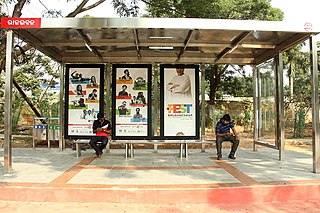
A bus stop is a place where buses stop for passengers to get on and off the bus. The construction of bus stops tends to reflect the level of usage, where stops at busy locations may have shelters, seating, and possibly electronic passenger information systems; less busy stops may use a simple pole and flag to mark the location. Bus stops are, in some locations, clustered together into transport hubs allowing interchange between routes from nearby stops and with other public transport modes to maximise convenience.

<span class="mw-page-title-main">Bus station</span> Bus facility larger than a bus stop

A bus station or a bus interchange is a structure where city buses or intercity buses stop to pick up and drop off passengers. While the term bus depot can also be used to refer to a bus station, it generally refers to a bus garage. A bus station is larger than a bus stop, which is usually simply a place on the roadside, where buses can stop. It may be intended as a terminal station for a number of routes, or as a transfer station where the routes continue.

<span class="mw-page-title-main">Berlin U-Bahn</span> Rapid transport system of Berlin, Germany

The Berlin U-Bahn is a rapid transit system in Berlin, the capital and largest city of Germany, and a major part of the city's public transport system. Together with the S-Bahn, a network of suburban train lines, and a tram network that operates mostly in the eastern parts of the city, it serves as the main means of transport in the capital.

<span class="mw-page-title-main">Passenger train toilet</span> Types of toilets in passenger trains

Many passenger trains have toilet facilities, often at the ends of carriages. Toilets suitable for wheelchair users are larger, and hence trains with such facilities may not have toilets in each carriage.

<span class="mw-page-title-main">Far North Line</span> A railway line in Scotland

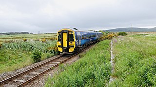
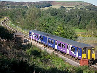
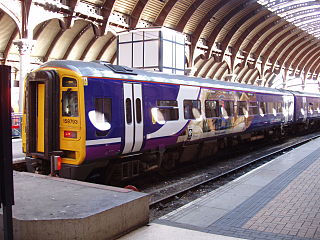
The Far North Line is a rural railway line entirely within the Highland area of Scotland, extending from Inverness to Thurso and Wick. As the name suggests, it is the northernmost railway in the United Kingdom. The line is entirely single-track, with only passing loops at some intermediate stations allowing trains to pass each other. In common with other railway lines in the Highlands and northern Lowlands, it is not electrified and all trains are diesel-powered.

<span class="mw-page-title-main">Island platform</span> Railway platform placed between two railway tracks

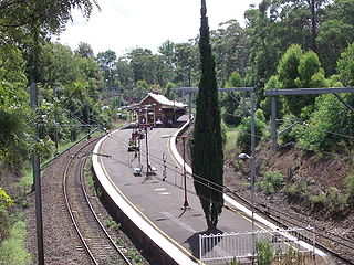
An island platform is a station layout arrangement where a single platform is positioned between two tracks within a railway station, tram stop or transitway interchange. Island platforms are popular on twin-track routes due to economic and land use reasons. They are also useful within larger stations where local and express services for the same direction of travel can be provided from opposite sides of the same platform thereby simplifying transfers between the two tracks. An alternative arrangement is to position side platforms on either side of the tracks. The historical use of island platforms depends greatly upon the location. In the United Kingdom the use of island platforms is relatively common when the railway line is in a cutting or raised on an embankment, as this makes it easier to provide access to the platform without walking across the tracks.

<span class="mw-page-title-main">Exton railway station</span> Railway station in the Devon, England

Exton railway station is a railway station serving the village of Exton in Devon, England. It is situated on the Avocet Line which runs between Exeter St Davids and Exmouth.

<i>Marshrutka</i> Fixed-route taxicab

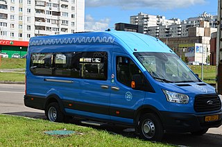
Marshrutka or marshrutnoe taksi or routed taxicab, are share taxis found in Eastern Europe and the republics of the former Soviet Union. Usually vans, they drive along set routes, depart only when all seats are filled, and may have higher fares than buses. Passengers can board a marshrutka anywhere along its route if there are seats available.

<span class="mw-page-title-main">Altnabreac railway station</span> Railway station in Highland, Scotland

Altnabreac railway station is a rural railway station in the Highland council area of Scotland. It serves the area of Altnabreac – a settlement in which the station itself is the main component – in the historic county of Caithness. The name Altnabreac derives from the Scots Gaelic Allt nam Breac, meaning "the stream of the trout".

<span class="mw-page-title-main">Entwistle railway station</span> Railway station in Lancashire, England

Entwistle railway station is 5+34 miles (9.3 km) north of Bolton and serves the village of Entwistle. It is also the closest station to Edgworth. Unlike nearby Bromley Cross the station lies outside the Transport for Greater Manchester boundary, meaning that passengers cannot take advantage of their special offers and ticketing. Owing to the remote location and low passenger numbers, Entwistle has been a request stop for several years, however since 21st May 2023, it is no longer a request stop, and all trains stop here. It is served by Northern services on the Ribble Valley Line towards Blackburn and Clitheroe in England.

<span class="mw-page-title-main">Request stop</span> Type of transport stop

In public transport, a request stop, flag stop, or whistle stop is a stop or station at which buses or trains, respectively, stop only on request; that is, only if there are passengers or freight to be picked up or dropped off. In this way, stops with low passenger counts can be incorporated into a route without introducing unnecessary delay. Vehicles may also save fuel by continuing through a station when there is no need to stop.

<span class="mw-page-title-main">Passenger information system</span>

A passenger information system, or passenger information display system, is an automated system for supplying users of public transport with information about the nature and the state of a public transport service through visual, voice or other media. It is also known as a customer information system or an operational information system. Among the information provided by such systems, a distinction can be drawn between:

<span class="mw-page-title-main">Paterson station</span> NJ Transit rail station

Paterson is a New Jersey Transit commuter railway station located on an elevated viaduct above Market Street in downtown Paterson, New Jersey. The railway through the station is double tracked, for north and south traffic on the NJT Main Line.

<span class="mw-page-title-main">Salak Selatan Komuter station</span>

The Salak Selatan Komuter station is a KTM Komuter train station located near the township of Salak South, Kuala Lumpur. Facing the Salak Expressway off Exit 2704 of the highway, the station is situated about 400 metres south of the old town of Salak South.

<span class="mw-page-title-main">Nishinomiya Station (JR West)</span> Railway station in Nishinomiya, Hyōgo Prefecture, Japan

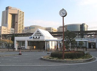
Nishinomiya Station is a passenger railway station located in the city of Nishinomiya, Hyōgo Prefecture, Japan. It is operated by the West Japan Railway Company. As a part of the JR West Urban Network, the following cards are accepted: J-Thru Card, ICOCA, Suica, Pasmo, and PiTaPa.

<span class="mw-page-title-main">Sannomiya Station (JR West)</span> Railway station in Kobe, Japan

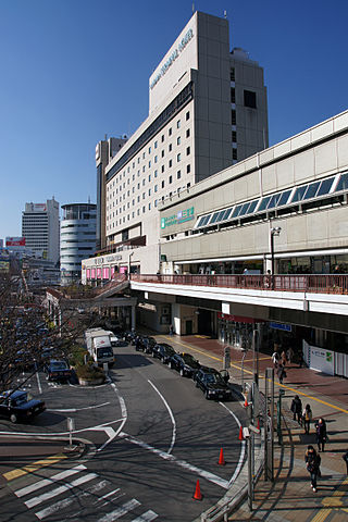
Sannomiya Station is a railway station in Nunobiki-chō, Chūō-ku, Kobe, Hyōgo Prefecture, and is operated by the West Japan Railway Company. The station is on the JR Kobe Line which runs between Osaka Station and Himeji Station; part of the Tōkaidō Main Line. As a part of the JR West Urban Network, the following IC cards are accepted: ICOCA, Suica, PiTaPa, TOICA, and SUGOCA.

<span class="mw-page-title-main">Yass Junction railway station</span> Railway station in New South Wales, Australia

Yass Junction railway station is a heritage-listed railway station on the Main South line in New South Wales, Australia. It serves the town of Yass. The station is not in the town itself but is located approximately four kilometres away near the Hume Highway. The station was listed on the New South Wales State Heritage Register on 2 April 1999.

<span class="mw-page-title-main">Regional rail</span> Inter-urban passenger train with frequent stops

Regional rail is a term used for passenger rail services that operate between towns and cities. These trains operate with more stops than inter-city rail, and unlike commuter rail, operate beyond the limits of urban areas, connecting smaller cities and towns.

<span class="mw-page-title-main">Train station</span> Railway facility for loading or unloading trains

A train station, railway station, railroad station, or railway depot is a railway facility where trains stop to load or unload passengers, freight, or both. It generally consists of at least one platform, one track, and a station building providing such ancillary services as ticket sales, waiting rooms, and baggage/freight service. If a station is on a single-track line, it often has a passing loop to facilitate traffic movements.

References

    1. "Tram stop locations - Douglas Bay Horse Tramway". douglashorsetramway.im. Retrieved 23 January 2022.