List of United Kingdom locations: The-Thh

Last updated

The United Kingdom Uk-map.svg
The United Kingdom

This is part of the list of United Kingdom locations: a gazetteer of place names in the United Kingdom showing each place's locality and geographical coordinates.

Contents

The

The A

LocationLocality Coordinates
(links to map & photo sources)
OS grid
reference
The Aird Highland 57°28′N4°36′W / 57.47°N 04.60°W / 57.47; -04.60 NH442455
Theakston North Yorkshire 54°16′N1°32′W / 54.26°N 01.54°W / 54.26; -01.54 SE3085
Thealby North Lincolnshire 53°38′N0°39′W / 53.64°N 00.65°W / 53.64; -00.65 SE8917
The Alders Staffordshire 52°38′N1°43′W / 52.63°N 01.72°W / 52.63; -01.72 SK1904
Theale Somerset 51°13′N2°46′W / 51.21°N 02.77°W / 51.21; -02.77 ST4646
Theale Berkshire 51°26′N1°05′W / 51.43°N 01.08°W / 51.43; -01.08 SU6471
The Arms Norfolk 52°32′N0°45′E / 52.54°N 00.75°E / 52.54; 00.75 TL8798
Thearne East Riding of Yorkshire 53°48′N0°22′W / 53.80°N 00.37°W / 53.80; -00.37 TA0736

The B

LocationLocality Coordinates
(links to map & photo sources)
OS grid
reference
The Bage Herefordshire 52°05′N3°02′W / 52.08°N 03.03°W / 52.08; -03.03 SO2943
The Bank Cheshire 53°07′N2°14′W / 53.11°N 02.24°W / 53.11; -02.24 SJ8457
The Banks Stockport 53°23′N2°02′W / 53.38°N 02.04°W / 53.38; -02.04 SJ9787
The Banks Wiltshire 51°31′N1°59′W / 51.51°N 01.98°W / 51.51; -01.98 SU0179
The Bar (Barmouth)Gwynedd 52°42′N4°03′W / 52.70°N 04.05°W / 52.70; -04.05 SH610141
The Bar (Caernarfon)Gwynedd 53°07′N4°20′W / 53.11°N 04.34°W / 53.11; -04.34 SH434595
The Bar Highland 57°37′N3°47′W / 57.62°N 03.79°W / 57.62; -03.79 NH931610
The Barony Cheshire 53°04′N2°31′W / 53.07°N 02.52°W / 53.07; -02.52 SJ6553
The Barony Orkney Islands 59°07′N3°19′W / 59.12°N 03.31°W / 59.12; -03.31 HY2527
The Barton Wiltshire 51°31′N1°54′W / 51.51°N 01.90°W / 51.51; -01.90 SU0779
The Batch South Gloucestershire 51°26′N2°29′W / 51.44°N 02.49°W / 51.44; -02.49 ST6672
The Beeches Gloucestershire 51°43′N1°57′W / 51.71°N 01.95°W / 51.71; -01.95 SP0302
The Bell Wigan 53°32′N2°41′W / 53.54°N 02.69°W / 53.54; -02.69 SD5405
The Bents Staffordshire 52°54′N1°58′W / 52.90°N 01.97°W / 52.90; -01.97 SK0234
Theberton Suffolk 52°13′N1°33′E / 52.22°N 01.55°E / 52.22; 01.55 TM4365
The Blythe Staffordshire 52°50′N1°56′W / 52.84°N 01.94°W / 52.84; -01.94 SK0428
The Bog Shropshire 52°34′N2°58′W / 52.56°N 02.96°W / 52.56; -02.96 SO3597
The Borough Southwark 51°29′N0°05′W / 51.49°N 00.09°W / 51.49; -00.09 TQ3279
The Bourne Surrey 51°11′N0°47′W / 51.18°N 00.79°W / 51.18; -00.79 SU8444
The Bourne Worcestershire 52°12′N2°02′W / 52.20°N 02.03°W / 52.20; -02.03 SO9856
The Brampton Staffordshire 53°01′N2°14′W / 53.01°N 02.23°W / 53.01; -02.23 SJ8446
The Brand Leicestershire 52°43′N1°13′W / 52.71°N 01.21°W / 52.71; -01.21 SK5313
The Bratch Staffordshire 52°32′N2°12′W / 52.53°N 02.20°W / 52.53; -02.20 SO8693
The Brents Kent 51°19′N0°53′E / 51.31°N 00.88°E / 51.31; 00.88 TR0161
The Bridge Dorset 50°55′N2°19′W / 50.91°N 02.31°W / 50.91; -02.31 ST7813
The Broad Herefordshire 52°14′N2°44′W / 52.23°N 02.74°W / 52.23; -02.74 SO4960
The Brook Suffolk 52°20′N1°03′E / 52.34°N 01.05°E / 52.34; 01.05 TM0876
The Brushes Derbyshire 53°16′N1°26′W / 53.27°N 01.44°W / 53.27; -01.44 SK3775
The Bryn Monmouthshire 51°46′N2°58′W / 51.77°N 02.97°W / 51.77; -02.97 SO3309
The Burf Worcestershire 52°18′N2°17′W / 52.30°N 02.28°W / 52.30; -02.28 SO8167
The Butts Hampshire 51°08′N0°59′W / 51.13°N 00.98°W / 51.13; -00.98 SU7138

The C

LocationLocality Coordinates
(links to map & photo sources)
OS grid
reference
The Camp Gloucestershire 51°46′N2°08′W / 51.77°N 02.13°W / 51.77; -02.13 SO9109
The Camp Hertfordshire 51°44′N0°19′W / 51.74°N 00.32°W / 51.74; -00.32 TL1606
The Cape Warwickshire 52°17′N1°36′W / 52.28°N 01.60°W / 52.28; -01.60 SP2765
The Carracks Cornwall 50°12′N5°32′W / 50.20°N 05.54°W / 50.20; -05.54 SW472401
The Chart Kent 51°14′N0°05′E / 51.24°N 00.09°E / 51.24; 00.09 TQ4652
The Chequer Wrexham 52°57′N2°46′W / 52.95°N 02.76°W / 52.95; -02.76 SJ4940
The Chuckery Walsall 52°35′N1°58′W / 52.58°N 01.97°W / 52.58; -01.97 SP0298
The City Buckinghamshire 51°39′N0°52′W / 51.65°N 00.87°W / 51.65; -00.87 SU7896
The Cleaver Herefordshire 51°57′N2°43′W / 51.95°N 02.71°W / 51.95; -02.71 SO5129
The Close West Sussex 50°49′N0°47′W / 50.82°N 00.79°W / 50.82; -00.79 SU8504
The Clubb Shetland Islands 60°22′N1°49′W / 60.36°N 01.82°W / 60.36; -01.82 HU097646
The Colony Oxfordshire 52°02′N1°30′W / 52.03°N 01.50°W / 52.03; -01.50 SP3437
The Common Bath and North East Somerset 51°22′N2°32′W / 51.36°N 02.54°W / 51.36; -02.54 ST6263
The Common Buckinghamshire 51°58′N0°53′W / 51.97°N 00.88°W / 51.97; -00.88 SP7731
The Common Dorset 50°53′N2°19′W / 50.88°N 02.31°W / 50.88; -02.31 ST7810
The Common Shropshire 52°50′N2°29′W / 52.83°N 02.49°W / 52.83; -02.49 SJ6727
The Common Suffolk 52°05′N1°05′E / 52.09°N 01.09°E / 52.09; 01.09 TM1248
The Common West Sussex 51°04′N0°20′W / 51.06°N 00.34°W / 51.06; -00.34 TQ1631
The Common (Brinkworth)Wiltshire 51°33′N1°58′W / 51.55°N 01.97°W / 51.55; -01.97 SU0284
The Common (Broughton Gifford)Wiltshire 51°22′N2°11′W / 51.37°N 02.18°W / 51.37; -02.18 ST8764
The Common (Winterslow)Wiltshire 51°05′N1°39′W / 51.08°N 01.65°W / 51.08; -01.65 SU2432
The Common Swansea 51°36′N4°10′W / 51.60°N 04.16°W / 51.60; -04.16 SS5092
The Corner Kent 51°08′N0°25′E / 51.14°N 00.42°E / 51.14; 00.42 TQ7041
The Corner Shropshire 52°28′N2°50′W / 52.47°N 02.84°W / 52.47; -02.84 SO4387
The Cot Monmouthshire 51°41′N2°43′W / 51.68°N 02.72°W / 51.68; -02.72 ST5099
The Crofts East Riding of Yorkshire 54°07′N0°09′W / 54.11°N 00.15°W / 54.11; -00.15 TA2170
The Cronk Isle of Man 54°19′N4°34′W / 54.32°N 04.56°W / 54.32; -04.56 SC3395
The Cross Hands Leicestershire 52°37′N1°31′W / 52.61°N 01.51°W / 52.61; -01.51 SK3302
The Cwm Monmouthshire 51°37′N2°47′W / 51.62°N 02.79°W / 51.62; -02.79 ST4592

Thed

LocationLocality Coordinates
(links to map & photo sources)
OS grid
reference
Theddingworth Leicestershire 52°27′N1°01′W / 52.45°N 01.02°W / 52.45; -01.02 SP6685
Theddlethorpe All Saints Lincolnshire 53°22′N0°11′E / 53.36°N 00.19°E / 53.36; 00.19 TF4688
Theddlethorpe St Helen Lincolnshire 53°22′N0°12′E / 53.36°N 00.20°E / 53.36; 00.20 TF4788
The Delves Walsall 52°34′N1°59′W / 52.56°N 01.98°W / 52.56; -01.98 SP0196
The Den North Ayrshire 55°43′N4°40′W / 55.72°N 04.67°W / 55.72; -04.67 NS3251
The Dene Durham 54°53′N1°50′W / 54.88°N 01.83°W / 54.88; -01.83 NZ1154
The Dene Hampshire 51°16′N1°27′W / 51.27°N 01.45°W / 51.27; -01.45 SU3853
The Down Kent 51°05′N0°23′E / 51.09°N 00.38°E / 51.09; 00.38 TQ6735
The Down Shropshire 52°30′N2°28′W / 52.50°N 02.47°W / 52.50; -02.47 SO6890
The Downs Surrey 51°06′N0°38′W / 51.10°N 00.64°W / 51.10; -00.64 SU9535
The Dunks Wrexham 53°02′N2°59′W / 53.04°N 02.98°W / 53.04; -02.98 SJ3450

The E

LocationLocality Coordinates
(links to map & photo sources)
OS grid
reference
The Eals Northumberland 55°09′N2°22′W / 55.15°N 02.37°W / 55.15; -02.37 NY7685
The Eaves Gloucestershire 51°45′N2°34′W / 51.75°N 02.56°W / 51.75; -02.56 SO6106

The F

LocationLocality Coordinates
(links to map & photo sources)
OS grid
reference
The Faither Shetland Islands 60°33′N1°32′W / 60.55°N 01.53°W / 60.55; -01.53 HU254852
The Fall Leeds 53°43′N1°32′W / 53.72°N 01.54°W / 53.72; -01.54 SE3025
The Fence Gloucestershire 51°44′N2°40′W / 51.74°N 02.66°W / 51.74; -02.66 SO5405
The Flat Gloucestershire 51°50′N2°22′W / 51.83°N 02.36°W / 51.83; -02.36 SO7515
The Flourish Derbyshire 52°56′N1°22′W / 52.93°N 01.37°W / 52.93; -01.37 SK4238
The Folly Hertfordshire 51°49′N0°19′W / 51.81°N 00.31°W / 51.81; -00.31 TL1614
The Folly South Gloucestershire 51°27′N2°22′W / 51.45°N 02.37°W / 51.45; -02.37 ST7473
The Fording Herefordshire 51°55′N2°31′W / 51.92°N 02.51°W / 51.92; -02.51 SO6525
The Forge Herefordshire 52°13′N2°58′W / 52.22°N 02.96°W / 52.22; -02.96 SO3459
The Forstal Kent 51°07′N0°55′E / 51.11°N 00.91°E / 51.11; 00.91 TR0439
The Forties Derbyshire 52°46′N1°29′W / 52.76°N 01.49°W / 52.76; -01.49 SK3419
The Four Alls Shropshire 52°52′N2°28′W / 52.87°N 02.47°W / 52.87; -02.47 SJ6831
The Fox Wiltshire 51°35′N1°51′W / 51.58°N 01.85°W / 51.58; -01.85 SU1087
The Foxholes Shropshire 52°25′N2°32′W / 52.41°N 02.53°W / 52.41; -02.53 SO6480
The Frenches Hampshire 50°59′N1°34′W / 50.99°N 01.57°W / 50.99; -01.57 SU3022
The Frythe Hertfordshire 51°49′N0°14′W / 51.81°N 00.23°W / 51.81; -00.23 TL2214

The G

LocationLocality Coordinates
(links to map & photo sources)
OS grid
reference
The Gibb Wiltshire 51°30′N2°14′W / 51.50°N 02.24°W / 51.50; -02.24 ST8379
The Glack Scottish Borders 55°37′N3°15′W / 55.62°N 03.25°W / 55.62; -03.25 NT2137
The Glen Western Isles 56°57′N7°29′W / 56.95°N 07.48°W / 56.95; -07.48 NL6798
The Gore Shropshire 52°26′N2°36′W / 52.43°N 02.60°W / 52.43; -02.60 SO5982
The Grange Norfolk 52°45′N1°10′E / 52.75°N 01.16°E / 52.75; 01.16 TG1422
The Grange North Yorkshire 54°21′N1°07′W / 54.35°N 01.12°W / 54.35; -01.12 SE5796
The Green Barnsley 53°31′N1°38′W / 53.51°N 01.63°W / 53.51; -01.63 SE2402
The Green Bedfordshire 51°50′N0°32′W / 51.84°N 00.54°W / 51.84; -00.54 TL0017
The Green Cambridgeshire 52°16′N0°07′W / 52.27°N 00.11°W / 52.27; -00.11 TL2966
The Green (Millom Without)Cumbria 54°14′N3°16′W / 54.24°N 03.27°W / 54.24; -03.27 SD1784
The Green (Lower Holker)Cumbria 54°10′N2°59′W / 54.17°N 02.98°W / 54.17; -02.98 SD3676
The Green Essex 51°50′N0°34′E / 51.84°N 00.56°E / 51.84; 00.56 TL7719
The Green Hampshire 51°03′N1°37′W / 51.05°N 01.61°W / 51.05; -01.61 SU2729
The Green Milton Keynes 52°04′N0°44′W / 52.07°N 00.73°W / 52.07; -00.73 SP8743
The Green (Wicklewood)Norfolk 52°34′N1°03′E / 52.56°N 01.05°E / 52.56; 01.05 TG0701
The Green (Stody)Norfolk 52°52′N1°04′E / 52.87°N 01.07°E / 52.87; 01.07 TG0735
The Green Northamptonshire 52°04′N0°50′W / 52.07°N 00.84°W / 52.07; -00.84 SP7942
The Green Oxfordshire 51°56′N1°19′W / 51.94°N 01.31°W / 51.94; -01.31 SP4728
The Green Shropshire 52°25′N3°02′W / 52.42°N 03.03°W / 52.42; -03.03 SO3081
The Green Warwickshire 52°13′N1°41′W / 52.22°N 01.69°W / 52.22; -01.69 SP2159
The Green Wiltshire 51°04′N2°12′W / 51.07°N 02.20°W / 51.07; -02.20 ST8631
The Grove Durham 54°50′N1°52′W / 54.84°N 01.86°W / 54.84; -01.86 NZ0950
The Grove Hertfordshire 51°40′N0°26′W / 51.67°N 00.43°W / 51.67; -00.43 TQ0898
The Grove (Wistanstow)Shropshire 52°27′N2°50′W / 52.45°N 02.84°W / 52.45; -02.84 SO4384
The Grove (Minsterley)Shropshire 52°38′N2°56′W / 52.63°N 02.93°W / 52.63; -02.93 SJ3705
The Grove Worcestershire 52°03′N2°12′W / 52.05°N 02.20°W / 52.05; -02.20 SO8640
The Gutter Worcestershire 52°23′N2°04′W / 52.39°N 02.07°W / 52.39; -02.07 SO9577
The Gutter Derbyshire 53°01′N1°28′W / 53.01°N 01.46°W / 53.01; -01.46 SK3647

The H

LocationLocality Coordinates
(links to map & photo sources)
OS grid
reference
The Haa Shetland Islands 60°19′N1°00′W / 60.32°N 01.00°W / 60.32; -01.00 HU550609
The Hacket South Gloucestershire 51°35′N2°30′W / 51.59°N 02.50°W / 51.59; -02.50 ST6589
The Hague Derbyshire 53°26′N2°00′W / 53.44°N 02.00°W / 53.44; -02.00 SK0094
The Hallands North Lincolnshire 53°40′N0°21′W / 53.66°N 00.35°W / 53.66; -00.35 TA0920
The Ham Wiltshire 51°16′N2°12′W / 51.26°N 02.20°W / 51.26; -02.20 ST8652
The Handfords Staffordshire 52°47′N2°11′W / 52.79°N 02.19°W / 52.79; -02.19 SJ8722
The Harbour Kent 51°12′N0°35′E / 51.20°N 00.58°E / 51.20; 00.58 TQ8148
The Haven West Sussex 51°03′N0°28′W / 51.05°N 00.46°W / 51.05; -00.46 TQ0830
The Hawthorns Staffordshire 53°00′N2°17′W / 53.00°N 02.29°W / 53.00; -02.29 SJ8045
The Headland Hartlepool 54°41′N1°11′W / 54.69°N 01.19°W / 54.69; -01.19 NZ5234
The Heath (Hevingham)Norfolk 52°44′N1°13′E / 52.74°N 01.22°E / 52.74; 01.22 TG1821
The Heath (North Norfolk)Norfolk 52°49′N0°52′E / 52.82°N 00.86°E / 52.82; 00.86 TF9329
The Heath (Buxton with Lammas)Norfolk 52°44′N1°18′E / 52.74°N 01.30°E / 52.74; 01.30 TG2321
The Heath Staffordshire 52°54′N1°53′W / 52.90°N 01.88°W / 52.90; -01.88 SK0834
The Heath Suffolk 51°59′N1°05′E / 51.98°N 01.08°E / 51.98; 01.08 TM1236
The Hem Shropshire 52°38′N2°25′W / 52.64°N 02.41°W / 52.64; -02.41 SJ7205
The Hendre Monmouthshire 51°49′N2°47′W / 51.82°N 02.79°W / 51.82; -02.79 SO4514
The Herberts The Vale Of Glamorgan 51°26′N3°27′W / 51.43°N 03.45°W / 51.43; -03.45 SS9972
The Hermitage Cambridgeshire 52°20′N0°02′E / 52.34°N 00.03°E / 52.34; 00.03 TL3974
The High Essex 51°46′N0°05′E / 51.77°N 00.08°E / 51.77; 00.08 TL4410
The Highlands East Sussex 50°51′N0°27′E / 50.85°N 00.45°E / 50.85; 00.45 TQ7309
The Hill Cumbria 54°14′N3°16′W / 54.23°N 03.27°W / 54.23; -03.27 SD1783
The Hobbins Shropshire 52°32′N2°23′W / 52.53°N 02.39°W / 52.53; -02.39 SO7393
The Hollands Staffordshire 53°07′N2°08′W / 53.12°N 02.13°W / 53.12; -02.13 SJ9159
The Hollies Nottinghamshire 53°03′N0°46′W / 53.05°N 00.77°W / 53.05; -00.77 SK8252
The Holmes City of Derby 52°55′N1°29′W / 52.92°N 01.48°W / 52.92; -01.48 SK3536
The Holt Berkshire 51°29′N0°50′W / 51.49°N 00.84°W / 51.49; -00.84 SU8078
The Hook Worcestershire 52°03′N2°16′W / 52.05°N 02.26°W / 52.05; -02.26 SO8240
The Hope Shropshire 52°23′N2°43′W / 52.39°N 02.72°W / 52.39; -02.72 SO5178
The Howe Cumbria 54°17′N2°50′W / 54.28°N 02.84°W / 54.28; -02.84 SD4588
The Humbers Shropshire 52°43′N2°28′W / 52.72°N 02.46°W / 52.72; -02.46 SJ6914
The Hundred Herefordshire 52°16′N2°42′W / 52.27°N 02.70°W / 52.27; -02.70 SO5264
The Hyde Brent 51°34′N0°15′W / 51.57°N 00.25°W / 51.57; -00.25 TQ2188
The Hythe Essex 51°52′N0°55′E / 51.87°N 00.91°E / 51.87; 00.91 TM0124
The Hyde Worcestershire 52°03′N2°14′W / 52.05°N 02.24°W / 52.05; -02.24 SO8340

The I

LocationLocality Coordinates
(links to map & photo sources)
OS grid
reference
The Inch City of Edinburgh 55°55′N3°10′W / 55.91°N 03.16°W / 55.91; -03.16 NT2770

The K

LocationLocality Coordinates
(links to map & photo sources)
OS grid
reference
The Knab Swansea 51°34′N3°59′W / 51.56°N 03.99°W / 51.56; -03.99 SS6287
The Knap The Vale Of Glamorgan 51°23′N3°18′W / 51.38°N 03.30°W / 51.38; -03.30 ST0966
The Knapp Herefordshire 52°11′N2°31′W / 52.18°N 02.51°W / 52.18; -02.51 SO6554
The Knapp South Gloucestershire 51°37′N2°30′W / 51.61°N 02.50°W / 51.61; -02.50 ST6591
The Knowle Sandwell 52°29′N2°04′W / 52.48°N 02.06°W / 52.48; -02.06 SO9687

The L

LocationLocality Coordinates
(links to map & photo sources)
OS grid
reference
The Laches Staffordshire 52°40′N2°07′W / 52.66°N 02.11°W / 52.66; -02.11 SJ9207
The Lake Dumfries and Galloway 54°48′N4°03′W / 54.80°N 04.05°W / 54.80; -04.05 NX6847
The Lakes Worcestershire 52°22′N2°20′W / 52.37°N 02.33°W / 52.37; -02.33 SO7775
The Lawe South Tyneside 54°59′N1°26′W / 54.99°N 01.43°W / 54.99; -01.43 NZ3667
The Lawns East Riding of Yorkshire 53°47′N0°26′W / 53.78°N 00.43°W / 53.78; -00.43 TA0333
The Leacon Kent 51°04′N0°49′E / 51.06°N 00.82°E / 51.06; 00.82 TQ9833
The Leath Shropshire 52°29′N2°37′W / 52.49°N 02.62°W / 52.49; -02.62 SO5889
The Lee Buckinghamshire 51°43′N0°41′W / 51.72°N 00.69°W / 51.72; -00.69 SP9004
The Lees Kent 51°13′N0°52′E / 51.21°N 00.86°E / 51.21; 00.86 TR0050
The Leigh Gloucestershire 51°56′N2°11′W / 51.93°N 02.19°W / 51.93; -02.19 SO8726
The Leys Staffordshire 52°38′N1°42′W / 52.63°N 01.70°W / 52.63; -01.70 SK2004
The Lhen Isle of Man 54°22′N4°29′W / 54.37°N 04.49°W / 54.37; -04.49 NX3801
The Ling Norfolk 52°32′N1°23′E / 52.53°N 01.38°E / 52.53; 01.38 TM3098
The Lings Doncaster 53°34′N1°01′W / 53.56°N 01.01°W / 53.56; -01.01 SE6508
The Lings Norfolk 52°37′N0°59′E / 52.61°N 00.99°E / 52.61; 00.99 TG0306
The Linleys Wiltshire 51°25′N2°11′W / 51.41°N 02.18°W / 51.41; -02.18 ST8768
Thelnetham Suffolk 52°22′N0°57′E / 52.36°N 00.95°E / 52.36; 00.95 TM0178
The Lunt Wolverhampton 52°34′N2°04′W / 52.56°N 02.06°W / 52.56; -02.06 SO9696
Thelveton Norfolk 52°23′N1°10′E / 52.38°N 01.17°E / 52.38; 01.17 TM1681
Thelwall Cheshire 53°22′N2°32′W / 53.37°N 02.54°W / 53.37; -02.54 SJ6487

The M

LocationLocality Coordinates
(links to map & photo sources)
OS grid
reference
The Manor West Sussex 50°49′N0°48′W / 50.82°N 00.80°W / 50.82; -00.80 SU8404
The Marsh Cheshire 53°09′N2°14′W / 53.15°N 02.24°W / 53.15; -02.24 SJ8462
The Marsh Herefordshire 52°13′N2°44′W / 52.22°N 02.74°W / 52.22; -02.74 SO4959
The Marsh Powys 52°34′N3°01′W / 52.56°N 03.01°W / 52.56; -03.01 SO3197
The Marsh Shropshire 52°49′N2°28′W / 52.82°N 02.46°W / 52.82; -02.46 SJ6925
The Marsh Staffordshire 52°50′N2°14′W / 52.83°N 02.23°W / 52.83; -02.23 SJ8426
The Marsh (Wortham)Suffolk 52°21′N1°03′E / 52.35°N 01.05°E / 52.35; 01.05 TM0877
The Marsh (Thrandeston)Suffolk 52°20′N1°05′E / 52.34°N 01.09°E / 52.34; 01.09 TM1176
Themelthorpe Norfolk 52°46′N1°02′E / 52.77°N 01.03°E / 52.77; 01.03 TG0524
The Middles Durham 54°51′N1°41′W / 54.85°N 01.68°W / 54.85; -01.68 NZ2051
The Mint Hampshire 51°02′N0°53′W / 51.04°N 00.88°W / 51.04; -00.88 SU7828
The Model Village Warwickshire 52°16′N1°24′W / 52.27°N 01.40°W / 52.27; -01.40 SP4164
The Moor Kent 51°02′N0°29′E / 51.03°N 00.49°E / 51.03; 00.49 TQ7529
The Moor Flintshire 53°11′N3°01′W / 53.18°N 03.01°W / 53.18; -03.01 SJ3266
The Mooragh Isle of Man 54°19′N4°23′W / 54.31°N 04.38°W / 54.31; -04.38 SC4594
The Moors Herefordshire 51°59′N2°40′W / 51.98°N 02.67°W / 51.98; -02.67 SO5432
The Mount Dorset 50°46′N2°44′W / 50.76°N 02.73°W / 50.76; -02.73 SY4896
The Mount Berkshire 51°26′N0°58′W / 51.44°N 00.96°W / 51.44; -00.96 SU7272
The Mount Hampshire 51°20′N1°23′W / 51.34°N 01.38°W / 51.34; -01.38 SU4361
The Mumbles Swansea 51°34′N4°00′W / 51.56°N 04.00°W / 51.56; -04.00 SS6187
The Murray South Lanarkshire 55°45′N4°11′W / 55.75°N 04.18°W / 55.75; -04.18 NS6353
The Mythe Gloucestershire 52°00′N2°10′W / 52.00°N 02.16°W / 52.00; -02.16 SO8934

The N

LocationLocality Coordinates
(links to map & photo sources)
OS grid
reference
The Nant Wrexham 53°02′N3°04′W / 53.04°N 03.07°W / 53.04; -03.07 SJ2850
The Naze Essex 51°52′N1°17′E / 51.87°N 01.28°E / 51.87; 01.28 TM263244
The Ness Shetland Islands 60°08′N2°04′W / 60.14°N 02.06°W / 60.14; -02.06 HT967405
The Neuk Aberdeenshire 57°04′N2°26′W / 57.06°N 02.44°W / 57.06; -02.44 NO7397
The Nev Shetland Islands 60°47′N0°47′W / 60.78°N 00.78°W / 60.78; -00.78 HP660118
Thenford Northamptonshire 52°04′N1°15′W / 52.06°N 01.25°W / 52.06; -01.25 SP5141
The Node Hertfordshire 51°52′N0°14′W / 51.86°N 00.24°W / 51.86; -00.24 TL2120
The Nook (Prees Green)Shropshire 52°52′N2°39′W / 52.86°N 02.65°W / 52.86; -02.65 SJ5630
The Nook (Child's Ercall)Shropshire 52°49′N2°29′W / 52.81°N 02.49°W / 52.81; -02.49 SJ6724
The North Monmouthshire 51°45′N2°41′W / 51.75°N 02.69°W / 51.75; -02.69 SO5206
The Noup Shetland Islands 60°50′N0°50′W / 60.83°N 00.84°W / 60.83; -00.84 HP631177

The O

LocationLocality Coordinates
(links to map & photo sources)
OS grid
reference
Theobald's Green Wiltshire 51°25′N1°58′W / 51.42°N 01.97°W / 51.42; -01.97 SU0269
The Oval Bath and North East Somerset 51°22′N2°23′W / 51.36°N 02.38°W / 51.36; -02.38 ST7363

The P

LocationLocality Coordinates
(links to map & photo sources)
OS grid
reference
The Park Gloucestershire 51°53′N2°05′W / 51.88°N 02.08°W / 51.88; -02.08 SO9421
The Parks Doncaster 53°34′N1°02′W / 53.57°N 01.03°W / 53.57; -01.03 SE6409
The Pitts Wiltshire 51°02′N1°54′W / 51.03°N 01.90°W / 51.03; -01.90 SU0726
The Platt Oxfordshire 51°42′N1°08′W / 51.70°N 01.14°W / 51.70; -01.14 SP5901
The Pludds Gloucestershire 51°50′N2°34′W / 51.84°N 02.56°W / 51.84; -02.56 SO6116
The Point Devon 50°37′N3°25′W / 50.61°N 03.42°W / 50.61; -03.42 SX9980
The Pole of Itlaw Aberdeenshire 57°35′N2°33′W / 57.59°N 02.55°W / 57.59; -02.55 NJ6756
The Port of Felixstowe Suffolk 51°56′N1°19′E / 51.94°N 01.31°E / 51.94; 01.31 TM2833
The Potteries City of Stoke-on-Trent 53°01′N2°11′W / 53.01°N 02.18°W / 53.01; -02.18 SJ8846
The Pound Gloucestershire 51°58′N2°26′W / 51.97°N 02.43°W / 51.97; -02.43 SO7031

The Q

LocationLocality Coordinates
(links to map & photo sources)
OS grid
reference
The Quarry Gloucestershire 51°41′N2°23′W / 51.68°N 02.39°W / 51.68; -02.39 ST7399
The Quarry Shropshire 52°42′N2°46′W / 52.70°N 02.77°W / 52.70; -02.77 SJ4812
The Quarter (Smarden)Kent 51°10′N0°41′E / 51.16°N 00.68°E / 51.16; 00.68 TQ8844
The Quarter (Tenterden)Kent 51°03′N0°41′E / 51.05°N 00.68°E / 51.05; 00.68 TQ8832

The R

LocationLocality Coordinates
(links to map & photo sources)
OS grid
reference
The Rampings Worcestershire 52°00′N2°13′W / 52.00°N 02.21°W / 52.00; -02.21 SO8534
The Rectory Lincolnshire 52°40′N0°19′W / 52.67°N 00.32°W / 52.67; -00.32 TF1310
The Reddings Gloucestershire 51°53′N2°08′W / 51.88°N 02.14°W / 51.88; -02.14 SO9021
Therfield Hertfordshire 52°01′N0°04′W / 52.01°N 00.06°W / 52.01; -00.06 TL3337
The Rhos Pembrokeshire 51°47′N4°54′W / 51.78°N 04.90°W / 51.78; -04.90 SN0014
The Rhydd Herefordshire 51°59′N2°47′W / 51.99°N 02.78°W / 51.99; -02.78 SO4633
The Riddle Herefordshire 52°15′N2°46′W / 52.25°N 02.77°W / 52.25; -02.77 SO4762
The Ridge Wiltshire 51°25′N2°11′W / 51.41°N 02.18°W / 51.41; -02.18 ST8768
The Ridges Berkshire 51°22′N0°51′W / 51.36°N 00.85°W / 51.36; -00.85 SU8063
The Ridgeway Hertfordshire 51°43′N0°08′W / 51.71°N 00.14°W / 51.71; -00.14 TL2803
The Riding Northumberland 54°59′N2°07′W / 54.98°N 02.11°W / 54.98; -02.11 NY9366
The Riggs Scottish Borders 55°35′N3°04′W / 55.59°N 03.06°W / 55.59; -03.06 NT3334
The Rink Scottish Borders 55°34′N2°49′W / 55.57°N 02.82°W / 55.57; -02.82 NT4832
The Rise Berkshire 51°23′N0°39′W / 51.39°N 00.65°W / 51.39; -00.65 SU9467
The Rock Shropshire 52°40′N2°28′W / 52.67°N 02.47°W / 52.67; -02.47 SJ6809
The Rocks South Gloucestershire 51°33′N2°24′W / 51.55°N 02.40°W / 51.55; -02.40 ST7284
The Rocks Kent 51°16′N0°26′E / 51.27°N 00.43°E / 51.27; 00.43 TQ7056
The Roe Denbighshire 53°15′N3°27′W / 53.25°N 03.45°W / 53.25; -03.45 SJ0374
The Rookery Hertfordshire 51°38′N0°25′W / 51.63°N 00.41°W / 51.63; -00.41 TQ1094
The Rookery Staffordshire 53°05′N2°13′W / 53.09°N 02.22°W / 53.09; -02.22 SJ8555
The Row Lancashire 54°10′N2°49′W / 54.16°N 02.81°W / 54.16; -02.81 SD4775
The Rowe Staffordshire 52°56′N2°16′W / 52.93°N 02.26°W / 52.93; -02.26 SJ8238
The Ryde Hertfordshire 51°46′N0°13′W / 51.76°N 00.21°W / 51.76; -00.21 TL2309

The S

LocationLocality Coordinates
(links to map & photo sources)
OS grid
reference
The Sale Staffordshire 52°43′N1°46′W / 52.72°N 01.77°W / 52.72; -01.77 SK1514
The Sands Surrey 51°12′N0°44′W / 51.20°N 00.74°W / 51.20; -00.74 SU8846
The Scarr Gloucestershire 51°56′N2°24′W / 51.94°N 02.40°W / 51.94; -02.40 SO7227
The Shoe Wiltshire 51°28′N2°17′W / 51.46°N 02.28°W / 51.46; -02.28 ST8074
The Shruggs Staffordshire 52°52′N2°05′W / 52.86°N 02.09°W / 52.86; -02.09 SJ9430
The Skerries Isle of Anglesey 53°25′N4°36′W / 53.42°N 04.60°W / 53.42; -04.60 SH268954
The Slack Durham 54°37′N1°50′W / 54.62°N 01.83°W / 54.62; -01.83 NZ1125
The Slade Berkshire 51°25′N1°14′W / 51.41°N 01.23°W / 51.41; -01.23 SU5369
The Smeeth Norfolk 52°40′N0°14′E / 52.66°N 00.24°E / 52.66; 00.24 TF5210
The Smithies Shropshire 52°34′N2°29′W / 52.57°N 02.48°W / 52.57; -02.48 SO6797
The Snap Shetland Islands 60°34′N0°47′W / 60.57°N 00.79°W / 60.57; -00.79 HU659885
The Spa Wiltshire 51°21′N2°08′W / 51.35°N 02.13°W / 51.35; -02.13 ST9162
The Spring Warwickshire 52°21′N1°35′W / 52.35°N 01.59°W / 52.35; -01.59 SP2873
The Square Torfaen 51°39′N3°03′W / 51.65°N 03.05°W / 51.65; -03.05 ST2796
The Stocks Kent 51°01′N0°43′E / 51.01°N 00.72°E / 51.01; 00.72 TQ9127
The Stocks Wiltshire 51°20′N2°07′W / 51.33°N 02.11°W / 51.33; -02.11 ST9260
The Straits Dudley 52°31′N2°08′W / 52.52°N 02.14°W / 52.52; -02.14 SO9092
The Straits Hampshire 51°08′N0°53′W / 51.13°N 00.88°W / 51.13; -00.88 SU7838
The Strand Wiltshire 51°20′10″N2°07′05″W / 51.336°N 02.118°W / 51.336; -02.118 ST919597
The Swillett Hertfordshire 51°38′N0°31′W / 51.64°N 00.52°W / 51.64; -00.52 TQ0295
The Sydnall Shropshire 52°52′N2°28′W / 52.86°N 02.47°W / 52.86; -02.47 SJ6830

Thet

LocationLocality Coordinates
(links to map & photo sources)
OS grid
reference
Thetford Norfolk 52°25′N0°44′E / 52.41°N 00.74°E / 52.41; 00.74 TL8783
Thetford Lincolnshire 52°43′N0°21′W / 52.71°N 00.35°W / 52.71; -00.35 TF1114
The Thrift Cambridgeshire 52°02′N0°05′W / 52.03°N 00.09°W / 52.03; -00.09 TL3139
The Throat Berkshire 51°23′N0°51′W / 51.38°N 00.85°W / 51.38; -00.85 SU8066
Thethwaite Cumbria 54°47′N2°59′W / 54.78°N 02.98°W / 54.78; -02.98 NY3744
The Toft Staffordshire 52°45′N2°08′W / 52.75°N 02.14°W / 52.75; -02.14 SJ9018
The Towans Cornwall 50°11′N5°26′W / 50.19°N 05.43°W / 50.19; -05.43 SW5538
The Town Isles of Scilly 49°57′N6°22′W / 49.95°N 06.36°W / 49.95; -06.36 SV8715
The Twittocks Gloucestershire 52°02′N2°10′W / 52.03°N 02.17°W / 52.03; -02.17 SO8837
The Tynings Gloucestershire 51°52′N2°07′W / 51.86°N 02.11°W / 51.86; -02.11 SO9219

The V

LocationLocality Coordinates
(links to map & photo sources)
OS grid
reference
The Vale Birmingham 52°27′N1°55′W / 52.45°N 01.92°W / 52.45; -01.92 SP0584
The Valley Kent 51°14′N0°47′E / 51.24°N 00.79°E / 51.24; 00.79 TQ9553
The Valley Cheshire 53°05′N2°28′W / 53.09°N 02.46°W / 53.09; -02.46 SJ6955
The Valley Leicestershire 52°46′N0°56′W / 52.76°N 00.94°W / 52.76; -00.94 SK7119
The Valley Pembrokeshire 51°43′N4°43′W / 51.71°N 04.72°W / 51.71; -04.72 SN1205
The Vauld Herefordshire 52°08′N2°41′W / 52.13°N 02.68°W / 52.13; -02.68 SO5349
The Village Berkshire 51°26′N0°38′W / 51.43°N 00.63°W / 51.43; -00.63 SU9572
The Village Dudley 52°29′N2°10′W / 52.49°N 02.16°W / 52.49; -02.16 SO8989
The Village City of Newport 51°36′N2°57′W / 51.60°N 02.95°W / 51.60; -02.95 ST3490

The W

LocationLocality Coordinates
(links to map & photo sources)
OS grid
reference
The Walshes Worcestershire 52°19′N2°17′W / 52.32°N 02.29°W / 52.32; -02.29 SO8070
The Warren Kent 51°10′N0°50′E / 51.16°N 00.84°E / 51.16; 00.84 TQ9944
The Warren Wiltshire 51°23′N1°39′W / 51.38°N 01.65°W / 51.38; -01.65 SU2465
The Waterwheel Shropshire 52°37′N2°56′W / 52.61°N 02.94°W / 52.61; -02.94 SJ3602
The Weaven Herefordshire 51°58′N2°40′W / 51.97°N 02.67°W / 51.97; -02.67 SO5431
The Wells Surrey 51°19′N0°17′W / 51.32°N 00.29°W / 51.32; -00.29 TQ1960
The Wern Wrexham 53°02′N3°05′W / 53.04°N 03.09°W / 53.04; -03.09 SJ2750
The Willows North East Lincolnshire 53°34′N0°07′W / 53.56°N 00.12°W / 53.56; -00.12 TA2409
The Wood (Maesbrook)Shropshire 52°47′N3°02′W / 52.79°N 03.03°W / 52.79; -03.03 SJ3022
The Wood (Loppington)Shropshire 52°50′N2°49′W / 52.84°N 02.81°W / 52.84; -02.81 SJ4528
The Woodlands Leicestershire 52°33′N1°02′W / 52.55°N 01.04°W / 52.55; -01.04 SP6596
The Woodlands (Holbrook)Suffolk 51°59′N1°08′E / 51.98°N 01.14°E / 51.98; 01.14 TM1637
The Woodlands (Raydon)Suffolk 52°01′N0°59′E / 52.02°N 00.98°E / 52.02; 00.98 TM0540
The Woods Sandwell 52°33′N2°00′W / 52.55°N 02.00°W / 52.55; -02.00 SP0095
The Wrangle Somerset 51°18′N2°40′W / 51.30°N 02.66°W / 51.30; -02.66 ST5456
The Wrythe Sutton 51°22′N0°10′W / 51.37°N 00.17°W / 51.37; -00.17 TQ2765
The Wyke Shropshire 52°39′N2°24′W / 52.65°N 02.40°W / 52.65; -02.40 SJ7306
The Wymm Herefordshire 52°07′N2°41′W / 52.11°N 02.68°W / 52.11; -02.68 SO5347

They

LocationLocality Coordinates
(links to map & photo sources)
OS grid
reference
Theydon Bois Essex 51°40′N0°05′E / 51.67°N 00.09°E / 51.67; 00.09 TQ4599
Theydon Garnon Essex 51°40′N0°07′E / 51.67°N 00.12°E / 51.67; 00.12 TQ4799
Theydon Mount Essex 51°40′N0°09′E / 51.67°N 00.15°E / 51.67; 00.15 TQ4999
The Yeld Shropshire 52°26′N2°38′W / 52.44°N 02.63°W / 52.44; -02.63 SO5783

Related Research Articles

Britain most often refers to:

<span class="mw-page-title-main">Parliament of the United Kingdom</span> Legislative body in the United Kingdom

The Parliament of the United Kingdom of Great Britain and Northern Ireland is the supreme legislative body of the United Kingdom, and may also legislate for the Crown Dependencies and the British Overseas Territories. It meets at the Palace of Westminster in London. Parliament possesses legislative supremacy and thereby holds ultimate power over all other political bodies in the United Kingdom and the Overseas Territories. While Parliament is bicameral, it has three parts: the sovereign (King-in-Parliament), the House of Lords, and the House of Commons. In theory, power is officially vested in the King-in-Parliament. However, the Crown normally acts on the advice of the prime minister, and the powers of the House of Lords are limited to only delaying legislation; thus power is de facto vested in the House of Commons.

June is the sixth month of the year in the Julian and Gregorian calendars. Its length is 30 days. June contains the summer solstice in the Northern Hemisphere, the day with the most daylight hours, and the winter solstice in the Southern Hemisphere, the day with the fewest daylight hours. June in the Northern Hemisphere is the seasonal equivalent to December in the Southern Hemisphere and vice versa. In the Northern Hemisphere, the beginning of the traditional astronomical summer is 21 June. In the Southern Hemisphere, meteorological winter begins on 1 June.

<span class="mw-page-title-main">Prime Minister of the United Kingdom</span> Head of government in the United Kingdom

The prime minister of the United Kingdom is the head of government of the United Kingdom. The prime minister advises the sovereign on the exercise of much of the royal prerogative, chairs the Cabinet and selects its ministers. As modern prime ministers hold office by virtue of their ability to command the confidence of the House of Commons, they sit as members of Parliament. The current prime minister is Rishi Sunak of the Conservative Party, who assumed the office on 25 October 2022.

<span class="mw-page-title-main">Primary school</span> School for children

A primary school, elementary school, or grade school is a school for primary education of children who are 4 to 10 years of age. Primary schooling follows preschool and precedes secondary schooling.

<span class="mw-page-title-main">United Kingdom</span> Country in Northwestern Europe

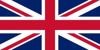
The United Kingdom of Great Britain and Northern Ireland, commonly known as the United Kingdom (UK) or Britain, is a country in Northwestern Europe, off the north-western coast of the continental mainland. It comprises England, Scotland, Wales, and Northern Ireland. It includes the island of Great Britain, the north-eastern part of the island of Ireland, and most of the smaller islands within the British Isles. Northern Ireland shares a land border with the Republic of Ireland; otherwise, the United Kingdom is surrounded by the Atlantic Ocean, the North Sea, the English Channel, the Celtic Sea, and the Irish Sea. The total area of the United Kingdom is 94,354 square miles (244,376 km2), with an estimated population of just over 67 million people in 2021.

The Peerage of Ireland consists of those titles of nobility created by the English monarchs in their capacity as Lord or King of Ireland, or later by monarchs of the United Kingdom of Great Britain and Ireland. It is one of the five divisions of Peerages in the United Kingdom. The creation of such titles came to an end in the 19th century. The ranks of the Irish peerage are duke, marquess, earl, viscount and baron. As of 2016, there were 135 titles in the Peerage of Ireland extant: two dukedoms, ten marquessates, 43 earldoms, 28 viscountcies, and 52 baronies. However, these titles have no official recognition in the Republic of Ireland, with Article 40.2 of the Constitution of Ireland forbidding the state conferring titles of nobility and stating that an Irish citizen may not accept titles of nobility or honour except with the prior approval of the Irish government.

<span class="mw-page-title-main">October 1974 United Kingdom general election</span>

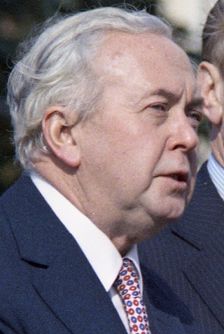
The October 1974 United Kingdom general election took place on Thursday 10 October 1974 to elect 635 members of the British House of Commons. It was the second general election held that year; the first year that two general elections were held in the same year since 1910; and the first time that two general elections were held less than a year apart from each other since the 1923 and 1924 elections, which took place 10 months apart. The election resulted in the Labour Party, led by Prime Minister Harold Wilson, winning a bare majority of three seats. That enabled the remainder of the Labour government to take place, but it saw a gradual loss of its majority.

<span class="mw-page-title-main">December 1910 United Kingdom general election</span>

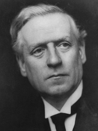
The December 1910 United Kingdom general election was held from 3 to 19 December. It was the last general election to be held over several days and the last to be held before the First World War.

<span class="mw-page-title-main">Lists of places in Wales</span>

These are lists of places in Wales.

<span class="mw-page-title-main">Constituencies of the Parliament of the United Kingdom</span> Electoral divisions of the parliament of the United Kingdom

The Parliament of the United Kingdom currently has 650 parliamentary constituencies across the constituent countries, each electing a single member of parliament (MP) to the House of Commons by the plurality voting system, ordinarily every five years. Voting last took place in all 650 of those constituencies at the United Kingdom general election on 12 December 2019.

<span class="mw-page-title-main">Member of Parliament (United Kingdom)</span> Representative in the House of Commons

In the United Kingdom, a member of Parliament (MP) is an individual elected to serve in the House of Commons, the lower house of the Parliament of the United Kingdom.

<span class="mw-page-title-main">Unitary authorities of England</span> Local government in some parts of England

The unitary authorities of England are a type of local authority responsible for all local government services in an area. They combine the functions of a non-metropolitan county council and a non-metropolitan district council, which elsewhere in England provide two tiers of local government.

<span class="mw-page-title-main">Kingdom of Portugal</span> Kingdom in Southwestern Europe (1139–1910)

The Kingdom of Portugal was a monarchy in the western Iberian Peninsula and the predecessor of the modern Portuguese Republic. Existing to various extents between 1139 and 1910, it was also known as the Kingdom of Portugal and the Algarves after 1415, and as the United Kingdom of Portugal, Brazil and the Algarves between 1815 and 1822. The name is also often applied to the Portuguese Empire, the realm's overseas colonies.

<span class="mw-page-title-main">United Kingdom in the Eurovision Song Contest</span>

The United Kingdom has participated in the Eurovision Song Contest 65 times. It first took part in the second contest in 1957 and has entered every year since 1959. Along with Sweden and the Netherlands, the UK is one of only three countries with Eurovision victories in four different decades. It is one of the "Big Five" countries, along with France, Germany, Italy and Spain, that are automatically prequalified for the final each year as they are the biggest financial contributors to the European Broadcasting Union (EBU). The British national broadcaster, the BBC, broadcasts the event and has, on multiple occasions, organised different national selection processes to choose the British entry. The United Kingdom has won the Eurovision Song Contest five times, and has finished as runner-up on a record sixteen occasions. The UK has hosted the contest a record nine times, four times in London and once each in Edinburgh (1972), Brighton (1974), Harrogate (1982), Birmingham (1998), and Liverpool (2023).

<span class="mw-page-title-main">Countries of the United Kingdom</span> Component parts of the UK since 1922

Since 1922, the United Kingdom has been made up of four countries: England, Scotland, Wales and Northern Ireland. The UK Prime Minister's website has used the phrase "countries within a country" to describe the United Kingdom. Some statistical summaries, such as those for the twelve NUTS 1 regions of the UK, refer to Northern Ireland, Scotland, and Wales as "regions". With regard to Northern Ireland, Scotland and Wales particularly, the descriptive name one uses "can be controversial, with the choice often revealing one's political preferences".