List of bridges on the National Register of Historic Places in Arizona

Last updated

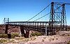
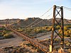
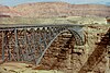
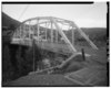
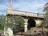
This is a list of bridges and tunnels on the National Register of Historic Places in the U.S. state of Arizona. [1]

NameImageBuiltListedLocationCountyType
Alchesay Canyon Bridge Arizona - Alchesay Canyon Bridge - 2.jpg 1904, 19051988-09-30 Roosevelt
33°40′5″N111°9′30″W / 33.66806°N 111.15833°W / 33.66806; -111.15833 (Alchesay Canyon Bridge)
Maricopa Filled spandrel arch
Allentown Bridge AllentownBridge-1.jpg 19231988-09-30 Houck
35°16′51″N109°9′16″W / 35.28083°N 109.15444°W / 35.28083; -109.15444 (Allentown Bridge)
Apache Pratt deck truss
Antelope Hill Highway Bridge 1915, 19201979-06-28 Tacna
32°43′8″N114°0′43″W / 32.71889°N 114.01194°W / 32.71889; -114.01194 (Antelope Hill Highway Bridge)
Yuma Concrete girder
Black Gap Bridge Black Gap bridge (Greenlee Co, AZ) from S 1.JPG 19211988-09-30 Clifton
32°56′47″N109°19′7″W / 32.94639°N 109.31861°W / 32.94639; -109.31861 (Black Gap Bridge)
Greenlee Concrete slab
Black River Bridge 1912, 19291988-09-30Near Carrizo
33°42′47″N110°12′42″W / 33.71299°N 110.21179°W / 33.71299; -110.21179 (Black River Bridge)
Gila Warren deck truss
Boulder Creek Bridge Torilla Flat-Boulder Creek Bridge-1937-12.JPG 19371989-03-31 Tortilla Flat
33°32′1″N111°25′23″W / 33.53361°N 111.42306°W / 33.53361; -111.42306 (Boulder Creek Bridge)
Maricopa
Broadway Bridge Clarkdale-Broadway Bridge-1917-2.jpg 19171988-09-30 Clarkdale
34°46′27″N112°3′19″W / 34.77417°N 112.05528°W / 34.77417; -112.05528 (Broadway Bridge)
Yavapai Skewed concrete slab
Cameron Suspension Bridge Cameron Suspension Bridge.jpg 19111986-06-05 Cameron
35°52′38″N111°24′40″W / 35.87722°N 111.41111°W / 35.87722; -111.41111 (Cameron Suspension Bridge)
Coconino Suspension-truss hybrid
Canyon Diablo Bridge Canyon Diablo Bridge.jpg 1914, 1915, ca. 19301988-09-30 Winona
35°6′56″N111°5′41″W / 35.11556°N 111.09472°W / 35.11556; -111.09472 (Canyon Diablo Bridge)
Coconino Steel arch
Canyon Padre Bridge 1913, 19141988-09-30 Flagstaff
35°9′44″N111°17′12″W / 35.16222°N 111.28667°W / 35.16222; -111.28667 (Canyon Padre Bridge)
Coconino Concrete Luten arch
Cedar Canyon Bridge Cedar creek bridge.jpg 19371988-09-30 Show Low
34°3′32″N110°12′33″W / 34.05889°N 110.20917°W / 34.05889; -110.20917 (Cedar Canyon Bridge)
Navajo Arch
Chevelon Creek Bridge Chevelon Creek Bridge.jpg 1912, 19131983-12-08 Winslow
34°55′24″N110°31′43″W / 34.92333°N 110.52861°W / 34.92333; -110.52861 (Chevelon Creek Bridge)
Navajo Pony truss
Ciénega Bridge Cienega Bridge.jpg 192019211988-09-30 Vail
32°1′11″N110°38′43″W / 32.01972°N 110.64528°W / 32.01972; -110.64528 (Cienega Bridge)
Pima Open spandrel concrete arch
Cordova Avenue Bridge Miami, Az-Cordova Ave. Bridge-1918.jpg 19211989-03-31 Miami
33°23′44″N110°52′32″W / 33.39556°N 110.87556°W / 33.39556; -110.87556 (Cordova Avenue Bridge)
Gila Luten arch
Corduroy Creek Bridge Corduroy Creek Bridge, HAER AZ-27-7.jpg 19371988-09-30 Show Low
34°6′24″N110°9′10″W / 34.10667°N 110.15278°W / 34.10667; -110.15278 (Corduroy Creek Bridge)
Navajo Arch
Dead Indian Canyon Bridge Dead Indian Canyon Bridge.jpg 19331988-09-30 Desert View
35°55′58″N111°38′27″W / 35.93278°N 111.64083°W / 35.93278; -111.64083 (Dead Indian Canyon Bridge)
Coconino Warren deck truss
Dead Indian Canyon Bridge 19341988-09-30 Desert View
35°55′58″N111°38′27″W / 35.93278°N 111.64083°W / 35.93278; -111.64083 (Dead Indian Canyon Bridge)
Coconino Warren deck truss
Devil's Canyon Bridge Devil's Canyon Bridge2 NRHP 88001681 Pinal County, AZ.jpg 1921, 19221988-09-30 Superior
33°19′39″N111°1′54″W / 33.32750°N 111.03167°W / 33.32750; -111.03167 (Devil's Canyon Bridge)
Pinal Filled spandrel arch
Douglas Underpass 19361988-09-30 Douglas
31°21′1″N109°33′17″W / 31.35028°N 109.55472°W / 31.35028; -109.55472 (Douglas Underpass)
Cochise Concrete slab
Fish Creek Bridge Fish Creek Bridge.jpg 19231988-09-30 Tortilla Flat
33°32′14″N111°17′46″W / 33.53722°N 111.29611°W / 33.53722; -111.29611 (Fish Creek Bridge)
Maricopa Pony truss
Fossil Creek Bridge 1924, 19251988-09-30 Camp Verde
34°23′39″N111°37′45″W / 34.39417°N 111.62917°W / 34.39417; -111.62917 (Fossil Creek Bridge)
Gila, Yavapai Filled spandrel arch
Fourth Avenue Underpass 19161988-09-30 Tucson
32°13′22″N110°57′54″W / 32.22278°N 110.96500°W / 32.22278; -110.96500 (Fourth Avenue Underpass)
Pima Concrete girder
Gila Bend Overpass Gila Bend-Gila Bend Overpass-1933-3.jpg 19341988-09-30 Gila Bend
32°56′58″N112°41′46″W / 32.94944°N 112.69611°W / 32.94944; -112.69611 (Gila Bend Overpass)
Maricopa Skewed steel deck girder
Gila River Bridge Gila bridge, Black Hills Back Country Byway, from SE 1.JPG 19181988-09-30 Clifton
32°57′54″N109°18′31″W / 32.96500°N 109.30861°W / 32.96500; -109.30861 (Gila River Bridge)
Greenlee Luten arch
Gillespie Dam Highway Bridge Buckeye-Gillespie Dam Bridge-1927-3.JPG 1926, 19271981-05-05 Gila Bend
33°13′38″N112°46′7″W / 33.22722°N 112.76861°W / 33.22722; -112.76861 (Gillespie Dam Highway Bridge)
Maricopa Camelback through truss
Hassayampa River Bridge Buckeye-Hassayampa Bridge-1929-1.JPG 19291988-09-30 Buckeye, Arizona
33°20′54″N112°43′17″W / 33.34833°N 112.72139°W / 33.34833; -112.72139 (Hassayampa River Bridge)
Maricopa The bridge, described as a, Concrete slab and girder, was modified and repaired in 1993.
Hell Canyon Bridge 19231988-09-30 Drake
34°58′45″N112°22′54″W / 34.97917°N 112.38167°W / 34.97917; -112.38167 (Hell Canyon Bridge)
Yavapai Concrete slab and girder
Hereford Bridge 1912, 19271988-09-30 Hereford
31°26′18″N110°06′27″W / 31.43833°N 110.10750°W / 31.43833; -110.10750 (Hereford Bridge) [2]
Cochise Pony truss
Holbrook Bridge 19161988-09-30 Holbrook
34°53′6″N110°6′35″W / 34.88500°N 110.10972°W / 34.88500; -110.10972 (Holbrook Bridge)
Navajo Luten arch
Holbrook Bridge Holbrook Bridge carrying State Route 77.jpg 19281989-03-31 Holbrook
34°53′52″N110°9′43″W / 34.89778°N 110.16194°W / 34.89778; -110.16194 (Holbrook Bridge)
Navajo Warren pony truss
Inspiration Avenue Bridge Miami, Az-Inspiration Ave. Bridge-1918.jpg 19211989-03-31 Miami
33°23′46″N110°52′29″W / 33.39611°N 110.87472°W / 33.39611; -110.87472 (Inspiration Avenue Bridge)
Gila Luten arch
Jack's Canyon Bridge 19131988-09-30 Winslow
34°58′32″N110°39′12″W / 34.97556°N 110.65333°W / 34.97556; -110.65333 (Jack's Canyon Bridge) [3]
Navajo Concrete slab
Kelvin Bridge Kelvin Bridge NRHP 88001646 Pinal County, AZ.jpg 19171988-09-30 Kelvin
33°6′10″N110°58′26″W / 33.10278°N 110.97389°W / 33.10278; -110.97389 (Kelvin Bridge)
Pinal Concrete Luten arch
Keystone Avenue Bridge Miami, Az-Keystone Ave. Bridge-1918.jpg 19211989-03-31 Miami
33°23′48″N110°52′27″W / 33.39667°N 110.87417°W / 33.39667; -110.87417 (Keystone Avenue Bridge)
Gila Luten arch
Lewis and Pranty Creek Bridge 19231988-09-30 Tortilla Flat
33°31′30″N111°18′24″W / 33.52500°N 111.30667°W / 33.52500; -111.30667 (Lewis and Pranty Creek Bridge)
Maricopa Warren pony truss
Lithodendron Wash Bridge 19321988-09-30 Holbrook
34°59′30″N109°56′59″W / 34.99167°N 109.94972°W / 34.99167; -109.94972 (Lithodendron Wash Bridge)
Navajo Timber stringer
Little Hell Canyon Bridge 19231988-09-30 Drake
35°4′48″N112°24′22″W / 35.08000°N 112.40611°W / 35.08000; -112.40611 (Little Hell Canyon Bridge)
Yavapai Warren deck truss
Little Lithodendron Wash Bridge 19321988-09-30 Holbrook
34°59′27″N109°54′27″W / 34.99083°N 109.90750°W / 34.99083; -109.90750 (Little Lithodendron Wash Bridge)
Navajo Timber stringer
Lynx Creek Bridge 19221988-09-30 Prescott
34°33′8″N112°22′21″W / 34.55222°N 112.37250°W / 34.55222; -112.37250 (Lynx Creek Bridge)
Yavapai Filled spandrel arch
McPhaul Suspension Bridge McPhaul Suspension Bridge.jpg 19291981-08-13 Dome
32°45′34″N114°25′17″W / 32.75944°N 114.42139°W / 32.75944; -114.42139 (McPhaul Suspension Bridge) [4]
Yuma Warren pony truss
Miami Avenue Bridge Miami, Az-Miami Ave. Bridge-1918.jpg 19211989-03-31 Miami
33°23′17″N110°52′25″W / 33.38806°N 110.87361°W / 33.38806; -110.87361 (Miami Avenue Bridge)
Gila Luten arch
W. W. Midgley Bridge Midgley Bridge.jpg 1938, 19391989-03-31 Sedona
34°53′07″N111°44′33″W / 34.88528°N 111.74250°W / 34.88528; -111.74250 (W. W. Midgley Bridge) [5]
Coconino Spandrel-braced deck arch
Mill Avenue Bridge Tempe-Bridge-1931.jpg 19311981-08-13 Tempe
33°25′49″N111°56′22″W / 33.43028°N 111.93944°W / 33.43028; -111.93944 (1931 Tempe Bridge)
Maricopa Multiple arch
Mineral Creek Bridge ca. 19231988-09-30 Kelvin
33°7′20″N110°58′32″W / 33.12222°N 110.97556°W / 33.12222; -110.97556 (Mineral Creek Bridge)
Pinal Concrete Luten arch
Mormon Flat Bridge Tortilla Flat-Mormon Flat Bridge-1924.JPG 1924, 19251988-09-30 Tortilla Flat
33°32′20″N111°26′34″W / 33.53889°N 111.44278°W / 33.53889; -111.44278 (Mormon Flat Bridge)
Maricopa Camelback through truss
Navajo Bridge Navajobridge02.jpg 1927-19291981-08-13 Lee's Ferry
36°49′05″N111°37′52″W / 36.81806°N 111.63111°W / 36.81806; -111.63111 (Navajo Steel Arch Highway Bridge) [6]
Coconino Spandrel-braced deck arch
Ocean to Ocean Bridge Yuma-Ocean to Ocean Bridge-1914-1.jpg 1914, 19151979-09-11 Yuma
32°43′42″N114°36′53″W / 32.72833°N 114.61472°W / 32.72833; -114.61472 (Ocean to Ocean Bridge)
Yuma Through truss
Old Trails Bridge Trails Arch Bridge.jpg 1915, 19161988-09-30 Topock
34°42′57″N114°29′5″W / 34.71583°N 114.48472°W / 34.71583; -114.48472 (Old Trails Bridge)
Mohave Brace-ribbed through arch
Park Avenue Bridge Three-quarter view of bridge in its context, looking south. - Park Avenue Bridge, Park Avenue Spanning San Francisco River, Clifton, Greenlee County, AZ HABS ARIZ,6-CLIFT,11-1.tif 19181988-09-30 Clifton
33°3′22″N109°17′55″W / 33.05611°N 109.29861°W / 33.05611; -109.29861 (Park Avenue Bridge)
Greenlee Through truss
Perkinsville Bridge PerkinsvilleBridge 800sm.jpg 1921, 19361989-03-31 Ash Fork
34°53′43″N112°12′18″W / 34.89528°N 112.20500°W / 34.89528; -112.20500 (Perkinsville Bridge)
Yavapai Pratt through truss
Petrified Forest Bridge 1932
removed 1998-11-27
Navajo Apache Girder and stringer
Pine Creek Bridge 19251988-09-30 Tortilla Flat
33°35′54″N111°12′8″W / 33.59833°N 111.20222°W / 33.59833; -111.20222 (Pine Creek Bridge)
Maricopa Filled spandrel arch
Poland Tunnel 19041978-03-29 Poland
34°26′15″N112°22′02″W / 34.43750°N 112.36722°W / 34.43750; -112.36722 (Poland–Walker Tunnel) [7]
Yavapai
Pumphouse Wash Bridge Pumphouse Wash Bridge (deck).jpg 19311988-09-30 Flagstaff
35°1′30″N111°44′6″W / 35.02500°N 111.73500°W / 35.02500; -111.73500 (Pumphouse Wash Bridge)
Coconino Steel stringer
Queen Creek Bridge Old Queen Creek Bridge.jpg 1919, 19201988-09-30 Florence Junction
33°17′16″N111°19′42″W / 33.28778°N 111.32833°W / 33.28778; -111.32833 (Queen Creek Bridge)
Pinal Concrete Luten arch
Queen Creek Bridge Superior-Queen Creek Bridge-Hwy 60 in Pinal County-1949.jpg 1920, 19211988-09-30 Superior
33°17′47″N111°5′19″W / 33.29639°N 111.08861°W / 33.29639; -111.08861 (Queen Creek Bridge)
Pinal Open spandrel deck arch
Querino Canyon Bridge 19301988-09-30 Houck
35°16′49″N109°15′28″W / 35.28028°N 109.25778°W / 35.28028; -109.25778 (Querino Canyon Bridge)
Apache Warren deck truss
Reppy Avenue Bridge Miami, Az-Reppy Ave. Bridge-1921.jpg 19211988-09-30 Miami
33°23′42″N110°52′34″W / 33.39500°N 110.87611°W / 33.39500; -110.87611 (Reppy Avenue Bridge)
Gila Luten arch
Sacaton Dam Bridge 1924, 19251988-09-30 Sacaton
33°5′19″N111°41′11″W / 33.08861°N 111.68639°W / 33.08861; -111.68639 (Sacaton Dam Bridge)
Pinal Concrete slab and girder
Salt River Bridge 2016 Arizona Salt River bridge Rte 60.jpg 19201988-09-30 Roosevelt
33°37′9″N110°55′15″W / 33.61917°N 110.92083°W / 33.61917; -110.92083 (Salt River Bridge)
Gila Through truss
Salt River Canyon Bridge Salt River Canyon Bridges.jpg 19341988-09-30 Carrizo
33°47′19″N110°30′50″W / 33.78861°N 110.51389°W / 33.78861; -110.51389 (Salt River Canyon Bridge)
Gila Arch
San Tan Canal Bridge 1925, 19261988-09-30 Sacaton
33°5′30″N111°41′11″W / 33.09167°N 111.68639°W / 33.09167; -111.68639 (San Tan Canal Bridge)
Pinal Skewed concrete girder
Sand Hollow Wash Bridge 1929, 19301988-09-30 Littlefield
36°49′40″N113°59′59″W / 36.82778°N 113.99972°W / 36.82778; -113.99972 (Sand Hollow Wash Bridge)
Mohave Warren deck truss
Sanders Bridge 19231988-09-30 Sanders
35°12′46″N109°19′47″W / 35.21278°N 109.32972°W / 35.21278; -109.32972 (Sanders Bridge)
Apache Pratt pony truss
Santa Cruz Bridge No. 1 19171988-09-30 Nogales
31°23′19″N110°52′25″W / 31.38861°N 110.87361°W / 31.38861; -110.87361 (Santa Cruz Bridge No. 1)
Santa Cruz Concrete girder
Sixth Avenue Underpass 19301988-09-30 Tucson
32°13′30″N110°58′5″W / 32.22500°N 110.96806°W / 32.22500; -110.96806 (Sixth Avenue Underpass)
Pima Concrete slab
Solomonville Road Overpass 19071988-09-30 Clifton, Safford
32°59′41″N109°17′17″W / 32.99472°N 109.28806°W / 32.99472; -109.28806 (Solomonville Road Overpass)
Greenlee Filled spandrel arch
St. Joseph Bridge Joseph City-St. Joseph Bridge-1917-2x.jpg 19171988-09-30 Joseph City
34°56′28″N110°19′23″W / 34.94111°N 110.32306°W / 34.94111; -110.32306 (St. Joseph Bridge)
Navajo Pony truss
Stone Avenue Underpass Stone Avenue underpass (Tucson) from S 2.JPG 19361988-09-30 Tucson
32°13′37″N110°58′16″W / 32.22694°N 110.97111°W / 32.22694; -110.97111 (Stone Avenue Underpass)
Pima Concrete slab
Tempe Bridge 1911–1913
removed 1992-10-02
Tempe Maricopa Open spandrel deck arch
Ash Avenue Bridge Tempe Concrete Highway Arch Bridge (Tempe, Arizona).jpg 19111984-05-07 Tempe
33°25′52″N111°56′30″W / 33.43111°N 111.94167°W / 33.43111; -111.94167 (Tempe Concrete Arch Highway Bridge)
Maricopa
Verde River Bridge 1922, 19231988-09-30 Paulden
34°51′50″N112°27′34″W / 34.86389°N 112.45944°W / 34.86389; -112.45944 (Verde River Bridge)
Yavapai Filled spandrel arch
Verde River Sheep Bridge Verde River Sheep Bridge.jpg 1940, 19441978-11-21 Carefree
34°4′39″N111°42′26″W / 34.07750°N 111.70722°W / 34.07750; -111.70722 (Verde River Sheep Bridge)
Yavapai Suspension
Walnut Canyon Bridge 1923, 19241988-09-30 Winona
35°12′42″N111°25′14″W / 35.21167°N 111.42056°W / 35.21167; -111.42056 (Walnut Canyon Bridge)
Coconino Parker through truss
Walnut Creek Bridge 1921, 19361989-03-31 Simmons
34°55′44″N112°48′55″W / 34.92889°N 112.81528°W / 34.92889; -112.81528 (Walnut Creek Bridge)
Yavapai Pratt through truss
Walnut Grove Bridge 19241988-09-30 Walnut Grove
34°18′37″N112°34′5″W / 34.31028°N 112.56806°W / 34.31028; -112.56806 (Walnut Grove Bridge)
Yavapai Through and pony truss
Winkelman Bridge Winkelman, AZ old Gila bridge arch base from SW 1.JPG 19161988-09-30 Winkelman
32°59′6″N110°46′18″W / 32.98500°N 110.77167°W / 32.98500; -110.77167 (Winkelman Bridge)
Pinal Concrete Luten arch
Winslow Bridge Winslow-Winslow Bridge-1925-2.jpg 19391989-03-31 Winslow
35°0′24″N110°39′18″W / 35.00667°N 110.65500°W / 35.00667; -110.65500 (Winslow Bridge)
Navajo Girder and stringer
Winslow Underpass Winslow-Winslow Underpass-1925.jpg 19361988-09-30 Winslow
35°1′17″N110°39′17″W / 35.02139°N 110.65472°W / 35.02139; -110.65472 (Winslow Underpass)
Navajo Concrete slab
Woodruff Bridge 19171988-09-30 Woodruff
34°44′22″N110°2′12″W / 34.73944°N 110.03667°W / 34.73944; -110.03667 (Woodruff Bridge)
Navajo Warren through truss

See also

Related Research Articles

This is a list of properties and historic districts in Tennessee that are listed on the National Register of Historic Places. There are over 2,000 in total. Of these, 29 are National Historic Landmarks. Each of Tennessee's 95 counties has at least one listing.

<span class="mw-page-title-main">National Register of Historic Places listings in Colorado</span> List of National Register of Historic Places in the U.S. State of Colorado

There are more than 1,500 properties and historic districts in the U.S. State of Colorado listed on the National Register of Historic Places. They are distributed over 63 of Colorado's 64 counties; only the City and County of Broomfield currently has none.

<span class="mw-page-title-main">National Register of Historic Places listings in Lancaster County, Pennsylvania</span>

This is a list of the National Register of Historic Places listings in Lancaster County, Pennsylvania.

<span class="mw-page-title-main">National Register of Historic Places listings in Maricopa County, Arizona</span>

This is a list of the National Register of Historic Places listings in Maricopa County, Arizona, excluding those in Phoenix, for which see this separate list.

<span class="mw-page-title-main">National Register of Historic Places listings in Coconino County, Arizona</span>

This is a list of the National Register of Historic Places listings in Coconino County, Arizona.

<span class="mw-page-title-main">National Register of Historic Places listings in Knox County, Ohio</span>

This is a list of the National Register of Historic Places listings in Knox County, Ohio.

<span class="mw-page-title-main">National Register of Historic Places listings in Navajo County, Arizona</span>

This is a list of the National Register of Historic Places listings in Navajo County, Arizona. It is intended to be a complete list of the properties and districts on the National Register of Historic Places in Navajo County, Arizona, United States. The locations of National Register properties and districts for which the latitude and longitude coordinates are included below, may be seen in a map.

References

  1. "National Register Information System". National Register of Historic Places . National Park Service. July 9, 2010.
  2. Hereford Road Bridge – GNIS
  3. Jacks Canyon Bridge – GNIS
  4. McPhaul Bridge – GNIS
  5. Midgley Bridge – GNIS
  6. Navajo Bridge – GNIS
  7. Poland–Walker Tunnel – GNIS