
Thuringia, officially the Free State of Thuringia, is a state of central Germany, covering 16,171 square kilometres (6,244 sq mi), the sixth smallest of the sixteen German states. It has a population of about 2.1 million.

A dam is a barrier that stops or restricts the flow of surface water or underground streams. Reservoirs created by dams not only suppress floods but also provide water for activities such as irrigation, human consumption, industrial use, aquaculture, and navigability. Hydropower is often used in conjunction with dams to generate electricity. A dam can also be used to collect or store water which can be evenly distributed between locations. Dams generally serve the primary purpose of retaining water, while other structures such as floodgates or levees are used to manage or prevent water flow into specific land regions.

The Thuringian Forest is a mountain range in the southern parts of the German state of Thuringia, running northwest to southeast. Skirting from its southerly source in foothills to a gorge on its north-west side is the Werra valley. On the other side of the Forest is an upper outcrop of the North German Plain, the Thuringian Basin, which includes the city Erfurt. The south and south-east continuation of the range is the highland often called the Thuringian-Vogtlandian Slate Mountains.
A spillway is a structure used to provide the controlled release of water downstream from a dam or levee, typically into the riverbed of the dammed river itself. In the United Kingdom, they may be known as overflow channels. Spillways ensure that water does not damage parts of the structure not designed to convey water.

Table Rock Lake is an artificial lake or reservoir in the Ozarks of southwestern Missouri and northwestern Arkansas in the United States. Designed, built and operated by the U.S. Army Corps of Engineers, the lake is impounded by Table Rock Dam, which was constructed from 1954 to 1958 on the White River.

The Bode is a river in the German state of Saxony-Anhalt, a left tributary of the Saale. It rises in the Harz mountains and drains them in a northerly direction. After 169 kilometres (105 mi) it discharges into the Saale at Nienburg. The river is named after a legendary giant, the wild, rampaging, Bohemian, Prince Bodo, who, according to the Rosstrappe legend, changed into a marauding dog that guarded the crown of Princess Brunhilde in the Kronensumpf in the present-day Bode Gorge. The gorge is the narrow section of the Bode valley between Treseburg and Thale.

Pine Flat Dam is a concrete gravity dam on the Kings River in the Central Valley of Fresno County, California United States. Situated about 28 miles (45 km) east of Fresno, the dam is 440 feet (130 m) high and impounds Pine Flat Lake, in the foothills of the Sierra Nevada just outside the boundary of Kings Canyon National Park. The dam's primary purpose is flood control, with irrigation, hydroelectric power generation and recreation secondary in importance.

In mid-July 1951, heavy rains led to a great rise of water in the Kansas River, Missouri River, and other surrounding areas of the Central United States. Flooding occurred in the Kansas, Neosho, Marais Des Cygnes, and Verdigris river basins. The damage in June and July 1951 across eastern Kansas and Missouri exceeded $935 million. The flooding killed 17 people and displaced 518,000.

A reservoir is an enlarged lake behind a dam, usually built to store fresh water, often doubling for hydroelectric power generation.

Isabella Dam is an embankment dam located in the Kern River Valley, about halfway down the Kern River course, between the towns of Kernville and Lake Isabella in Kern County, California.
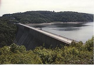
The Rappbode Dam is the largest dam in the Harz region as well as the highest dam in Germany. Together with several other dams and retention basins, it forms the flood protection system for the eastern Harz.

Lichte is a village and a former municipality in the district of Sonneberg in Thuringia, Germany, close to the Thuringian Rennsteig. Formerly in the district Saalfeld-Rudolstadt, it is part of the town Neuhaus am Rennweg since January 2019.
The Oker Dam is a dam in the Harz mountains in Lower Saxony, Germany. It is fed by the River Oker.

The Königshütte Dam is a dam in the German state of Saxony-Anhalt in the Harz mountains. It impounds the River Bode and lies between Königshütte and Susenburg. It is a so-called storage reservoir (Überleitungssperre) forming part of the Rappbode Dam system.

The Rappbode Auxiliary Dam is one of the two auxiliary dams in the Rappbode Dam system. This is the heart of the Rappbode Dam system in the East Harz, which is operated by the Saxony-Anhalt Dam Company and which also includes the Hassel Auxiliary Dam and the Königshütte, Mandelholz and Wendefurth dams.
The Kelbra Dam is a dam on the River Helme in the German state of Saxony-Anhalt. Behind the dam is the lake known as the Kelbra Reservoir or Kelbra Flood Retention Basin.

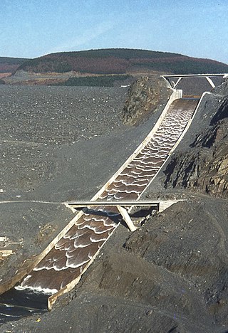
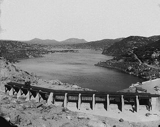
The Leibis-Lichte Dam is a 102.5-metre-tall (336 ft) dam in the German state of Thuringia in the Thuringian Highland. The dam was completed in 2005 to impound the River Lichte, between the Lichte municipality section Geiersthal and Unterweissbach. To that particular storage reservoir belongs the Deesbach Forebay. The name of the dam, "Leibis-Lichte Dam" was derived from the close proximity to the municipalities of Leibis and Lichte, as well as from the Lichte River as being the main inlet.
Morena Dam is a rockfill dam across Cottonwood Creek, a tributary of the Tijuana River, in southern San Diego County, California in the United States. Originally completed in 1912 and raised several times afterward, the dam is one of the oldest components of the city of San Diego's municipal water system, providing between 1,600 to 15,000 acre-feet of water per year. It is one of the few facilities in the San Diego water supply system that relies entirely on local runoff.
