Related Research Articles

The Kingdom of Saudi Arabia is a country situated in Southwest Asia, the largest country of Arabia, by the Arabian Peninsula, bordering the Persian Gulf and the Red Sea, north of Yemen. Its extensive coastlines on the Persian Gulf and Red Sea provide great leverage on shipping through the Persian Gulf and the Suez Canal. The kingdom occupies 80% of the Arabian Peninsula. Most of the country's boundaries with the United Arab Emirates (UAE), Oman, and the Republic of Yemen are undefined, so the exact size of the country remains unknown. The Saudi government estimate is at 2,217,949 square kilometres, while other reputable estimates vary between 2,149,690 and 2,240,000 sq. kilometres. Less than 7% of the total area is suitable for cultivation, and in the early 1960s, population distribution varied greatly among the towns of the eastern and western coastal areas, the densely populated interior oases, and the vast, almost empty deserts.
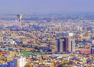
Tabuk, also spelled Tabouk, is the capital city of the Tabuk Region in northwestern Saudi Arabia. It has a population of 667,000. It is close to the Jordanian–Saudi Arabia border, and houses the largest air force base in Saudi Arabia.

Abha is the capital of 'Asir Region in Saudi Arabia, with a population of 1,093,705 as of 2021. It is situated 2,270 metres above sea level in the fertile Asir Mountains of south-western Saudi Arabia, near Asir National Park. Abha's mild climate makes it a popular tourist destination for Saudis.
al-H̨āyir, Al Ha'ir, Ha'ir or Hayer is a small town in Riyadh Province, Saudi Arabia. It is located 208 kilometres (129 mi) by road northwest of Riyadh, in the valley known as Wadi Hanifa. As of the 2004 census it had a population of 13,473 people. The Ha'ir dam serves the area, and it also contains Ha'ir prison.

Hafar al-Batin, also frequently spelled Hafr al-Batin, is a Saudi Arabian city in the Eastern Province. It is located 430 km north of Riyadh, 94.2 km from the Kuwait border, and about 74.3 from the Iraq border. The city lies in the dry valley of the Wadi al-Batin, which is part of the longer valley of the river Wadi al-Rummah, which leads inland toward Medina and formerly emptied into the Persian Gulf.

The Hali Dam is a gravity dam on Wadi Hali about 14 km (8.7 mi) east of Keyad in Makkah Province of southwestern Saudi Arabia. The dam has many purposes to include flood control, irrigation, municipal water supply and groundwater recharge. The dam's reservoir has a total storage of 249,860,000 m3 (202,560 acre⋅ft), making it the second largest in the country after the King Fahad Dam. The dam was constructed between 2003 and 2009. It is owned and operated by the Ministry of Water and Electricity.

The Najran Valley Dam is an arch dam on Wadi Najran about 15 km (9.3 mi) southwest of Najran, in the Najran Province of southwest Saudi Arabia. It has several purpose to include water supply, flood control and groundwater recharge. Its collects run-off and sediment in the wadi and helps release it downstream slowly throughout the year. The dam was completed in 1981, and inaugurated by the Crown Prince of Saudi Arabia Nayef bin Abdulaziz Al Saud in 1982. It is owned by the Ministry of Water and Electricity.

Wadi Hauran is the longest Wadi in Iraq. Located in Al Anbar Governorate west of Iraq, at Latitude33.0333°, Longitude40.2500° Wādī Ḩawrān is roughly midway between Damascus and Baghdad near the town of Rutba, it stretches for 350 kilometres (220 mi) from the Iraq–Saudi border to the Euphrates river near Haditha.
The geology of Saudi Arabia includes Precambrian igneous and metamorphic basement rocks, exposed across much of the country. Thick sedimentary sequences from the Phanerozoic dominate much of the country's surface and host oil.
The Al-Alab dam is a dam in Saudi Arabia opened in 1974 and located in Riyadh region. The main purpose of the dam is flood control.
The Al-Hifah dam is a dam in Saudi Arabia opened in 1981 and located in Asir region.
The Araer dam is a dam in Saudi Arabia opened in 1985 and located in Asir region. The main purpose of the dam is flood control.
The Al-Mahzamah dam is a dam in Saudi Arabia opened in 1980 and located in Asir region. The main purpose of the dam is flood control.
The Arda dam, also known as the Wadi Arda dam, is a dam in Saudi Arabia opened in 1984 and located in Tayif city of Mecca region. The main purpose of the dam is flood control. The estimated cost of the dam is SR140 million.
The Ashran dam is a dam in Saudi Arabia opened in 1985 and located in Asir region. The main purpose of the dam is flood control.
The Beda dam is a dam in Saudi Arabia opened in 1985 and located in Al Baha region.
The Baniqayis dam is a dam in Saudi Arabia opened in 2005 and located in Asir region.
The Assadir dam is a dam in Saudi Arabia opened in 1982 and located in Al Baha region. The main purpose of the dam is irrigation.
The Dhuaian dam is a dam in Saudi Arabia opened in 2000 and located in Al Baha region.
The Radah dam is a dam in Saudi Arabia opened in 1987 and located in Asir region. Water supplied by rainfall is the primary source of this dam. This dam is one of 43 dams in Asir region with a total storage of 358.81 million cubic meters, 17 of which are used for drinking purposes.
References
- 1 2 3 4 5 6 Obaid, R. R. (2015). Seasonal-Water Dams: A Great Potential for Hydropower Generation in Saudi Arabia. Int. J. of Sustainable Water and Environmental Systems, 7(1), 1-7.
- 1 2 3 4 5 6 7 8 9 10 11 12 13 14 15 16 17 18 19 20 21 22 23 24 25 26 27 28 29 30 31 32 Team, GeoNetwork (2007-02-07). "GeoNetwork opensource portal to spatial data and information". www.fao.org. Retrieved 2019-10-27.
- 1 2 3 4 5 6 7 8 Chowdhury, S., & Al-Zahrani, M. (2015). Characterizing water resources and trends of sector wise water consumptions in Saudi Arabia. Journal of King Saud University-Engineering Sciences, 27(1), 68-82.
| Africa |  | |
|---|---|---|
| Asia | ||
| Australasia | ||
| Europe |
| |
| North America | ||
| South America | ||