List of districts in Milton Keynes

Last updated

This is a list of the districts ('grid squares') of Milton Keynes, England. This list only includes settlements and business districts in its built-up-area. [1] For a complete list of areas in the borough, see civil parishes in the City of Milton Keynes.

OpenStreetMap mapping of Milton Keynes, showing most of the districts Milton-Keynes-OpenStreetMap.png
OpenStreetMap mapping of Milton Keynes, showing most of the districts

Click on marker beside "Name" or "Civil Parish" to sort into desired order.
There are no roads
V0 and H0: these co-ordinates indicate that a district lies west/north of V1/H1 and to its own west/north has no grid street.

East ofSouth ofName [2] [3] Civil Parish
V4H3 Two Mile Ash Abbey Hill
V5H3 Wymbush Abbey Hill
V4H2 Kiln Farm Abbey Hill
Outside grid Central Bletchley Bletchley and Fenny Stratford
V6H9 Denbigh North Bletchley and Fenny Stratford
Outside grid Denbigh West Bletchley and Fenny Stratford
V7A5 Denbigh East Bletchley and Fenny Stratford
Outside grid Brickfields Bletchley and Fenny Stratford
Outside grid Water Eaton Bletchley and Fenny Stratford
Outside grid Eaton Manor Bletchley and Fenny Stratford
Outside grid Fenny Stratford Bletchley and Fenny Stratford
V7A5Mount Farm Bletchley and Fenny Stratford
V4H8Granby West Bletchley
Outside grid Denbigh Hall West Bletchley
Outside grid Newton Leys West Bletchley
Outside grid Old Bletchley West Bletchley
Outside grid Far Bletchley West Bletchley
Outside gridWest Bletchley West Bletchley
A5H3 Bradwell Bradwell
V6H3 Heelands Bradwell
A5H4 Rooksley Bradwell
V6H4 Bradwell Common Bradwell
A5H3 Bradwell Abbey Bradwell
V6H1 New Bradwell New Bradwell
V11H6 Broughton and Brooklands Broughton
V11H4 Pineham Broughton
V7H6 Fishermead Campbell Park
V6H6 Oldbrook Campbell Park
A5H6 Winterhill Campbell Park
V8H6 Springfield Campbell Park
V9H6 Woolstone Campbell Park
V10H5 Willen Lake Campbell Park
V9H5 Newlands Campbell Park
V10H4 Willen Campbell Park
V8H5 Campbell Park Central Milton Keynes
V6H5 Central Milton Keynes Central Milton Keynes
V3H1 Fairfields [lower-alpha 1] Fairfields
V8H1 Great Linford Great Linford
V9H1 Giffard Park Great Linford
V10H1 Blakelands Great Linford
V9H3 Bolbeck Park Great Linford
V7H4 Conniburrow Great Linford
V8H4 Downs Barn Great Linford
V9H4 Downhead Park Great Linford
V8H3 Neath Hill Great Linford
V9H3 Pennylands Great Linford
V10H3 Tongwell Great Linford
V9H4 Willen Park Great Linford
V10H8 Kents Hill Kents Hill, Monkston and Brinklow
V11H7 Kingston Kents Hill, Monkston and Brinklow
V10H7 Monkston Kents Hill, Monkston and Brinklow
V11H8 Brinklow Kents Hill, Monkston and Brinklow
V4H7 Elfield Park Loughton and Great Holm
V4H5 Loughton Loughton and Great Holm
V5H4 Loughton Lodge Loughton and Great Holm
V4H4 Great Holm Loughton and Great Holm
V4H6 Knowlhill Loughton and Great Holm
V4H7 National Bowl Loughton and Great Holm
V10H6 Middleton incl.
Milton Keynes Village
Milton Keynes
V11H6 Atterbury Milton Keynes
Outside grid Brook Furlong Milton Keynes
V10H5 Fox Milne Milton Keynes
V11H5 Northfield Milton Keynes
V9H6 Oakgrove Milton Keynes
Outside grid Newport Pagnell [lower-alpha 1] Newport Pagnell
V2H6 Shenley Brook End Shenley Brook End
V3H7 Furzton Shenley Brook End
V3H6 Shenley Lodge Shenley Brook End
V2H7 Emerson Valley Shenley Brook End
V0H6 Kingsmead Shenley Brook End
V0H7 Snelshall Shenley Brook End
V1H7 Tattenhoe Shenley Brook End
V0H7 Tattenhoe Park Shenley Brook End
V1H6 Westcroft Shenley Brook End
V3H4 Crownhill Shenley Church End
V2H4 Grange Farm Shenley Church End
V1H4 Hazeley Shenley Church End
V3H5 Shenley Church End Shenley Church End
V2H5 Medbourne Shenley Church End
V1H5 Oxley Shenley Church End
V1H5 Woodhill Shenley Church End
V7H9 Ashland Simpson
V6H9 West Ashland Simpson
V8H9 Simpson Simpson
V5H2 Bancroft Stantonbury
V5H2 Bancroft Park Stantonbury
V5H1 Blue Bridge Stantonbury
V6H2 Bradville Stantonbury
V7H3 Linford Wood Stantonbury
V7H1 Oakridge Park Stantonbury
V7H2 Stantonbury Stantonbury
V3H0 Stony Stratford Stony Stratford
V4H1 Fullers Slade Stony Stratford
V4H0 Galley Hill Stony Stratford
V10H10 Brown's Wood Walton
V9H10 Caldecotte Walton
V11H10 Old Farm Park Walton
V10H10 Tilbrook Walton
V10H9 Walnut Tree Walton
V11H9 Tower Gate Walton
V9H9 Walton Walton
V9H8 Walton Hall Walton
V9H9 Walton Park Walton
V11H9 Wavendon Gate Walton
Outside grid Eagle Farm North [lower-alpha 1] Wavendon
Outside grid Eagle Farm South [lower-alpha 1] Wavendon
Outside grid Glebe Farm [lower-alpha 1] Wavendon
Outside grid Magna Park [lower-alpha 1] Wavendon
V11H9 Wavendon [lower-alpha 1] Wavendon
V3H3 Whitehouse [lower-alpha 1] Whitehouse
Outside grid Woburn Sands [lower-alpha 1] Woburn Sands
V4H1 Greenleys Wolverton and Greenleys
V5H1 Stonebridge Wolverton and Greenleys
V5H1 Wolverton Wolverton and Greenleys
V5H0 Old Wolverton Wolverton and Greenleys
V5H2 Stacey Bushes Wolverton and Greenleys
V4H2 Hodge Lea Wolverton and Greenleys
V4H0 Wolverton Mill Wolverton and Greenleys
V6H8 Beanhill Woughton
V5H7 Bleak Hall Woughton
V6H7 Coffee Hall Woughton
V7H7 Eaglestone Woughton
V6H7 Leadenhall Woughton
V7H8 Netherfield Woughton
V8H7 Peartree Bridge Woughton
V5H8 Redmoor Woughton
V8H8 Tinkers Bridge Woughton
V8H8 Passmore Old Woughton
V9H7 Woughton on the Green Old Woughton
V9H9 Woughton Park Old Woughton

Notes

  1. 1 2 3 4 5 6 7 8 9 Not in original designated area but subsequent expansion has grown to include it. [1]

Related Research Articles

<span class="mw-page-title-main">Milton Keynes</span> City in Buckinghamshire, England

Milton Keynes is a city in Buckinghamshire, England, about 50 miles (80 km) north-west of London. At the 2021 Census, the population of its urban area was 264,349. The River Great Ouse forms the northern boundary of the urban area; a tributary, the River Ouzel, meanders through its linear parks and balancing lakes. Approximately 25% of the urban area is parkland or woodland and includes two Sites of Special Scientific Interest (SSSIs).

<span class="mw-page-title-main">City of Milton Keynes</span> Unitary authority area in England

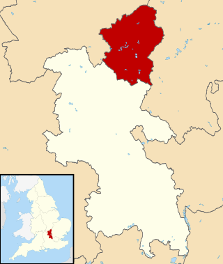
The City of Milton Keynes is a unitary authority area with both borough and city status, in Buckinghamshire. It is the northernmost district of the South East England Region. The borough abuts Bedfordshire, Northamptonshire and the remainder of Buckinghamshire.

Woughton is a civil parish in south central Milton Keynes, Buckinghamshire, England. The parish council uses the term Community Council.

<span class="mw-page-title-main">Newport Pagnell</span> Human settlement in England

Newport Pagnell is a town and civil parish in the City of Milton Keynes, Buckinghamshire, England. The Office for National Statistics records Newport Pagnell as part of the Milton Keynes urban area.

<span class="mw-page-title-main">Bletchley</span> Human settlement in England

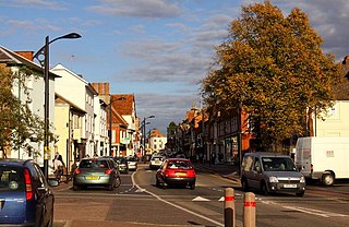
Bletchley is a constituent town of Milton Keynes, Buckinghamshire, England. It is situated in the south-west of the city, and is split between the civil parishes of Bletchley and Fenny Stratford and West Bletchley. In 2011, the two parishes had a combined population of 37,114.

<span class="mw-page-title-main">Broughton, Milton Keynes</span> Civil parish in Milton Keynes, England

Broughton is a historic village, modern district and civil parish in Milton Keynes, Buckinghamshire, England, approximately 3 miles (4.8 km) east of Central Milton Keynes. It is governed by Broughton and Milton Keynes Joint Parish Council, shared with the neighbouring Milton Keynes parish. Broughton district was developed during the 2000s and 2010s largely to the south and east of the historic village.

<span class="mw-page-title-main">Middleton, Milton Keynes</span> Area of Milton Keynes, England

Middleton is an area of Milton Keynes, a city in Buckinghamshire, England, and part of the civil parish of Milton Keynes. Its historic centre is Milton Keynes Village, the village that in 1967 gave its name to the city of which it is now a small part. It is delineated by Childs Way to the north, Tongwell Street to the east, Chaffron Way to the south and Brickhill Street to the west. The River Ouzel runs diagonally through it, from west to north.

<span class="mw-page-title-main">Stantonbury</span> Civil parish in Milton Keynes, England

Stantonbury is a district and civil parish of Milton Keynes, Buckinghamshire, England, situated roughly 2 miles (3.2 km) north of Central Milton Keynes. The toponym Stanton is derived from an Old English term for "stone-built farmstead" and the bury element from the French family Barri who held it in 1235. The original Stantonbury is a deserted medieval village now known as Stanton Low; the Stantonbury name has been reused for the modern district at the heart of the civil parish.

<span class="mw-page-title-main">Walton, Milton Keynes</span> Civil parish in Milton Keynes, England

Walton (historically) was a hamlet that is now a district and civil parish in Milton Keynes, Buckinghamshire, England. For local government purposes, it is part of the Danesborough and Walton electoral ward.

<span class="mw-page-title-main">Woburn Sands</span> Human settlement in England

Woburn Sands is a town that straddles the border between Buckinghamshire and Bedfordshire in England, and is part of the Milton Keynes urban area. The larger part of the town is in Woburn Sands civil parish, which is in the City of Milton Keynes, Smaller parts of the town are in the neighbouring parishes of Aspley Guise and Aspley Heath. The meandering boundary between Buckinghamshire and Bedfordshire means the Lower and Middle Schools that serve all of the town are both in Aspley Guise CP. Bedfordshire Police and Thames Valley Police both deal with law enforcement issues in the town. At the 2011 Census, the population of the civil parish (only) was 2,916, that of the built-up area was 5,959. Woburn Sands, Aspley Guise and Aspley Heath each has its own centre but together the three settlements are a contiguous built-up area.

<span class="mw-page-title-main">Wolverton</span> Human settlement in England

Wolverton is a constituent town of Milton Keynes, England. It is located in the north-west of the city, beside the West Coast Main Line, the Grand Union Canal and the river Great Ouse. It is the administrative seat of Wolverton and Greenleys civil parish.

Bletchley and Fenny Stratford is a civil parish with a town council, in Milton Keynes, Buckinghamshire, England. It was formed in 2001 from the unparished area of Milton Keynes, and according to the 2011 census had a population of 15,313. Together with West Bletchley, it forms the Bletchley built-up area.

<span class="mw-page-title-main">Aspley Heath</span> Human settlement in England

Aspley Heath is a village and civil parish in the Central Bedfordshire district of Bedfordshire, England.

<span class="mw-page-title-main">Milton Keynes North (UK Parliament constituency)</span> Parliamentary constituency in the United Kingdom since 2010

Milton Keynes North is a constituency represented in the House of Commons of the UK Parliament since the 2019 United Kingdom general election by Ben Everitt, a Conservative. At that election, it was one of two constituencies covering the City of Milton Keynes unitary authority area.

<span class="mw-page-title-main">Milton Keynes South (UK Parliament constituency)</span> Parliamentary constituency in the United Kingdom since 2010

Milton Keynes South is a constituency represented in the House of Commons of the UK Parliament since its 2010 creation by Iain Stewart, a Conservative.

<span class="mw-page-title-main">History of Milton Keynes</span> History of the city in England

This history of Milton Keynes details its development from the earliest human settlements, through the plans for a 'new city' for 250,000 people in northern Southeast England, its subsequent urban design and development, to the present day. Milton Keynes, founded in 1967, is the largest settlement and only city in Buckinghamshire. At the 2021 census, the population of its urban area was estimated to have exceeded 256,000.

<span class="mw-page-title-main">City of Leeds</span> Metropolitan District in West Yorkshire, England

Leeds, also known as the City of Leeds, is a metropolitan borough with city status in West Yorkshire, England. The metropolitan borough includes the administrative centre of Leeds and the towns of Farsley, Garforth, Guiseley, Horsforth, Morley, Otley, Pudsey, Rothwell, Wetherby and Yeadon. It has a population of 822,483 (2022), making it technically the second largest city in England by population behind Birmingham, since London is not a single local government entity. Local governance sits with Leeds City Council and the city's 32 Parish Councils.

Milton Keynes City Council is the local authority for the City of Milton Keynes, a unitary authority in Buckinghamshire, England. Until 1 April 1997 it was a non-metropolitan district.

<span class="mw-page-title-main">Old Woughton</span> Civil parish in Milton Keynes, England

Old Woughton is a district and civil parish in south central Milton Keynes, Buckinghamshire, England. The parish was established in April 2012 by the division into two parts of Woughton parish. The original (undivided) civil parish was itself originally called "Woughton on the Green".

References

  1. 1 2 "UNITED KINGDOM: Countries and Major Urban Areas". citypopulation.de. 11 November 2022. Retrieved 16 July 2023.
  2. Farrier, Ken (20 November 2018). "Map: Grids and settlements" (PDF). milton-keynes.gov.uk. Archived (PDF) from the original on 7 May 2024. Retrieved 7 May 2024.
  3. Kingsley, Nichola (17 August 2023). "Map: Milton Keynes Borough" (PDF). milton-keynes.gov.uk. Archived (PDF) from the original on 7 May 2024. Retrieved 7 May 2024.