List of earthquakes in the Philippines

Last updated

Earthquakes in the Philippines
Tectonic map of Philippines.png
Tectonic map of the Philippines
Largest Mw 8.3 1918 Celebes Sea earthquake
DeadliestMw8.0 1976 Moro Gulf earthquake 5,000–8,000 killed

The Philippines lies within the zone of complex interaction between several tectonic plates, involving multiple subduction zones and one large zone of strike-slip, all of which are associated with major earthquakes. Many intraplate earthquakes of smaller magnitude also occur very regularly due to the interaction between the major tectonic plates in the region. The largest historical earthquake in the Philippines was the 1918 Celebes Sea earthquake with Mw 8.3.

Contents

Tectonic setting

Earthquakes in the Philippines and adjacent areas 1900 to 2012 1900 2012 EQ Philippines.png
Earthquakes in the Philippines and adjacent areas 1900 to 2012
Earthquakes in the Philippines and adjacent areas 1500 to 1899 1500 1899 EQs Philippines.png
Earthquakes in the Philippines and adjacent areas 1500 to 1899

Much of the Philippines lie within the area of strongly tectonised blocks of mainly island arc origin, known as the Philippine Mobile Belt. To the east, Philippine Sea Plate is subducting beneath the mobile belt along the line of the Philippine Trench and the East Luzon Trench at the northern end of the belt. The convergence across this boundary is strongly oblique and the strike-slip component is accommodated by movement on the left lateral Philippine Fault System. To the south of the Philippines lies the Molucca Sea Collision Zone, which involves opposite facing subduction zones to either side of the Molucca Sea Plate. To the west of the mobile belt the Sunda Plate is subducting eastwards beneath the belt along the lines of the Manila, Negros and Cotabato trenches. Within the Sunda Plate, the oceanic crust of the Sulu Sea is subducting beneath the Sulu Ridge along the Sulu Trench. [1] The Sunda Plate carries with it parts of the Palawan Microcontinental Block, which has collided with the mobile belt at the Negros and Cotabato trenches. [2]

The continuing movement of the tectonic plates leads to active faulting within the mobile belt, such as on the left lateral Cotabato Fault System that cuts across Mindanao and the right lateral Marikina Valley Fault System on Luzon.

Seismicity

Subduction zones

The subduction zones that surround most of the archipelago are the source of many of the larger earthquakes that strike the Philippines. This includes both faulting along the plate interfaces and within the subducting slabs. For the Philippine Trench, examples of those on the plate interface are the 1988 Mw7.3 and the 2023 M7.6 events. The 1975 Mw7.6 earthquake was caused by intra-slab normal faulting, while the 2012 M7.6 was a result of thrust faulting within the descending slab. [3]

The relatively young Cotabato Trench subduction zone has been associated with several large megathrust earthquakes, including the 1918 Celebes Sea earthquake (M8.3), the 1976 Moro Gulf earthquake (M8.0) and the 2002 Mindanao earthquake (M7.5). [4] [5]

Strike-slip zones

The longest and most seismically active of the strike-slip structures is the 1200 km long Philippine Fault Zone. [6] It carries the left lateral component of the oblique convergence at the Philippine Trench, with a current estimated slip-rate of 35 ± 4 mm per year on Leyte, reducing northwards to about 20 mm per year on Luzon. On Luzon, the fault zone splays out into a number of different faults, including the Digdig Fault. One of the largest historical earthquake on the fault zone was the 1990 Luzon Ms 7.8 event that left nearly 2,000 people dead or missing. The same part of the fault zone is thought to have ruptured in the 1645 Luzon earthquake. [7] Further south the fault ruptured during the 1973 Ragay Gulf earthquake.

In central Mindanao, the Cotabato fault system consists of a mixture of NW-SE trending left lateral and SW-NE trending right lateral strike-slip faults. Four of these ruptured in the 2019 Cotabato and Davao del Sur earthquakes, each generating events with magnitudes of 6.4 or greater. [8]

Seismic hazard

Given the presence of major fault zones throughout the archipelago, any part of the Philippines may be affected by earthquakes, apart from parts of Palawan, where the seismic hazard risk is comparatively low. The greatest shaking hazard comes from shallow crustal faulting close to the Manila, Davao and Cebu metropolitan areas. Active reverse faults have >20 km wide zones of peak ground acceleration (PGA) >0.6g (acceleration due to gravity) for a 10% probability of exceedance (PoE) in a 50 year period, while active strike-slip faults have narrower zones centered around the fault traces at a similar level. All areas close to active subduction zones show increased hazard. [9]

In Metro Manila the estimated hazard has a mean PGA of 0.32 g for a PoE of 10% in 50 years. The main hazard comes from shallow fault sources, such as the Marikina Valley Fault System, but there is an important contribution to the overall hazard from the Manila subduction zone to the west and the potential for strong shaking from earthquakes originating the Philippines Trench to the east. In Metro Cebu, the mean PGA is also 0.32 g for the same PoE and period. The hazard is dominated by shallow crustal fault zones from this area of ongoing compressional tectonics. Using the same parameters Metro Davao has the higher value of 0.45 g. The metropolitan area sits close to shallow faults of left lateral strike-slip and oblique reverse type, and these generate the greatest hazard, although a significant contribution comes from sources in the Halmahera and Philippine subduction zones. [9]

Earthquakes

Spanish period (pre-1900)

The belfry of Manila Cathedral after the series of destructive earthquakes of July 1880. Manila Cathedral belfry after the 1880 earthquake.jpg
The belfry of Manila Cathedral after the series of destructive earthquakes of July 1880.
DateTime‡PlaceMagnitudeIntensityCasualtiesNotesSources
1601 January 1616:00ManilaSeveralEarthquake duration lasted about 7 minutes. Aftershocks experienced the whole year. [10] [11]
1645 November 30 20:00 Luzon 7.5X600 dead,
3,000 injured
Dubbed as the "most terrible earthquake" in the annals of the Philippines. Greatly damaged ten newly-constructed cathedrals in Manila, residential villas and buildings in the city and nearby provinces. Provinces in the north reported several alteration of the ground, disappearances of small villages, changes in the river course, sand eruptions, etc. Small tsunamis were reported in southern Luzon. [11]
1645 December 523:00LuzonVIIIMajor aftershock of the November 30, 1645 Luzon earthquake that further destroyed remaining buildings in Manila and nearby towns. Aftershocks ceased around March 1646. [10] [11]
1665 June 19ManilaVIII19Only the Jesuit Church experienced great damage. [11]
1743 January 1208:00Luzon: Tayabas, LagunaX5 deaths [10] [11]
1787 July 1307:00Panay: Iloilo, Antique, BuenavistaXMany15 deaths in one building [10] [11]
1840 March 22Sorsogon, Masbate Island, Casiguran, Albay6.5IX17200 injured [10] [11]
1852 September 1618:45Luzon: Batnam, Rizal, Pampangan, ManilaIX3 [10] [11]
1863 June 319:20Manila, Balangan, RizalX400 1863 Manila earthquake [10] [11]
1879 July 100:50NW Mindanao, SurigaoX 1879 Surigao earthquake [10] [11]
1880 July 14–24 [12] 04:40LuzonXCaused severe damage to these major cities in Luzon: Manila (Buildings collapsed) [10] [11]
1892 March 1620:58Luzon: Abra, Pangasinan, La UnionX2 [10] [11]
1897 September 2113:15NW Mindanao, Dapitan8.7IX13–100+ (second event) 1897 Mindanao earthquakes A pair of large earthquakes off Mindanao [10] [11]

20th century

The damage caused by a tsunami at Barangay Tibpuan, Lebak, Mindanao after the 7.9 Moro Gulf Earthquake on August 16, 1976. Lebak Tsunami.jpg
The damage caused by a tsunami at Barangay Tibpuan, Lebak, Mindanao after the 7.9 Moro Gulf Earthquake on August 16, 1976.
DateTime‡PlaceMagnitudeIntensityCasualtiesNotesSources
1907 April 1805:00SE Luzon, Camarines7.6IX2 dead [10]
1911 July 12Mindanao: Talacogon, Davao, Butuan7.8XCaused seiches in lakes and the Agusan River. Many homes damaged in Talacogon and Butuan [10]
1918 August 1520:18Cotabato8.3X46 dead 1918 Celebes Sea earthquake [10]
1924 April 1500:20E. Mindanao8.3IX [10]
1925 May 518:07W. Liuzon6.8IX17 dead [10]
1928 December 1919:37Cotabato7.3VII93 dead [10]
1937 August 20Luzon7.5VIII1 dead, 200 injured [10]
1948 January 2501:46Panay, Iloilo City, Antique7.8X72 dead 1948 Lady Caycay earthquake [10]
1954 July 210:45Sorsogon, Bacon, Legaspi6.8IX13 dead, 101 injured [10]
1955 April 102:17Lanao, Ozamiz, Cotabato7.6VIII400 dead 1955 Lanao earthquake [10] [13]
1968 August 204:19Luzon, Manila7.3IX270 dead, 261 injured 1968 Casiguran earthquake [10] [14]
1970 April 713:34Luzon7.3VI15 dead, 200 injured [10]
1973 March 1716:30Ragay Gulf7.5IX15 dead, ~100 injured 1973 Ragay Gulf earthquake [14] [15]
1976 August 1700:11Moro Gulf8.0VIII8,000 dead, 10,000 injured 1976 Moro Gulf earthquake [10] [14]
1983 August 1720:17Luzon6.5VIII16 dead, 47 injured 1983 Luzon earthquake [10] [14]
1985 April 24Luzon: Benguet, Baguio6.1VII6 dead, 11 injured [10]
1988 June 1904:19Mindoro: San Jose, Calapan6.2VII2 dead, 2 injured 1988 Mindoro earthquake [10] [16]
1990 February 815:15Bohol6.8VII6 dead, >200 injured 1990 Bohol Sea earthquake [17]
1990 June 1415:41Panay7.1VIII8 dead, 41 injured 1990 Panay earthquake [14]
1990 July 1616:26Luzon7.8IX2,412 dead, 3,000 injured 1990 Luzon earthquake [10] [14]
1994 November 1403:15Mindoro7.1VII81 dead, 225 injured 1994 Mindoro earthquake [10] [14]
1999 December 1202:03Zambales7.3VIII6 dead, 40 injured 1999 Luzon earthquake [10] [18]

21st century

Santa Cruz Parish Church, Maribojoc, Bohol (Before and After 2013 Bohol Earthquake) Santa Cruz Parish Church, Maribojoc, Bohol (Before and After 2013 Bohol Earthquake).jpg
Santa Cruz Parish Church, Maribojoc, Bohol (Before and After 2013 Bohol Earthquake)
DateTime‡PlaceMagnitudeIntensityCasualtiesNotesSources
2001 January 114:57Mindanao7.5VII [10]
2002 March 605:16Mindanao7.5IX15 dead, 100+ injured 2002 Mindanao earthquake [10]
2003 November 1901:14Samar6.5VII1 dead, 21 injured [10]
2010 July 24Mindanao7.3, 7.6, 7.5III 2010 Mindanao earthquakes triplet earthquake, deep focus events [19]
2012 February 611:49Negros6.7VII113 dead, 112 injured 2012 Negros earthquake [20]
2012 August 3120:47Samar7.6VII1 dead, 1 injured 2012 Samar earthquake [21]
2013 October 1508:12Bohol7.2IX222 dead, 976 injured 2013 Bohol earthquake [22]
2017 February 1022:03Surigao6.5VIII8 dead, 200 injured 2017 Surigao earthquake [23]
2017 July 616:03Leyte6.5VIII4 dead, 100+ injured 2017 Leyte earthquake [24]
2019 April 2217:11Luzon6.1VII18 dead, 256 injured 2019 Luzon earthquake [25]
2019 April 2313:37Eastern Samar6.5VI48 injured 2019 Eastern Samar earthquake [26]
2019 July 920:36Cotabato5.6VI1 dead, 73 injured July 2019 Cotabato earthquake [27]
2019 July 2707:37Batanes6.0VI9 dead, 60 injured 2019 Batanes earthquake [28]
2019 October 1619:37Cotabato6.4VIII7 dead, 215 injured 2019 Cotabato earthquakes [29] [30]
2019 October 2909:04Cotabato6.6VIII24 dead, 563 injured
2019 October 3109:11Cotabato6.5VIII
2019 December 1514:11Davao del Sur6.8VII13 dead, 210 injured 2019 Davao del Sur earthquake [31]
2020 August 1808:03Masbate6.6VIII2 dead, 170 injured 2020 Masbate earthquake [32]
2021 August 1201:46Davao Oriental7.1VII1 dead 2021 Davao Oriental earthquake [33]
2022 July 2708:43Luzon7.0VIII11 dead, 615 injured 2022 Luzon earthquake [34]
2023 November 1716:14Mindanao6.7VIII11 dead, 730 injured November 2023 Mindanao earthquake [35]
2023 December 222:37Mindanao7.6VII3 dead, 79 injured December 2023 Mindanao earthquake [36]

Deadliest earthquakes

Ten deadliest recorded earthquakes in the Philippines since the 1600s
Magnitude LocationDateDeathsMissingInjuredDamageSource
18.0 Moro Gulf August 16, 19764,7912,2889,928
27.8 Luzon Island July 16, 19901,6211,000>3,000 10 billion
3Unknown Manila June 3, 18631,000 [11]
47.5 Luzon Island November 30, 1645>600>3,000Unknown
58.1 Mati, Davao Oriental April 14, 1924~500 [37] [38]
67.4 Lanao del Sur April 1, 1955>400Unknown US$5 million [39]
77.6 Casiguran, Aurora August 2, 1968271261
87.2 Bohol and Cebu October 15, 20132228796 4 billion (est.) [40]
96.7 Negros Oriental February 6, 2012113112 383 million
107.1 Mindoro November 15, 199478430 5.15 million [41]

See also

Related Research Articles

<span class="mw-page-title-main">Manila Trench</span> Oceanic trench in the South China Sea, west of Luzon and Mindoro in the Philippines

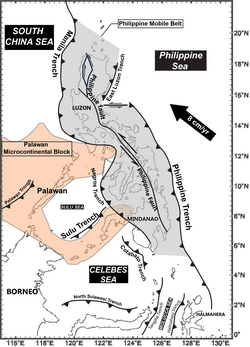
The Manila Trench is an oceanic trench in the Pacific Ocean, located west of the islands of Luzon and Mindoro in the Philippines. The trench reaches a depth of about 5,400 metres (17,700 ft), in contrast with the average depth of the South China Sea of about 1,500 metres (4,900 ft). It is created by subduction, in which the Sunda Plate is subducting under the Philippine Mobile Belt, producing this almost N-S trending trench. The convergent boundary is terminated to the north by the Taiwan collision zone, and to the south by the Mindoro terrane. It is an area pervaded by negative gravity anomalies.

<span class="mw-page-title-main">Philippine Trench</span> Submarine trench to the east of the Philippines in the Pacific Ocean

The Philippine Trench is a submarine trench to the east of the Philippines. The trench is located in the Philippine sea of the western North Pacific Ocean and continues NNW-SSE. It has a length of approximately 1,320 kilometres and a width of about 30 km (19 mi) from the center of the Philippine island of Luzon trending southeast to the northern Maluku island of Halmahera in Indonesia. At its deepest point, the trench reaches 10,540 meters.

<span class="mw-page-title-main">1990 Luzon earthquake</span> Earthquake in the Philippines

The 1990 Luzon earthquake occurred on July 16 at 4:26 p.m. (PDT) or 3:26 p.m. (PST) on the densely populated island of Luzon in the Philippines. The shock had a surface wave magnitude of 7.8 and produced a 125 km-long ground rupture that stretched from Dingalan, Aurora to Kayapa, Nueva Vizcaya. The event was a result of strike-slip movements along the Philippine Fault and the Digdig Fault within the Philippine Fault System. The earthquake's epicenter was near the town of Rizal, Nueva Ecija, northeast of Cabanatuan. An estimated 1,621 people were killed, most of the fatalities located in Central Luzon and the Cordillera region.

<span class="mw-page-title-main">1976 Moro Gulf earthquake</span> Earthquake in the Philippines

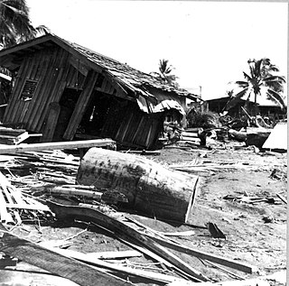
The 1976 Moro Gulf earthquake and tsunami occurred on August 17, 1976, at 00:11 local time near the islands of Mindanao and Sulu, in the Philippines. It measured 8.0 on the moment magnitude scale occurring at a depth of 20 km (12 mi). The earthquake was accompanied by a destructive tsunami that resulted in a majority of the estimated 5,000 to 8,000 fatalities. It was the deadliest and strongest earthquake in the Philippines in 58 years since the 1918 Celebes Sea earthquake.

<span class="mw-page-title-main">Philippine Mobile Belt</span> Tectonic boundary

In the geology of the Philippines, the Philippine Mobile Belt is a complex portion of the tectonic boundary between the Eurasian Plate and the Philippine Sea Plate, comprising most of the country of the Philippines. It includes two subduction zones, the Manila Trench to the west and the Philippine Trench to the east, as well as the Philippine Fault System. Within the Belt, a number of crustal blocks or microplates which have been shorn off the adjoining major plates are undergoing massive deformation.

The Philippine Fault System is a major inter-related system of geological faults throughout the whole of the Philippine Archipelago, primarily caused by tectonic forces compressing the Philippines into what geophysicists call the Philippine Mobile Belt. Some notable Philippine faults include the Guinayangan, Masbate and Leyte faults.

<span class="mw-page-title-main">2013 Bohol earthquake</span> Magnitude 7.2 earthquake in Bohol

The 2013 Bohol earthquake occurred on October 15 at 8:12:31 PST in Bohol, an island province located in Central Visayas, Philippines. The magnitude of the earthquake was recorded at Mw 7.2, with epicenter 6 kilometres (3.7 mi) S 24° W of Sagbayan, and its depth of focus was 12 kilometres (7.5 mi). It affected the whole Central Visayas region, particularly Bohol and Cebu. The earthquake was felt in the whole Visayas area and as far as Masbate island in the north and Cotabato provinces in southern Mindanao.

The 2017 Surigao earthquake occurred on February 10, 2017, at 10:03 PM (PST), with a surface wave magnitude of 6.7 off the coast of Surigao del Norte in the Philippines. According to the PHIVOLCS Earthquake Intensity Scale the earthquake was an Intensity VII (Destructive) earthquake at maximum. In the past Surigao province has been hit by a magnitude 7.2 tremor in both 1879 and 1893.

The 2019 Eastern Samar Earthquake struck the islands of Visayas in the Philippines on April 23, 2019 at 1:37:51 PM(PHT).It had a moment magnitude of 6.5(Mww6.4 by USGS) and a local magnitude of 6.2 with a max intensity of VI based on the PHIVOLCS Earthquake Intensity Scale(PEIS). The epicenter was in San Julian, Eastern Samar and the hypocenter was at a depth of 64 km(~39.76 mi). As of April 30, 2019 there were 172 aftershocks ranging from magnitudes of 1.6 to 4.6. The earthquake injured 48 people and damaged about 245 homes.

<span class="mw-page-title-main">Subduction tectonics of the Philippines</span>

The subduction tectonics of the Philippines is the control of geology over the Philippine archipelago. The Philippine region is seismically active and has been progressively constructed by plates converging towards each other in multiple directions. The region is also known as the Philippine Mobile Belt due to its complex tectonic setting.

The 2019 Cotabato earthquakes were an earthquake swarm which struck the province of Cotabato on the island of Mindanao in the Philippines in October 2019. Three of these earthquakes were above 6.0 on the moment magnitude scale with a Mercalli intensity of VIII. More than 40 people have been reported dead or missing and nearly 800 were injured as a result of these events.

At 14:11 PST on December 15, 2019, the province of Davao del Sur on the island of Mindanao in the Philippines was struck by an earthquake measuring 6.8 Mww. It had a maximum perceived intensity of VII on the Modified Mercalli Intensity Scale. At least 13 people were killed and another 210 injured.

On 9 July 2019, at 8:36 PM (PST), an earthquake measuring Mw 5.6 jolted the province of North Cotabato, Davao del Sur, and other nearby provinces. The National Disaster Risk Reduction and Management Council reported one dead and three injured in Makilala after the earthquake, and a total of 164 families affected in Cotabato Province. Near the epicenter of the earthquake, the severity of strong ground motion was assigned VI (Strong) on the Modified Mercalli intensity scale. A total of 106 schools, 119 houses, and 14 other infrastructures were damaged by the earthquake.

On February 7, 2021, at 12:22 PM PST, an earthquake measuring Mww  6.0 struck Davao del Sur and Cotabato. The event registered a Modified Mercalli Intensity Scale (MMI) of VIII (Severe) with VII on the PHIVOLCS Earthquake Intensity Scale (PEIS).

On August 12, 2021, at 01:46:12 PST, a strong Mw  7.1 earthquake struck the island of Mindanao at a depth of 55.1 kilometers (34.2 mi). It had a maximum perceived Intensity V on the PHIVOLCS Earthquake Intensity Scale. No damage or injuries were reported but a young man was killed by the earthquake.

The 1879 Surigao earthquake occurred on June 30 at 18:38 02:55 local time on the northeastern tip of Mindanao. The earthquake with a moment magnitude (Mw ) of 7.4 struck with an epicenter just south of Lake Mainit. Extensive damage occurred but there were no reports of casualties.

The 1955 Lanao earthquake struck Lanao del Sur on April 1 at 02:17 local time. The earthquake measuring 7.4 on the moment magnitude scale and assigned a maximum intensity of VIII (Severe) on the Modified Mercalli intensity scale was one of the largest to hit Mindanao. It caused immense damage around Lake Lanao and the southern reaches of the Visayan islands. It killed at least 465 individuals and injured a further 898.

<span class="mw-page-title-main">2022 Luzon earthquake</span> Earthquake in the Philippines

On July 27, 2022, at 8:43:24 a.m. (PHT), an earthquake struck the island of Luzon in the Philippines. The earthquake had a magnitude of 7.0 Mw , with an epicenter in Abra province. Eleven people were reported dead and 615 were injured. At least 35,798 homes, schools and other buildings were damaged or destroyed, resulting in ₱1.88 billion (US$34 million) worth of damage.

<span class="mw-page-title-main">November 2023 Mindanao earthquake</span> Magnitude 6.7 earthquake in the Philippines

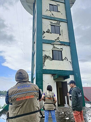
At 16:14 PST on November 17, 2023, the province of Sarangani on the island of Mindanao in the Philippines was struck by an earthquake measuring 6.7 Mww. It had a maximum perceived intensity of VIII (Severe) on the Modified Mercalli Intensity Scale. At least eleven people were killed and another 730 were treated for injuries.

<span class="mw-page-title-main">December 2023 Mindanao earthquake</span> Magnitude 7.6 earthquake in the Philippines

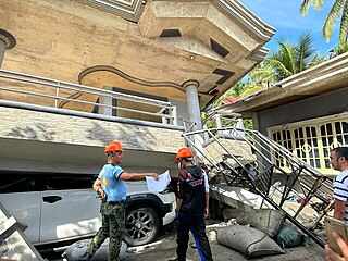
On December 2, 2023, at 22:37 PST, a magnitude 7.4-7.6 earthquake occurred off the island of Mindanao in the Philippines. The shallow subduction earthquake killed at least three people and left 79 injured.

References

  1. Yumul, G.P.; Dim, C.B.; Maglambayan, V.B.; Marquez, E.J. (2008). "Tectonic setting of a composite terrane: A review of the Philippine island arc system". Geosciences Journal. 12 (1): 7. Bibcode:2008GescJ..12....7Y. doi:10.1007/s12303-008-0002-0. S2CID   140627389.{{cite journal}}: Text "Earthquakes in the Phillippines andalanta" ignored (help)
  2. Yumul, G.P.; Dimalanta, C.B.; Tamayo, R.A. (2005). "Indenter-tectonics in the Philippines: Example from the Palawan Microcontinental Block - Philippine Mobile Belt Collision". Resource Geology. 55 (3): 189–198. Bibcode:2005ReGeo..55..189Y. doi: 10.1111/j.1751-3928.2005.tb00240.x .
  3. Ye, L.; Lay, T.; Kanamori, H. (2012). "Intraplate and interplate faulting interactions during the August 31, 2012, Philippine Trench earthquake (Mw 7.6) sequence". Geophysical Research Letters. 39 (24). doi:10.1029/2012GL054164.
  4. Stewart, G.S.; Cohn, S.N. (1979). "The 1976 August 16, Mindanao , Philippine earthquake (Ms = 7.8) - evidence for a subduction zone south of Mindanao". Geophysical Journal of the Royal Astronomical Society. 57 (1): 51–65. Bibcode:1979GeoJ...57...51S. CiteSeerX   10.1.1.926.8672 . doi:10.1111/j.1365-246X.1979.tb03771.x.
  5. ANSS. "Mindanao 2002". Comprehensive Catalog. U.S. Geological Survey.
  6. Besana, G.M.; Ando, M. (2005). "The central Philippine Fault Zone: Location of great earthquakes, slow events, and creep activity". Earth Planets Space. 57 (10): 987–994. Bibcode:2005EP&S...57..987B. doi: 10.1186/BF03351877 .
  7. Beavan, J.; Silcock, D.; Hamburger, M.; Ramos, E.; Thibault, C.; Feir, R. (2001). "Geodetic constraints on postseismic deformation following the 1990 Ms7.8 Luzon earthquake and implications for Luzon tectonics and Philippine Sea plate motion". Geochemistry, Geophysics, Geosystems. 2 (9). doi:10.1029/2000GC000100.
  8. Li, B.; Li, Y.; Jiang, W.; Su, Z.; Shen, W. (2020). "Conjugate ruptures and seismotectonic implications of the 2019 Mindanao earthquake sequence inferred from Sentinel-1 InSAR data". International Journal of Applied Earth Observation and Geoinformation. 90. doi: 10.1016/j.jag.2020.102127 .
  9. 1 2 Peñarubia, H.C.; Johnson, K.L.; Allen, T.I. (2020). "Probabilistic seismic hazard analysis model for the Philippines". Earthquake Spectra. 36 (1). doi:10.1177/87552930199005 (inactive May 11, 2024).{{cite journal}}: CS1 maint: DOI inactive as of May 2024 (link)
  10. 1 2 3 4 5 6 7 8 9 10 11 12 13 14 15 16 17 18 19 20 21 22 23 24 25 26 27 28 29 30 31 32 33 "Significant earthquakes: Philippines". National Geophysical Data Center / World Data Service (NGDC/WDS): NCEI/WDS Global Significant Earthquake Database. NOAA National Centers for Environmental Information. Retrieved December 18, 2023.
  11. 1 2 3 4 5 6 7 8 9 10 11 12 13 14 "The Project Gutenberg eBook of Catalogue of Violent and Destructive Earthquakes in the Philippines, by Rev. Miguel Saderra Masó, S.J." www.gutenberg.org. Retrieved July 29, 2022.
  12. Maso, Saderra (1902). "Seismic and Volcanic Centers of the Philippine Archipelago". pg.16. Bureau of Printing, Manila.
  13. "A Primer on the 12 April 2017 Magnitude 6.0 Lanao del Sur Earthquake (relative to the 1955 Lanao quake)". PHIVOLCS. April 12, 2017. Retrieved May 22, 2022.
  14. 1 2 3 4 5 6 7 "Destructive Earthquakes in the Philippines". phivolcs.dost.gov.ph. PHIVOLCS . Retrieved October 17, 2021.
  15. "Today in Earthquake History". earthquake.usgs.gov. Retrieved August 31, 2021.
  16. "Further Information on the 1988 Mindoro earthquake". earthquake.usgs.gov. Archived from the original on September 8, 2021. Retrieved September 8, 2021.
  17. "February 08, 1990 Earthquake in Bohol Province. PHIVOLCS". Archived from the original on August 13, 2021.
  18. "Philippines - Earthquake OCHA Situation Report No. 2 - Philippines". ReliefWeb. December 13, 1999. Retrieved October 1, 2021.
  19. USGS (July 26, 2010). "M7.3, 7.6, 7.4 Moro Gulf, Mindanao, Philippines Earthquakes of 23 July 2010" (PDF). Retrieved April 30, 2012.
  20. "Remiscence of the 2012 Ms6.9 Negros Oriental Quake". www.phivolcs.dost.gov.ph. Philippine Institute of Volcanology and Seismology. Archived from the original on February 14, 2021. Retrieved December 24, 2022.
  21. Santos, Matikas. "7.6 quake jolts PH; 1 dead, child hurt". Philippine Daily Inquirer. Retrieved December 28, 2016.
  22. "SitRep No. 35 re Effects of Magnitude 7.2 Sagbayan, Bohol Earthquake" (PDF). National Disaster Risk Reduction and Management Council. November 3, 2013. Archived from the original (PDF) on December 14, 2013. Retrieved November 7, 2013.
  23. "Aftershocks rattle survivors after Philippine quake kills 8". Fox News. February 12, 2017. Retrieved February 12, 2017.
  24. Dacanay, Barbara Mae (July 8, 2017). "Four dead, 100 injured in Leyte's 6.5 magnitude quake". GulfNews. Retrieved July 9, 2017.
  25. NDRRMC. "NDRRMC Update: SitRep No. 15 re Magnitude 6.1 Earthquake in Castillejos, Zambales" (PDF). Retrieved May 1, 2019.
  26. NDRRMC. "NDRRMC Update: SitRep No. 09 re Magnitude 6.5 Earthquake in San Julian, Eastern Samar" (PDF). Archived from the original (PDF) on June 20, 2020. Retrieved April 30, 2019.
  27. "Earthquake Information re Magnitude 5.6 Earthquake in Makilala (North Cotabato)_". ndrrmc.gov.ph. National Disaster Risk Reduction and Management Council. July 13, 2019. Retrieved August 26, 2021.
  28. Arayta, Maria Cristina (July 27, 2019). "8 dead, 60 hurt in Batanes quake; public warned vs. aftershocks". PTV News. Philippine News Agency. Retrieved July 27, 2019.
  29. National Disaster Risk Reduction and Management Council (November 20, 2019). "NDRRMC Update: SitRep No. 30 regarding Magnitude 6.6 and 6.5 Earthquakes in Tulunan, North Cotabato" (PDF). Retrieved November 20, 2019.
  30. National Disaster Risk Reduction and Management Council (October 18, 2019). "Situational Report No. 03 regarding Magnitude 6.3 in Tulanan, North Cotabato" (PDF). Retrieved October 18, 2019.
  31. National Disaster Risk Reduction and Management Council (December 22, 2019). "NDRRMC Update: SitRep No. 12 regarding Magnitude 6.9 Earthquake in Matanao, Davao del Sur (Region XI)" (PDF). Retrieved December 22, 2019.
  32. "Masbate quake death toll rises to 2, hundreds injured as aftershocks rock Cataingan town". CNN Philippines. August 19, 2020. Archived from the original on January 25, 2021.
  33. Alexander Lopez (August 13, 2021). "Fallen coconuts from strong quake kill man in Tandag City". Philippine News Agency . Retrieved September 3, 2021.
  34. Situational Report No. 15 for Magnitude 7 Earthquake in Tayum, Abra (2022) (PDF) (Report). National Disaster Risk Reduction and Management Council. August 10, 2022. Archived (PDF) from the original on August 10, 2022. Retrieved August 10, 2022.
  35. "Mindanao quake death toll rises to 11". ABS-CBN. November 21, 2023. Archived from the original on November 22, 2023. Retrieved November 21, 2023.
  36. "Situation Report No. 18 for the Magnitude 7.4 and 6.8 Earthquake In Hinatuan, Surigao del Sur" (PDF). National Disaster Risk Reduction and Management Council. December 17, 2023. Retrieved December 19, 2023.
  37. durianburgdavao (June 19, 2015). "UPDATES: PHIVOLCS WARNS OF DAVAO 'KILLER QUAKE'". THE DURIAN POST. Retrieved August 2, 2022.
  38. "M 8.1 - 6 km E of Tibanbang, Philippines". earthquake.usgs.gov. Retrieved August 2, 2022.
  39. NCEI. "Global Significant Earthquake Database, 2150 B.C. to present". NOAA National Centers for Environmental Information.
  40. "Massive extremely dangerous earthquake in Bohol, Philippines – At least 222 people killed, 8 missing, over 790 injured, around 4 billion PHP damage, 7 billion PHP reconstruction costs". Earthquake-Report.com. November 14, 2013. Archived from the original on November 26, 2013. Retrieved December 16, 2019.
  41. "1994 Mindoro Tsunami". Philippine Institute of Volcanology and Seismology. Archived from the original on March 8, 2004. Retrieved February 7, 2012.