2019 Cotabato earthquakes

Last updated

2019 Cotabato earthquakes
Philippines relief location map (Mindanao).svg
Green pog.svg
Bacolod
Green pog.svg
Cebu City
Red pog.svg
Davao
Red pog.svg
Kidapawan
Orange pog.svg
General Santos
Green pog.svg
Zamboanga
Yellow pog.svg
Cagayan De Oro
Yellow pog.svg
Butuan City
Green pog.svg
Lamitan
Yellow pog.svg
Bislig
Green pog.svg
Mambajao
Green pog.svg
Tagbilaran
Green pog.svg
Puerto Princesa
2019 Cotabato earthquakes (Mindanao)
Philippines relief location map (square).svg
Green pog.svg
Bacolod
Green pog.svg
Cebu City
Red pog.svg
Davao
Red pog.svg
Kidapawan
Orange pog.svg
General Santos
Green pog.svg
Puerto Princesa
2019 Cotabato earthquakes (Philippines)
UTC  time 
 A: 2019-10-16 11:37:06
 B: 2019-10-29 01:04:44
 C: 2019-10-31 01:11:19
ISC  event 
 A: 616636559
 B: 616739626
 C: 616742152
USGS-ANSS  
 A: ComCat
 B: ComCat
 C: ComCat
Local date 
 A: October 16, 2019 (2019-10-16) [1]
 B: October 29, 2019 (2019-10-29) [2]
 C: October 31, 2019 (2019-10-31) [3]
Local time 
 A: 7:37 pm (PST) [1]
 B: 9:04 am (PST) [2]
 C: 9:11 am (PST) [3]
Magnitude 
 A: 6.4 Mww
 B: 6.6 Mww
 C: 6.5 Mww
Depth 
 A: 16.1 km (10 mi)
 B: 15.0 km (9 mi)
 C: 10.0 km (6 mi)
Epicenter 6°45′N125°00′E / 6.75°N 125.00°E / 6.75; 125.00
22 km southeast of Tulunan, Cotabato
Type Strike-slip
Areas affected Soccsksargen, Davao Region, Bangsamoro, Caraga
Max. intensity VIII (Severe)

PEIS – VII (Destructive) [4]
TsunamiNone
LandslidesYes [5]
ForeshocksA. 5.0 Makilala - V (October 11, 2019), 4.7 Tulunan - IV (October 15, 2019)
Casualties
  • October 16: 7 dead, 215 injured
  • October 29 and 31: 24 dead, 11 missing, 563 injured

The 2019 Cotabato earthquakes were an earthquake swarm which struck the province of Cotabato on the island of Mindanao in the Philippines in October 2019. [6] Three of these earthquakes were above 6.0 on the moment magnitude scale with a Mercalli intensity of VIII. More than 40 people have been reported dead or missing and nearly 800 were injured as a result of these events.

Contents

Tectonic setting

Mindanao lies across the complex convergent boundary between the Sunda Plate and the Philippine Sea Plate. [7] Part of the oblique convergence between these plates is taken up by subduction along the Cotabato Trench. The strike-slip component of the convergence is accommodated partly by the Philippine Fault System and partly by the Cotabato Fault System, a network of mainly NW-SE trending sinistral (left-lateral) strike-slip faults that form the boundary between the Cotabato Arc and the Central Mindanao Volcanic Belt. [8] In the area of the October 2019 earthquakes series, the individual faults include the NW-SE trending South Columbio Fault, North Columbio Fault, M'Lang Fault, Makilala–Malungon Fault and Tangbulan Fault, and the SW-NE trending Makilala Fault and Balabag Fault. [9]

Earthquakes M≥5.0

Events at or above Mw 5.0 associated with the 2019 Cotabato earthquakes
DateTime (UTC)Magnitude Mw Intensity DepthLocationRef.
October 1611:37:066.410.0 km (6.2 mi)7 km (4.3 mi) ENE of Columbio [10]
October 1612:09:315.59.9 km (6.2 mi)10 km (6.2 mi) ENE of Columbio [11]
October 1822:52:185.028.1 km (17.5 mi)7 km (4.3 mi) W of Magsaysay [12]
October 1911:44:285.210.0 km (6.2 mi)4 km (2.5 mi) S of Magsaysay [13]
October 2008:55:325.210.0 km (6.2 mi)7 km (4.3 mi) N of Lambayong [14]
October 2011:50:355.010.0 km (6.2 mi)8 km (5.0 mi) WNW of Kiblawan [15]
October 2111:59:435.110.0 km (6.2 mi)6 km (3.7 mi) NW of Kiblawan [16]
October 2901:04:446.69.0 km (5.5 mi)14 km (8.7 mi) E of Bual [17]
October 2902:22:355.110.0 km (6.2 mi)1 km (0.62 mi) SE of Saguing [18]
October 2902:42:396.110.0 km (6.2 mi)10 km (6.2 mi) E of Bagontapay [19]
October 2908:33:125.410.0 km (6.2 mi)11 km (6.8 mi) E of Bagontapay [20]
October 2908:46:035.210.0 km (6.2 mi)2 km (1.2 mi) SW of Dolo [21]
October 2921:22:075.0V12.9 km (8.0 mi)7 km (4.3 mi) W of Magsaysay [22]
October 3101:11:196.56.0 km (3.7 mi)0 km (0 mi) NW of Bulatukan [23]

Major earthquakes

Map of the M>=5 earthquakes from the October 2019 sequence, highlighting the three largest. The location of the main active faults are also shown 2019 Cotabato EQs+faults.png
Map of the M≥5 earthquakes from the October 2019 sequence, highlighting the three largest. The location of the main active faults are also shown

October 16

The Philippine Institute of Volcanology and Seismology (PHIVOLCS) reported that an earthquake of 6.3 magnitude was recorded at 19:37 PST (UTC+8) with a depth of 10.0 km kilometers (recorded as 6.4 Mw at a depth of 12.8 km by the USGS). The epicenter was 7 kilometers ENE of Columbio, [10] 22 kilometers southeast of Tulunan, Cotabato where the earthquake was felt at Intensity VII. [1] VII was also reached at M'lang and Kidapawan. Intensity VI was reached at Tacurong, Santo Niño in South Cotabato, and Digos in Davao del Sur. The earthquake was a result of sinistral movement on a NW-SE trending strike-slip fault. [24] [25] [26]

Magnitude 6.3 [27]
PEIS REPORTED INTENSITIES
IntensityLocation
PEIS – VII (Destructive) Tulunan, M'lang, Makilala and Kidapawan, Cotabato
PEIS – VI (Very Strong) Digos, Davao del Sur; Santo Nino, South Cotabato; Tacurong, Sultan Kudarat
PEIS – V (Strong) President Roxas and Pikit, Cotabato; Koronadal, Lake Sebu, Polomolok, Tampakan and Tupi, South Cotabato; General Santos; Alabel and Malungon, Sarangani; Davao City; Kalamansig, Lebak and Palimbang, Sultan Kudarat
PEIS – IV (Moderately strong) Kiamba, Sarangani; Esperanza and Rosario, Agusan del Sur; Kalilangan, Quezon, Kadingilan and Damulog, Bukidnon; Mawab, Compostela Valley; Cotabato City; Matanog, Barira, and Sultan Kudarat, Maguindanao
PEIS – III (Weak) Santa Josefa, Agusan del Sur; Iligan; Dipolog; Cagayan de Oro; Gingoog, Misamis Oriental;
PEIS – II (Slightly felt) Butuan; Zamboanga City
PEIS – I (Scarcely perceptible) Hinatuan, Surigao del Sur

Philippine government seismologist Renato Solidum described the quake as "moderately powerful". The National Tsunami Center issues a statement saying no present tsunami threat from the earthquake. [28] [29] [30]

Three malls in Davao City reported damage following the earthquake. [31] In General Santos, the Gaisano Mall was mostly gutted following a fire triggered by the earthquake. [32] 143 buildings were damaged and one was destroyed. The damaged buildings included 40 houses, 70 schools, 7 health facilities, 10 commercial buildings, and 2 places of worship. [33]

October 29

On October 29, a 6.6-magnitude earthquake struck Mindanao at a depth of 14.0 km, according to the USGS, and 7 km according to PHIVOLCS. The maximum perceived shaking was VII on both the PEIS and MMS scales. This intensity was reached in Tulunan, Makilala, Kidapawan City, Digos, and Malungon. This earthquake was caused by movement on a different, but related, strike-slip fault to the October 16 event. [34] [35]

Magnitude 6.6 [36]

PEIS REPORTED INTENSITIES
IntensityLocation
PEIS – VII (Destructive) Tulunan and Makilala, Cotabato; Kidapawan City; Digos, Bansalan,

Magsaysay, Davao del Sur and Malungon, Sarangani

PEIS – VI (Very Strong) Koronadal City and Davao City
PEIS – V (Strong) Cotabato City; Tampakan, Surallah, Banga and Tupi, South Cotabato;

General Santos; Magpet, Cotabato; Tacurong City, Kalamansig, Bagumbayan, Sultan Kudarat; Alabel, Sarangani; Kalilangan and Damulog, Bukidnon; Tagum City, Davao del Norte

PEIS – IV (Moderately strong) Cagayan De Oro City; Talakag, Manolo Fortich and Libona, Bukidnon;

Glan, Maitum, Maasim and Kiamba, Sarangani; Butuan City; Iligan City; Tubod and Bacolod, Lanao del Norte

PEIS – III (Weak) Molave, Zamboanga del Sur; Dipolog City, Sergio Osmeņa Sr. and Polanco,

Zamboanga del Norte; Zamboanga City; Gingoog City, Misamis Oriental and Bislig City

PEIS – II (Slightly felt) Kabasalan, Zamboanga Sibugay, Mambajao, Camiguin and Isabela City, Basilan
PEIS – I (Scarcely perceptible) Palo, Leyte; Dipolog City and Bislig City

A major fire broke out in General Santos. There were power outages in many parts of Cotabato and locally in South Cotabato, Sultan Kudarat, and Sarangani. [37] At least ten deaths were reported, with a minimum of another four hundred injured. [38] The fatalities were reported in Arakan, Carmen, Tulunan, Makilala, Digos, and Magsaysay. School classes were suspended in parts of North Cotabato, South Cotabato, and Sultan Kudarat. [39]

October 31

On October 31, a 6.5 magnitude earthquake struck Mindanao at a depth of 10 km according to the USGS, with the epicenter located 1 km south of Kisante. A maximum perceived shaking of VII (PEIS) was reported from Tulunan, Makilala, Kidapawan City, Santa Cruz, Matanao, Magsaysay, Bansalan and Digos. Some buildings in Davao and Soccksargen were seriously damaged and some collapsed. The death toll of these two quakes (October 29 and 31) was raised to 24, with 563 people injured, and 11 still missing. [40] More than 300 aftershocks were recorded after the earthquake.

Magnitude 6.5 [41]

PEIS REPORTED INTENSITIES
IntensityLocation
PEIS – VII (Destructive) Tulunan and Makilala, Cotabato; Kidapawan; Matanao, Bansalan, Magsaysay and Santa Cruz, Davao del Sur; Digos
PEIS – VI (Very Strong) Davao City; Hagonoy, Davao del Sur
PEIS – V (Strong) Polomolok, Tampakan, Tupi, Surallah and Sto Nino, South Cotabato; Isulan, Sultan Kudarat; Malungon, Sarangani; Koronadal; General Santos
PEIS – IV (Moderately strong) Lake Sebu, South Cotabato; Lebak, Kalamansig, Pigcawayan and Esperanza, Sultan Kudarat; Kalilangan, Damulog, Kadingilan and Talakag, Bukidnon; Alabel, Malampatan and Kiamba, Sarangani; Tacurong
PEIS – III (Weak) Banga, South Cotabato; Lambayon, Sultan Kudarat; Baungon, Manolo Fortich, Don Carlos, Maramag, Quezon, Libona, Valencia and Malaybalay, Bukidnon; Tubod and Kauswagan, Lanao Del Norte; Naawan, Misamis Oriental; El Salvador; Gingoog; Cagayan de Oro; Butuan; Bislig
PEIS – II (Slightly felt) Sindangan and Polanco, Zamboanga del Norte; Las Nieves, Agusan del Sur; Dapitan; Dipolog
PEIS – I (Scarcely perceptible) Zamboanga City

A hotel in Kidapawan City collapsed following the earthquake; according to the National Disaster Risk Reduction and Management Council (NDRRMC), no one was inside when the earthquake struck. [42] The Davao City government suspended the classes on all levels. [43] Affected residents in Makilala, Cotabato were seen begging on the highway for basic needs such as rice and tents. [44] [45] According to the NDRRMC, about 30,000 families or 150,000 individuals were affected by the earthquake. [44]

December 15

The Cotabato sequence was followed by an earthquake, with a magnitude of Mw 6.8 (ANSS) or Ms 6.9 (PHIVOLCS), on December 15 at 14:11 PST with an epicenter in the neighboring province of Davao del Sur. It had a hypocentral depth of between 22.4 km (ANSS) and 3.0 km (PHIVOLCS) and a maximum felt intensity of VII MMI or VII PEIS. [46] The greatest damage was reported from the towns of Matanao, Magsaysay, Hagonoy and Padada. The earthquake caused 13 deaths and a further 210 people were injured. [47]

Analysis using InSAR data

The sequence of four earthquakes has examined using Interferometric synthetic aperture radar (InSAR). One study used information only from Sentinel-1, [26] while the other also included information from ALOS-2. [25] InSAR interferograms can be used to detect and quantify ground deformation associated with an earthquake, allowing the location and orientation of fault ruptures, epicenters and slip distributions to be estimated. For the second and third earthquakes in the sequence no information was recorded by either of the satellites between the events, so these events had to be analysed together. Sufficient data were available to allow the other two earthquakes to be analysed separately. [26] [25]

The two studies give similar results, confirming that the first and last major earthquakes in the sequence were caused by rupture along NW-SE trending left-lateral strike-slip faults, while the second and third resulted from rupture along SW-NE trending right-lateral strike-slip faults nearly orthogonal to the other two. One of the studies matched the four interpreted ruptures to known faults. The first event is interpreted to have ruptured the M'lang Fault, the second the Makilala Fault, the third the Balabag Fault and the last the Makilala-Malungon Fault. The observed sequence of earthquakes rupturing orthogonal strike-slip fault sets has been compared to the 2019 Ridgecrest earthquake sequence. [26]

Landslides

The earthquake sequence triggered a large number of landslides and rockslides. Municipalities affected by landslides include Kidapawan City, Antipas, Arakan, Makilala, M'Lang and Tulunan in Cotabato province; Magsaysay, Bansalan, Malalag, Matanao and Kiblawan in Davao Del Sur. [9] Three fatalities were caused by landslides triggered by the October 29 shock with a further six people reported missing. Two fatalities were caused by landslides triggered by the October 31 shock, with a further five people reported missing. [40]

Effects on infrastructure

Damage to infrastructure in the eight most badly affected areas from the earthquakes on October 29 and October 31 [40]
ProvinceHousesSchoolsHealth facilitiesOther public structuresPlaces of worshipCommercial buildingsRoads & Bridges
DestroyedDamagedDestroyedDamagedDestroyedDamagedDestroyedDamagedDestroyedDamagedDestroyedDamagedDestroyedDamaged
North Cotabato21,1207,9152050521762541514924015
Davao del Sur2,1857,505226027129320011209
Sultan Kudarat142401320102000000
Davao Occidental120131404000400
Maguindanao0200290002040000
South Cotabato11702230203000502
Davao del Norte00011302015010101
Sarangani0013980001000100

Reactions

International

The US Ambassador to the Philippines, Sung Kim, and the EU delegation to the Philippines both offered their condolences to the Filipino people. Chinese Foreign Minister Wang Yi also sent his message of sympathy to Philippine Foreign Secretary Teodoro Locsin Jr. The Chinese government has donated ¥3 million yuan (roughly equivalent to ₱22 million pesos) to support the disaster relief efforts in Mindanao. [48] Meanwhile, the Spanish Consulate in the Philippines pledged to donate up to 35,000 euros to the International Federation of Red Cross and Red Crescent Societies and 70,000 euros to assist people in water, hygiene and sanitation. [49]

Domestic

The Provincial Government of South Cotabato, Sarangani and the City of General Santos was one of the first to initiate to help the citizens with blankets, trapal, food and water near the epicenter of the earthquake swarm, most especially in the Municipalities of Makilala, Tulunan, M'lang and City of Kidapawan. [50] Local citizens in Soccsksargen acted in both giving donations in the government processes and privately giving donations across the highway in Makilala, Tulunan and Kidapawan. The Davao City Government also helped the affected areas. The Island Garden City of Samal Government also went to Cotabato Province to give relief goods and drinking water. The Bangsamoro Government also went to the affected areas to give relief goods. The municipal government of Datu Saudi Ampatuan also went to the area to share donations to help the affected people. Among other institutions that immediately helped where banks, malls, universities and schools in Soccsksargen and Davao Region to assist their fellow Mindanaoans in crisis. [50]

See also

Related Research Articles

<span class="mw-page-title-main">Earthquake swarm</span> Series of localized seismic events within a short time period

In seismology, an earthquake swarm is a sequence of seismic events occurring in a local area within a relatively short period. The time span used to define a swarm varies, but may be days, months, or years. Such an energy release is different from the situation when a major earthquake is followed by a series of aftershocks: in earthquake swarms, no single earthquake in the sequence is obviously the main shock. In particular, a cluster of aftershocks occurring after a mainshock is not a swarm.

<span class="mw-page-title-main">Kidapawan</span> Capital of Cotabato, Philippines

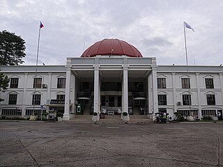
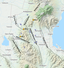
Kidapawan, officially the City of Kidapawan, is a 3rd class component city and capital of the province of Cotabato, Philippines. According to the 2020 Census, it has a population of 160,791 people.

<span class="mw-page-title-main">Makilala</span> Municipality in Cotabato, Philippines

Makilala, officially the Municipality of Makilala, is a 1st class municipality in the province of Cotabato, Philippines. According to the 2020 census, it has a population of 87,927 people.

<span class="mw-page-title-main">Tulunan</span> Municipality in Cotabato, Philippines

Tulunan, officially the Municipality of Tulunan, is a 2nd class municipality in the province of Cotabato, Philippines. According to the 2020 census, it has a population of 60,978 people.

<span class="mw-page-title-main">1976 Moro Gulf earthquake</span> Earthquake in the Philippines

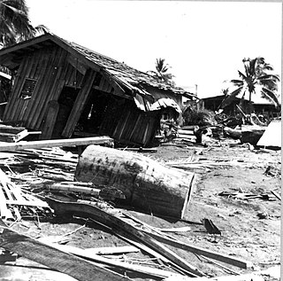
The 1976 Moro Gulf earthquake and tsunami occurred on August 17, 1976, at 00:11 local time near the islands of Mindanao and Sulu, in the Philippines. It measured 8.0 on the moment magnitude scale occurring at a depth of 20 km (12 mi). The earthquake was accompanied by a destructive tsunami that resulted in a majority of the estimated 5,000 to 8,000 fatalities. It was the deadliest and strongest earthquake in the Philippines in 58 years since the 1918 Celebes Sea earthquake.

<span class="mw-page-title-main">2002 Mindanao earthquake</span> 2002 M-7.5 earthquake in Mindanao, Philippines

The 2002 Mindanao earthquake struck the Philippines at 05:16 Philippine Standard Time on March 6. The world's sixth most powerful earthquake of the year, it registered a magnitude of 7.5 and was a megathrust earthquake. It originated near the Cotabato Trench, a zone of deformation situated between the Philippine Sea Plate and the Sunda Plate, and occurred very near to the Philippines' strongest earthquake for the 20th century, the 1918 Celebes Sea earthquake.

An earthquake off the coast of Samar occurred on August 31, 2012, at 20:47 local time in the Philippines. The populated islands of Visayas were struck by an earthquake of magnitude Mw 7.6. The earthquake occurred at a depth of 45 km. A tsunami warning was announced within the Pacific area and was lifted after two hours. The Philippine archipelago is located in the Pacific Ring of Fire, where earthquakes and volcanic activity are common.

<span class="mw-page-title-main">2013 Bohol earthquake</span> Magnitude 7.2 earthquake in Bohol

The 2013 Bohol earthquake occurred on October 15 at 8:12:31 PST in Bohol, an island province located in Central Visayas, Philippines. The magnitude of the earthquake was recorded at Mw 7.2, with epicenter 6 kilometres (3.7 mi) S 24° W of Sagbayan, and its depth of focus was 12 kilometres (7.5 mi). It affected the whole Central Visayas region, particularly Bohol and Cebu. The earthquake was felt in the whole Visayas area and as far as Masbate island in the north and Cotabato provinces in southern Mindanao.

The 2017 Surigao earthquake occurred on February 10, 2017, at 10:03 PM (PST), with a surface wave magnitude of 6.7 off the coast of Surigao del Norte in the Philippines. According to the PHIVOLCS Earthquake Intensity Scale the earthquake was an Intensity VII (Destructive) earthquake at maximum. In the past Surigao province has been hit by a magnitude 7.2 tremor in both 1879 and 1893.

<span class="mw-page-title-main">Makilala–Allah Valley Road</span>

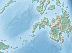
The Makilala–Allah Valley Road, is a 72-kilometer (45 mi) two-to-four lane highway in the Philippines that connects the provinces of North Cotabato, Maguindanao, and Sultan Kudarat. It is classified as a national primary highway for Mindanao. It also connects to the Maharlika Highway in Tacurong City. It lessens the travel time from North Cotabato to Sultan Kudarat.

On April 22, 2019, a 6.1 magnitude earthquake struck the island of Luzon in the Philippines, leaving at least 18 dead, three missing and injuring at least 256 others. Despite the fact that the epicenter was in Zambales, most of the damage to infrastructure occurred in the neighboring province of Pampanga, which suffered damage to 29 buildings and structures.

<span class="mw-page-title-main">2019 Batanes earthquake</span> Natural disaster

The 2019 Batanes earthquake was a magnitude 6.0 earthquake which struck Batanes, Philippines on July 27, 2019. It was preceded by a 5.4 magnitude foreshock. Nine people were killed by the combined effects of the earthquakes.

<span class="mw-page-title-main">2019 Davao del Sur earthquake</span> Earthquake in the Philippines

At 14:11 PST on December 15, 2019, the province of Davao del Sur on the island of Mindanao in the Philippines was struck by an earthquake measuring 6.8 Mw. It had a maximum perceived intensity of VII on the Modified Mercalli Intensity Scale. At least 13 people were killed and another 210 injured.

On 9 July 2019, at 8:36 PM (PST), an earthquake measuring Mw 5.6 jolted the province of North Cotabato, Davao del Sur, and other nearby provinces. The National Disaster Risk Reduction and Management Council reported one dead and three injured in Makilala after the earthquake, and a total of 164 families affected in Cotabato Province. Near the epicenter of the earthquake, the severity of strong ground motion was assigned VI (Strong) on the Modified Mercalli intensity scale. A total of 106 schools, 119 houses, and 14 other infrastructures were damaged by the earthquake.

On February 7, 2021, at 12:22 PM PST, an earthquake measuring Mw  6.0 struck Davao del Sur and Cotabato. The event registered a Modified Mercalli Intensity Scale (MMI) of VIII (Severe) with VII on the PHIVOLCS Earthquake Intensity Scale (PEIS).

On August 12, 2021, at 01:46:12 PST, a strong Mw  7.1 earthquake struck the island of Mindanao at a depth of 56.7 kilometers (35.2 mi). It perceived Intensity V on the PHIVOLCS Earthquake Intensity Scale. No damage or injuries were reported but a young man was killed by the earthquake.

The 1955 Lanao earthquake struck Lanao del Sur on April 1 at 02:17 local time. The earthquake measuring 7.4 on the moment magnitude scale and assigned a maximum intensity of VIII (Severe) on the Modified Mercalli intensity scale was one of the largest to hit Mindanao. It caused immense damage around Lake Lanao and the southern reaches of the Visayan islands. It killed at least 465 individuals and injured a further 898.

<span class="mw-page-title-main">November 2023 Mindanao earthquake</span> Magnitude 6.7 earthquake in the Philippines

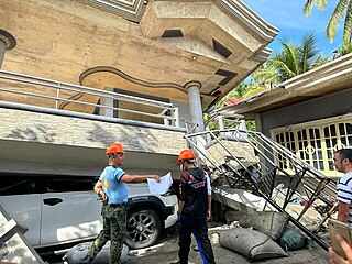
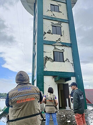
At 16:14 PST on November 17, 2023, the province of Sarangani on the island of Mindanao in the Philippines was struck by an earthquake measuring 6.7 Mww. It had a maximum perceived intensity of VIII (Severe) on the Modified Mercalli Intensity Scale. At least eleven people were killed and another 730 were treated for injuries.

<span class="mw-page-title-main">December 2023 Mindanao earthquake</span> Magnitude 7.6 earthquake in the Philippines

On December 2, 2023, at 22:37 PST, a magnitude 7.4-7.6 earthquake occurred off the island of Mindanao in the Philippines. The shallow subduction earthquake killed at least three people and left 79 injured.

References

  1. 1 2 3 "Earthquake Information – 16 Oct 2019 – 07:37:04 PM". PHIVOLCS. Archived from the original on December 2, 2019. Retrieved October 16, 2019.
  2. 1 2 "Earthquake Information – 29 Oct 2019 – 09:04:43 AM". PHIVOLCS. Archived from the original on October 31, 2019. Retrieved October 29, 2019.
  3. 1 2 "Earthquake Information – 31 Oct 2019 – 09:11:18 AM". PHIVOLCS. Archived from the original on October 31, 2019. Retrieved October 31, 2019.
  4. Philippine Institute of Volcanology and Seismology (2018). "PHIVOLCS Earthquake Intensity Scale (PEIS)" . Retrieved November 13, 2019.
  5. "6.6-magnitude na lindol nag-iwan ng pinsala sa Davao Region | Bandila" (in Tagalog). ABS-CBN News via YouTube.
  6. "Quake 'swarm' hits Mindanao". The Manila Times. October 31, 2019. Retrieved November 5, 2019.
  7. "Philippine Sea Plate". Tectonics of Asia. Retrieved November 3, 2019.
  8. United States Geological Survey (2010). "Porphyry Copper Assessment of East and Southeast Asia— Philippines, Taiwan (Republic of China), Republic of Korea (South Korea), and Japan" (PDF). Global Mineral Resource Assessment. p. 3032.
  9. 1 2 Philippine Institute of Volcanology and Seismology (November 8, 2019). "Update on the October 2019 Cotabato Fault System Earthquake Series" . Retrieved November 10, 2019.
  10. 1 2 "M 6.4 – 7km ENE of Columbio, Philippines". United States Geological Survey. October 16, 2019. Retrieved October 16, 2019.
  11. "M 5.3 – 10km NE of Columbio, Philippines". United States Geological Survey. October 16, 2019. Retrieved October 16, 2019.
  12. "M 5.0 – 7km W of Magsaysay, Philippines". United States Geological Survey. October 18, 2019. Retrieved October 18, 2019.
  13. "M 5.2 – 4km S of Magsaysay, Philippines". United States Geological Survey. October 19, 2019. Retrieved October 19, 2019.
  14. "M 5.2 – 7km N of Lambayong, Philippines". United States Geological Survey. October 20, 2019. Retrieved October 20, 2019.
  15. "M 5.0 - 8km WNW of Kiblawan, Philippines". United States Geological Survey. Retrieved November 11, 2019.
  16. "M 5.1 – 6km NW of Kiblawan, Philippines". United States Geological Survey. October 21, 2019. Retrieved October 21, 2019.
  17. "M 6.6 – 14km E of Bual, Philippines". United States Geological Survey. October 29, 2019. Retrieved October 29, 2019.
  18. "M 5.0 – 1km SE of Saguing, Philippines". United States Geological Survey. October 29, 2019. Retrieved October 29, 2019.
  19. "M 5.8 – 10km E of Bagontapay, Philippines". United States Geological Survey. October 29, 2019. Retrieved October 29, 2019.
  20. "M 5.3 – 11km E of Bagontapay, Philippines". United States Geological Survey. October 29, 2019. Retrieved October 29, 2019.
  21. "M 5.2 – 2km SW of Dolo, Philippines". United States Geological Survey. October 29, 2019. Retrieved October 29, 2019.
  22. "M 5.0 - 7km W of Magsaysay, Philippines". United States Geological Survey. Retrieved November 11, 2019.
  23. "M 6.5 – 0km NW of Bulatukane, Philippines". United States Geological Survey. October 31, 2019. Retrieved October 31, 2019.
  24. Department of Science and Technology, Philippine Institute of Volcanology and Seismology (October 17, 2019). "Primer on the 16 October 2019 Magnitude 6.3 Tulanan, Cotabato Earthquake" (PDF). Retrieved October 18, 2019.
  25. 1 2 3 Zhao, L.; Qu, C.; Shan, X.; Zhao, D.; Gong, W.; Li, Y. (2021). "Coseismic deformation and multi-fault slip model of the 2019 Mindanao earthquake sequence derived from Sentinel-1 and ALOS-2 data". Tectonophysics. 799. doi:10.1016/j.tecto.2020.228707.
  26. 1 2 3 4 Li, B.; Li, Y.; Jiang, W.; Su, Z.; Shen, W. (2020). "Conjugate ruptures and seismotectonic implications of the 2019 Mindanao earthquake sequence inferred from Sentinel-1 InSAR data". International Journal of Applied Earth Observation and Geoinformation. 90. doi: 10.1016/j.jag.2020.102127 .
  27. 1.  "Earthquake Information – 16 Oct 2019 – 07:37:04 PM". PHIVOLCS. Archived from the original on December 2, 2019. Retrieved October 16, 2019.
  28. "U.S. Tsunami Warning Centers". U.S. Tsunami Warning Centers. Retrieved October 16, 2019.
  29. "Strong earthquake strikes southern Philippines". The Washington Post. Associated Press. Archived from the original on October 16, 2019.
  30. Dalton, Jane (October 16, 2019). "Philippines earthquake: Child killed and dozens injured as major 6.4-magnitude quake hits Mindanao island" . The Independent. Archived from the original on October 16, 2019. Retrieved October 16, 2019.
  31. "At least 5 dead, dozens injured in Mindanao earthquake". Rappler. Retrieved October 17, 2019.
  32. Fernandez, Edwin O. "Firemen still battling Gaisano fire in General Santos". Philippine Daily Inquirer. Retrieved October 17, 2019.
  33. National Disaster Risk Reduction and Management Council (October 18, 2019). "Situational Report No. 03 regarding Magnitude 6.3 in Tulanan, North Cotabato" (PDF). Retrieved October 18, 2019.
  34. "Magnitude 6.6 earthquake jolts parts of Mindanao". ABS-CBN News. Retrieved October 29, 2019.
  35. Department of Science and Technology, Philippine Institute of Volcanology and Seismology (October 30, 2019). "Primer on the 29 October 2019 Magnitude 6.6 Tulunan, Cotabato Earthquake" . Retrieved October 30, 2019.
  36. 1. "Earthquake Information – 29 Oct 2019 – 09:04:43 AM". PHIVOLCS. Archived from the original on October 31, 2019. Retrieved October 29, 2019.
  37. National Disaster Risk Reduction and Management Council (October 29, 2019). "NDRRMC Update: Situational Report No. 18 regarding Magnitude 6.3 and 6.6 Earthquakes in Tulanan, North Cotabato as of 12:00 NN" (PDF). Retrieved October 30, 2019.
  38. National Disaster Risk Reduction and Management Council (November 2, 2019). "NDRRMC Update: SitRep No. 08 regarding Magnitude 6.6 and 6.5 Earthquakes in Tulunan, Nurth Cotabato" (PDF). Retrieved November 2, 2019.
  39. "Quake aftermath: 9 dead, 7 missing, at least 200 injured". MindaNews. Retrieved October 30, 2019.
  40. 1 2 3 National Disaster Risk Reduction and Management Council (November 20, 2019). "NDRRMC Update: SitRep No. 30 regarding Magnitude 6.6 and 6.5 Earthquakes in Tulunan, North Cotabato" (PDF). Retrieved November 20, 2019.
  41. 1. "Earthquake Information – 31 Oct 2019 – 09:11:18 AM". PHIVOLCS. Archived from the original on October 31, 2019. Retrieved October 31, 2019.
  42. "Kidapawan hotel nearly collapses after magnitude 6.5 quake, several injured". ABS-CBN News. October 31, 2019. Retrieved November 4, 2019.
  43. Apatan, Arianne; Palacio, Paul; Araneta, Vina; Tocmo, Hermel; Merez, Arianne (October 31, 2019). "Third quake in a month jolts Mindanao: 1 killed, buildings damaged". ABS-CBN News. Retrieved November 4, 2019.
  44. 1 2 "Mga naapektuhan ng lindol sa Cotabato nagmakaawa ng ayuda sa kalsada | TV Patrol" [Earthquake victims in Cotabato beg for help on the road TV Patrol] (in Tagalog). ABS-CBN News . Retrieved November 4, 2019 via YouTube.
  45. "DSWD, iginiit na sapat ang tulong nila sa quake victims | TV Patrol" [DSWD, insisting that they have enough assistance to quake victims | TV Patrol] (in Tagalog). ABS-CBN News via YouTube.
  46. ANSS. "Davao del Sur 2019: M 6.8 - 6km S of Magsaysay, Philippines". Comprehensive Catalog. U.S. Geological Survey. Retrieved December 15, 2019.
  47. Disaster Response Operations Monitoring and Information Center (December 29, 2019). "DSWD DROMIC Report #11 on the Ms 6.9 Earthquake Incident in Matanao, Davao del Sur" (PDF). Retrieved December 31, 2019.
  48. Tomacruz, Sofia (November 3, 2019). "Foreign leaders send sympathies to Philippines after Cotabato earthquakes". Rappler. Retrieved November 3, 2019.
  49. "Consulate General of Spain in Manila". Facebook. November 6, 2019. Retrieved November 10, 2019.
  50. 1 2 Bombo Koronadal News Team (November 1, 2019). "Food assistance, stress debriefers kag iban pa nga bulig ginpalab-ot sang South Cotabato para sa North Cotabato quake victims". Bombo Radyo Korondal (in Cebuano). Retrieved November 10, 2019.