List of local nature reserves in West Sussex

Last updated

Pagham Harbour Pagham Harbour creek - geograph.org.uk - 230063.jpg
Pagham Harbour

Local nature reserves (LNRs) are designated by local authorities under the National Parks and Access to the Countryside Act 1949. The local authority must have a legal control over the site, by owning or leasing it or having an agreement with the owner. LNRs are sites which have a special local interest either biologically or geologically, and local authorities have a duty to care for them. They can apply local bye-laws to manage and protect LNRs. [1] [2]

Contents

As of March 2019, there are twenty-seven LNRs in West Sussex. [3] Nine are Sites of Special Scientific Interest, six are Nature Conservation Review sites, four are Ramsar sites, two are Special Areas of Conservation, four are Special Protection Areas, one includes a scheduled monument and two are managed by the Sussex Wildlife Trust.

West Sussex is in south-east England and it has a population of approximately 780,000. [4] The county town is Chichester. In the north of the county are the heavy clays and sands of the Weald. The chalk of the South Downs runs across the centre from east to west and in the south a coastal plain runs down to the English Channel. [5]

Map all coordinates using: OpenStreetMap  
Download coordinates as: KML

Key

Sites

SitePhotographArea [lower-alpha 1] Location [lower-alpha 2] BoroughOther classificationsMap [lower-alpha 3] Details [lower-alpha 4] AccessDescription
Ardingly Reservoir Ardingly Reservoir.JPG 74.5 hectares
(184 acres)
Haywards Heath
51°02′56″N0°06′18″W / 51.049°N 0.105°W / 51.049; -0.105 (Ardingly Reservoir)
TQ 329 294
Mid Sussex Map Details YesThe reservoir has open water, hay meadow, deciduous woodland, hazel coppice, reedbeds and wetland. There are sandstone outcrops which support uncommon ferns, mosses, liverworts and lichens. Nesting birds include great crested grebes and kingfishers. [7]
Ashenground and Bolnore Woods Ashenground Wood (8).jpg 14.4 hectares
(36 acres)
Haywards Heath
50°59′24″N0°06′58″W / 50.990°N 0.116°W / 50.990; -0.116 (Ashenground and Bolnore Woods)
TQ 323 229
Mid Sussex Map Details YesThese woods have oak, beech and field maple, together with old coppice hornbeam, ash and hazel. Fauna include bats, woodpeckers and owls. [8]
Bedelands Farm Nature Reserve Footpath, Big Wood - geograph.org.uk - 843927.jpg 36.2 hectares
(89 acres)
Burgess Hill
50°58′19″N0°07′23″W / 50.972°N 0.123°W / 50.972; -0.123 (Bedelands Farm Nature Reserve)
TQ 319 208
Mid Sussex Map Details YesThe farm has woodland, wildflower meadows, grazed meadows, wetland and ancient hedgerows. The woodland has ancient hornbeams and wild service trees, while wildflowers include the yellow rattle. [9]
Blunts Wood and Paiges Meadow Blunts Wood and Paiges Meadow (1).jpg 28.9 hectares
(71 acres)
Haywards Heath
51°00′14″N0°07′26″W / 51.004°N 0.124°W / 51.004; -0.124 (Blunts Wood and Paiges Meadow)
TQ 317 244
Mid Sussex Map Details YesThis site has diverse habitats with a pond, wetland, hedgerows, grassland, birch woodland, hazel coppice, mixed coppice and bluebell woodland. [10]
Brandy Hole Copse Bridge at Brandy Hole Copse - geograph.org.uk - 48322.jpg 6.5 hectares
(16 acres)
Chichester
50°51′07″N0°47′28″W / 50.852°N 0.791°W / 50.852; -0.791 (Brandy Hole Copse)
SU 852 065
Chichester SM [11] Map Details YesThis site has broadleaved and coniferous woodland, open water, marshland, heath, tall fern and herbs. Fauna includes pipistrelle bats. [12]
The Brooks Local Nature Reserve The Brooks Local Nature Reserve (8).jpg 19.1 hectares
(47 acres)
Bognor Regis
50°48′18″N0°40′34″W / 50.805°N 0.676°W / 50.805; -0.676 (The Brooks (Bersted Brooks))
SU 934 014
Arun Map Details YesThe Brooks has extensive grassland, reedbeds, ponds and newly planted woodland. One area has been turned into a dog-free wildlife sanctuary for ground-nesting birds. The site is flooded every winter, which makes it a good habitat for wetland flora and fauna. [13]
Burton and Chingford Ponds Burton Mill Pond - geograph.org.uk - 1260268.jpg 63.0 hectares
(156 acres)
Petworth
50°56′56″N0°36′43″W / 50.949°N 0.612°W / 50.949; -0.612 (Burton and Chingford Ponds)
SU 976 175
Chichester SSSI [14] SWT [15] Map Details YesThis site has ponds, carr woodland, bog, wet heath and marshy grassland. There is a diverse range of invertebrates including three nationally rare species, the snail Omphiscola glabra and the craneflies Erioptera meijerei and Tipula marginata . The site is also important for its breeding water birds, such as water rails and great crested grebes. [16]
Eames Farm Eames Farm (3).jpg 132.5 hectares
(327 acres)
Southbourne
50°49′59″N0°55′34″W / 50.833°N 0.926°W / 50.833; -0.926 (Eames Farm)
SU 757 043
Chichester NCR [17] Ramsar [18] SPA [19] SSSI [20] Map Details NoThis area of grazing marsh, wetland and reedbed is managed as an organic farm. It has many rare plants and insects and a diverse variety of migrating waders and wildfowl. [21]
Eastern Road Nature Reserve Eastern Road Nature Reserve (5).jpg 3.5 hectares
(8.6 acres)
Haywards Heath
51°00′36″N0°04′23″W / 51.010°N 0.073°W / 51.010; -0.073 (Eastern Road Nature Reserve)
TQ 353 252
Mid Sussex Map Details YesThe reserve has rough grassland, wetland, woodland and scrub. There are aquatic insects such as dragonflies and other invertebrates include frogs and newts. [22]
Fairmile Bottom The Skirts of Rewell Wood - geograph.org.uk - 336661.jpg 61.3 hectares
(151 acres)
Arundel
50°52′34″N0°35′46″W / 50.876°N 0.596°W / 50.876; -0.596 (Fairmile Bottom)
SU 989 094
Arun SSSI [23] Map Details YesThis site has wildflower meadows on chalk and woodland with groves of yew trees. There is an outstanding variety of beetles and many moths and butterflies. [24]
Grattons Park Grattons Park (5).jpg 7.7 hectares
(19 acres)
Crawley
51°07′37″N0°09′32″W / 51.127°N 0.159°W / 51.127; -0.159 (Grattons Park)
TQ 289 380
Crawley Map Details Yes Gatwick Stream runs through this park and other habitats are broadleaved woodland and grassland. Flora include lesser celandine and wild daffodils, while there are birds such as treecreepers, great spotted woodpecker and long-tailed tits. [25]
Harting Down Whitcombe Bottom - geograph.org.uk - 946390.jpg 206.6 hectares
(511 acres)
Harting
50°57′22″N0°51′50″W / 50.956°N 0.864°W / 50.956; -0.864 (Harting Down)
SU 799 180
Chichester NCR [26] SSSI [27] Map Details YesThis sloping site on the South Downs has grassland with scattered woodland and scrub. There are grizzled skipper butterflies, blue carpenter bees and cheese snails. [28]
Iping Common (Stedham with Iping) Start of footpath to Trotton Common - geograph.org.uk - 778718.jpg 118.2 hectares
(292 acres)
Midhurst
50°59′24″N0°47′31″W / 50.990°N 0.792°W / 50.990; -0.792 (Iping Common)
SU 849 219
Chichester NCR [29] SSSI [30] SWT [31] Map Details YesThis is described by Natural England as one of the richest areas of heath in the county. Most of it is dry but there are also areas of wet heath, two ponds, woodland, scrub and grassland. It has a rich invertebrate fauna and breeding heathland birds include nightjars and stonechats. [32]
Lancing Ring Lancing Ring - geograph.org.uk - 1012346.jpg 29.4 hectares
(73 acres)
Lancing
50°50′35″N0°19′23″W / 50.843°N 0.323°W / 50.843; -0.323 (Lancing Ring)
TQ 182 062
Adur Map Details YesThis chalk grassland site has adders and lizards. There is also woodland with flowers including early purple orchids and dewponds which have many newts. [33]
Lynchmere Commons Lynchmere Common - geograph.org.uk - 21563.jpg 122.0 hectares
(301 acres)
Linchmere
51°04′19″N0°46′05″W / 51.072°N 0.768°W / 51.072; -0.768 (Lynchmere Commons)
SU 864 310
Chichester Map Details YesThis heathland site is composed of Stanley, Lynchmere and Marley Commons. They have diverse insect species and unusual plants such as bilberries. [34]
Mill Hill Shoreham Bank Butterfly Site - geograph.org.uk - 354544.jpg 13.5 hectares
(33 acres)
Shoreham-by-Sea
50°51′11″N0°16′52″W / 50.853°N 0.281°W / 50.853; -0.281 (Mill Hill)
TQ 211 073
Adur Map Details YesThis site has chalk grassland, scrub and secondary woodland. It is one of the best areas in Sussex for butterflies, with 29 species recorded, including the Adonis blue. More than 160 species of flowering plant have been recorded, such as horseshoe vetch. [35]
Nutborne Marshes Cobnor Rithe - geograph.org.uk - 1262985.jpg 386.9 hectares
(956 acres)
Thorney Island
50°49′19″N0°54′00″W / 50.822°N 0.900°W / 50.822; -0.900 (Nutborne Marshes)
SU 776 031
Chichester NCR [17] Ramsar [36] SAC [37] SPA [38] SSSI [39] Map Details NoThis is an area of intertidal and subtidal saltmarsh and mudflats. There are many invertebrates on the mudflats such as ragworms and the banks have unusual plants including sea wormwood. Migrating birds include curlews, grey plovers and dunlins. [40]
Pagham Harbour Saltmarsh, Pagham Harbour - geograph.org.uk - 501421.jpg 599.1 hectares
(1,480 acres)
Bognor Regis
50°45′58″N0°45′58″W / 50.766°N 0.766°W / 50.766; -0.766 (Pagham Harbour)
SZ 871 970
Arun NCR [41] Ramsar [42] SPA [43] SSSI [41] Map Details PPThis is a large area of salt marsh, mud flats, shingle, open water, reed swamp and wet grassland. It is of national importance for breeding birds and wintering wildfowl and waders. It also has nationally important communities of plants and invertebrates, including the nationally endangered sea anemone Nematostella vectensis . [44]
Pilsey Island Pilsey Island.JPG 17.8 hectares
(44 acres)
Thorney Island
50°48′04″N0°54′32″W / 50.801°N 0.909°W / 50.801; -0.909 (Pilsey Island)
SU 770 007
Chichester NCR [17] Ramsar [36] SAC [37] SPA [38] SSSI [39] Map Details NoThe island has sand dunes, mudflats, salt marsh and bare and vegetated shingle. There are many plants, spiders and insects. [45]
Scrase Valley Scrase Valley (2).jpg 8.0 hectares
(20 acres)
Haywards Heath
51°00′14″N0°05′10″W / 51.004°N 0.086°W / 51.004; -0.086 (Scrase Valley)
TQ 344 245
Mid Sussex Map Details YesThis site has grassland, woodland and marsh. There are a number of unusual plants, such as purple toothwort, marsh cinquefoil, meadow thistle and marsh speedwell. The Friends of The Scrase Valley have planted three black poplar trees, which is a nationally rare species. [46]
Shoreham Beach Tidal waters by Shoreham Beach, West Sussex - geograph.org.uk - 1646758.jpg 26.2 hectares
(65 acres)
Shoreham-by-Sea
50°49′34″N0°16′16″W / 50.826°N 0.271°W / 50.826; -0.271 (Shoreham Beach)
TQ 219 044
Adur Map Details YesThe beach has vegetated shingle, which is an internationally rare habitat, with flora including yellow horned poppy, sea kale and curled dock. [47]
Target Hill Park Target Hill Park (6).jpg 9.0 hectares
(22 acres)
Crawley
51°05′49″N0°13′05″W / 51.097°N 0.218°W / 51.097; -0.218 (Target Hill Park)
TQ 249 346
Crawley Map Details YesThe diverse habitats in this park include ponds, wetlands, woodlands, meadows and scrub. There are reptiles such as slow-worms, adders and common lizards, while butterflies include skippers, meadow brown, small heaths and ringlets. [48]
Tilgate Forest NCR 20 - Tilgate Forest.JPG 6.9 hectares
(17 acres)
Crawley
51°06′07″N0°09′47″W / 51.102°N 0.163°W / 51.102; -0.163 (Tilgate Forest)
TQ 287 352
Crawley Map Details YesThis site has woods, tall herb and fern, and heathland. The most common trees in areas of natural woodland are birch, oak and hazel, while plantations are mainly Scots pine, red oak, western hemlock and beech. [49]
Tottington Wood Tottington Wood (8).jpg 5.1 hectares
(13 acres)
Henfield
50°54′00″N0°16′19″W / 50.900°N 0.272°W / 50.900; -0.272 (Tottington Wood)
TQ 216 126
Horsham Map Details YesThis semi-ancient wood is recorded back to 1600 and it has an oak tree which is over 250 years old. Mammals include roe deer and bats and there are birds such as woodpeckers and blue tits. [50]
Warnham Bluebells in the Millpond Plantation, Warnham Nature Reserve - geograph.org.uk - 388652.jpg 38.4 hectares
(95 acres)
Horsham
51°04′55″N0°19′48″W / 51.082°N 0.330°W / 51.082; -0.330 (Warnha)
TQ 171 327
Horsham Map Details YesThe principal feature of the site is the 7-hectare (17-acre) Warnham Millpond, together with its islands and marginal vegetation. Boldings Brook runs through the site and in the winter it floods areas of wet grassland and willow carr. Invertebrates include 523 species of moths and 366 plant species have been recorded. [51]
West Beach West Pier - geograph.org.uk - 734690.jpg 15.7 hectares
(39 acres)
Littlehampton
50°46′48″N0°32′49″W / 50.780°N 0.547°W / 50.780; -0.547 (West Beach)
TQ 025 010
Arun SSSI [52] Map Details YesThis stretch of shoreline has sand dunes at the back with a vegetated shingle beach, which is a nationally uncommon habitat, in front. The intertidal zone has soft muds and sands with many invertebrates, which are an important source of food for wintering birds, especially sanderling. [53]
Widewater Lagoon Along Widewater Lagoon - geograph.org.uk - 641528.jpg 8.8 hectares
(22 acres)
Lancing
50°49′26″N0°17′56″W / 50.824°N 0.299°W / 50.824; -0.299 (Widewater Lagoon)
TQ 199 041
Adur Map Details YesThis coastal lagoon is separated from Lancing Beach by a man-made shingle bank. The water is brackish and there are wildfowl such as herons and swans. [54]

See also

Notes

  1. The area is taken from the Natural England map of each site. (Click on the identify icon (i) in the "Feature Tools" and then click on the site.)
  2. The location is taken from the Natural England details page for the site.
  3. The maps are on the Natural England database of Local Nature Reserves.
  4. Details are on the pages on each site in the Natural England database of Local Nature Reserves. [6]

Related Research Articles

<span class="mw-page-title-main">Chichester Harbour</span> Harbour & Site of Special Scientific Interest in Chichester, West Sussex

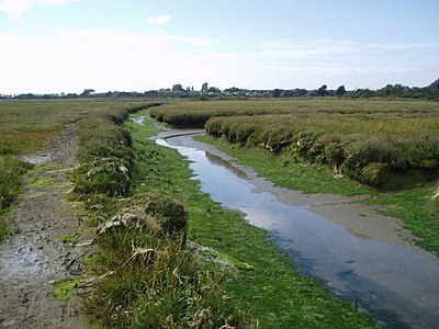
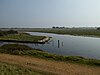
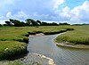
Chichester Harbour is a large natural harbour in West Sussex and Hampshire. It is situated to the south-west of the city of Chichester and to the north of the Solent. The harbour and surrounding land has been designated as an Area of Outstanding Natural Beauty (AONB) and a biological and geological Site of Special Scientific Interest (SSSI). The area is also part of the Solent Maritime Special Area of Conservation, Chichester and Langstone Harbours Ramsar site, Special Protection Area and Nature Conservation Review site, Grade I. Part of it is a Geological Conservation Review site and two areas are Local Nature Reserves.

<span class="mw-page-title-main">Pilsey Island</span>

Pilsey Island is a 17.8-hectare (44-acre) Local Nature Reserve in Chichester Harbour in West Sussex. It is owned by the Ministry of Defence and managed by the Royal Society for the Protection of Birds. It is part of the Chichester Harbour Site of Special Scientific Interest and Nature Conservation Review site, Grade I*, the Chichester and Langstone Harbours Ramsar site and Special Protection Area, and the Solent Maritime Special Area of Conservation.

<span class="mw-page-title-main">Sussex Wildlife Trust</span> Conservation charity which aims to protect natural life

The Sussex Wildlife Trust (SWT) is a conservation charity which aims to protect natural life in Sussex. It was founded in 1961 and is one of 46 wildlife trusts across the UK and the Isle of Man and Alderney. As of 2019, it has 33,000 members and manages 2,000 hectares of land for nature. It is a registered charity and in the year to 31 March 2019 it had an income of £5.7 million and expenditure of £4 million, resulting in net income of £1.7 million.

<span class="mw-page-title-main">Langstone Harbour</span> Site of Special Scientific Interest in Hampshire

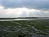
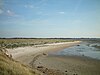
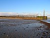
Langstone Harbour is a 2,085.4-hectare (5,153-acre) biological Site of Special Scientific Interest in Hampshire. It is an inlet of the English Channel in Hampshire, sandwiched between Portsea Island to the south and west, Hayling Island to the south and east, and Langstone to the north. It is part of Chichester and Langstone Harbours Ramsar site, Special Protection Area and Nature Conservation Review site, Grade I. Parts of it are in Solent Maritime and Solent and Isle of Wight Lagoons Special Areas of Conservation. Three areas are Local Nature Reserves, Farlington Marshes West Hayling and The Kench, Hayling Island. Two areas are nature reserves managed by the Hampshire and Isle of Wight Wildlife Trust, Farlington Marshes and Southmoor Nature Reserve

<span class="mw-page-title-main">Pagham Harbour</span> Former harbour now nature reserve in southern England

Pagham Harbour is a 629-hectare (1,550-acre) biological and geological Site of Special Scientific Interest on the western outskirts of Bognor Regis in West Sussex. It is a Geological Conservation Review site, a Nature Conservation Review site, a Ramsar site, a Special Protection Area and a Marine Conservation Zone. An area of 599.1 hectares is a Local Nature Reserve.

<span class="mw-page-title-main">Hayling Billy</span>

Hayling Billy is a 42-hectare (100-acre) Local Nature Reserve on Hayling Island in Hampshire. It is owned by Hampshire County Council and managed by Hampshire Countryside Service. It is part of Chichester and Langstone Harbours Ramsar site and Special Protection Area, Solent Maritime Special Area of Conservation and Langstone Harbour Site of Special Scientific Interest.

<span class="mw-page-title-main">Farlington Marshes</span>

Farlington Marshes is a 119.7-hectare (296-acre) Local Nature Reserve in Portsmouth in Hampshire. It is owned by Portsmouth City Council and managed by Hampshire and Isle of Wight Wildlife Trust. It is part of Langstone Harbour, which is a Site of Special Scientific Interest and a Nature Conservation Review site, Grade I. It is also part of Solent Maritime Special Area of Conservation and of Chichester and Langstone Harbours Ramsar site and Special Protection Area.

<span class="mw-page-title-main">Rye Harbour LNR</span> Nature reserve in East Sussex, England

Rye Harbour LNR is a 325.4-hectare (804-acre) Local Nature Reserve in Rye in East Sussex. The site is part of the 465-hectare (1,150-acre) nature reserve managed by the Sussex Wildlife Trust. It is also part of Dungeness, Romney Marsh and Rye Bay Ramsar site, Special Protection Area and Site of Special Scientific Interest and Dungeness Special Area of Conservation.

<span class="mw-page-title-main">Eames Farm</span> Nature reserve in West Sussex

Eames Farm is a 132.5-hectare (327-acre) Local Nature Reserve on Thorney Island in West Sussex. It is owned by the Chichester Harbour Conservancy, West Sussex County Council and the Ministry of Defence and managed by the Chichester Harbour Conservancy. It is part of Chichester and Langstone Harbours Ramsar site and Special Protection Area and Chichester Harbour Site of Special Scientific Interest.

<span class="mw-page-title-main">Nutborne Marshes</span>

Nutborne Marshes is a 386.9-hectare (956-acre) Local Nature Reserve east of Thorney Island in West Sussex. It is owned and managed by Chichester Harbour Conservancy. It is part of the Chichester Harbour Site of Special Scientific Interest and Nature Conservation Review site, Grade I*, the Chichester and Langstone Harbours Ramsar site and Special Protection Area, and the Solent Maritime Special Area of Conservation.

<span class="mw-page-title-main">Gutner Point</span>

Gutner Point is a 69-hectare (170-acre) Local Nature Reserve on Hayling Island in Hampshire. It is owned by Hampshire County Council and managed by Hampshire Countryside Service. It is part of Chichester and Langstone Harbours Ramsar site and Special Protection Area, of Solent Maritime Special Area of Conservation, and of Chichester Harbour Site of Special Scientific Interest.

<span class="mw-page-title-main">The Kench, Hayling Island</span>

The Kench, Hayling Island is a 6-hectare (15-acre) Local Nature Reserve on Hayling Island in Hampshire. It is owned by Hampshire County Council and managed by Hampshire Countryside Service. It is part of Chichester and Langstone Harbours Ramsar site and Special Protection Area, Solent Maritime Special Area of Conservation and Langstone Harbour Site of Special Scientific Interest.

<span class="mw-page-title-main">West Hayling</span>

West Hayling is a 76.2-hectare (188-acre) Local Nature Reserve on Hayling Island in Hampshire. It is owned by Havant Borough Council and managed by the council and the Royal Society for the Protection of Birds. It is part of Langstone Harbour, which is a Site of Special Scientific Interest. It is also part of Solent Maritime Special Area of Conservation and of Chichester and Langstone Harbours Ramsar site and Special Protection Area.

<span class="mw-page-title-main">Southmoor Nature Reserve</span>

Southmoor Nature Reserve is a 11-hectare (27-acre) nature reserve in Havant in Hampshire. It is managed by the Hampshire and Isle of Wight Wildlife Trust. It is part of Langstone Harbour, which is a Site of Special Scientific Interest and a Nature Conservation Review site, Grade I. It is also part of Solent Maritime Special Area of Conservation and of Chichester and Langstone Harbours Ramsar site and Special Protection Area.

References

  1. "Protected or designated areas". Department for Environment, Food & Rural Affairs and Natural England. 9 April 2013. Archived from the original on 4 May 2015. Retrieved 29 July 2015.
  2. "Local nature reserves: setting up and management". Department for Environment, Food & Rural Affairs and Natural England. 2 October 2014. Archived from the original on 4 July 2015. Retrieved 29 July 2015.
  3. "Designated Sites View: West Sussex". Local Nature Reserves. Natural England. Archived from the original on 27 March 2019. Retrieved 21 March 2019.
  4. "West Sussex Quick Facts". West Sussex.info. Archived from the original on 25 October 2018. Retrieved 17 July 2019.
  5. "West Sussex". Encyclopædia Britannica. Encyclopædia Britannica Inc. Archived from the original on 2 April 2019. Retrieved 18 July 2019.
  6. "Local Nature Reserves: Search results for Norfolk". Natural England. Archived from the original on 22 May 2018. Retrieved 31 October 2018.
  7. "Designated Sites View: Ardingly Reservoir". Local Nature Reserves. Natural England. Archived from the original on 27 March 2019. Retrieved 23 July 2019.
  8. "Ashenground and Bolnore Woods". Local Nature Reserves. Natural England. Archived from the original on 27 March 2019. Retrieved 10 April 2019.
  9. "Bedelands Farm Nature Reserve". Local Nature Reserves. Natural England. Archived from the original on 27 March 2019. Retrieved 24 July 2019.
  10. "Blunts Wood and Paiges Meadow". Local Nature Reserves. Natural England. Archived from the original on 27 March 2019. Retrieved 11 April 2019.
  11. "Chichester Dyke, Broyle earthwork, section extending 430yds (393m) through East Broyle Copse, to railway, and earthwork extending 400yds (365m) from Brandy Hole Lane, New Fishbourne". Historic England. Archived from the original on 24 July 2019. Retrieved 24 July 2019.
  12. "Brandy Hole Copse". Local Nature Reserves. Natural England. Archived from the original on 27 March 2019. Retrieved 24 July 2019.
  13. "The Brooks Local Nature Reserve". Local Nature Reserves. Natural England. Archived from the original on 27 March 2019. Retrieved 20 May 2019.
  14. "Designated Sites View: Burton Park". Sites of Special Scientific Interest. Natural England. Retrieved 6 April 2019.
  15. "Burton and Chingford Ponds". Sussex Wildlife Trust. Retrieved 8 April 2019.
  16. "Burton Park citation" (PDF). Sites of Special Scientific Interest. Natural England. Retrieved 19 April 2019.
  17. 1 2 3 Ratcliffe, pp. 3–4
  18. "Designated Sites View: Chichester and Langstone Harbours". Ramsar Site. Natural England. Archived from the original on 1 April 2019. Retrieved 1 April 2019.
  19. "Designated Sites View: Chichester and Langstone Harbours". Special Protection Areas. Natural England. Archived from the original on 1 April 2019. Retrieved 1 April 2019.
  20. "Designated Sites View: Chichester Harbour". Sites of Special Scientific Interest. Natural England. Archived from the original on 1 April 2019. Retrieved 1 April 2019.
  21. "Our land". Chichester Harbour Trust. Archived from the original on 1 April 2019. Retrieved 1 April 2019.
  22. "Eastern Road Nature Reserve". Local Nature Reserves. Natural England. Archived from the original on 27 March 2019. Retrieved 11 April 2019.
  23. "Designated Sites View: Fairmile Bottom". Sites of Special Scientific Interest. Natural England. Retrieved 7 April 2019.
  24. "Designated Sites View: Fairmile Bottom". Local Nature Reserves. Natural England. Retrieved 6 April 2019.
  25. "Grattons Park". Local Nature Reserves. Natural England. Archived from the original on 27 March 2019. Retrieved 28 April 2019.
  26. Ratcliffe, p. 118
  27. "Designated Sites View: Harting Downs". Sites of Special Scientific Interest. Natural England. Retrieved 7 April 2019.
  28. "Harting Down". Local Nature Reserves. Natural England. Archived from the original on 27 March 2019. Retrieved 30 April 2019.
  29. Ratcliffe, p. 119
  30. "Designated Sites View: Iping Common". Sites of Special Scientific Interest. Natural England. Retrieved 7 April 2019.
  31. "Iping and Stedham Commons". Sussex Wildlife Trust. Archived from the original on 1 April 2019. Retrieved 11 April 2019.
  32. "Iping Common citation" (PDF). Sites of Special Scientific Interest. Natural England. Archived (PDF) from the original on 21 March 2019. Retrieved 1 May 2019.
  33. "Lancing Ring". Local Nature Reserves. Natural England. Archived from the original on 27 March 2019. Retrieved 25 July 2019.
  34. "Lynchmere Commons". Local Nature Reserves. Natural England. Archived from the original on 27 March 2019. Retrieved 25 July 2019.
  35. "Mill Hill". Local Nature Reserves. Natural England. Archived from the original on 27 March 2019. Retrieved 25 July 2019.
  36. 1 2 "Designated Sites View: Chichester and Langstone Harbours". Ramsar Site. Natural England. Archived from the original on 1 April 2019. Retrieved 6 April 2019.
  37. 1 2 "Designated Sites View: Solent Maritime". Special Areas of Conservation. Natural England. Retrieved 6 April 2019.
  38. 1 2 "Designated Sites View: Chichester and Langstone Harbours". Special Protection Areas. Natural England. Archived from the original on 1 April 2019. Retrieved 6 April 2019.
  39. 1 2 "Designated Sites View: Chichester Harbour". Sites of Special Scientific Interest. Natural England. Retrieved 6 April 2019.
  40. "Nutborne Marshes". Local Nature Reserves. Natural England. Archived from the original on 27 March 2019. Retrieved 25 July 2019.
  41. 1 2 "Designated Sites View: Pagham Harbour". Sites of Special Scientific Interest. Natural England. Retrieved 7 April 2019.
  42. "Designated Sites View: Pagham Harbour". Ramsar Site. Natural England. Retrieved 6 April 2019.
  43. "Designated Sites View: Pagham Harbour". Special Protection Areas. Natural England. Retrieved 6 April 2019.
  44. "Pagham Harbour citation" (PDF). Sites of Special Scientific Interest. Natural England. Archived (PDF) from the original on 6 May 2019. Retrieved 6 May 2019.
  45. "Pilsey Island". Local Nature Reserves. Natural England. Archived from the original on 27 March 2019. Retrieved 25 July 2019.
  46. "The Scrase Valley". Local Nature Reserves. Natural England. Retrieved 11 April 2019.
  47. "Shoreham Beach". Local Nature Reserves. Natural England. Archived from the original on 27 March 2019. Retrieved 26 July 2019.
  48. "Target Hill Park". Local Nature Reserves. Natural England. Retrieved 29 April 2019.
  49. "Tilgate Forest". Local Nature Reserves. Natural England. Archived from the original on 27 March 2019. Retrieved 26 July 2019.
  50. "Tottington Wood". Local Nature Reserves. Natural England. Archived from the original on 27 March 2019. Retrieved 11 April 2019.
  51. "Warnham LNR". Local Nature Reserves. Natural England. Archived from the original on 27 March 2019. Retrieved 26 July 2019.
  52. "Designated Sites View: Climping Beach". Sites of Special Scientific Interest. Natural England. Retrieved 7 April 2019.
  53. "Climping Beach citation" (PDF). Sites of Special Scientific Interest. Natural England. Retrieved 22 April 2019.
  54. "Widewater Lagoon". Local Nature Reserves. Natural England. Retrieved 26 July 2019.

Sources

Coordinates: 50°55′N0°30′W / 50.917°N 0.500°W / 50.917; -0.500