
The Hooghly River or popularly called Ganga or Kati-Ganga in the Puranas, is a river that rises close to Giria, which lies north of Baharampur and Palashi in Murshidabad. It is the western distributary of the Ganges. The main course of the Ganges then flows into Bangladesh as the Padma. A man-made canal, built in the 1960s and early-1970s at Farakka, connects the Ganges, flowing through Malda, to the Hooghly to bring the abundant waters of the Himalayan river to the comparatively narrow river that rises in eastern West Bengal.

The Geography of West Bengal, a state in eastern India, is primarily defined by plains and plateaus, with the high peaks of the Himalayas in the north and the Bay of Bengal to the south.

Taki is a city and a municipality under the Hasnabad police station of the Basirhat subdivision in North 24 Parganas district in the Indian state of West Bengal.
Deganga is a community development block that forms an administrative division in North 24 Parganas district in the Indian state of West Bengal.
Bidyadhari River, is a river in the Indian state of West Bengal. It originates near Haringhata in Nadia district and then flows through Deganga, Habra and Barasat areas of North 24 Parganas before joining the Raimangal River in the Sundarbans.

Matla River forms a wide estuary in and around the Sundarbans in South 24 Parganas district in the Indian state of West Bengal.
Thakuran River is a tidal estuarine river that forms a wide estuary in and around the Sundarbans in South 24 Parganas district in the Indian state of West Bengal.
Raimangal River is a tidal estuarine river in and around the Sundarbans in South 24 Parganas district in the Indian state of West Bengal and Satkhira District in Bangladesh.

Piyali River is a tidal estuarine river in and around the Sundarbans in South 24 Parganas district in the Indian state of West Bengal.
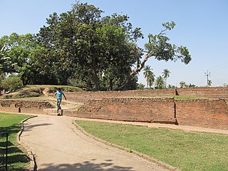
Berachampa Deulia, or commonly known as Berachampa, is a census town in the Deganga CD block in the Barasat Sadar subdivision in the Deganga CD block of the North 24 Parganas district in the Indian state of West Bengal. The ancient archaeological site of Chandraketugarh, circa 300 BCE, is located near Berachampa. Deulia and Deganga are located nearby. Berachampa is the business center of the area and the most important junction between Barasat and Basirhat. The area is administered by Berachampa Gram Panchayat no. II. The wider Berachampa circle consists of two gram panchayats namely Berachampa Gram Panchayat No. I and Berachampa Gram Panchayat No. II.
Hasnabad is a village and a gram panchayat in the Hasnabad CD block in the Hasnabad subdivision of the North 24 Parganas district in the state of West Bengal, India.Hasnabad is called the' Second Gateway of Sunderban'.
Kudghat is a neighbourhood of South Kolkata in the Indian state of West Bengal. It is a part of greater Tollygunge region. The region is divided into two parts, purba putiary and paschim putiary.
Hingalganj is a census town in the Hingalganj CD block in the Basirhat subdivision of the North 24 Parganas district in the state of West Bengal, India.
Nazat is a village and a gram panchayat in the Sandeshkhali I CD block in the Basirhat subdivision of the North 24 Parganas district in the state of West Bengal, India.
Malancha is a village in the Minakhan CD block in the Basirhat subdivision of the North 24 Parganas district in the state of West Bengal, India.
Kalaria is a census town within the jurisdiction of the Canning police station in the Canning I CD block in the Canning subdivision of the South 24 Parganas district in the Indian state of West Bengal.
Banshra is a census town and a gram panchayat within the jurisdiction of the Canning police station in the Canning I CD block in the Canning subdivision of the South 24 Parganas district in the Indian state of West Bengal.
Ghojadanga is a border checkpoint in the Basirhat II CD block in the Basirhat subdivision of the North 24 Parganas district in the state of West Bengal, India.
This page is based on this
Wikipedia article Text is available under the
CC BY-SA 4.0 license; additional terms may apply.
Images, videos and audio are available under their respective licenses.

