Mansehra District is a district in the Hazara Division, Khyber Pakhtunkhwa, northern Pakistan. Mansehra city serves as the headquarters of the district.

Karak District is a district in Kohat Division of Khyber Pakhtunkhwa province in Pakistan. It is situated to the south of Kohat District and on the north side of Bannu and Lakki Marwat districts on the main Indus Highway between Peshawar and Karachi – it is 131 km from the provincial capital Peshawar. It gained a district status in 1982, prior to which it was part of Kohat District.

North Waziristan District is a district of Khyber Pakhtunkhwa province in Pakistan. It is the northern part of Waziristan, a mountainous region of northwest Pakistan, bordering Afghanistan and covering 4,707 square kilometres (1,817 sq mi). The capital city of North Waziristan is Miranshah.
The Tarkani or Tarkalani are a Pashtun tribe mainly settled in Bajaur District, Lower Dir district, Barawal upper dir and in Kabal and Matta tehsil of district Swat Pakistan but originally hailed from the Laghman province of modern-day Afghanistan.

Parachinar is a town and the capital of the Kurram District in the province of Khyber Pakhtunkhwa, Pakistan. It is mainly inhabited by Pashtun.

Lakki Marwat or Lakki is the headquarters of Lakki Marwat District in Khyber Pakhtunkhwa province of Pakistan. Lakki Marwat has become one of the fastest growing cities in Khyber Pakhtunkhwa. Lakki Marwat is also the 20th most populous city in the province of Khyber Pakhtunkhwa.

Orakzai District is a district in the Kohat Division of the Khyber Pakhtunkhwa province of Pakistan. Before 1973, it was part of FR Kohat. Up until 2018, it was an agency within the erstwhile Federally Administered Tribal Areas. However, with the merger of the FATA with Khyber Pakhtunkhwa, it attained the status of a district.

Lakki Marwat is a district in the Bannu Division of the Khyber Pakhtunkhwa province of Pakistan. It was created as an administrative district on July 1, 1992, prior to which it was a tehsil of the Bannu District.

Khyber District is a district in the Peshawar Division of the Khyber Pakhtunkhwa province of Pakistan. Until 2018, it was an agency of the erstwhile Federally Administered Tribal Areas. With the merger of FATA with Khyber Pakhtunkhwa in 2018, it became a district. It ranges from the Tirah valley down to Peshawar. It borders Nangarhar Province to the west, Orakzai District to the south, Kurram District to southwest, Peshawar to the east and Mohmand District to the north.
Kohat Division is one of the seven divisions in the Khyber Pakhtunkhwa province of Pakistan. It consists of five districts: Hangu, Karak, Kohat, Kurram, and Orakzai. According to the 2017 Census of Pakistan, the division had a population of 3,211,458, making it the third-least populous division in the province. Its area is 12,377 km2 (4,779 sq mi). Thus, it is also the fourth-largest division by area in the province. Kohat is the division's largest city and its namesake. Kohat city has a population of 220,000. The division borders Bannu Division to the south and west, Peshawar Division to the north and east, the province of Punjab to the east, and Afghanistan to the northwest.
Kurram District is a district in the Kohat Division of the Khyber Pakhtunkhwa province of Pakistan.The name Kurram comes from the river Kuramá in Pashto which itself derives from the Sanskrit word Krumuḥ.
Khaglan Wala (ڪھگلانواله) is a village and union council of Isakhel Tehsil of Mianwali District in the Punjab province of Pakistan. It is part of Isa Khel Tehsil and is located at 32°37'60N 71°16'0E. It is located on the northern bank of Kurram River. It is one of the villages situated on the western borders of Punjab province adjacent to KPK province. Its population is about 3000 people. It is a comparatively developed village as basic facilities like electricity, telephone, metalled road, internet, schools, water supply system and sewerage system are provided to the inhabitants of this village. It is also a well-planned village situated on a 40 feet wide road. A 30' main street runs east to west through the village by equally dividing the entire village into two parts. Three other streets run north to south crossing the main street at 90°. There are four mosques i.e Grand Mosque, Masjid Naurang Khel, Masjid Khizar Khel in Mohalla Khizar Khel and Masjid Abadi Tajpora in this settlement. The scene of river Kurram alongside bela jungle give beautiful look to this historical village. Khaglanwala is a hub of different routes coming from various villages situated on other side of the River Kurram to reach Isa Khel city.

The Orakzai and Kurram offensive, also known as Operation Khwakh Ba De Sham was a Pakistani military operation against the Tehrik-i-Taliban in the Orakzai Agency and Kurram Agency area of the Federally Administered Tribal Areas that began on 23 March 2010. It was part of the War in North-West Pakistan.
This is a list of terrorist incidents in Pakistan in 2012. Pakistan has faced numerous attacks by insurgents as a result of the ongoing War in North-West Pakistan by the Pakistani military against militant groups, part of the War on Terror. At the same time, there have also been numerous drone attacks in Pakistan carried out by the United States which exclusively target members of militant groups along the Afghan border regions.
{settlement | official_name = manglawar | name = Manglawar
| nickname = manglawar | image_skyline = File:Night over the Village.jpg | image_caption = View of the village | settlement_type = Union council | image_alt = | imagesize = 300px | image_map = | mapsize = 100px | map_alt = Showing Manglawar in Pakistan | map_caption = Showing Manglawar in Pakistan | coordinates = 34.47°N 72.43°E | pushpin_map = Pakistan | pushpin_label_position = | pushpin_map_alt = | pushpin_mapsize = | pushpin_map_caption = | subdivision_type = Country | subdivision_name = Pakistan | subdivision_type1 = Province | subdivision_name1 = Khyber-Pakhtunkhwa | subdivision_type2 = District | subdivision_name2 = Swat | subdivision_type3 = Tehsil | subdivision_name3 = Tehsil Babuzai | subdivision_type4 = Union Council | subdivision_name4 = Union Council Manglawar | subdivision_type5 = Ward (KPK) | subdivision_name5 = Ward Manglawar | subdivision_type6 = Village Council (KPK) | subdivision_name6 = *VC Manglawar East
Lower Kohistan District is a district in the Hazara Division of the Khyber Pakhtunkhwa province of Pakistan. The district headquarters of Lower Kohistan is Pattan.

Kolai-Pallas District is a district in the Hazara Division of the Khyber Pakhtunkhwa province of Pakistan. It was a sub-division of the Kohistan district within the Hazara division till it attained the status of a separate district in 2017.
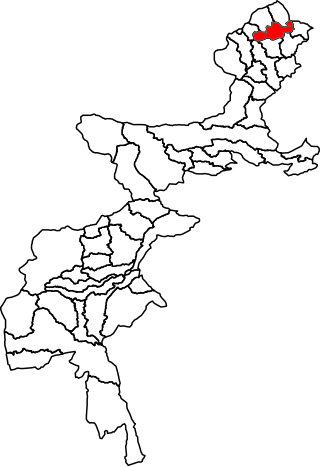
Baffa Pakhal is the fourth tehsil of Mansehra District in Khyber Pakhtunkhwa province of Pakistan. . The capital of Baffa pakhal is Baffa. Baffa Pakhal has at least 15 union councils, some of which are Dodial, Shinkiari, Suma Allimung, Schain, Jabar Daveli, Ichrian, Ail, Tanda, Baffa, Anayatabad, Hilkot, Tarangri Sabir Shah and Bhogarmang. Main language of the tehsil is Pashto followed by Hindko. Majority of lands in all Union Councils of Baffa Pakhal belongs to 8 families of Gabri Swatis.
Khar Bajaur Tehsil is a subdivision located in Bajaur District, Khyber Pakhtunkhwa, Pakistan. It starts in Jar to Zorbandar (east–west) and Tangai to Inzari (northwest–southwest) and A Inayat kali to Mandalu (northeast–southeast).