
Hornsey is a district of north London, England, in the London Borough of Haringey. It is an inner-suburban, for the most part residential, area centred 10 km (6.2 mi) north of Charing Cross. It adjoins green spaces Queen's Wood to the west and Alexandra Park to the north, and lies in the valley of the now-culverted River Moselle. The central core of the area is known as Hornsey Village.

Neasden is a suburban area in northwest London, England. It is located around the centre of the London Borough of Brent and is within the NW2 (Cricklewood) and NW10 (Willesden) postal districts. Neasden is near Wembley Stadium, the Welsh Harp, and Gladstone Park; the reservoir and River Brent marks its boundaries with Kingsbury and Wembley, while Gladstone Park and the Dudding Hill line separates it from Dollis Hill and Church End respectively. The A406 North Circular Road runs through the middle of Neasden; to the west is the Neasden Underground Depot, Brent Park retail area and the St Raphael's Estate; on the east is Neasden tube station, the large Neasden Temple, and former Neasden Power Station. The area is known as the place where Bob Marley lived after moving from Jamaica, living at a house in The Circle; the house was honoured with a blue plaque in 2012.

Palmers Green is a suburban area and electoral ward in North London, England, within the London Borough of Enfield. It is located within the N13 postcode district, around 8 miles (13 km) north of Charing Cross. It is home to the largest population of Greek Cypriots outside Cyprus and is often nicknamed "Little Cyprus" or "Palmers Greek".

Tottenham Court Road is a major road in Central London, almost entirely within the London Borough of Camden.

Oxford Street is a major road in the City of Westminster in the West End of London, running from Tottenham Court Road to Marble Arch via Oxford Circus. It is Europe's busiest shopping street, with around half a million daily visitors, and as of 2012 had approximately 300 shops. It is designated as part of the A40, a major road between London and Fishguard, though it is not signed as such, and traffic is regularly restricted to buses and taxis.

Euston Road is a road in Central London that runs from Marylebone Road to King's Cross. The route is part of the London Inner Ring Road and forms part of the London congestion charge zone boundary. It is named after Euston Hall, the family seat of the Dukes of Grafton, who had become major property owners in the area during the mid-19th century.
Seven Sisters is a district of Tottenham, north London, England, at the eastern end of Seven Sisters Road, which runs from Tottenham High Road to join the A1 in Holloway.

Kidsgrove is a town in the borough of Newcastle-under-Lyme, Staffordshire, England, on the Cheshire border. It is part of the Potteries Urban Area, along with Stoke-on-Trent and Newcastle-under-Lyme. It has a population of 26,276. Most of the town is in the Kidsgrove ward, whilst the western part is in Ravenscliffe.

North Finchley is a suburb of London in the London Borough of Barnet, situated 7 miles (11 km) north-west of Charing Cross.
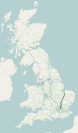
The A10 is a major road in England which runs between The City of London and King's Lynn in Norfolk.

White Hart Lane was a football stadium in Tottenham, North London and the home of Tottenham Hotspur Football Club from 1899 to 2017. Its capacity varied over the years; when changed to all-seater it had a capacity of 36,284. The stadium was fully demolished after the end of the 2016–17 season.

The Lea Valley lines are two commuter lines and two branches in north-east London, so named because they run along the Lower Lea Valley of the River Lea. They were part of the Great Eastern Railway, now part of the Anglia Route of Network Rail.

Edmonton is a town in north London, England within the London Borough of Enfield, a local government district of Greater London. The northern part of the town is known as Lower Edmonton or Edmonton Green, and the southern part as Upper Edmonton. Situated 8.4 miles (13.5 km) north-northeast of Charing Cross, it borders Enfield to the north, Chingford to the east, and Tottenham to the south, with Palmers Green and Winchmore Hill to the west. The population of Edmonton was 82,472 as of 2011.

Bruce Castle is a Grade I listed 16th-century manor house in Lordship Lane, Tottenham, London. It is named after the House of Bruce who formerly owned the land on which it is built. Believed to stand on the site of an earlier building, about which little is known, the current house is one of the oldest surviving English brick houses. It was remodelled in the 17th, 18th and 19th centuries.
Picketts Lock or Pickett's Lock is an area of Edmonton, in the London Borough of Enfield. It is bordered by River Lee Navigation to the east, Pickett's Lock Lane to the south, Meridian Way A1055 to the west and the Ponders End industrial area to the north. The area takes its name from Pickett's Lock, a lock on the nearby River Lee Navigation.

Tottenham is a town in north London, England, within the London Borough of Haringey. It is located in the ceremonial county of Greater London. Tottenham is centred 6 mi (10 km) north-northeast of Charing Cross, bordering Edmonton to the north, Walthamstow, across the River Lea, to the east, and Stamford Hill to the south, with Wood Green and Harringay to the west.

London Buses route 149 is a Transport for London contracted bus route in London, England. Running between Edmonton Green and London Bridge bus stations, it is operated by Arriva London.
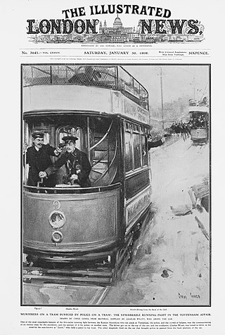
The Tottenham Outrage of 23 January 1909 was an armed robbery in Tottenham, North London, that resulted in a two-hour chase between the police and armed criminals over a distance of six miles (10 km), with an estimated 400 rounds of ammunition fired by the thieves. The robbery, of workers' wages from the Schnurmann rubber factory, was carried out by Paul Helfeld and Jacob Lepidus, Jewish Latvian immigrants. Of the twenty-three casualties, two were fatal and several others serious, among them seven policemen. The two thieves killed themselves at the end of the pursuit.

Media in Manchester has been an integral part of Manchester's culture and economy for many generations and has been described as the only other British city to rival to London in terms of television broadcasting. Today, Manchester is the second largest centre of the creative and digital industries in Europe.

51.5976°N 0.0704°W


