
Wood Green is a suburban district in the borough of Haringey in London, England. Its postal district is N22, with parts in N8 or N15. The London Plan identifies it as one of the metropolitan centres in Greater London, and today it forms a major commercial district of north London.

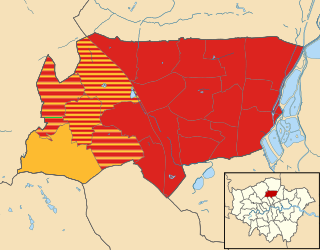
The London Borough of Haringey is a London borough in north London, classified by some definitions as part of Inner London, and by others as part of Outer London. It was created in 1965 by the amalgamation of three former boroughs. It shares borders with six other London boroughs. Clockwise from the north, they are: Enfield, Waltham Forest, Hackney, Islington, Camden, and Barnet.
Seven Sisters is a district of Tottenham, north London, England, at the eastern end of Seven Sisters Road, which runs from Tottenham High Road to join the A1 in Holloway.
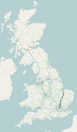
The A10 is a major road in England which runs between The City of London and King's Lynn in Norfolk.

Crouch End is an area of North London, approximately five miles (8 km) from the City of London in the western half of the borough of Haringey. It is within the Hornsey postal district (N8). It has been described by the BBC as one of "a new breed of urban villages" in London. In 2023, it was voted the best place to live in London by the Sunday Times, saying "A creative edge and friendly neighbours give this lofty northern enclave social capital in the capital".
Harringay is a district of north London, England, within the London Borough of Haringey. It is centred on the section of Green Lanes running between the New River, where it crosses Green Lanes by Finsbury Park, and Duckett's Common, near Turnpike Lane.

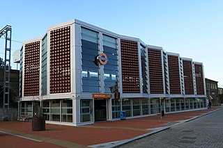
Seven Sisters is an interchange station located in the Seven Sisters area of the London Borough of Haringey, North London for London Underground, London Overground and National Rail services.

South Tottenham is a railway station on the east–west Gospel Oak to Barking line of the London Overground. It is located on the eastern side of the north–south A10 High Road in Tottenham, North London, 5 miles 69 chains (9.4 km) from St Pancras and situated between Harringay Green Lanes and Blackhorse Road. It is in Zone 3, in the London Borough of Haringey. South Tottenham to Seven Sisters station is considered an official out-of-station interchange by the National Rail timetable, and involves a short walk. This link will become fixed under the planned route for Crossrail 2, which sees a double-ended underground station built linking together South Tottenham and Seven Sisters stations.

Tottenham Hale is a district of north London and part of the London Borough of Haringey, bounded by the River Lea and located to the south/south-east of Tottenham proper. From 1850 to 1965, it was part of the Municipal Borough of Tottenham, in Middlesex.
White Hart Lane is a London Overground station on the Lea Valley lines located in Tottenham of the London Borough of Haringey in North London. It is 7 miles 11 chains (11.5 km) from London Liverpool Street and is situated between Bruce Grove and Silver Street. It is in Travelcard zone 3.

Bruce Grove is a London Overground station on the Lea Valley lines located in central Tottenham in the London Borough of Haringey, north London. It is 6 miles 28 chains (10.2 km) down the line from London Liverpool Street and is situated between Seven Sisters and White Hart Lane. Its three-letter station code is BCV and it is in Travelcard zone 3.

The Lea Valley lines are two commuter lines and three branches in north-east London, so named because they run along the Lower Lea Valley of the River Lea. They were part of the Great Eastern Railway, now part of the Anglia Route of Network Rail.

Tottenham is a constituency in Greater London represented in the House of Commons of the Parliament of the United Kingdom since 2000 by the current Foreign Secretary, David Lammy of the Labour Party. Lammy has also served as the Shadow Foreign Secretary from 2021 to 2024 in the Shadow Cabinet of Keir Starmer, in which he previously served as Shadow Secretary of State for Justice and Shadow Lord Chancellor from 2020 to 2021. Tottenham was re-created as a parliamentary constituency in 1950, having previously existed from 1885 to 1918.

Tottenham High Road is the main thoroughfare through the district of Tottenham, in the London Borough of Haringey. It runs from Edmonton in the North to Stamford Hill in the South. South of Bruce Grove the road is part of the A10; to the north it is part of the A1010. Tottenham High Road passes through the London postcode areas of N17 and N15 and is 2.3 miles in length.

West Green is a district in north London, England, in the United Kingdom; within the London Borough of Haringey. It is located 5.7 miles (9.22 km) north of Charing Cross.
Northumberland Park is a ward in the Tottenham area of London Borough of Haringey, in Greater London, England. It is largely residential, consisting of houses and flats. It is the location of Tottenham Hotspur Stadium, the home ground of Tottenham Hotspur F.C. The ward is represented by three Labour councillors. It is named after the Northumberland family who originally owned the land, the family included Harry Hotspur, who Tottenham Hotspur Football Club are named after.

Tottenham is a town in north London, England, within the London Borough of Haringey. It is located in the ceremonial county of Greater London. Tottenham is centred 6 mi (10 km) north-northeast of Charing Cross, bordering Edmonton to the north, Walthamstow, across the River Lea, to the east, and Stamford Hill to the south, with Wood Green and Harringay to the west.
St Ann's is a neighbourhood in Tottenham, north London, England, in the London Borough of Haringey. It is located to the east of Harringay and West Green and is within, but distinct from, St Ann's ward.
The 1974 Haringey Council election took place on 2 May 1974 to elect members of Haringey London Borough Council in London, England. The whole council was up for election and the Labour party stayed in overall control of the council.
The 2022 Haringey London Borough Council election took place on 5 May 2022. All 57 members of Haringey London Borough Council were elected. The elections took place alongside local elections in the other London boroughs and elections to local authorities across the United Kingdom.


