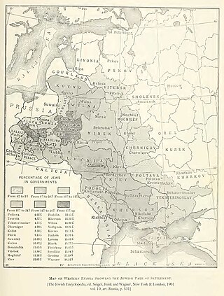
The Pale of Settlement was a western region of the Russian Empire with varying borders that existed from 1791 to 1917 in which permanent residency by Jews was allowed and beyond which Jewish residency, permanent or temporary, was mostly forbidden. Most Jews were still excluded from residency in a number of cities within the Pale as well. A few Jews were allowed to live outside the area, including those with university education, the ennobled, members of the most affluent of the merchant guilds and particular artisans, some military personnel and some services associated with them, including their families, and sometimes their servants. The archaic English term pale is derived from the Latin word palus, a stake, extended to mean the area enclosed by a fence or boundary.
A governorate was a major and principal administrative subdivision of the Russian Empire. After the Bolshevik Revolution in 1917, governorates remained as subdivisions in the Byelorussian, Russian and Ukrainian Soviet republics, and in the Soviet Union from its formation in 1922 until 1929. The term is also translated as government or province. A governorate was headed by a governor, a word borrowed from Latin gubernator, in turn from Greek κυβερνήτης.

Right-bank Ukraine is a historical and territorial name for a part of modern Ukraine on the right (west) bank of the Dnieper River, corresponding to the modern-day oblasts of Vinnytsia, Zhytomyr, Kirovohrad, as well as the western parts of Kyiv and Cherkasy. It was separated from the left bank during the Ruin.

The modern administrative-territorial structure of Russia is a system of territorial organization which is a product of a centuries-long evolution and reforms.

Taurida Governorate was an administrative-territorial unit (guberniya) of the Russian Empire. It included the territory of the Crimean Peninsula and the mainland between the lower Dnieper River with the coasts of the Black Sea and Sea of Azov. It formed after Taurida Oblast was abolished in 1802 during the course of Paul I's administrative reform of the territories of the former Crimean Khanate which were annexed by Russia in 1783. The governorate's centre was the city of Simferopol. The name of the province was derived from Taurida, a historical name for Crimea.

Podolia Governorate was an administrative-territorial unit (guberniya) of the Southwestern Krai of the Russian Empire. It bordered Volhynian Governorate to the north, Kiev Governorate to the east, Kherson Governorate to the southeast, Bessarabia Governorate to the south, and Austria to the west. Its administrative centre was Kamenets-Podolsky (Kamianets-Podilskyi), which later moved to Vinnitsa (Vinnytsia). The governorate covered areas of Ukraine's partially Khmelnytskyi and most of Vinnytsia Oblasts, along with the fractionally recognised state of Transnistria.

Kherson Governorate, known until 1803 as Nikolayev Governorate, was an administrative-territorial unit (guberniya) of the Russian Empire, with its capital in Kherson. It encompassed 71,936 square kilometres (27,775 sq mi) in area and had a population of 2,733,612 inhabitants. At the time of the census in 1897, it bordered Podolia Governorate to the northwest, Kiev Governorate to the north, Poltava Governorate to the northeast, Yekaterinoslav Governorate to the east, Taurida Governorate to the southeast, Black Sea to the south, and Bessarabia Governorate to the west. It roughly corresponds to what is now most of Mykolaiv, Kirovohrad and Odesa Oblasts in Ukraine and some parts of Kherson and Dnipropetrovsk Oblasts.

Kholm Governorate was an administrative-territorial unit (guberniya) of the Russian Empire, with its capital in Kholm (Chełm).

Poltava Governorate was an administrative-territorial unit (guberniya) of the Russian Empire. It included the territory of left-bank Ukraine and was officially created in 1802 from the disbanded Little Russia Governorate, which was split between Chernigov and Poltava Governorates with its capital in Poltava.

Kharkov Governorate was an administrative-territorial unit (guberniya) of the Russian Empire founded in 1835. It embraced the historical region of Sloboda Ukraine. From 1765 to 1780 and from 1796 to 1835 the governorate was called Sloboda Ukraine Governorate. In 1780-1796 there existed the Kharkov Viceroyalty.

Volhynia Governorate, also known as Volyn Governorate, was an administrative-territorial unit (guberniya) of the Southwestern Krai of the Russian Empire. It consisted of an area of 71,736 square kilometres (27,697 sq mi) and a population of 2,989,482 inhabitants. The governorate bordered Grodno and Minsk Governorates to the north, Kiev Governorate to the east, Podolia Governorate to the south, Lublin and Siedlce Governorates, and after 1912, Kholm Governorate and Austria to the west. Its capital was in Novograd-Volynsky until 1804, and then Zhitomir. It corresponded to most of modern-day Volyn, Rivne and Zhytomyr Oblasts of Ukraine and some parts of Brest and Gomel Regions of Belarus.

Kiev Governorate was an administrative-territorial unit (guberniya) of the Russian Empire from 1796 to 1919 and the Ukrainian Soviet Socialist Republic from 1919 to 1925. It included the territory of the right-bank Ukraine and was formed after a division of the Kiev Viceroyalty into Kiev and Little Russia Governorates in 1796. Its capital was in Kiev. By the early 20th century, it consisted of 12 uyezds, 12 cities, 111 miasteczkos and 7344 other settlements. After the October Revolution, it became part of the administrative division of the Ukrainian SSR. In 1923 it was divided into several okrugs and on 6 June 1925 it was abolished by the Soviet administrative reforms.

Novorossiya Governorate was an administrative-territorial unit (guberniya) of the Russian Empire, which existed in 1764–1783 and again in 1796–1802. It was created and governed according to the "Plan for the Colonization of New Russia Governorate" issued by the Russian Senate. It became the first region in Russia where Catherine the Great allowed foreign Jews to settle.

During its existence from 1919 to 1991, the Ukrainian Soviet Socialist Republic consisted of many administrative divisions. Itself part of the highly centralized Soviet Union, sub-national divisions in the Ukrainian SSR were subordinate to higher executive authorities and derived their power from them. Throughout the Ukrainian SSR's history, other national subdivisions were established in the republic, including guberniyas and okrugs, before finally being reorganized into their present structure as oblasts. At the time of the Ukrainian SSR's independence from the Soviet Union, the country was composed of 25 oblasts (provinces) and two cities with special status, Kiev, the capital, and Sevastopol, respectively.
Azov Governorate was an administrative-territorial unit (guberniya) of the Russian Empire, which existed from 1775 to 1783. Its capital was in Belyov Fortress and later in Yekaterinoslav.

Chernihiv Governorate was an administrative-territorial unit of the Ukrainian State and the Ukrainian SSR, existing from 1918 to 1925. It was inherited from the Russian system of territorial subdivisions that existed prior to World War I. Specifically, Chernigov Governorate, also known as the Government of Chernigov, was an administrative-territorial unit (guberniya) of the Russian Empire. It included the territory of the left-bank Ukraine and was officially created in 1802 from Malorossiya Governorate with its capital in Chernigov (Chernihiv). Little Russian Governorate was transformed into the General Government of Little Russia and consisted of Chernigov Governorate, Poltava Governorate, and later Kharkov Governorate.
Voronezh Governorate was an administrative-territorial unit (guberniya) of the Tsardom of Russia, the Russian Empire, and the Russian SFSR, which existed from 1708 to 1779 and again from 1796 to 1928. Its capital was located in Voronezh since 1725.
Governorates-General were a type of administrative-territorial division in the Russian Empire from 1775–1917. Governorates-General usually comprised a set of guberniyas and oblasts. The term was sometimes used to refer to krais or military guberniyas. The Moscow and Saint-Petersburg governorates were placed into a separate governorate-general.

Kiev Governorate was an administrative-territorial unit (guberniya) of the Tsardom of Russia and the Russian Empire. It was established in December 1708 as one of the eight guberniyas first created during the reforms of Peter the Great.
Novgorod-Seversky Viceroyalty, sometimes Novgorod-Seversky Governorate, was an administrative-territorial unit (namestnichestvo) of the Russian Empire, which existed in 1781-1796. Its capital was in Novgorod-Seversky.