Lliw Valley

Last updated
Lliw Valley
Welsh: Dyffryn Lliw
Borough
Council Offices, Penllergare wood, Swansea - geograph.org.uk - 1764576.jpg
Civic Centre, Penllergaer: Council's headquarters from 1981
Lliw Valley au pays de Galles (1974-1996).svg
History
  Created1 April 1974
  Abolished31 March 1996
  Succeeded by Swansea
Neath Port Talbot
Government
   HQ Penllergaer
   Motto Nid da lle gellir gwell (From good things to better)
Lliwvalley arms.png
Contained within
  County Council West Glamorgan

Lliw Valley (Welsh : Dyffryn Lliw) was a local government district with borough status in West Glamorgan, Wales from 1974 to 1996.

Contents

History

The borough was created on 1 April 1974 under the Local Government Act 1972, which reorganised local government across Wales and England. The new borough covered the area of the former Llwchwr Urban District and Pontardawe Rural District. The new district was named after the Afon Lliw and its valley, which ran through the centre of the new borough. It was one of four districts within the new county of West Glamorgan. [1] [2]

The borough was abolished in 1996, when West Glamorgan County Council was abolished and the districts in the county reorganised to become principal areas. Lliw Valley was split between the principal areas of Swansea and Neath Port Talbot. [3]

Communities becoming part of Swansea:

Communities becoming part of Neath Port Talbot:

The old Lliw Valley had two football clubs in the Welsh Football League - Garden Village and Pontardawe Town.

Political control

The first election to the council was held in 1973, initially operating as a shadow authority alongside the outgoing authorities until it came into its powers on 1 April 1974. Throughout the council's existence the Labour Party held a majority of the seats on the council: [4]

Party in controlYears
Labour 1974–1996

Premises

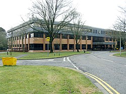
The council inherited offices at West Street in Gorseinon from Llwchwr Urban District Council and at Holly Street in Pontardawe from Pontardawe Rural District Council. It shared its functions between these offices until 1981 when it moved to a purpose-built Civic Centre at Penllergaer. [5] After the council's abolition the former civic centre was used for some years by Swansea Council as secondary offices, before being demolished to make way for a residential development called Mansion Gardens.

Related Research Articles

<span class="mw-page-title-main">Neath Port Talbot</span> County borough in Wales

Neath Port Talbot is a county borough in the south-west of Wales. Its principal towns are Neath, Port Talbot, Briton Ferry and Pontardawe. The county borough borders Bridgend County Borough and Rhondda Cynon Taf to the east, Powys and Carmarthenshire to the north; and Swansea to the west.

<span class="mw-page-title-main">West Glamorgan</span> Preserved county and former administrative county of Wales, United Kingdom

West Glamorgan is a former administrative county in South Wales. It is now a preserved county.

<span class="mw-page-title-main">Gorseinon</span> Human settlement in Wales

Gorseinon is a town within the City and County of Swansea, Wales, near the Loughor estuary. It was a small village until the late 19th century when it grew around the coal mining and tinplate industries. It is situated in the north west of Swansea City Centre, around 6 miles (10 km) north west of the city centre. Gorseinon is a local government community with an elected town council.

<span class="mw-page-title-main">Pontardawe</span> Human settlement in Wales

Pontardawe is a town and a community in the Swansea Valley in Wales. With a population of 6,832 in 2011, it comprises the electoral wards of Pontardawe and Trebanos. A town council is elected. Pontardawe forms part of the county borough of Neath Port Talbot. On the opposite bank of the River Tawe, the village of Alltwen, part of the community of Cilybebyll, is administered separately from Pontardawe. Pontardawe is at the crossroads of the A474 road and the A4067 road. Pontardawe came into existence as a small settlement on the northwestern bank of the Tawe where the drovers' road from Neath and Llandeilo crossed the river to go up the valley to Brecon.

<span class="mw-page-title-main">Gower (UK Parliament constituency)</span> Parliamentary constituency in the United Kingdom, 1885 onwards

<span class="mw-page-title-main">Mawr</span> Human settlement in Wales

Mawr is a community of the City and County of Swansea, in south Wales, U.K. Mawr has its own elected community council. Its name simply means "large", and it was given the name because it was the largest piece of land in the former parish of Llangyfelach.

<span class="mw-page-title-main">District of Neath</span> Former district of West Glamorgan, Wales

Neath was one of the four local government districts of West Glamorgan, Wales from 1974 to 1996.

<span class="mw-page-title-main">District of Port Talbot</span> Former district of West Glamorgan, Wales

Port Talbot was one of the four local government districts of the county of West Glamorgan, Wales from 1974 to 1996. The borough was initially called Afan, changing its name to Port Talbot in 1986.

<span class="mw-page-title-main">Neath Port Talbot County Borough Council</span> Local government of Neath Port Talbot, Wales

Neath Port Talbot County Borough Council is the local authority for the county borough of Neath Port Talbot, one of the 22 principal areas of Wales. The council was controlled by the Labour Party from its creation in 1996 until 2022, when Plaid Cymru and a group of independent councillors agreed to share power.

<span class="mw-page-title-main">City and County of Swansea Council</span> Local government of Swansea

The City and County of Swansea Council, or simply Swansea Council, is the local authority for the city and county of Swansea, one of the principal areas of Wales. The principal area also includes rural areas to the north of the built-up area of Swansea and the Gower Peninsula to the west. The council consists of 75 councillors representing 32 electoral wards.

Llwchwr is a community and electoral ward in the central western part of the City and County of Swansea, Wales, UK. It lies 9 km west-north-west of Swansea city centre and is bounded by the communities of Gorseinon to the north, Penllergaer to the east, and Gowerton to the south, as well as by the estuary of the River Loughor to the west, on the far side of which lies Bynea in Carmarthenshire, connected to Llwchwr by road and rail bridges.

<span class="mw-page-title-main">District of Swansea</span> Former district of West Glamorgan, Wales

The District of Swansea was a local government district with city status in West Glamorgan, Wales from 1974 to 1996.

<span class="mw-page-title-main">Gorseinon (electoral ward)</span> Human settlement in Wales

Gorseinon is the name of an electoral ward in the City and County of Swansea, Wales.

<span class="mw-page-title-main">Pontardawe Arts Centre</span> Multi-purpose cultural venue in Pontardawe, Neath Port Talbot, Wales

Pontardawe Arts Centre is a multi-purpose cultural venue in Pontardawe, Neath Port Talbot, Wales. The building is owned by Neath Port Talbot County Borough Council and is located in Herbert Street.

The history of local government in Wales in a recognisably modern form emerged during the late 19th century. Administrative counties and county boroughs were first established in Wales in 1889. Urban and rural districts were formed in 1894. These were replaced in 1974 by a two-tier authority system across the country comprising eight counties and, within them, thirty-seven districts. This system was itself replaced by the introduction of 22 single-tier authorities in 1996.

Trebanos is an electoral ward of Neath Port Talbot county borough, Wales, part of the Pontardawe community.

The first election to the Neath Port Talbot County Borough Council was held on 4 May 1995. It was followed by the 1999 election. On the same day there were elections to the other 21 local authorities in Wales and community councils in Wales.

<span class="mw-page-title-main">West Glamorgan County Council</span> County council of West Glamorgan

West Glamorgan County Council was the county council of the county of West Glamorgan in south-west Wales, from its creation in 1974 to its abolition in 1996.

The first election to West Glamorgan County Council and was held in April 1973. It was followed by the 1977 election.

References

  1. "Local Government Act 1972", legislation.gov.uk , The National Archives, 1972 c. 70, retrieved 30 October 2022
  2. "The Districts in Wales (Names) Order 1973", legislation.gov.uk , The National Archives, SI 1973/34, retrieved 30 October 2022
  3. "Local Government (Wales) Act 1994", legislation.gov.uk , The National Archives, 1994 c. 19, retrieved 30 October 2022
  4. "Compositions calculator". The Elections Centre. Retrieved 29 October 2022.
  5. "No. 48819". The London Gazette . 11 December 1981. p. 15788.

51°45′43″N3°57′54″W / 51.762°N 3.965°W / 51.762; -3.965