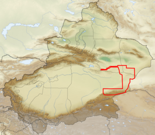
The Lop Desert, or the Lop Depression, is a desert extending from Korla eastwards along the foot of the Kuruk-tagh (meaning Dry Mountain) to the former terminalTarim Basin in the Xinjiang Uyghur Autonomous Region of China. It is an almost perfectly flat expanse with no topographic relief. Lake Bosten in the northwest lies at an altitude of 1,030 to 1,040m (3,380 to 3,410ft), while the Lop Nur in the southeast is only 250 m lower.
The Lop Desert is on the whole flat, but with three slightly more depressed areas which might form lakes if filled with water - the Lop Nor dried basin, Kara-Koshun dried basin and the Taitema Lake basin.[1] These formed, at one time or another, the terminal lakes of the Tarim-Konque-Qarqan river system. The Tarim River changes its course through time, and therefore the location of the terminal lake also changes, causing some confusion amongst the early explorers as to the exact location of Lop Nor, and the lake was thus referred to as the "Wandering Lake."[2]
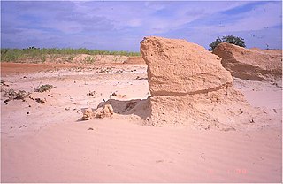
In the past Lop Nur was a huge marsh in the eastern part of Xinjiang. Now the region is a broad, unbroken expanse of clay intermingled with sand. The clay, mostly of a yellow or yellow-grey color, is hard and thickly sprinkled with fine gravel. There are benches, flattened ridges and tabular masses of consolidated clay (yardangs) that are in a distinctly defined laminae, three stories being sometimes superimposed one upon the other, while their vertical faces are abraded, and often undercut, by the wind. The formations themselves are separated by parallel gullies or wind furrows, 6 to 20 feet deep, all sculptured in the direction of the prevailing northeast to southwest wind. There is no drifting sand or sand dunes, except in the south towards the outlying foothills of the Altyn-Tagh.[3]
Satellite picture of the Lop Desert with the basin of the former Lop Nur Sea. The ear-shaped depression is the Lop Nor dried basin.
Climate
The climate of Lop Desert is extremely arid, a study in 1984 gives a mean annual precipitation of generally less than 20mm (0.79in),[1] in another study in 2008 it was recorded as 31.2mm.[4] In the depression centre below 800m (2,600ft) in elevation, aridity can be expected to be much more extreme. Relative humidity of the atmosphere frequently dropped to zero, with air temperature as high as 50°C (122°F). Annual evaporation was estimated in 1984 to be between 1,000 and 1,500mm in 1984, meaning that a lake with about 2 m in water depth will dry out within less than two years if cut off entirely from its feeding source. In 2008 the annual evaporation was reported as 2,901mm.
Historically there were periods when the area was more favorable to farming and settlement than today. Studies showed that the area experienced seven major climate changes since the end of the Pleistocene.[4][5]
There are numerous indications that suggest the presence of an extensive lake in this region which is now completely desiccated. These indications include salt-stained depressions of a lacustrine appearance; traces of former lacustrine shorelines, more or less parallel and concentric; the presence in places of vast quantities of fresh water mollusc shells (species of Lymnaea and Planorbis); the existence of belts of dead poplars; patches of dead tamarisks and extensive beds of withered reeds, all of these are always on top of the yardangs, never in the wind-etched furrows.[3]
In Hanshu (the Book of Han, a history of China completed in 111), where it was called Puchang Hai (蒲昌海), the lake was suggested to be of a great size, with a dimension of 300 to 400 li (roughly 120–160km, 75–100 mi.) in length and breadth.[6] It was also called Yan Ze (鹽澤) in Shiji, which means "salt marsh", indicating that the lake was salty.[7] The lake had already shrunk considerably by the Qing dynasty. It had shifted its location to Kara-Koshun by the latter half of the nineteenth century, then back again to Lop Nor in 1921 through human intervention. The building of dams by Chinese garrisons in the twentieth century blocked the water from the rivers feeding in to Lop Nor and it is now primarily salt flats.[8] The dried-up Lop Nor basin is covered with a salt crust from 0.3 to 1m (0.98 to 3.28ft) thick.
Flora and fauna
Natural vegetation is sparse in the region and poor in the number of species. A scientific expedition to the Lop Nor region in 1979-1982 collected only 36 species of plants, belonging to 13 families (mainly Chenopodiaceae and Compositae) and 26 genera. The expedition also collected only 127 species of animals (23 mammals, 91 birds, 7 reptiles, and 1 amphibian).[1]
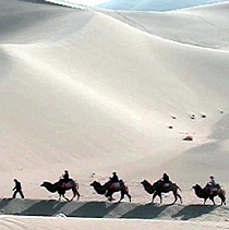
Archaeologist Sven Hedin who travelled in the region in the late nineteenth as well as the twentieth century was able to travel by boat up the rivers to the lake and saw a multitude of wildlife.[8] However, many wild animals, such as tiger, wolf and wild hog which had been found by former explorers, have now disappeared. Nevertheless, it is still the one of the last refuges of wild Bactrian camel (Camelus ferus) in the world. These wild camels may be found in the reed oases on the north edge of the desert. Poplars forests and tamarix shrubs used to be extensively distributed along the lower Tarim River Valley forming the so-called "Green Corridor", but as the lower Tarim River has been drying since 1972 due to the construction of dams, they have greatly deteriorated and some have disappeared. The Lop Nur Wild Camel National Nature Reserve was created in 2001 to preserve wild Bactrian camels and other wildlife in the region.[9]
Sand storms
The whole of this region is swept bare of sand by the terrific sand storms (burans) of the spring months and the particles of wind-blown sand act like a sand blast. Abrasion of the rocks forms yardangs. The desert itself is abraded, filed, eroded and carried bodily away into the network of lakes in which the Tarim River wanders. The sand also blows across the lower, constantly shifting waterways of the Tarim River and deposits itself onto gigantic dunes that choke the eastern end of the Taklamakan Desert.[3] The extreme weather and ever moving sand dunes have resulted in the deaths of hundreds of people. The esteemed biologist Peng Jiamu disappeared in the desert in 1980.[10]
Lop Nur or Lop Nor is a former salt lake, now largely dried up, located in the eastern fringe of the Tarim Basin, between the Taklamakan and Kumtag deserts in the southeastern portion of the Xinjiang. Administratively, the lake is in Lop Nur town, also known as Luozhong of Ruoqiang County, which in its turn is part of the Bayingolin Mongol Autonomous Prefecture.
The Tarim River, known in Sanskrit as the Śītā, is an endorheic river in Xinjiang, China. It is the principal river of the Tarim Basin, a desert region of Central Asia between the Tian Shan and Kunlun Mountains. The river historically terminated at Lop Nur, but today reaches no further than Taitema Lake before drying out.
Karasahr or Karashar, which was originally known in the Tocharian languages as Ārśi, Qarašähär, or Agni or the Chinese derivative Yanqi, is an ancient town on the Silk Road and the capital of Yanqi Hui Autonomous County in the Bayingolin Mongol Autonomous Prefecture, Xinjiang.
A yardang is a streamlined protuberance carved from bedrock or any consolidated or semiconsolidated material by the dual action of wind abrasion by dust and sand and deflation Yardangs become elongated features typically three or more times longer than wide, and when viewed from above, resemble the hull of a boat. Facing the wind is a steep, blunt face that gradually gets lower and narrower toward the lee end. Yardangs are formed by wind erosion, typically of an originally flat surface formed from areas of harder and softer material. The soft material is eroded and removed by the wind, and the harder material remains. The resulting pattern of yardangs is therefore a combination of the original rock distribution, and the fluid mechanics of the air flow and resulting pattern of erosion.
The Desert of Hami is a section of the Gobi Desert in Xinjiang, China that occupies the space between the Tian Shan system on the north and the Nan-shan Mountains on the south, and is connected on the west with the Desert of Lop.
Shanshan was a kingdom located at the north-eastern end of the Taklamakan Desert near the great, but now mostly dry, salt lake known as Lop Nur.
Loulan, also called Krorän or Kroraina, was an ancient kingdom based around an important oasis city along the Silk Road already known in the 2nd century BCE on the northeastern edge of the Lop Desert. The term Loulan is the Chinese transcription of the native name Krorän and is used to refer to the city near Lop Nur as well as the kingdom.
Altyn-Tagh is a mountain range in Northwestern China that separates the Eastern Tarim Basin from the Tibetan Plateau. The western third is in Xinjiang while the eastern part forms the border between Qinghai to the south and Xinjiang and Gansu to the north.
The Tarim Basin deciduous forests and steppe is a temperate broadleaf and mixed forests ecoregion in the Xinjiang Uyghur Autonomous Region of western China. The ecoregion includes deciduous riparian forests and steppes sustained by the region's rivers in an otherwise arid region.
The Turpan water system or Turfan karez system Uyghur: كارىز, romanized: kariz) in Turpan, located in the Turpan Depression, Xinjiang, China, is a vertical tunnel system adapted by the Uyghur people. The word karez means "well" in the local Uyghur language. Turpan has the Turpan Karez Paradise museum dedicated to demonstrating its karez water system, as well as exhibiting other historical artifacts.
The Kumtag Desert, is an arid landform in Northwestern China, which was proclaimed as a national park in the year 2002.
Charklik or Charkhlik is an archeology site named after the town of Charkhlik (Qakilik), in Ruoqiang (Qakilik) County, Xinjiang Uyghur Autonomous Region of the People's Republic of China. Together with the nearby Miran site, they correspond to two ancient capitals of Shanshan, Wuni and Yixun. However, it is as yet unclear which site correspond to which capital.
The Gobi Desert is a large, cold desert and grassland region in northern China and southern Mongolia and is the sixth largest desert in the world. The name of the desert comes from the Mongolian word Gobi, used to refer to all of the waterless regions in the Mongolian Plateau, while in Chinese Gobi is used to refer to rocky, semi-deserts such as the Gobi itself rather than sandy deserts.
The Xiaohe Cemetery, also known as Ördek's Necropolis, is a Bronze Age site located in the west of Lop Nur, in Xinjiang, Western China. It contains about 330 tombs, about 160 of which were looted by grave robbers before archaeological research could be carried out.
Altun Shan National Nature Reserve is a large, arid area in the southeast of Xinjiang Autonomous Region, on the northern edge of the Tibetan plateau and the southern edge of the Tarim Basin in northwest China. It surrounds the Kumkol Basin, an endorheic basin in the western third of the Altyn-Tagh mountains. The reserve is sometimes referred to as the "Arjin Mountains Nature Reserve", or "Aerjinshan". The reserve covers the southern portions of Qiemo County and Ruoqiang County of Bayingolin Mongol Autonomous Prefecture in Xinjiang.
Lop Nur Wild Camel National Nature Reserve protects one of the three remaining habitats of the Wild Bactrian camel, a critically endangered species. The reserve stretches around the north, east, and south of Lop Nur, a dry lake in a desert known as the "Sea of Death", and one of the most arid regions in the world. The reserve was established in 1986 by Xinjiang Province, and has been modified over the years. The reserve is under pressure from new roads in the area, development of mining interests, and illegal hunting.
The Sino-Swedish Expedition was a bilateral Chinese-Swedish expedition, led by Sven Hedin, which carried out scientific research in north and northwest China, 1927–1935.
This page is based on this Wikipedia article Text is available under the CC BY-SA 4.0 license; additional terms may apply. Images, videos and audio are available under their respective licenses.