Gran Desierto de Altar

Last updated
Gran Desierto de Altar
20091211 - Puerto Penasco -63.jpg
Sand dunes at El Pinacate y Gran Desierto de Altar Biosphere Reserve, northwestern Sonora, México
El Pinacate y Gran Desierto de Altar.png
Locator map of the Gran Desierto de Altar,
in Sonora, Mexico
Ecology
Realm Nearctic
Biome Desert
Geography
Area5,700 km2 (2,200 sq mi)
CountryMexico
State Sonora
Climate typeBWh

The Gran Desierto de Altar is one of the major sub-ecoregions of the Sonoran Desert, located in the State of Sonora, in northwest Mexico. It includes the only active erg dune region in North America. The desert extends across much of the northern border of the Gulf of California, spanning more than 100 kilometres (62 mi) east to west and over 50 kilometres (31 mi) north to south. It constitutes the largest continuous wilderness area within the Sonoran Desert.

Contents

The eastern portion of the area contains the volcanic Pinacate Peaks region; together with the western portion, the area forms the El Pinacate y Gran Desierto de Altar Biosphere Reserve and a UNESCO World Heritage Site. [1]

Geography

The Gran Desierto covers approximately 5,700 square kilometres (2,200 sq mi), most of it in the Mexican state of Sonora. The northernmost edges reach across the international border into Organ Pipe Cactus National Monument and Cabeza Prieta National Wildlife Refuge in southwestern Arizona, United States. The region is dominated by sand sheets and dunes ranging in thickness from less than 1 kilometre (0.62 mi) to greater than 12 kilometres (7.5 mi). The total volume of sand in the Gran Desierto is about 60 cubic kilometres (14 cu mi). Most of that volume was delivered by the Colorado River during the Pleistocene, which flowed through the present-day Gran Desierto area approximately 120,000 years before present. This Pleistocene delta migrated westward concomitant with strike-slip faulting and rifting associated with the opening of the Salton Trough and the Gulf of California. [2]

The eastern margin of the Gran Desierto abuts the Cenozoic volcanic complex of the Sierra Pinacate, a composite volcanic field covering more than 1,800 square kilometres (690 sq mi) with a summit elevation of 1,206 metres (3,957 ft). Aeolian sands have climbed onto many of the western slopes of the Sierra Pinacate, defining the eastern limit of the dune field. To the north, the sands thin out against the distal margins of alluvial fans from the Tinajas Altas and Tule Mountains along the Arizona–Sonora border. The southern border of the sand sea is the northern shore of the Gulf of California.

The southernmost extension of the San Andreas Fault cuts across the area and lies beneath several prominent granite inselbergs, most notably the Sierra del Rosario mountains, which are surrounded by the erg on all sides. The Sierra Enterrada is a smaller inselberg almost completely buried by the sand near the boundary of the Gran Desierto and the Pinacate volcanic complex.

Sand dune distribution

The Gran Desierto is best known for its magnificent star dunes, many in excess of 100 metres (330 ft) high. More than two-thirds of the Gran Desierto is covered by sand sheets and sand streaks. The remaining area is split equally between a western population of star dunes and an eastern set of transverse or crescentic dunes. Some of the larger crescentic dunes in the northeastern sand sea exhibit reversing crests, a transitional morphological feature associated with star dunes.

Flora

Vegetation assemblages of the Gran Desierto are typical of the lower Sonoran Desert with a marked difference in vegetation type and density with location. Large areas of the southern and eastern sand sea, especially near the margins, have a moderately dense (up to 20%) cover of perennial low shrubs and herbs such as bursage ( Ambrosia dumosa ) and longleaf jointfir ( Ephedra trifurca ) with creosote bush ( Larrea tridentata ) in areas of thin sand cover. Palo verde/acacia/ocotillo communities occur on alluvial slopes on the northern side of the sand sea, particularly in arroyos and washes. [3] The region's estimated total vegetation cover is 15% in the star dunes and about 10% in the low transverse or crescentic dunes areas. These percentages are substantially greater than in most active dune fields, where vegetation covers of 15% are more typical. [4]

Several teams have examined the middens built by pack rats as a proxy for ancient vegetation regimes. [5] [6] All have concluded that the Gran Desierto has been an ecological refuge for desert plants since at least the late Pleistocene. The Gran Desierto has served as a refuge for most dominant Mojave Desert plant species during cooler pluvial epochs as well. Carbon-14 dating for a midden from the Tinajas Altas Mountains shows assemblages of juniper and Joshua trees coexisting with contemporary Gran Desierto flora and fauna more than 43,000 years before present. [5] Although midden studies do not provide information beyond the late Pleistocene, they do indicate that, in gross form, the climate of the Gran Desierto as recorded by plant communities has been desert-like since at least the peak of the Wisconsinan glaciation.

Fauna

Climate

The Gran Desierto has a warm to hot arid climate. Mean annual rainfall, most of which occurs between September and December, is 73 mm (2.9 in) at Puerto Peñasco, Sonora (located at the southeastern margin of the sand sea on the Gulf of California) and decreases northward toward Yuma, Arizona (on the northwestern edge) to 62 mm (2.4 in) per year. [7] Mid-summer highs in excess of 45 °C (113 °F) are common in the central sand sea. Mid-winter lows of less than 10 °C (50 °F) are rare. Winds are controlled in part by the position and strength of the Sonoran Low in summer, creating southerly winds, and by the Great Basin High in winter, with north-to-northeasterly winds.

Paleoclimate

The well-documented pluvial epochs which occurred over much of the southwestern United States during the most-recent (Wisconsin) ice age may not have extended as far south as the Gran Desierto. [5] [8] It appears that the climatic regime of the past 150,000 years at this site has been one of gradually increasing aridity with current hyper-arid conditions being firmly in place by at least 43,000 years ago. As a minimum, it may be assumed that onshore coastal winds from the south were less important to sand movement when the Wisconsin shoreline was located 45 km (28 mi) seaward of its current position.

Geology

The geological history of the Gran Desierto is intimately linked to the opening of the Gulf of California and the capture of the ancestral Colorado River; source areas that were adjacent to the Gran Desierto have shifted in position, basement topography has been altered continuously, and bedforms have been created, modified, or completely destroyed and then reworked.

The Gran Desierto sand sheets and dunes are located atop deltaic deposits of the Pleistocene Colorado River. The lower Colorado River was captured by the Gulf of California 1.2 million years before present. [9] This event places an upper bound on the age of the Gran Desierto with the Colorado's major clastic sediment sources. Conglomeritic sands and silts beneath the Mesa Arenosa were examined by Colletta and Ortlieb and dated at between 700,000 and 120,000 years before present. [10]

Vertebrate fossils found by Merriam within the deltaic deposits include Equus , Gomphotherium , and Bison and were assigned to Irvingtonian age (0.5 to 1.8 million years before present), dates consistent with the aforementioned capture of the lower Colorado River. [11] Evidence of a giant anteater, Myrmecophaga tridactyla , was found in the deltaic deposits in the southern Gran Desierto. Van Devender notes that the specimen was found in association with fossils of mammoths, sloths, and boa constrictors, a tropical faunal assemblage which supports a contention that the Colorado River delta of a previous interglacial period (>120,000 years ago) was much warmer and wetter than in the present interglacial. [12]

Paleo-deltaic deposits near Salina Grande correlate with a ubiquitous indurated shell deposit dated by Io/U radiometric methods at 146,000 +13,000/-11,000 years of age. [10] Slate (1985) obtained K-Ar ages for basalt flows in the western Pinacates; [13] based on this work, some aeolian activity may have been present as early as 700,000 years ago, as evidenced by the dated accretionary mantles on basalt flows of the Pinacate volcanic field.

Blount and Lancaster proposed that by late Pleistocene time, the Colorado River was a highly competent stream flowing through the area which is occupied today by the massive western star dune zone. [14] The seashore at this time was at least 45 kilometres (28 mi) south of its present-day location. Primary bed loads of poorly sorted gravel were deposited from present-day Yuma, Arizona to an area south of the present-day Sierra del Rosario mountains. As rifting of the Gulf of California progressed to the northwest, and uplift along the coast began, the river channel shifted westward, leaving primary bedload deposits in the former channel and floodplain. Deltaic sediments beneath the Gran Desierto may be as much as 6,000 metres (20,000 ft) deep. [10] [15] [ clarification needed ]

Annual sediment loads prior to the damming of the Colorado River were prodigious. A single flood event deposited an estimated 100,000,000 cubic metres (3.5×10⁹ cu ft) of coarse to medium sand as a sheet deposit on the modern delta just south of the international boundary. [16] Events like this, even if rare, could fill up the Gran Desierto in only a few millennia.

Tectonics

The Gran Desierto is located adjacent to a rapidly subsiding tectonic basin, the Salton Trough, which is a northern extension of the Gulf of California, itself an embayment created by rifting initiated during the Pliocene along the East Pacific Rise and the San Andreas fault system. [17] [18] Regional subsidence has propagated to the northwest as rifting and strike-slip faulting continues into the present day. The central portion of the nearby Salton Trough is more than 70 metres (230 ft) below sea level; it is protected from marine embayment only by the natural dike of the Colorado River Delta.

Ongoing tectonic activity modifies the Gran Desierto today. The southernmost extension of the San Andreas fault system, the Cerro Prieto Fault, passes directly through the area before continuing offshore into the Gulf of California. [19] Strike-slip movement in the area is as high as 60 mm/year. [20] [21]

Since 1900, one magnitude 6.3 and two magnitude 7.1 earthquakes have originated within the erg. Most seismicity within the Gran Desierto originates at depths of 5 to 6 kilometres (3.1 to 3.7 mi), corresponding to the transition between deltaic deposits and basement crystalline rocks. [22] Local uplift is still occurring along the Mesa Arenosa, a drag folded fault block forming the coastal boundary.

Offshore features

The synchronous development of the Colorado River Delta and the associated Gran Desierto sand sink continues offshore into the Gulf of California. Reports on the submarine topography of the Gulf of California by van Andel describe three former river channels on the seafloor: one originating at the present-day Colorado delta, another from the area of the paleo-delta between El Golfo and Salina Grande, and a third to the area of present-day Puerto Peñasco. [23] Rusnak reported on sonar soundings which discovered the valleys and also describe two elongate depressions, each about 40 kilometres (25 mi) in length, into which the valley networks terminate at a depth of approximately 180 metres (590 ft) below sea level. Those incised valley systems were also interpreted as fluvial in origin. [17] [24]

See also

Related Research Articles

<span class="mw-page-title-main">Sonora</span> State of Mexico

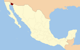
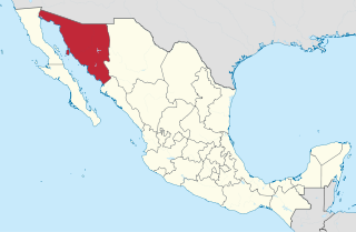
Sonora, officially Estado Libre y Soberano de Sonora, is one of the 31 states which, along with Mexico City, comprise the Federal Entities of Mexico. The state is divided into 72 municipalities; the capital city of which being Hermosillo, located in the center of the state. Other large cities include Ciudad Obregón, Nogales, San Luis Río Colorado, and Navojoa.

<span class="mw-page-title-main">Sonoran Desert</span> Desert in northwestern Mexico and the southwestern United States

The Sonoran Desert is a hot desert in North America and ecoregion that covers the northwestern Mexican states of Sonora, Baja California, and Baja California Sur, as well as part of the southwestern United States. It is the hottest desert in both Mexico and the United States. It has an area of 260,000 square kilometers (100,000 sq mi).

<span class="mw-page-title-main">Yuma Desert</span> Part of the Sonoran Desert

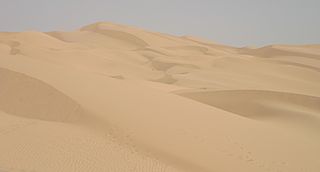
The Yuma Desert is a lower-elevation section of the Sonoran Desert in the southwestern United States and the northwest of Mexico. It lies in the Salton basin. The desert contains areas of sparse vegetation and has notable areas of sand dunes. With an average rainfall less than 8 inches (200 mm) each year, it is among the harshest deserts in North America. Human presence is sparse throughout, the largest city being Yuma, Arizona, on the Colorado River and the border of California.

<span class="mw-page-title-main">Lechuguilla Desert</span> Landform in southwestern Arizona

The Lechuguilla Desert is a small desert located in southwestern Arizona near the U.S.-Mexico border. It is considered to be part of the Lower Colorado Valley region of the Sonoran Desert. It lies in a north–south direction between the Gila Mountains and the Cabeza Prieta Mountains, and almost entirely in the Barry M. Goldwater Air Force Range. The desert is named after the lechuguilla plant, known scientifically as Agave lecheguilla, which occurs exclusively in the Chihuahuan desert many hundreds of miles to the east. The desert is also on the north border of the Gran Desierto de Altar of Sonora, Mexico.

<span class="mw-page-title-main">Algodones Dunes</span> Sand dune field in southeastern California

The Algodones Dunes is a large sand dune field, or erg, located in the southeastern portion of the U.S. state of California, near the border with Arizona and the Mexican state of Baja California. The field is approximately 45 miles (72 km) long by 6 miles (9.7 km) wide and extends along a northwest-southeast line that correlates to the prevailing northerly and westerly wind directions. The name "Algodones Dunes" refers to the entire geographic feature, while the administrative designation for that portion managed by the Bureau of Land Management is the Imperial Sand Dunes Recreation Area. In 1966, Imperial Sand Hills was designated as a National Natural Landmark by the National Park Service. The Algodones Dunes are split into many different sections. These sections include Glamis, Gordon's Well, Buttercup, Midway, and Patton's Valley. Although the Arabic-derived Spanish word algodones translates to "cotton plants", the origin of the toponym is unknown.

<span class="mw-page-title-main">Erg (landform)</span> Broad area of desert covered with wind-swept sand

An erg is a broad, flat area of desert covered with wind-swept sand with little or no vegetative cover. The word is derived from the Arabic word ʿarq (عرق), meaning "dune field". Strictly speaking, an erg is defined as a desert area that contains more than 125 km2 (48 sq mi) of aeolian or wind-blown sand and where sand covers more than 20% of the surface. Smaller areas are known as "dune fields". The largest hot desert in the world, the Sahara, covers 9 million square kilometres and contains several ergs, such as the Chech Erg and the Issaouane Erg in Algeria. Approximately 85% of all the Earth's mobile sand is found in ergs that are greater than 32,000 km2 (12,355 sq mi), the largest being the Rub' al Khali, the Empty Quarter of the Arabian Peninsula. Ergs are also found on other celestial bodies, such as Venus, Mars, and Saturn's moon Titan.

<i>Psorothamnus spinosus</i> Species of legume

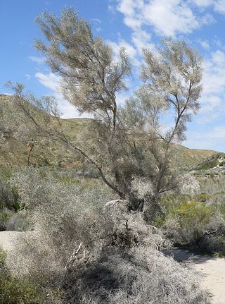
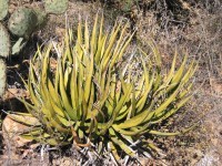
Psorothamnus spinosus, or Delea spinosa, is a perennial legume tree of the deserts in North America. Common names include smokethorn, smoketree, smoke tree, smokethorn dalea, and corona de Cristo.

<i>Condalia globosa</i> Species of tree

Condalia globosa, also called bitter condalia, or bitter snakewood, is a perennial shrub, small tree of the family Rhamnaceae.

<span class="mw-page-title-main">Lower Colorado River Valley</span> Landform in Arizona and California

The Lower Colorado River Valley (LCRV) is the river region of the lower Colorado River of the southwestern United States in North America that rises in the Rocky Mountains and has its outlet at the Colorado River Delta in the northern Gulf of California in northwestern Mexico, between the states of Baja California and Sonora. This north–south stretch of the Colorado River forms the border between the U.S. states of California/Arizona and Nevada/Arizona, and between the Mexican states of Baja California/Sonora.

<span class="mw-page-title-main">Tinajas Altas Mountains</span> Landform in Yuma County, Arizona and Sonora, Mexico

The Tinajas Altas Mountains are an extremely arid northwest–southeast trending mountain range in southern Yuma County, Arizona, approximately 35 mi southeast of Yuma, Arizona. The southern end of the range extends approximately one mile into the northwestern Mexican state of Sonora on the northern perimeter of the Gran Desierto de Altar. The range is about 22 mi in length and about 4 mi wide at its widest point. The highpoint of the range is unnamed and is 2,766 feet above sea level and is located at 32°16'26"N, 114°02'48"W. Aside from the portion of the range in Mexico, the entirety of the range lies within the Barry M. Goldwater Air Force Range. They lie at the heart of the traditional homeland of the Hia C-eḍ O'odham people.

Mohawk is a populated place in Yuma County, Arizona, United States. It is part of the Yuma Metropolitan Statistical Area.

The Sierra Pinta or Sierra Pintas are a narrow remote block faulted northwest-southeast trending mountain range, about 22 miles (35 km) long located in southwestern Arizona in the arid northwestern Sonoran Desert, just north of the Pinacate Reserve of northern Sonora, Mexico. The mountains derive their name from visitor descriptions of its multicolored hues when viewed at sunrise and sunset.

<span class="mw-page-title-main">Pinacate Peaks</span> Group of volcanic mountains and cinder cones in Sonora, Mexico

The Pinacate Peaks are a group of volcanic peaks and cinder cones located mostly in the Mexican state of Sonora along the international border adjacent to the U.S. state of Arizona, surrounded by the vast sand dune field of the Gran Desierto de Altar, at the desert's southeast.

<span class="mw-page-title-main">Coyote Mountains</span> Mountain range in California, United States

The Coyote Mountains are a small mountain range in San Diego and Imperial Counties in southern California. The Coyotes form a narrow ESE trending 2 mi (3.2 km) wide range with a length of about 12 mi (19 km). The southeast end turns and forms a 2 mi (3.2 km) north trending "hook". The highest point is Carrizo Mountain on the northeast end with an elevation of 2,408 feet (734 m). Mine Peak at the northwest end of the range has an elevation of 1,850 ft (560 m). Coyote Wash along I-8 along the southeast margin of the range is 100 to 300 feet in elevation. Plaster City lies in the Yuha Desert about 5.5 mi (8.9 km) east of the east end of the range.

<span class="mw-page-title-main">Puerto Peñasco Municipality</span> Municipality in Sonora, Mexico

Puerto Peñasco Municipality is a municipality in the Mexican state of Sonora in north-western Mexico. As of 2015, the municipality had a total population of 62,177 inhabitants. The only locality with a significant population is the municipal seat, also named Puerto Peñasco, which contains almost 99% of the municipality's population.

<span class="mw-page-title-main">El Pinacate y Gran Desierto de Altar Biosphere Reserve</span> UNESCO biosphere reserve in Sonora, Mexico

El Pinacate and Gran Desierto de Altar Biosphere Reserve is a biosphere reserve and UNESCO World Heritage Site managed by the federal government of Mexico, specifically by Secretariat of the Environment and Natural Resources, in collaboration with the state governments of Sonora and the Tohono O'odham.

<span class="mw-page-title-main">Alto Golfo de California Biosphere Reserve</span> UNESCO biosphere reserve in Sonora, Mexico

Alto Golfo de California Biosphere Reserve is a UNESCO Biosphere Reserve located in the state of Sonora in extreme northwestern Mexico. The 1,652,110 hectares (6,378.8 sq mi) reserve comprises the El Pinacate y Gran Desierto reserve and the Bahia Adair on the Gulf of California border. Geological volcanic formations with craters, dunes, oasis and beaches, and the diversity of plant associations determine its special landscape. The reserve was established in 1993 by the President of Mexico as Reserva de la Biosfera del Alto Golfo de California y Delta del Río Colorado and extended in 1995.

<span class="mw-page-title-main">El Elegante Crater</span> Maar in Sonora, Mexico

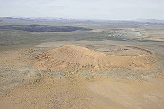
El Elegante is a maar located in the Gran Desierto de Altar in the Sonoran Desert, Mexico.

<span class="mw-page-title-main">Lake Cahuilla</span> Prehistoric lake in the Salton Sea basin of California

Lake Cahuilla was a prehistoric lake in California and northern Mexico. Located in the Coachella and Imperial valleys, it covered surface areas of 5,700 km2 (2,200 sq mi) to a height of 12 m (39 ft) above sea level during the Holocene. During earlier stages of the Pleistocene, the lake reached even higher elevations, up to 31–52 m (102–171 ft) above sea level. During the Holocene most of the water came from the Colorado River with little contribution from local runoff; in the Pleistocene local runoff was higher and it is possible that Lake Cahuilla was supported solely from local water sources during the Wisconsin glaciation. The lake overflowed close to Cerro Prieto into the Rio Hardy, eventually draining into the Gulf of California.

References

  1. UNESCO World Heritage Centre.
  2. Sykes, G., The Colorado Delta, Carnegie Institution/American Geographical Society, New York, 193 p., 1937a.
  3. Felger, R.S., Vegetation and flora of the Gran Desierto, Sonora, Mexico, Desert Plants, 2, 87-114, 1980.
  4. [Seely and Louw, 1980]
  5. 1 2 3 Van Devender, T.R. and Spaulding, W.G., Development of vegetation and climate in the southwestern United States, Science, 204, 701-710, 1979.
  6. Hall, W.E., Van Devender, T.R. and Olson, C.A., Late Quaternary arthropod remains from Sonoran desert packrat middens, southwestern Arizona and northwestern Sonora, Quaternary Research, in press, 1988.
  7. Lancaster, N., Greeley, R. and Christensen, P.R., Dunes of the Gran Desierto sand sea, Sonora, Mexico, Earth Surface Processes and Landforms , 12, 277 -288, 1987.
  8. Spaulding, W.G., Leopold, E.B. and Van Devender, T.R., Late Wisconsin paleoecology of the American Southwest, in, Wright, H.E., Jr., ed., Late Quaternary Environments of the United States, v. 1, Univ. of Minnesota Press, 259–293, 1983.
  9. Lucchitta, I., History of the Grand Canyon and of the Colorado River in Arizona, Az. Geol. Soc., in press, 15 p., 1988.
  10. 1 2 3 Colleta, B. and Ortlieb, L., Deformations of middle and late Pleistocene deltaic deposits at the mouth of the Rio Colorado, northwestern Gulf of California, in Malpica-Cruz, V. et al.(eds.), Neotectonics and sea level variations in the Gulf of California area: A symposium, University Nacional Auton Mexico, Institute Geolocia, 31-53, 1984.
  11. Merriam [1965]
  12. Shaw, C.A. and McDonald, H.G., First record of Giant Anteater (Xenarthra, Myrmecophagidae) in North America, Science, 236, 186-188, 1987.
  13. Slate, J.L., Soil-Carbonate genesis in the Pinacate volcanic field, northwestern Sonora, Mexico, M.S. thesis, University of Arizona, Tucson, 85 p., 1985.
  14. Blount, Grady and Nicholas Lancaster, Development of the Gran Desierto sand sea, northwestern Mexico, Geology, v. 18, pp. 724–728, 1990.
  15. Biehler, S., Kovach, R.L. and Allen, C.R., Geophysical framework of the northern end of the Gulf of California structural province, in Marine Geology of the Gulf of California, van Andel, T .H. and Shor, G.G., eds., A.A.P.G., Memoir 3, 126-143, 1964.
  16. Sykes, G., Delta, estuary, and lower portion of the channel of the Colorado River, 1933 to 1935, Carnegie Institution, New York, 76 p., 1937b.
  17. 1 2 Larson, R.L., Menard, H.W. and Smith, S., Gulf of California: A result of ocean floor spreading and transform faulting, Science, 161, 881-884, 1968.
  18. Angelier, J., Colleta, B., Chorowicz, J., Ortlieb, L. and Rangin, C., Fault tectonics of the Baja California peninsula and the opening of the Sea of Cortez, Mexico, Journal of Structural Geology, 3, 347- 357, 1981.
  19. Merriam, R., San Jacinto fault in northwestern Sonora, Mexico, Bull. G.S.A., 76, 1965.
  20. Curray, J.R. and Moore, D.G., Geologic history of the mouth of the Gulf of California, in, Crouch, J.K. and Bachman, S.B., eds., Tectonics and Sedimentation along the California Margin, Pacific Section-S.E.P.M., 17-36, 1984.
  21. Gastil, R.G., Phillips, R.P. and Allison, E.C., Reconnaissance geology of the state of Baja California, G.S.A. Mem. 140, 170 p., 1975.
  22. Von der Haar, S. and Howard, J.H., Intersecting faults and sandstone stratigraphy at the Cerro Prieto geothermal field, Geothermics, 10, 145-167, 1981.
  23. van Andel, T.H., Recent marine sediments of Gulf of California, in Marine Geology of the Gulf of California, van Andel, T.H. and Shor, G.G., eds., A.A.P .G., Memoir 3, 216-310, 1964.
  24. Ruznak, G.A. and Fisher, R.L., Structural history and evolution of the Gulf of California, in Marine Geology of the Gulf of California, van Andel, T.H. and Shor, G.G., eds., A.A.P .G., Memoir 3, 144-156, 1964.

31°57′N114°08′W / 31.95°N 114.14°W / 31.95; -114.14