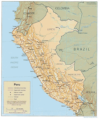
Peru is a country on the central western coast of South America facing the Pacific Ocean. It lies wholly in the Southern Hemisphere, its northernmost extreme reaching to 1.8 minutes of latitude or about 3.3 kilometres (2.1 mi) south of the equator. Peru shares land borders with Ecuador, Colombia, Brazil, Bolivia, and Chile, with its longest land border shared with Brazil.

The geography of Chile is extremely diverse, as the country extends from a latitude of 17° South to Cape Horn at 56° and from the Pacific Ocean in the west to the Andes in the east. Chile is situated in southern South America, bordering the South Pacific Ocean and a small part of the South Atlantic Ocean. Chile's territorial shape is considered among the world's most unusual; from north to south, the country extends 4,270 km (2,653 mi), and yet it only averages 177 km (110 mi) in width. Chile reaches from the middle of South America's west coast straight down to the southern tip of the continent, where it curves slightly eastward. The Diego Ramírez Islands and Cape Horn, the southernmost points in the Americas, where the Pacific and Atlantic oceans meet, are Chilean territory. Chile's northern neighbors are Peru and Bolivia, and its border with Argentina to the east, at 5,150 km (3,200 mi), is the world's third-longest. The total land size is 756,102 km2 (291,933 sq mi). The very long coastline of 6,435 km (3,999 mi) gives Chile the 11th largest exclusive economic zone of 3,648,532 km2 (1,408,706 sq mi).

The Namib is a coastal desert in Southern Africa. According to the broadest definition, the Namib stretches for more than 2,000 kilometres (1,200 mi) along the Atlantic coasts of Angola, Namibia, and northwest South Africa, extending southward from the Carunjamba River in Angola, through Namibia and to the Olifants River in Western Cape, South Africa. The Namib's northernmost portion, which extends 450 kilometres (280 mi) from the Angola-Namibia border, is known as Moçâmedes Desert, while its southern portion approaches the neighboring Kalahari Desert. From the Atlantic coast eastward, the Namib gradually ascends in elevation, reaching up to 200 kilometres (120 mi) inland to the foot of the Great Escarpment. Annual precipitation ranges from 2 millimetres (0.079 in) in the aridest regions to 200 millimetres (7.9 in) at the escarpment, making the Namib the only true desert in southern Africa. Having endured arid or semi-arid conditions for roughly 55–80 million years, the Namib may be the oldest desert in the world and contains some of the world's driest regions, with only western South America's Atacama Desert to challenge it for age and aridity benchmarks.

Piura is a city in northwestern Peru located north of the Sechura Desert on the Piura River. It is the capital of the Piura Region and the Piura Province. Its population was 484,475 as of 2017 and is the 7th most populous city in Peru. The city is located in the central eastern part of the Piura Region, 981 kilometers from the countrys capital, Lima and is near to the border with Ecuador.

La Libertad is a department and region in northwestern Peru. Formerly it was known as the Department of La Libertad. It is bordered by the Lambayeque, Cajamarca and Amazonas regions on the north, the San Martín Region on the east, the Ancash and Huánuco regions on the south and the Pacific Ocean on the west. Its capital is Trujillo, which is the nation's third biggest city. The region's main port is Salaverry, one of Peru's largest ports. The name of the region is Spanish for "freedom" or "liberty"; it was named in honor of the Intendancy of Trujillo's proclaiming independence from Spain in 1820 and fighting for that. It is the ninth smallest department in Peru, but it is also its second-most populous department after Piura and its second-most densely populated department after Lambayeque.
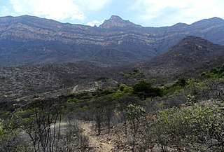
Lambayeque is a department and region in northwestern Peru known for its rich Moche and Chimú historical past. The region's name originates from the ancient pre-Inca civilization of the Lambayeque. It is the second-smallest department in Peru after Tumbes, but it is also its most densely populated department and its eighth most populous department.
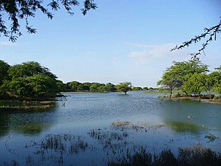
Piura is a coastal department and region in northwestern Peru. The region's capital is Piura and its largest port cities, Paita and Talara, are also among the most important in Peru. The area is known for its tropical and dry beaches. It is the most populous department in Peru, its twelfth smallest department, and its fourth-most densely populated department, after Tumbes, La Libertad, and Lambayeque.

Illescas is a peninsula in northwestern Peru. It forms the southern boundary of the Sechura Bay, the largest bay in Peru. Sechura Bay also includes the northernmost portion of the Pacific Ocean that is under the influence of the Peru-Chile or Humboldt Current. The Illescas Peninsula is located in the department of Piura, and is scarcely inhabited. Part of Illescas was declared a reserved zone. Illescas is also the name given to the highest point of the peninsula, the Cerro Illescas.

Climate of Peru describes the diverse climates of this large South American country with an area of 1,285,216 km2 (496,225 sq mi). Peru is located entirely in the tropics but features desert and mountain climates as well as tropical rainforests. Elevations above sea level in the country range from −37 to 6,778 m and precipitation ranges from less than 20 mm (0.79 in) annually to more than 8,000 mm (310 in). There are three main climatic regions: the Pacific Ocean coast is one of the driest deserts in the world but with some unique features; the high Andes mountains have a variety of microclimates depending on elevation and exposure and with temperatures and precipitation from temperate to polar and wet to dry; and the Amazon basin has tropical climates, mostly with abundant precipitation, along with sub-tropical climates in elevations above 1,550 m (5,090 ft).

The Norte Grande is one of the five natural regions into which CORFO divided continental Chile in 1950. It borders Peru to the north, the Pacific Ocean to the west, the Altiplano, Bolivia and Argentina to the east, and the Copiapó River to the south, beyond which lies the Norte Chico natural region.

A fog desert is a type of desert where fog drip supplies the majority of moisture needed by animal and plant life. Examples of fog deserts include the Atacama Desert of coastal Chile and Peru; the Baja California desert of Mexico; the Namib Desert in Namibia; the Arabian Peninsula coastal fog desert; and a manmade instance within Biosphere 2, an artificial closed ecosphere in Arizona.
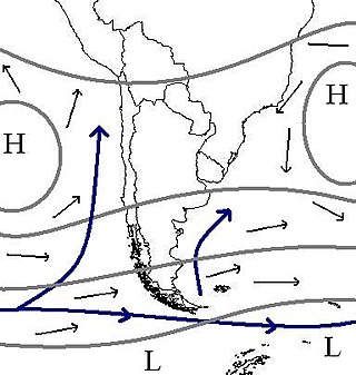
The South Pacific High is a semi-permanent subtropical anticyclone located in the southeast Pacific Ocean. The area of high atmospheric pressure and the presence of the Humboldt Current in the underlying ocean make the west coast of Peru and northern Chile extremely arid. The Sechura and Atacama deserts, as the whole climate of Chile, are heavily influenced by this semi-permanent high-pressure area. This high-pressure system plays a major role in the El Niño–Southern Oscillation (ENSO), and it is also a major source of trade winds across the equatorial Pacific.

The Atacama Desert is a desert plateau located on the Pacific coast of South America, in the north of Chile. Stretching over a 1,600 km (990 mi) strip of land west of the Andes Mountains, it covers an area of 105,000 km2 (41,000 sq mi), which increases to 128,000 km2 (49,000 sq mi) if the barren lower slopes of the Andes are included.
Motupe River is a river of Lambayeque Region in northwestern Peru. The Motupe River Basin, which includes its major tributary the La Leche River, is bounded by the Chancay-Lambayeque River Basin to the south, by the Olmos River Basin to the north, by the river basins of the Chotano and Huancabamba to the east, and on the west by the Pacific Ocean. The river receives its name from the village of Motupe, nearby where the Motupe River is formed.

Lomas, also called fog oases and mist oases, are areas of fog-watered vegetation in the coastal desert of Peru and northern Chile. About 100 lomas near the Pacific Ocean are identified between 5°S and 30°S latitude, a north–south distance of about 2,800 kilometres (1,700 mi). Lomas range in size from a small vegetated area to more than 40,000 hectares and their flora includes many endemic species. Apart from river valleys and the lomas the coastal desert is almost without vegetation. Scholars have described individual lomas as "an island of vegetation in a virtual ocean of desert."

From December 2016 and continuing until May 2017, much of western and central South America was plagued by persistent heavy rain events. In Peru, one of the most severely impacted nations, it has been referred to as the 2017 Coastal Niño. The flooding was preceded by drought-like conditions throughout the region for much of 2016 and a strong warming of sea temperatures off the coast of Peru.

The Tumbes–Piura dry forests (NT0232) is an arid tropical ecoregion along the Pacific coasts of southern Ecuador and northern Peru. The ecoregion contains many endemic species of flora and birds adapted to the short wet season followed by a long dry season. Threats include extraction of wood for fuel or furniture, and capture of wild birds for sale.

The Piura River is a river in northern Peru. The river flows westward from the Andes to the Pacific Ocean and is susceptible to major flooding. Piura is the largest city along the river's course.

Zaña or Saña is the capital of Zaña District in the Chiclayo Province of Lambayeque region in northern Peru. It is located 25 kilometres (16 mi) inland from the Pacific Ocean at an elevation of 58 metres (190 ft) in the valley of the Zaña River. Zaña had a population of 4,510 in 2017. The town was founded in 1563 by the Spanish conquerors of Peru. The Zaña Valley became a major area of sugar cane production and Zaña was one of the most important cities of colonial Peru. The wealth of Zaña attracted English pirates who raided the city in 1686. A flood destroyed Zaña in 1720 and it never recovered its previous importance. Ruins from the flood still exist at the edge of the 21st century town.
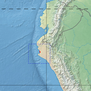
The Piura mangroves ecoregion covers a very small mangrove site on the Piura River Delta, on the Pacific Ocean in northwestern Peru. This small mangrove site is at the northern tip of the Sechura Desert. The climate is normally semi-arid, but cn be much wetter in El Nino years. The area is a RAMSAR wetland of international importance "Manglares de San Pedro de Vice", and is an important stopover for migratory birds.


