Los Angeles's 8th City Council district

Last updated

Los Angeles's 8th
City Council district
Flag of Los Angeles, California.svg
Los Angeles City Council District 8.svg
Councilmember
  Marqueece Harris-Dawson
D Gramercy Park
Demographics2.0%  White
41.7%  Black
55.2%  Hispanic
2.1%  Asian
Population (2020)259,409
Registered voters (2017)136,657
Website councildistrict8.lacity.gov

Los Angeles's 8th City Council district is one of the fifteen districts in the Los Angeles City Council. It is currently represented by Democrat Marqueece Harris-Dawson since 2015 after winning an election to succeed Bernard C. Parks, who termed out.

Contents

The district was created in 1925 after a new city charter was passed, which replaced the former "at large" voting system for a nine-member council with a district system with a 15-member council. As the city's population expanded to the west, the 8th District's boundaries gradually shifted that way as well.

Geography

The 8th District includes the neighborhoods of Baldwin Hills, Chesterfield Square, Crenshaw, Jefferson Park, and other communities of western South Los Angeles. [1]

The district overlaps California's 37th and 43rd congressional districts, California's 28th and 35th State Senate districts, as well as California's 55th, 57th, and 61st State Assembly districts.

Historical boundaries

The district was preceded by the eighth ward, established in 1889 with the passing of the 1888 charter. It included Westlake and Downtown. It elected one member through a plurality vote before the ward became obsolete when the at-large district was re-established again in 1909. [2] The ward had one of the longest serving members before the passing of the 1925 charter, being Republican Everett L. Blanchard who served for fifteen years.

In 1925, the district was created, with the borders of the district at south of Washington Street, north of Jefferson on the western side and north of Slauson Avenue on the eastern side, bounded on the east by Alameda Street and the Vernon city line. [3] A year later, it was bounded by 47th Street, Vermont Avenue, Florence Avenue and Alameda Street. [4] [5] In 1933, due to the "exceptional growth of the western part of the city," the new boundaries were at Central Avenue, Vernon Avenue, Vermont Avenue, and Century Boulevard. [6] [7]

In 1940, the "general trend [was] westward and northeastward, due to heavy construction in the San Fernando Valley and the beach areas." It was bounded on the north by Vernon Avenue, on the west by Western Avenue, on the east by the city limits or Alameda Street and on the south by about Slauson Avenue. [8] In 1955, it bordered on Huntington Park and Vernon, from Vernon Avenue to 94th Street." By this time, a sizable amount of the total population in the district was African American, and their influence would later help Billy G. Mills, one of the first three African Americans to be elected to the City Council, in 1963. [9] In 1964, it was enlarged by absorbing two-thirds of the old 12th District, which was moved to the San Fernando Valley because of the growth of population there. [10]

By 1971, it ran from Adams Boulevard through the south central city to around Century Boulevard, including parts of Watts. [11] By 1975, the district ran in a north-south line in South Los Angeles. It was described as suffering from "some of the worst crime, unemployment and housing problems in the city." [12] In 1992, the district boundaries had shifted west to include Marlton Square on Crenshaw Boulevard. [13] as well as Baldwin Hills. [14]

List of members representing the district

1889–1909

CouncilmemberPartyYearsElectoral history
Single-member ward established February 25, 1889
Theodore Summerfield, Los Angeles County assessor, 1905.png
Theodore Summerland
(Downtown)
Republican February 25, 1889 –
December 12, 1892
Elected in 1889.
Re-elected in 1890.
[ data missing ]
John T. Gaffey, 1905.png
John T. Gaffey
(Downtown)
Democratic December 12, 1892 –
March 5, 1894
Elected in 1892.
Resigned.
Hugh J. Smith, 1894.png
Hugh J. Smith
(Downtown)
Democratic April 23, 1894 –
December 12, 1894
Appointed to finish Gaffey's term.
[ data missing ]
Thomas Savage, 1904.png
Thomas F. Savage
(Downtown)
Democratic December 12, 1894 –
December 16, 1896
Elected in 1894.
[ data missing ]
Edward L. Hutchinson, 1903.png
Edward L. Hutchinson
(Westlake)
Populist December 16, 1896 –
December 15, 1898
Elected in 1898.
[ data missing ]
Robert Asa Todd, 1898.jpg
Robert A. Todd
(Westlake)
Democratic December 15, 1898 –
December 8, 1904
Elected in 1898.
Re-elected in 1900.
Re-elected in 1902.
[ data missing ]
Bernard Healy, 1906.png
Bernard Healy
(Sonoratown)
Republican December 8, 1904 –
December 10, 1909
Elected in 1904.
Re-elected in 1906.
Redistricted to the at-large district and lost re-election.
Single-member ward eliminated December 10, 1909

1925–present

CouncilmemberPartyDatesElectoral history
District established July 1, 1925
Frank L. Shaw, 1927.jpg
Frank L. Shaw
(Florence)
Republican July 1, 1925 –
November 28, 1928
Elected in 1925.
Resigned when elected to the L.A. County Board of Supervisors.
VacantNovember 28, 1928 –
December 3, 1928
Evan Lewis, 1935.jpg
Evan Lewis
(South Park)
Republican December 3, 1928 –
May 5, 1941
Appointed to finish Shaw's term.
Elected in 1933.
Re-elected in 1937.
Re-elected in 1939.
Announced retirement, then died.
VacantMay 5, 1941 –
July 1, 1941
Charles A. Allen, 1943.jpg
Charles A. Allen
(Vermont Knolls)
Republican July 1, 1941 –
June 30, 1947
Elected in 1941.
Re-elected in 1943.
Re-elected in 1945.
Lost re-election.
Kenneth Hahn, 1948.jpg
Kenneth Hahn
(South Park)
Democratic July 1, 1947 –
June 15, 1953
Elected in 1947.
Re-elected in 1949.
Re-elected in 1951.
Resigned when elected to the L.A. County Board of Supervisors.
Gordon Hahn, 1958.jpg
Gordon Hahn
(South Park)
Republican June 15, 1953 –
June 30, 1963
Appointed to finish his brother's term.
Elected in 1953.
Re-elected in 1955.
Re-elected in 1959.
Retired.
Billy G. Mills, 1963.jpg
Billy G. Mills
(Jefferson Park)
Democratic July 1, 1963 –
April 11, 1974
Elected in 1963.
Re-elected in 1967.
Re-elected in 1971.
Resigned when appointed to
the Superior Court of California.
VacantApril 11, 1974 –
June 28, 1974
Robert C. Farrell, 1978.jpg
Robert C. Farrell
(Manchester Square)
Democratic June 28, 1974 –
June 30, 1991
Elected to finish Mills's term.
Re-elected in 1975.
Re-elected in 1979.
Re-elected in 1983.
Re-elected in 1987.
Retired.
Mark Ridley-Thomas, 1984.jpg
Mark Ridley-Thomas
(Leimert Park)
Democratic July 1, 1991 –
November 29, 2002
Elected in 1991.
Re-elected in 1995.
Re-elected in 1999.
Resigned when elected
to the California State Assembly.
VacantNovember 29, 2002 –
July 1, 2003
Bernard C. Parks 2010 (1).jpg
Bernard C. Parks
(Crenshaw)
Democratic July 1, 2003 –
June 30, 2015
Elected in 2003.
Re-elected in 2007.
Re-elected in 2011.
Termed out.
Marqueece Harris-Dawson, 2018.jpg
Marqueece Harris-Dawson
(Gramercy Park)
Democratic July 1, 2015 –
present
Elected in 2015.
Re-elected in 2020.

Related Research Articles

<span class="mw-page-title-main">Leimert Park, Los Angeles</span> Neighborhood of Los Angeles in California, United States

Leimert Park is a neighborhood in the South Los Angeles region of Los Angeles, California.

<span class="mw-page-title-main">West Adams, Los Angeles</span> Neighborhood of Los Angeles in California, United States

West Adams is a historic neighborhood in the South Los Angeles region of Los Angeles, California. The area is known for its large number of historic buildings, structures and notable houses and mansions. It contains several Historic Preservation Overlay Zones as well as designated historic districts.

<span class="mw-page-title-main">Crenshaw, Los Angeles</span> Neighborhoods of Los Angeles in California, United States

Crenshaw, or the Crenshaw District, is a neighborhood in South Los Angeles, California.

<span class="mw-page-title-main">Crenshaw Boulevard</span> Major street in Los Angeles

Crenshaw Boulevard is a north-south thoroughfare in Los Angeles, California, United States, that runs through Crenshaw and other neighborhoods along a 23-mile route in the west-central part of the city.

<span class="mw-page-title-main">South Park, Los Angeles</span> Neighborhood of Los Angeles in California, United States

South Park is a 1.41 square miles (3.65 km2) neighborhood within the South Los Angeles region of Los Angeles, California.

<span class="mw-page-title-main">Slauson Avenue</span> Thoroughfare in Los Angeles County, California, US

Slauson Avenue is a major east–west thoroughfare traversing the central part of Los Angeles County, California. It was named for the land developer and Los Angeles Board of Education member J. S. Slauson. It passes through Culver City, Ladera Heights, View Park-Windsor Hills, South Los Angeles, Huntington Park, Maywood, Commerce, Montebello, Pico Rivera, Whittier, and Santa Fe Springs. The street runs 20.9 miles (33.6 km) from McDonald Street in Culver City and to Santa Fe Springs Road, where it becomes Mulberry Drive in Whittier. Mulberry Drive ends at Scott Avenue in South Whittier.

<span class="mw-page-title-main">Hyde Park, Los Angeles</span> Neighborhood of Los Angeles in California, United States

Hyde Park is a neighborhood in the South region of Los Angeles, California. Formerly a separate city, it was consolidated with Los Angeles in 1923.

This article covers streets in Los Angeles, California between and including 41st Street and 250th Street. Major streets have their own linked articles; minor streets are discussed here.

<span class="mw-page-title-main">South Los Angeles</span> Region of Los Angeles County in California, United States

South Los Angeles, also known as South Central Los Angeles or simply South Central, is a region in southwestern Los Angeles County, California, lying mostly within the city limits of Los Angeles, south of downtown. It is "defined on Los Angeles city maps as a 16-square-mile rectangle with two prongs at the south end.” In 2003, the Los Angeles City Council renamed this area "South Los Angeles".

<span class="mw-page-title-main">Los Angeles's 15th City Council district</span> American legislative district

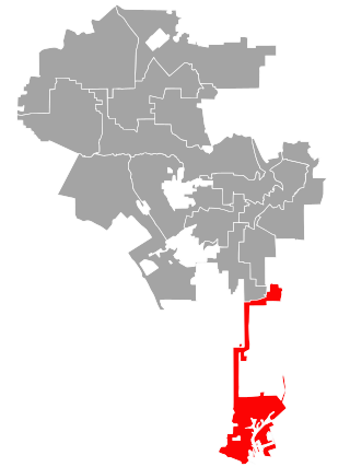
Los Angeles's 15th City Council district is one of the fifteen districts in the Los Angeles City Council. It is currently represented by Democrat Tim McOsker since 2022, after previous member Joe Buscaino retired to run for mayor that year.

<span class="mw-page-title-main">Los Angeles's 9th City Council district</span> American legislative district

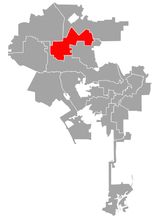
Los Angeles's 9th City Council district is one of the fifteen districts in the Los Angeles City Council. It is currently represented by Democrat Curren Price since 2013 after winning an election to succeed Jan Perry, who ran for Mayor of Los Angeles that year.

<span class="mw-page-title-main">Los Angeles's 2nd City Council district</span> American legislative district

Los Angeles's 2nd City Council district is one of the fifteen districts in the Los Angeles City Council. It is currently represented by Democrat Paul Krekorian since 2009, after he won the special election to finish Wendy Greuel's term.

<span class="mw-page-title-main">Los Angeles's 4th City Council district</span> American legislative district

Los Angeles's 4th City Council district is one of the fifteen districts in the Los Angeles City Council. It is currently represented by Democrat Nithya Raman since 2020 after she defeated David Ryu in that year's election. The district is situated in Central Los Angeles, the southern San Fernando Valley, and eastern Santa Monica Mountains.

<span class="mw-page-title-main">Los Angeles's 5th City Council district</span> American legislative district

Los Angeles's 5th City Council district is one of the fifteen districts in the Los Angeles City Council. It is currently represented by Democrat Katy Young Yaroslavsky since 2022 after winning an election to succeed Paul Koretz, who termed out.

<span class="mw-page-title-main">Los Angeles's 6th City Council district</span> American legislative district

Los Angeles's 6th City Council district is one of the fifteen districts in the Los Angeles City Council. It is currently represented by Imelda Padilla.

<span class="mw-page-title-main">Los Angeles's 7th City Council district</span> American legislative district

Los Angeles's 7th City Council district is one of the fifteen districts in the Los Angeles City Council. It is currently represented by Democrat Monica Rodriguez since 2017 after winning an election to succeed Felipe Fuentes, who resigned the year prior.

<span class="mw-page-title-main">Los Angeles's 10th City Council district</span> American legislative district

Los Angeles's 10th City Council district is one of the fifteen districts in the Los Angeles City Council. It is currently represented by Democrat Heather Hutt since 2022, after previous member Herb Wesson was barred from serving on an interim basis in place of suspended member Mark Ridley-Thomas.

<span class="mw-page-title-main">Central-Alameda, Los Angeles</span> Neighborhood of Los Angeles in California, United States

Central-Alameda is a 2.18 square miles (5.65 km2) square mile neighborhood within the South Los Angeles region of Los Angeles, California.

<span class="mw-page-title-main">Crenshaw Manor, Los Angeles</span> Neighborhood of Los Angeles in California, United States

Crenshaw Manor is a neighborhood in Los Angeles, California.

References

  1. Hernández, Caitlin (November 18, 2022). "LA City Council In 2023: Your Guide To Who's Who (And What They Do)". LAist .
  2. Stevens, Mark H. The Road to Reform: Los Angeles' Municipal Elections of 1909: Part II. Vol. 86. University of California Press. pp. 325–368.
  3. "Map Showing City's Council Districts," Los Angeles Times, January 16, 1925, page A-1
  4. "To the Citizens of Los Angeles," Los Angeles Times, February 14, 1926, page B-5
  5. "Council Areas' Lines Changed," Los Angeles Times, December 29, 1928, page A-1
  6. "District Lines Approved," Los Angeles Times, December 24, 1932, page A-1
  7. "City Reapportionment Measure Gets Approval," Los Angeles Times, January 19, 1933 With map of all districts.
  8. "Proposed New Alignment for City Voting Precincts," Los Angeles Times, November 30, 1940, page A-3 Includes a map.
  9. "Unusual Setup for Council's Contests," Los Angeles Times, April 3, 1955, page B-2
  10. "New Council Districting Voted 14-0," Los Angeles Times, July 16, 1964, page A-1
  11. Bill Boyarsky, "Yorty-Potter Clash Seen as Filings Close," Los Angeles Times, January 12, 1971, page A-1
  12. Doug Shuit, "5 Council Incumbents Coasting," Los Angeles Times, March 23, 1975, page E-2
  13. James Rainey and Greg Krikorian, "Beaten to the Draw, Holden Vows a Fight," Los Angeles Times, October 4, 1992, page 1
  14. "Crenshaw Ridley-Thomas Field Office," Los Angeles Times, July 30, 1992