
Wilkes-Barre is a city in and the county seat of Luzerne County, Pennsylvania, United States. Located at the center of the Wyoming Valley in Northeastern Pennsylvania, it had a population of 44,328 in the 2020 census. It is the second-largest city, after Scranton, in the Scranton–Wilkes-Barre–Hazleton, PA Metropolitan Statistical Area, which had a population of 567,559 as of the 2020 census, making it the fifth-largest metropolitan area in Pennsylvania after the Delaware Valley, Greater Pittsburgh, the Lehigh Valley, and Greater Harrisburg.

Luzerne County is a county in the Commonwealth of Pennsylvania. According to the United States Census Bureau, the county has a total area of 906 square miles (2,350 km2), of which 890 square miles (2,300 km2) is land and 16 square miles (41 km2) is water. It is Northeastern Pennsylvania's second-largest county by total area. As of the 2020 census, the population was 325,594, making it the most populous county in the northeastern part of the state. The county seat and most populous city is Wilkes-Barre. Other populous communities include Hazleton, Kingston, Nanticoke, and Pittston. Luzerne County is included in the Scranton–Wilkes-Barre–Hazleton Metropolitan Statistical Area, which has a total population of 555,426 as of 2017. The county is part of the Northeastern Pennsylvania region of the state.

Plains Township is a township in Luzerne County, Pennsylvania, United States. The population was 9,816 at the 2020 census. The municipality is the birthplace of Chicago White Sox hall of famer Ed Walsh and John J. Yeosock, a United States Army general who commanded the 3rd U.S. Army during Operation Desert Shield and Operation Desert Storm. Mohegan Pennsylvania is a casino in Plains Township.

White Haven is a borough in Luzerne County, Pennsylvania, United States. It is located along the Lehigh River. The population was 1,163 at the 2020 census.

Wyoming is a borough in the Greater Pittston area of Luzerne County, Pennsylvania, United States. It is located 5 miles (8 km) north of Wilkes-Barre, along the Susquehanna River. The population was 3,097 as of the 2020 census.

Wilkes-Barre Township is a township with home rule status in Luzerne County, Pennsylvania, United States. It is adjacent to the city of Wilkes-Barre. The population of the township was 3,219 at the 2020 census.

The Wyoming Valley is a historic industrialized region of Northeastern Pennsylvania. The region is historically notable for its influence in helping fuel the American Industrial Revolution with its many anthracite coal-mines. As a metropolitan area, it is known as the Scranton/Wilkes-Barre metropolitan area, after its principal cities, Scranton and Wilkes-Barre. With a population of 567,559 as of the 2020 United States census, it is the fifth-largest metropolitan area in Pennsylvania, after the Delaware Valley, Greater Pittsburgh, the Lehigh Valley, and the Harrisburg–Carlisle metropolitan statistical areas.
Northeastern Pennsylvania is a region of the U.S. state of Pennsylvania that includes the Pocono Mountains, the Endless Mountains, and the industrial cities of Scranton, Wilkes-Barre, Pittston, Hazleton, Nanticoke, and Carbondale. A portion of this region is located in the New York City metropolitan area. Recently, Pennsylvania tourism boards have described Northeastern Pennsylvania as Upstate Pennsylvania.
Jesse Fell was an early political leader in Wilkes-Barre, Pennsylvania. He was one of the first Pennsylvanians to successfully burn anthracite on an open air grate. Anthracite differs from wood in that it needs a draft from the bottom, and Judge Fell proved with his grate design that it was a viable heating fuel. His method and 'discovery' in 1808 led to the widespread use of coal as the fuel source that helped to foster America's industrial revolution. He lived in the Fell House and Tavern until his death. The House stood until the 1980s when Wyoming Valley Health Care demolished it to build a parking lot. The bricks used to build the house are now in the house of Wayne Segar in Bear Creek Pennsylvania. The grate used by Fell is in the possession of the Wyoming Historical and Geological Society.
Regions of Pennsylvania in the United States include:

Greater Pittston is a 65.35 sq mi (169.3 km2) region in Luzerne County, Pennsylvania, in reference to the area in and around Pittston. As of 2010, the total population of Greater Pittston is 48,020. This region includes Avoca, Dupont, Duryea, Exeter Boro, Exeter Township, Hughestown, Jenkins Township, Laflin, Pittston Township, West Pittston, West Wyoming, Wyoming, and Yatesville. It is a subregion of Wyoming Valley.
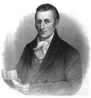
Charles Miner was an anti-slavery advocate and politician who served in the Pennsylvania State House of Representatives from 1807 to 1808 and the United States House of Representatives from 1825 to 1829. He was a member of the Federalist Party. During his terms in Congress, he proposed to end the slave trade in the District of Columbia and gradually abolish slavery across the city.

The Swetland Homestead is an historic, American home that is located in Wyoming, Luzerne County, Pennsylvania.
Thomas Henry Atherton Jr., was an American architect and decorated World War I officer. He designed many public buildings in New York and Pennsylvania and a war memorial in France. A number of his works, including numerous National Guard armories in eastern Pennsylvania, are listed on the U.S. National Register of Historic Places.
The Wyoming Division Canal was an anthracite canal in Luzerne County, Pennsylvania, in the United States. It was a branch of the North Branch Canal, which was one of only two major canals in Pennsylvania to be owned by the state. The creek went from West Nanticoke to Pittston, going through Luzerne County.

Solomon Creek is a tributary of the Susquehanna River in Luzerne County, Pennsylvania, in the United States. It is approximately 8.8 miles (14.2 km) long and flows through Fairview Township, Hanover Township, and Wilkes-Barre. The creek is affected by acid mine drainage and has significant loads of iron, aluminum, and manganese. The creek's named tributaries are Spring Run, Sugar Notch Run, and Pine Creek. The Solomon Creek watershed is located in the Anthracite Valley section of the ridge-and-valley geographical province. Major rock formations in the watershed include the Mauch Chunk Formation, the Spechty Kopf Formation, and the Catskill Formation.

There are two types of coal found in Pennsylvania: anthracite, the hard coal found in Northeastern Pennsylvania below the Allegheny Ridge southwest to Harrisburg, and bituminous, the soft coal found west of the Allegheny Front escarpment). Anthracite coal is a natural mineral with a high carbon and energy content that gives off light and heat produced energy when burned, making it useful as a fuel. It was possibly first used in Pennsylvania as a fuel in 1769, but its history begins with a documented discovery near Summit Hill and the founding of the Lehigh Coal Mine Company in 1792 to periodically send expeditions to the wilderness atop Pisgah Ridge to mine the deposits, mostly with notable lack of great success, over the next 22 years.

Coal Creek is a tributary of the Susquehanna River in Luzerne County, Pennsylvania, in the United States. It is approximately 2.9 miles (4.7 km) long and flows through Plymouth Township and Plymouth. The watershed of the creek has an area of 1.46 square miles (3.8 km2). A reservoir known as Spring Brook Reservoir Number Four is situated on the creek. The surficial geology near the creek includes Wisconsinan Till, Wisconsinan Ice-Contact Stratified Drift, alluvium, coal dumps, and bedrock consisting of sandstone and shale. On July 3, 2011, Coal Creek flooded when 5 inches (13 cm) of rain fell in the watershed in less than 90 minutes. The flood caused $5 million in damage. The creek is designated as a Coldwater Fishery and a Migratory Fishery.
Plymouth, Pennsylvania sits on the west side of Pennsylvania's Wyoming Valley, wedged between the Susquehanna River and the Shawnee Mountain range. Just below the mountain are hills that surround the town and form a natural amphitheater that separates the town from the rest of the valley. Below the hills, the flat lands are formed in the shape of a frying pan, the pan being the Shawnee flats, once the center of the town's agricultural activities, and the handle being a spit of narrow land extending east from the flats, where the center of town is located. At the beginning of the 19th century, Plymouth's primary industry was agriculture. However, vast anthracite coal beds lay below the surface at various depths, and by the 1850s, coal mining had become the town's primary occupation.

The Luzerne County Library System (LCLS) is an organization that administers ten libraries in Luzerne County, Pennsylvania. Founded in 1984, it is headquartered at the Osterhout Free Library in Wilkes-Barre, Pennsylvania. Along with hosting various permanent and temporary collections of books and media, the member libraries provide various services and activities.