
Bahraich district is one of the districts of Uttar Pradesh state of India, and Bahraich town is the district headquarters. Bahraich District is a part of Devipatan Division.
Maharajganj district is one of the 75 districts of Uttar Pradesh state in northern India, and the town of Maharajganj is the district headquarters. District is a part Gorakhpur division. It is located in Terai region of Himalayas, bordering Nepal in North. Gandak, Rapti, Rohin are some major river flowing through the district.

Lakhimpur Kheri district is the largest district in Uttar Pradesh, India, on the border with Nepal. Its administrative capital is the city of Lakhimpur.
Gorakhpur district is one of the 75 districts of Uttar Pradesh state in northern India. This district is a part of the Gorakhpur division. The city of Gorakhpur, or Gorakhpur is the administrative headquarters of this district and Gorakhpur division. It borders Sant Kabir Nagar district to the west, Kushinagar and Deoria districts to the east, and Maharajganj and Azamgarh districts to the north and south.
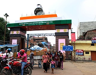
Nautanwa is a town and Nagar Palika in Maharajganj district in the state of Uttar Pradesh, India. It is about 87 km from Gorakhpur, NH24 and 68 km NH730 from Maharajganj and 7 km from Sonauli Indo-Nepal Border.
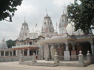
Pharenda, or Anandnagar, is a city in the Maharajganj district of the province of Uttar Pradesh in northern India. It is located approximately 44 kilometres north of Gorakhpur near the border with Nepal. District of Pharenda is Maharajganj. This is situated on the Buddhist Circuit which is built from Sarnath to Lumbini. It lies on NH-24 and near NH 29. It is about 45 km from Gorakhpur, 40 km from Siddharthnagar, 30 km from Maharajganj and 55 km from Sonauli Indo-Nepal border. This place is named after Seth Anandram Jaypuriya. There is closed sugar Mill which was started in about 1935 and closed in 1995. Near Anand Nagar there is a temple is Durga devi mandir, popularly known as Lehara Devi mandir.
Maharajganj is a town and a nagar panchayat in Azamgarh district in the Indian state of Uttar Pradesh. It is connected to National Highway 233B (India), linking Azamgarh to Rajesultanpur.
Phulpur is a town and a nagar panchayat in Azamgarh district in the Indian state of Uttar Pradesh.
Pinahat is a town and a nagar panchayat in Agra district in the Indian state of Uttar Pradesh and situated on the Bank of Chambal River. It is about 55 km from Agra. The distance between Pinahat and Chambal is only 2 km.
Rudauli is a town, tehsil and a municipal board in Ayodhya district in the Indian state of Uttar Pradesh. Rudauli is 50 km west of the district headquarters Ayodhya.
Sahaspur is a town and a nagar panchayat in Bijnor district in the Indian state of Uttar Pradesh.
Jafarabad is a town and nagar panchayat in Jaunpur district in the Indian state of Uttar Pradesh.
Chakia is a small town and the sub-divisional headquarters of Chakia Tehsil in the District of Chandauli of Varanasi Division in the northern Indian state of Uttar Pradesh.

Lakhimpur is a city and a municipal board in the Lakhimpur Kheri district of the Indian state of Uttar Pradesh.
Siddharthnagar district is one of the 75 districts of the Indian state of Uttar Pradesh. Siddharthnagar is the district headquarters. Siddharthnagar district is a part of Basti division. It was under the ancient Kosala kingdom and also the Shakya kingdoms.

Sohagi Barwa Wildlife Sanctuary is in the Maharajganj district in Uttar Pradesh state of India. It covers 428.2 km2, located on the west Bank of the Gandaki River, near the border with Nepal. Sohagi Barwa is one of the tiger habitats of in Uttar Pradesh. SBWS is divided into seven forest ranges, namely; Pakdi, Madhwaliya, Laxmipur, North Chouk, South Chouk, Seopur and Nichlaul ranges with 21 grasslands. The sanctuary is home to diverse flora and fauna, including tigers.
Badlapur is an administrative division in Jaunpur District in the Indian state of Uttar Pradesh. It was accorded the status of Town Area Nagar Panchayat on 27 June 2014.
Rajesultanpur or Raje Sultanpur is a town and nagar panchayat in Ambedkar Nagar district in the Indian state of Uttar Pradesh.
Ghughurpatti is a village in Ambedkar Nagar district in the Indian state of Uttar Pradesh and is a sub post office of Rajesultanpur.
Samardhira is a village in Nautanwa tehsil, Maharajganj district, Gorakhpur Division, Uttar Pradesh, India.


