The Tenbury and Bewdley Railway was an English railway company that built its line from Bewdley in Worcestershire to Tenbury station, which was in Shropshire. The line connected the Severn Valley Railway at Bewdley with the Tenbury Railway at Tenbury. The Tenbury Railway connected at Woofferton with the Shrewsbury and Hereford Railway main line. Two railways were sometimes referred to as the Wyre Forest line or simply the Tenbury Line.
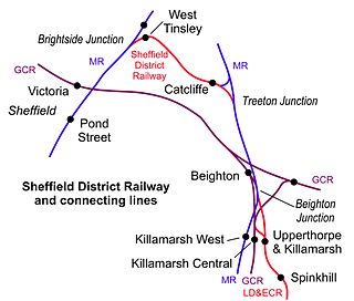
Catcliffe railway station is a former railway station in the Catcliffe area of Rotherham, South Yorkshire, England.
Longton Bridge was a railway station on the West Lancashire Railway in England. It served the village of Longton.
The Cheshire Midland Railway was authorised by an Act of Parliament, passed on 14 June 1860, to build a 12 miles 65 chains (20.6 km) railway from Altrincham on the Manchester, South Junction and Altrincham Railway (MSJAR) to Northwich.
Abington railway station was a station which served Abington, in the Scottish county of South Lanarkshire. It was served by local trains on what is now known as the West Coast Main Line. There is now no station convenient for Abington.
Thorpe on the Hill railway station was a station serving the village of Thorpe-on-the-Hill, Lincolnshire, England.
Ann Street Halt railway station served the centre of Widnes in Cheshire, England. It was located on the southern section of the former St Helens and Runcorn Gap Railway.

Newent railway station served the town of Newent.
The Worcester and Hereford Railway started the construction of a standard gauge railway between the two cities in 1858. It had needed the financial assistance of larger concerns, chiefly the Oxford, Worcester and Wolverhampton Railway, and the Newport, Abergavenny and Hereford Railway. It opened its line progressively from 1859 to 1861, delayed by exceptionally difficult tunnelling at Colwall and Ledbury. The company was purchased by the West Midland Railway in 1860, and that company amalgamated with the Great Western Railway in 1863.
Fountainhall railway station served the village of Fountainhall, Scottish Borders from 1848 to 1969 on the Waverley Route.
Muirkirk railway station was a railway station serving the village of Muirkirk, East Ayrshire, Scotland.
The Montrose and Bervie Railway was a Scottish railway. When the Aberdeen Railway opened in 1850, the coastal settlements north of Montrose were not linked in, and local interests promoted a branch line from Montrose to Bervie. They found it impossible to raise capital at first, but from 1861 the larger railways were promoting new connections around Aberdeen, and the Great North of Scotland Railway (GNoSR) decided that the Bervie line would give it a route to the south.
Haydock Park railway station was a railway station adjacent to Haydock Park Racecourse, formerly in Lancashire and now in Merseyside, England. The station's sole purpose was to handle race day traffic. It did not feature in public timetables and normal service trains passed through the station without stopping.
Golborne South railway station was one of two stations serving the town of Golborne, to the south of Wigan.

Lowton railway station served the village named Town of Lowton to the east of Newton-le-Willows and south of Golborne.
Bamfurlong railway station served the village of Bamfurlong part of Abram, to the south of Wigan.

Standish railway station is a closed railway station in Standish, England, situated where the line bridged Rectory Lane.

Gillfoot railway station was on the Whitehaven, Cleator and Egremont Railway line half a mile north of Egremont station, in Cumbria, England.
Blaenau Festiniog Junction railway station was the Festiniog Railway (FR)'s third of eventually five passenger stations in Blaenau Ffestiniog, then in Merionethshire, now in Gwynedd, Wales.
The Tenbury Railway was a standard gauge railway that connected Tenbury in Worcestershire, England, with the nearby main line at Woofferton. It opened in 1861. An independent railway company, the Tenbury and Bewdley Railway continued to Bewdley in Worcestershire, opening in 1864. The route formed by the two railways was sometimes referred to as the Wyre Forest line or simply the Tenbury Line.

