
Mount Mazama is a complex volcano in the western U.S. state of Oregon, in a segment of the Cascade Volcanic Arc and Cascade Range. Most of the mountain collapsed following a major eruption approximately 7,700 years ago. The volcano is in Klamath County, in the southern Cascades, 60 miles (97 km) north of the Oregon–California border. Its collapse, due to the eruption of magma emptying the underlying magma chamber, formed a caldera that holds Crater Lake. The mountain is in Crater Lake National Park. Mount Mazama originally had an elevation of 12,000 feet (3,700 m), but following its climactic eruption this was reduced to 8,157 feet (2,486 m). Crater Lake is 1,943 feet (592 m) deep, the deepest freshwater body in the U.S. and the second deepest in North America after Great Slave Lake in Canada.

Indian Heaven is a volcanic field in Skamania County in the state of Washington, in the United States. Midway between Mount St. Helens and Mount Adams, the field dates from the Pleistocene to the early Holocene epoch. It trends north to south and is dominated by six small shield volcanoes; these shields are topped by small spatter and cinder cones, and the field includes a number of subglacial volcanoes and tuyas. The northernmost peak in the field is Sawtooth Mountain and the southernmost is Red Mountain; its highest point is Lemei Rock at an elevation of 5,925 feet (1,806 m).
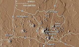
The San Francisco volcanic field is an area of volcanoes in northern Arizona, north of Flagstaff, US. The field covers 1,800 square miles (4,700 km²) of the southern boundary of the Colorado Plateau. The field contains 600 volcanoes ranging in age from nearly 6 million years old to less than 1,000 years, of which Sunset Crater is the youngest. The highest peak in the field is Humphreys Peak, at Flagstaff's northern perimeter: the peak is Arizona's highest at 12,633 feet and is a part of the San Francisco Peaks, an active stratovolcano complex.

An active volcano is a volcano that has erupted during the Holocene, is currently erupting, or has the potential to erupt in the future. A volcano that is not currently erupting but could erupt in the future is known as a dormant volcano. Volcanoes that will not erupt again are known as extinct volcanoes.
The Decade Volcanoes are 16 volcanoes identified by the International Association of Volcanology and Chemistry of the Earth's Interior (IAVCEI) as being worthy of particular study in light of their history of large, destructive eruptions and proximity to densely populated areas. The Decade Volcanoes project encourages studies and public-awareness activities at these volcanoes, with the aim of achieving a better understanding of the volcanoes and the dangers they present, and thus being able to reduce the severity of natural disasters.

The Yellowstone hotspot is a volcanic hotspot in the United States responsible for large scale volcanism in Idaho, Montana, Nevada, Oregon, and Wyoming, formed as the North American tectonic plate moved over it. It formed the eastern Snake River Plain through a succession of caldera-forming eruptions. The resulting calderas include the Island Park Caldera, Henry's Fork Caldera, and the Bruneau-Jarbidge caldera. The hotspot currently lies under the Yellowstone Caldera. The hotspot's most recent caldera-forming supereruption, known as the Lava Creek Eruption, took place 640,000 years ago and created the Lava Creek Tuff, and the most recent Yellowstone Caldera. The Yellowstone hotspot is one of a few volcanic hotspots underlying the North American tectonic plate; another example is the Anahim hotspot.
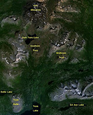
The Tuya volcanic field is a volcanic field of tuyas located in far northern British Columbia, Canada, near the border with the Yukon Territory and focused on the area of the Tuya Range, a subrange of the Stikine Ranges of the Cassiar Mountains, though some vents are in the Kawdy Plateau, the northernmost part of the Stikine Plateau. Several small shield volcanoes, and postglacial lapilli cones and lava flows have been reported in this area. The only nonglacial volcanoes in the field are Gabrielse Cone and the West Tuya lava field.

West Crater is a small lava dome with associated lava flows in southern Washington, United States. Located in Skamania County, it rises to an elevation of 4,131 feet (1,259 m), and forms part of the Cascade Volcanic Arc. It is also part of the Marble Mountain-Trout Creek Hill volcanic field, a little-known Quaternary volcanic field in the southern Cascades of Washington state. The area can be hiked, and can be accessed by roads in the Gifford Pinchot National Forest.

The Uinkaret volcanic field is an area of monogenetic volcanoes in northwestern Arizona, United States, located on the north rim of the Grand Canyon.

Devils Garden Volcanic Field is a volcanic field located south east of Newberry Caldera in Oregon. The lava field consists of several flows of pahoehoe lava that erupted from fissure vents in the northeast part of the Devils Garden. The main vent on the north end of the fissure created a lava tube system. Several small vents to the south produced the Blowouts, several small spatter cones, and flows. Several older hills and higher areas were completely surrounded by the flows to form kipukas. The distal ends of the flows show excellent examples of inflated lava.

The Squaw Ridge Lava field, also known as the East Lava Field, is a young basaltic field located in the U.S. state of Oregon southeast of Newberry Volcano. The flow erupted from the Lava Mountain shield and is likely related to the Four Craters Lava Field, both of which were created after Mount Mazama erupted.

The flows of Jordan Craters volcanic field are the youngest of a series of large Quaternary basalt fields in the eastern part of the U.S. state of Oregon. The field is thought to be approximately 3200 years old, based on findings of a lake sediment coring experiment in 1986. It was formed by basaltic pahoehoe emanating from vents throughout the area.
Trout Creek Hill is a small Pleistocene basaltic shield volcano in Washington, United States. Located in Skamania County, Trout Creek Hill rises to an elevation of 2,946 feet (898 m). It is part of the Cascade Volcanic Arc, located in the Marble Mountain-Trout Creek Hill volcanic field.

The volcanic history of the Northern Cordilleran Volcanic Province presents a record of volcanic activity in northwestern British Columbia, central Yukon and the U.S. state of easternmost Alaska. The volcanic activity lies in the northern part of the Western Cordillera of the Pacific Northwest region of North America. Extensional cracking of the North American Plate in this part of North America has existed for millions of years. Continuation of this continental rifting has fed scores of volcanoes throughout the Northern Cordilleran Volcanic Province over at least the past 20 million years and occasionally continued into geologically recent times.
Lemei Rock is a shield volcano, and part of the Indian Heaven polygenetic volcanic field in Washington, United States. It is located midway between Mount St. Helens and Mount Adams, and dates from the Pleistocene and Holocene. Lemei Rock is the highest point at 5,925 feet (1,806 m).

The Big Lava Bed, located in the Gifford Pinchot National Forest in the southwestern area of the State of Washington, originated from a 500-foot-deep crater in the northern center of the bed. The Big Lava Bed is the youngest feature of the Indian Heaven volcanic field. The 0.9-cubic kilometer lava flow erupted from the cinder cone about 8200 years ago. The lava flow traveled 13 km from the source crater. Lodgepole pine, alder, and other pioneer plants struggle to grow, seen sparsely growing between and amid towering rock piles, caves, and strange lava formations. Access into the interior of the lava bed is difficult, since there are no roads or trails crossing the lava field. Explorers who wish to venture deep within the lava flow are advised to choose their route carefully. Compasses are not always reliable, since local magnetic influences affect their magnetic performance in the vast expanse of rock.
