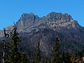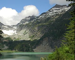
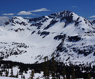
Kyes Peak, which is also known as "Goblin Peak", is a mountain peak located in the Henry M. Jackson Wilderness in Washington, United States. Kyes Peak rises to over 7,280 feet (2,220 m). Together with Columbia Peak and Monte Cristo Peak it forms a basin that contains Columbia Glacier and Blanca Lake. It is the highest summit in the Monte Cristo group of peaks.
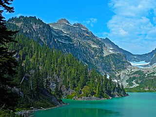
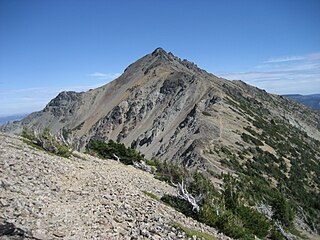
Columbia Peak is a mountain peak in the Henry M. Jackson Wilderness in the U.S. state of Washington. Columbia Peak rises to 7,172 feet (2,186 m). Together with Monte Cristo Peak and Kyes Peak it forms a basin that contains Columbia Glacier and Blanca Lake.

Bonanza Peak is a tall peak in the North Cascades in the U.S. state of Washington and the Glacier Peak Wilderness of the Wenatchee National Forest. At 9,516 feet (2,900 m) in elevation, it is the highest point in Chelan County, and the highest non-volcanic peak in Washington. and the Cascade Range as a whole. Bonanza Peak's prominence is 3,711 feet (1,131 m), making it the 26th most prominent peak in Washington. The nearest higher peak is Glacier Peak, 14.4 miles (23.2 km) to the southwest.

Buckner Mountain is a tall peak in the North Cascades of Washington state and in the Stephen Mather Wilderness of North Cascades National Park. At 9,114 feet (2,778 m) in elevation it is the highest in Skagit County and one of about ten of Washington's non-volcanic peaks above 9,000 feet high. It is ranked as the 14th highest peak in the state, and the third highest peak in North Cascades National Park.

Prairie Mountain is a 5,678-foot-elevation mountain summit near the western edge of the North Cascades, in Snohomish County of Washington state. It is located six miles east of Darrington, Washington, and northwest of Glacier Peak which is one of the Cascade stratovolcanoes. It is situated on land administered by the Mount Baker-Snoqualmie National Forest. The nearest higher peak is White Chuck Mountain, 4.7 miles (7.6 km) to the south-southeast. Precipitation runoff from Prairie Mountain drains into the Sauk River and Suiattle River, both tributaries of the Skagit River. The mountain was so named because of the beautiful prairie at its base.
Mount Aix is a 7,766-foot (2,367 m) mountain summit in Yakima County of Washington state.

Sitting Bull Mountain is a 7,759-foot (2,365-metre) double summit mountain in the North Cascades of Washington state. The north summit is higher than the south peak, and easier to climb, however neither peak sees much climbing activity. Sitting Bull Mountain is located 2.1 mi (3.4 km) northwest of Suiattle Pass in the heart of the Glacier Peak Wilderness. Its nearest higher peak is Plummer Mountain, 1.51 mi (2.43 km) to the south-southwest. The mountain is situated on the crest of the Cascade Range, on the shared border of Snohomish County and Chelan County. Precipitation runoff from Sitting Bull Mountain drains east into Agnes Creek which is a tributary of the Stehekin River, or west into Canyon Creek which is a tributary of the Suiattle River.

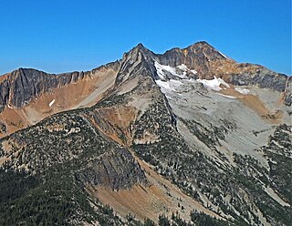
Dumbell Mountain is an 8,416-foot (2,565-metre) double summit massif located in the Glacier Peak Wilderness of the North Cascades, in Chelan County of Washington state. The Dumbell summit is slightly higher than the northeast subpeak (8,408 ft) which is unofficially called Greenwood Mountain. The nearest higher neighbor is Chiwawa Mountain, 2.4 mi (3.9 km) to the east-southeast. Precipitation runoff from Dumbell Mountain drains into tributaries of the Chelan River and the Wenatchee River. The mountain's descriptive name was applied by Albert Hale Sylvester (1871-1944), pioneer surveyor, explorer, topographer, and forest supervisor in the Cascades.
Chiwawa Mountain is an 8,459-foot (2,578-metre) mountain summit located in the Glacier Peak Wilderness of the North Cascades in Washington state. The mountain is situated on the crest of the Cascade Range, on the shared border of Snohomish County and Chelan County, also straddling the boundary between the Mount Baker-Snoqualmie National Forest and the Wenatchee National Forest. Its nearest higher peak is Fortress Mountain, 1.12 mi (1.80 km) to the west. Chiwawa Mountain is a triple divide peak, so precipitation runoff from it drains northeast to Lake Chelan via Railroad Creek; northwest into Miners Creek which is a tributary of the Suiattle River; and south into the Chiwawa River headwaters. The mountain's name is taken from the river's name, which was applied by Albert Hale Sylvester (1871-1944), a pioneer surveyor, explorer, topographer, and forest supervisor in the Cascades. Chiwawa comes from the Columbia-Moses language and means a kind of creek.

The Chopping Block is a 6,819-foot (2,078-metre) mountain summit located in the Picket Range within North Cascades National Park in the state of Washington. The mountain is officially named Pinnacle Peak on maps, but hardly anyone calls it by that name. The nearest higher peak is Mount Degenhardt, 0.6 mi (0.97 km) to the northeast. The Chopping Block can be seen from the North Cascades National Park Newhalem visitor center, weather permitting. Precipitation runoff from the peak drains into Goodell Creek, a tributary of the Skagit River.
Amphitheater Mountain is an 8,358-foot (2,548-metre) multi-peak mountain located in Okanogan County in Washington state. It is part of the Okanogan Range which is a sub-range of the North Cascades and Cascade Range. The mountain is situated on the east side of the Cascade crest, in the Pasayten Wilderness, on land administered by the Okanogan–Wenatchee National Forest. The sprawling Amphitheater Mountain has several sub-peaks including the South Peak, West Peak, and North Peak. The nearest higher peak is Cathedral Peak, 0.95 miles (1.53 km) to the north. The Pacific Northwest Trail traverses below the north slope of Amphitheater Mountain as it crosses Cathedral Pass. Precipitation runoff from Amphitheater Mountain drains west into Cathedral Fork, or east into Cathedral Creek.

Remmel Mountain, also known as Mount Remmel, is a prominent 8,685-foot (2,647-metre) mountain summit located in Okanogan County in Washington state. It is the highest point in the Cathedral Range, which is a subrange of the Okanogan Range in the North Cascades. The mountain is situated 5 miles (8.0 km) south of the Canada–United States border, on the eastern side of the Cascade crest, in the Pasayten Wilderness, on land managed by the Okanogan–Wenatchee National Forest. The nearest higher peak is Mount Lago, 16.8 miles (27.0 km) to the west-southwest, and Amphitheater Mountain lies 3.6 miles (5.8 km) to the north. Remmel is the third-highest summit of the Okanogan Range following Mount Lago (8,745 ft), and Robinson Mountain (8,726 ft). These three peaks follow Jack Mountain (9,075 ft) as the highest peaks in the Pasayten Wilderness. Remmel is the most prominent mountain in the Pasayten Wilderness. Topographic relief is significant as the summit rises approximately 2,300 feet above Andrews Creek in 0.75 mile (1.2 km). Precipitation runoff from Remmel Mountain drains into the Chewuch River basin.

Windy Peak is an 8,335-foot (2,541-metre) mountain summit located in Okanogan County in Washington state. It is part of the Okanogan Range which is a sub-range of the North Cascades and Cascade Range. The mountain is situated five miles (8.0 km) south of the Canada–United States border, on the east side of the Cascade crest, in the Pasayten Wilderness, on land managed by the Okanogan–Wenatchee National Forest. The nearest higher peak is Haystack Mountain, 9.24 miles (14.87 km) to the northwest in Canada. Precipitation runoff from Windy Peak drains into tributaries of the Methow River and Similkameen River.
Mount Lago is a prominent 8,745-foot (2,665-metre) mountain summit located in the Okanogan Range of the North Cascades, in Okanogan County of Washington state. The mountain is situated on the eastern side of the Cascade crest, in the Pasayten Wilderness, on land managed by the Okanogan–Wenatchee National Forest. The nearest higher peak is Jack Mountain, 19.5 miles (31.4 km) to the west-southwest. Mount Lago is the highest summit of the Okanogan Range, and follows only Jack Mountain {9,075 ft} as the highest peak in the Pasayten Wilderness. Lago is the fourth-most prominent mountain in the Pasayten Wilderness. Precipitation runoff from the mountain drains into tributaries of the Pasayten River and Methow River. The mountain was named for Lage Wernstedt (1878–1959), a Forest Service surveyor who made numerous first ascents of the mountains he was mapping in the North Cascades. Lago, is a play on the way Americans pronounced his name. Lage, pronounced Loggy, had a son named Lago.

Castle Peak is a prominent 8,343-foot (2,543-metre) mountain summit located in the Hozameen Range of the North Cascades, on the shared border between Okanogan County and Whatcom County of Washington state. The mountain is situated one mile (1.6 km) south of the Canada–United States border, on the Cascade crest, in the Pasayten Wilderness, on land managed by the Okanogan–Wenatchee National Forest. The nearest higher peak is Jack Mountain, 14.8 miles (23.8 km) to the south-southwest. Castle Peak is the second highest summit of the Hozameen Range following Jack Mountain. Castle Peak is the sixth-highest mountain in the Pasayten Wilderness. Precipitation runoff from the mountain drains east into Castle Creek, a tributary of the Similkameen River, or west into tributaries of the Skagit River. Topographic relief is significant as the summit rises nearly 3,000 feet above Crow Creek in 0.75 mile (1.2 km).

Tiffany Mountain is an 8,245-foot (2,513-metre) mountain summit located in Okanogan County in Washington state. It is the highest point in the Tiffany Range, which is a sub-range of the Okanogan Range. The mountain is situated on the east side of the Cascade crest, on land managed by the Okanogan–Wenatchee National Forest. The nearest higher peak is Windy Peak, 18 miles (29 km) to the north. Precipitation runoff from Tiffany Mountain drains into tributaries of the Columbia River.

Pinnacle Peak is a 7,386 ft (2,251 m) mountain summit in the North Cascades Range of Washington, United States. It is located within North Cascades National Park, between Pyramid Peak and Paul Bunyans Stump, which is the nearest higher peak. It rises steeply from Diablo Lake, one of the reservoirs on the Skagit River. It is part of a group of peaks that form the northern end of a chain running south through climbing destinations such as Colonial Peak and Snowfield Peak. Like many North Cascade peaks, Pinnacle Peak is more notable for its large, steep rise above local terrain than for its absolute elevation. Precipitation runoff from the mountain drains into Diablo Lake and Skagit River. The approach is via the Pyramid Lake Trail, starting near Diablo Dam on the North Cascades Highway. From the lake, there is route-finding up Pyramid Arm to Colonial Glacier.

Bandit Peak is a 7,625-foot (2,324-metre) double-summit granitic mountain located in the Glacier Peak Wilderness of the North Cascades, in Chelan County of Washington state. The mountain is situated east of the crest of the Cascade Range, on land managed by the Okanogan–Wenatchee National Forest. Its nearest higher neighbor is Brahma Peak, 5.9 mi (9.5 km) to the north. Bandit Peak is the ninth-highest peak on Chiwawa Ridge, and other notable peaks on this ridge include Mount Berge, Buck Mountain, Cirque Mountain, Napeequa Peak, Helmet Butte, and Chiwawa Mountain. Precipitation runoff from Bandit Peak drains west into Napeequa River; or east into the Chiwawa River.

Bannock Mountain is a 7,769-foot (2,368-metre) summit in the North Cascades of Washington state.

Baekos Peak is a 7,529-foot (2,295-metre) mountain summit in Snohomish County, Washington, United States.