Unicorn Peak is a 6,971-foot (2,125-metre) mountain summit in Lewis County of Washington state, United States. It is the highest point in the Tatoosh Range which is a sub-range of the Cascade Range. It is located in Mount Rainier National Park, south of Mount Rainier. Precipitation runoff from the mountain's small glaciers, such as Unicorn Glacier, drains into tributaries of the Cowlitz River. The descriptive name is for the mountain's resemblance to the head and horn of a unicorn. The toponym was officially adopted in 1913 by the U.S. Board on Geographic Names.

Lane Peak is a 6,012-foot (1,832-metre) mountain summit in Lewis County of Washington state. It is situated on the crest of the Tatoosh Range which is a sub-range of the Cascade Range. It is located south of Mount Rainier within Mount Rainier National Park.

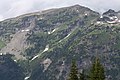
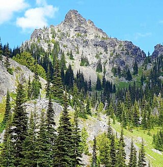
Antler Peak is a 7,017-foot (2,139-metre) summit located in Mount Rainier National Park in Pierce County of Washington state. It is part of the Sourdough Mountains, a subset of the Cascade Range. Antler Peak is situated west of Dege Peak and northeast of Sunrise Historic District, with the Sourdough Ridge Trail traversing the south slope of Antler between the two. Mount Fremont is the nearest higher peak, 1.55 mi (2.49 km) to the west. Precipitation runoff from Antler Peak drains into the White River.
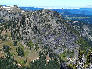
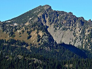
McNeeley Peak is a 6,786-foot-elevation summit located in Mount Rainier National Park in Pierce County of Washington state. It is part of the Sourdough Mountains, a subset of the Cascade Range. McNeeley Peak is situated north of the Sunrise Historic District, east of Mount Fremont, and northwest of Antler Peak. The peak was named in 1932 for Edwin J. McNeeley, a prominent Tacoma businessman. Access is limited by snow closing the Sunrise Road much of the year. July, August, and September are typically the months when the Sunrise Road is seasonally open for vehicle traffic. Precipitation runoff from McNeeley Peak drains into the White River.

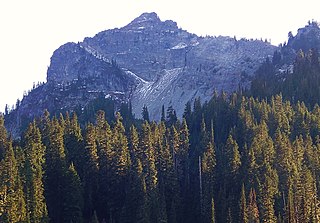
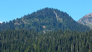
Seymour Peak is a 6,337-foot-elevation mountain summit located in Mount Rainier National Park in Pierce County of Washington state. It is part of the Cascade Range and is situated southeast of Cayuse Pass and northeast of Shriner Peak. Its nearest higher neighbor is Dewey Peak, 0.79 mi (1.27 km) to the east. Precipitation runoff from Seymour Peak drains into tributaries of the Cowlitz River. Seymour Peak is named after William Wolcott Seymour (1861-1929), mayor of Tacoma, Washington, from 1911 to 1914. He was also a philanthropist, mountaineer, and a contributor to the scouting movement. This landform's toponym was officially adopted in 1932 by the U.S. Board on Geographic Names.

Shriner Peak is a 5,834-foot-elevation mountain summit located in Mount Rainier National Park in Pierce County of Washington state. It is part of the Cascade Range and is situated south of Cayuse Pass, southwest of Seymour Peak, and southeast of Double Peak. A four mile trail leads from Highway 123 to the Shriner Peak Fire Lookout at the top of the mountain. Precipitation runoff from Shriner Peak drains into tributaries of the Cowlitz River.
Dewey Peak is a 6,710-foot (2,045 m) summit located on the shared border of Mount Rainier National Park and William O. Douglas Wilderness. It is also on the shared border of Pierce County and Yakima County in Washington state. Dewey Peak is situated on the crest of the Cascade Range southeast of Chinook Pass, east of Seymour Peak, and northeast of Shriner Peak. The nearest higher peak is Chinook Peak, 3.97 mi (6.39 km) to the north. Dewey Peak is named in association with Dewey Lake which is set below its north aspect. Precipitation runoff from Dewey Peak drains into tributaries of the Cowlitz River and Yakima River.

Yakima Peak is a 6,226-ft summit located on the eastern border of Mount Rainier National Park. It is also on the shared border of Pierce County and Yakima County in Washington state. Yakima Peak is situated northwest of Tipsoo Lake and west of Chinook Pass on the crest of the Cascade Range. Yakima Peak is a major triple divide point with precipitation runoff draining into tributaries of the White River, Cowlitz River, and Yakima River. Its nearest higher neighbor is Deadwood Peak, 0.59 mi (0.95 km) to the north. The name Yakima Peak honors the Yakima Tribe of eastern Washington state. From Chinook Pass, a short scramble up a gully on the north side leads to a flat summit with unobstructed views of Mount Rainier and Naches Peak.

Tamanos Mountain is a 6,790-foot (2,070 m) summit located in Mount Rainier National Park in Pierce County of Washington state. It is part of the Cascade Range. Tamanos Mountain is situated west of Governors Ridge and northeast of the Cowlitz Chimneys, all of which can be seen from the Sunrise Historic District. The name tamanos derives from Chinook Jargon and has the meaning of guardian spirit. This landform's toponym was officially adopted by the U.S. Board on Geographic Names in 1932. Topographic relief is significant as the summit rises 3,100 feet above the White River in approximately 1.5 mile. The normal climbing access is from the Owyhigh Lakes Trail, and from the lakes scrambling up the south slope to the summit.

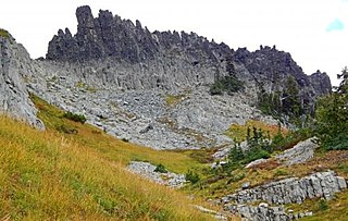
Cowlitz Chimneys are a group of four rhyolite towers located in Mount Rainier National Park in Pierce County of Washington state. As part of the Cascade Range, the Cowlitz Chimneys are situated southwest of Tamanos Mountain and east of Banshee Peak, all of which are visible from the Sunrise Historic District. The Sarvant Glacier is set on the north aspect of these remnants of a volcanic plug. Cowlitz is the name of several geographical features in Mount Rainier National Park, as well as the state of Washington. The name appeared as early as the Lewis and Clark journals of 1805 when it was written as "Cowliskee" and has the Chinook Jargon meaning of "capturing the medicine spirit".

Double Peak is a 6,199-foot (1,889 m) double summit mountain located in Mount Rainier National Park in Pierce County of Washington state. Part of the Cascade Range, it is situated northwest of Shriner Peak, south of Governors Ridge, and southeast of the Cowlitz Chimneys. Precipitation runoff from Double Peak drains into the Ohanapecosh River which is a tributary of the Cowlitz River. Topographic relief is significant as the summit rises 3,400 feet above the Ohanapecosh in one mile (1.6 km). The mountain's descriptive toponym was officially adopted in 1932 by the United States Board on Geographic Names.
The Castle is a summit in Lewis County of Washington state. It is part of the Tatoosh Range which is a sub-range of the Cascade Range. The Castle is located in Mount Rainier National Park, and it is 0.2 mile immediately east of Pinnacle Peak. Precipitation runoff from The Castle drains into tributaries of the Cowlitz River.

Barrier Peak is a small 6,521-foot (1,988-metre) summit located in Mount Rainier National Park in Pierce County of Washington state. It is part of the Cascade Range and is situated west of Cayuse Pass, 0.53 mile west-northwest of Buell Peak, and 0.4 mile south-southwest of Governors Ridge, which is its nearest higher peak. Precipitation runoff from Barrier Peak drains into tributaries of the White River and Cowlitz River. The normal climbing access is from the Owyhigh Lakes Trail. The peak was so named because it served as a barrier between the Cayuse Pass region and the rest of Mount Rainier National Park.
Three Way Peak is a 6,796 feet (2,071 m) summit located on the eastern border of Mount Rainier National Park. It is also on the shared border of Pierce County and Yakima County in Washington state. Three Way Peak is situated 0.42 mi (0.68 km) north of Cupalo Rock on the crest of the Cascade Range. Its nearest higher peak is Crystal Mountain, 0.56 mi (0.90 km) to the northwest. Chinook Peak is 0.8 mile to the southwest. Precipitation runoff from Three Way Peak drains into tributaries of the White River and Naches River.
Palisades Peak is a 7,040-foot (2,146 m) summit located in Mount Rainier National Park in Pierce County of Washington state. It is part of the Sourdough Mountains, a subset of the Cascade Range, and is situated 0.6 mile north of Marcus Peak. The peak's descriptive name stems from the resemblance of its columnar basalt cliffs to a palisade. Access is via Palisades Lakes Trail which starts at Sunrise Point. Access to Sunrise Point is limited due to snowpack closing the Sunrise Road much of the year. July, August, and September are typically the months when the Sunrise Road is seasonally open for vehicle traffic. Precipitation runoff from Palisades Peak drains into the White River.

Denman Peak is a small 6,006 ft summit in the Tatoosh Range which is a sub-range of the Cascade Range. It's located south of Mount Rainier within Mount Rainier National Park. Denman Peak is situated east of Lane Peak and west of Pinnacle Peak.

Wahpenayo Peak is a 6,231-foot (1,899-metre) mountain summit in Lewis County of Washington state, United States. It is part of the Tatoosh Range which is a sub-range of the Cascade Range. It is located south of Mount Rainier within Mount Rainier National Park. The mountain is named for Wahpenayo, a native American chief who was the father-in-law of Indian Henry. Precipitation runoff on the south and east side of the peak drains into tributaries of the Cowlitz River, whereas the north side drains into tributaries of the Nisqually River.

Foss Peak is a 6,524-foot (1,989-metre) summit in the Tatoosh Range which is a sub-range of the Cascade Range. It is located south of Mount Rainier within Mount Rainier National Park, in Lewis County of Washington state. The peak is named for Thea Foss (1857–1927), who founded the Foss Maritime Company with her husband in 1889. The peak also has an alternate name, Manatee Mountain. The nearest higher neighbor is West Unicorn Peak, 0.79 miles (1.27 km) to the southeast. Precipitation runoff from the mountain drains into tributaries of the Cowlitz River.
Buell Peak is a small 5,756 ft summit located in Mount Rainier National Park in Pierce County of Washington state. It is part of the Cascade Range and is situated 1.5 miles southwest of Cayuse Pass and 0.53 mile east-southeast of Barrier Peak, which is the nearest higher peak. Precipitation runoff from Buell Peak drains into tributaries of the Cowlitz River. The normal climbing access is from the Owyhigh Lakes Trail. The peak's toponym honors John Latimore Buell who arrived in Orting, Washington, in 1890 and went into the hardware business.

Goat Island Mountain is a 7,288-foot (2,221 m) ridge-like mountain located in Mount Rainier National Park, in Pierce County of Washington state. It is part of the Cascade Range, and lies 5.76 mi (9.27 km) east-northeast of the summit of Mount Rainier. This mountain is quite visible from the Sunrise Historic District and the many trails surrounding the Sunrise area. The Wonderland Trail provides an approach to this mountain, and the summit offers views of Cowlitz Chimneys, Fryingpan Glacier, and Mount Rainier. Burroughs Mountain is its nearest higher neighbor, 2.51 mi (4.04 km) to the northwest. Precipitation runoff from Goat Island Mountain drains into the White River. The mountain's descriptive name derives from mountain goats that were often seen on the peak. The toponym was officially adopted in 1932 by the United States Board on Geographic Names.