Mareuil Anticline

Last updated

The Mareuil Anticline, also called Mareuil-Meyssac Anticline, is a structural high within the sedimentary sequence of the northeastern Aquitaine Basin. The northwest-southeast trending anticline was caused by tectonic movements probably starting in the Upper Cretaceous.

Sediment Particulate solid matter that is deposited on the surface of land

Sediment is a naturally occurring material that is broken down by processes of weathering and erosion, and is subsequently transported by the action of wind, water, or ice or by the force of gravity acting on the particles. For example, sand and silt can be carried in suspension in river water and on reaching the sea bed deposited by sedimentation and if buried, may eventually become sandstone and siltstone.

Aquitaine Basin Mesozoic and Cenozoic sedimentary basin in France

The Aquitaine Basin is, after the Paris Basin, the second largest Mesozoic and Cenozoic sedimentary basin in France, occupying a large part of the country's southwestern quadrant. Its surface area covers 66,000 km2 onshore. It formed on Variscan basement which was peneplained during the Permian and then started subsiding in the early Triassic. The basement is covered in the Parentis Basin and in the Subpyrenean Basin—both sub-basins of the main Aquitaine Basin—by 11,000 m of sediment.

Anticline geological term

In structural geology, an anticline is a type of fold that is an arch-like shape and has its oldest beds at its core. A typical anticline is convex up in which the hinge or crest is the location where the curvature is greatest, and the limbs are the sides of the fold that dip away from the hinge. Anticlines can be recognized and differentiated from antiforms by a sequence of rock layers that become progressively older toward the center of the fold. Therefore, if age relationships between various rock strata are unknown, the term antiform should be used.

Contents

Description of the structure

A cross-section through the Mareuil Anticline with vertical exaggeration MareuilProfile.jpg
A cross-section through the Mareuil Anticline with vertical exaggeration

The anticline was named after Mareuil, a small town in the northwestern Dordogne, France. The centre of the structure is near Sainte-Croix-de-Mareuil, somewhat farther to the northwest. In plan view the anticline has the shape of an elongated pear with its long axis aligned NW-SE and reaching about 5 km in length (the Cenomanian/Turonian boundary serving as a reference horizon). The short axis is only 2 km in length. The structure is doubly asymmetric, with steeper dipping northeastern and northwestern limbs. It is accompanied on its northeastern side by the Mareuil Fault, which starts at La Rochebeaucourt and continues to the north of Brantôme. Along this fault the northeastern side of the anticline was pushed up by about 30 m.

Mareuil, Dordogne Part of Mareuil en Périgord in Nouvelle-Aquitaine, France

Mareuil, known locally as Mareuil-sur-Belle, is a former commune in the Dordogne department in Nouvelle-Aquitaine in southwestern France. On 1 January 2017, it was merged into the new commune Mareuil en Périgord. It was the birthplace of the troubadour Arnaut de Mareuil and of historian Michel Tardieu.

Dordogne Department of France in Nouvelle-Aquitaine

Dordogne is a department in Southwestern France, with its prefecture in Périgueux. The department is located in the region of Nouvelle-Aquitaine between the Loire Valley and the Pyrenees and is named after the river Dordogne that runs through it. It corresponds roughly with the ancient county of Périgord. It had a population of 416,909 in 2013.

France Republic with mainland in Europe and numerous oversea territories

France, officially the French Republic, is a country whose territory consists of metropolitan France in Western Europe and several overseas regions and territories. The metropolitan area of France extends from the Mediterranean Sea to the English Channel and the North Sea, and from the Rhine to the Atlantic Ocean. It is bordered by Belgium, Luxembourg and Germany to the northeast, Switzerland and Italy to the east, and Andorra and Spain to the south. The overseas territories include French Guiana in South America and several islands in the Atlantic, Pacific and Indian oceans. The country's 18 integral regions span a combined area of 643,801 square kilometres (248,573 sq mi) and a total population of 67.3 million. France, a sovereign state, is a unitary semi-presidential republic with its capital in Paris, the country's largest city and main cultural and commercial centre. Other major urban areas include Lyon, Marseille, Toulouse, Bordeaux, Lille and Nice.

On the southeastern side of the anticline, there are several smaller cross-cutting faults locally disturbing the angle of dip. These cross faults are all following Riedel directions, either the R- or the R'-position, hinting at an underlying shear zone.

Riedel is a German surname. Notable people with the surname include:

Shear zone structural discontinuity surface in the Earths crust and upper mantle

A shear zone is a very important structural discontinuity surface in the Earth's crust and upper mantle. It forms as a response to inhomogeneous deformation partitioning strain into planar or curviplanar high-strain zones. Intervening (crustal) blocks stay relatively unaffected by the deformation. Due to the shearing motion of the surrounding more rigid medium, a rotational, non co-axial component can be induced in the shear zone. Because the discontinuity surface usually passes through a wide depth-range, a great variety of different rock types with their characteristic structures are produced.

Regional geology

Seen from the edge of the northeastern Aquitaine Basin, the Mareuil Anticline forms the first structural high within the sedimentary cover. It runs more or less parallel with the edge of the Massif Central, at a distance of about 15 km. The sedimentary cover reaches a thickness of altogether 400 m in the anticline. In the syncline on the northeast (the Combiers-Saint-Crépin-de-Richemont Syncline), the sediments are 500 m thick. In the adjoining syncline on the southwestern side (the Gout-Rossignol-Léguillac Syncline), the sediments reach 700 m in thickness. This is followed 8 km to the southwest by another anticlinal ridge, the La Tour-Blanche Anticline. In this second anticlinal ridge, the sediments already show a thickness of 1000 m.

The La Tour-Blanche Anticline, also called Chapdeuil Anticline or Chapdeuil-La Tour-Blanche Anticline, is a tectonically caused, dome-like upwarp in the sedimentary succession of the northeastern Aquitaine Basin in France. The structure is oriented west-northwest-east-southeast.

The Mareuil Anticline is a large-scale structure. To the northwest it changes into a fault zone that can be traced from Angoulême to Isle de Yeu. To the southeast it also changes into a fault zone running from Terrasson to Meyssac. It possibly continues into the Lacassagne Fault or even into the Souillac flexure.

Angoulême Prefecture and commune in Nouvelle-Aquitaine, France

Angoulême is a commune, the capital of the Charente department, in the Nouvelle-Aquitaine region of southwestern France.

Terrasson-Lavilledieu Commune in Nouvelle-Aquitaine, France

Terrasson-Lavilledieu is a commune in the Dordogne department in Nouvelle-Aquitaine in southwestern France.

Meyssac Commune in Nouvelle-Aquitaine, France

Meyssac is a commune in the Corrèze department in central France. Its inhabitants are called the Meyssacois(es).

Stratigraphy of the sedimentary sequence

In the core of the anticline the top 20 m of Upper Jurassic (Kimmeridgian) strata are exposed — thinly bedded, cryptocrystalline, fossiliferous limestones (micrites). After a long hiatus follow 8–20 m of transgressive Cenomanian consisting of green, glauconitic marls rich in oysters and sandy, alveoline-bearing limestones. The Cenomanian is concordantly overlain by 55–65 m of Turonian strata divided into the nodular, chalky limestones of the Ligérian and the rudist-bearing limestones of the Angoumian. This is followed by 50–65 m of Coniacian — mainly hard, fossiliferous limestones. The sequence finishes with 45–60 m of chalky, glauconitic Santonian, in places rich in oyster debris.

The Jurassic period was a geologic period and system that spanned 56 million years from the end of the Triassic Period 201.3 million years ago (Mya) to the beginning of the Cretaceous Period 145 Mya. The Jurassic constitutes the middle period of the Mesozoic Era, also known as the Age of Reptiles. The start of the period was marked by the major Triassic–Jurassic extinction event. Two other extinction events occurred during the period: the Pliensbachian-Toarcian extinction in the Early Jurassic, and the Tithonian event at the end; however, neither event ranks among the "Big Five" mass extinctions.

In the geologic timescale, the Kimmeridgian is an age or stage in the Late or Upper Jurassic epoch or series. It spans the time between 157.3 ± 1.0 Ma and 152.1 ± 0.9 Ma. The Kimmeridgian follows the Oxfordian and precedes the Tithonian.

Limestone Sedimentary rocks made of calcium carbonate

Limestone is a carbonate sedimentary rock that is often composed of the skeletal fragments of marine organisms such as coral, foraminifera, and molluscs. Its major materials are the minerals calcite and aragonite, which are different crystal forms of calcium carbonate (CaCO3). A closely related rock is dolostone, which contains a high percentage of the mineral dolomite, CaMg(CO3)2. In fact, in old USGS publications, dolostone was referred to as magnesian limestone, a term now reserved for magnesium-deficient dolostones or magnesium-rich limestones.

The strata below the 120 m thick Kimmeridgian do not outcrop, but the presence of 210 m of underlying Oxfordian, Bajocian and Bathonian strata is known from drilling results in the vicinity. Whether thin Lias underlies the Dogger cannot be ascertained.

Age of movements

The northwestern edge of the Mareuil Anticline. The Turonian (Angoumian) cliff is dipping 35deg to the NNE. MareuilAnticline.jpg
The northwestern edge of the Mareuil Anticline. The Turonian (Angoumian) cliff is dipping 35° to the NNE.

The first movements in the region of the Mareuil Anticline must have occurred in the Lower Cretaceous because of the transgressive nature of the Cenomanian. But these movements were not specific to the anticline; they affected the entire northeastern Aquitaine Basin. Synsedimentary slumps in the Turonian strata near the anticline are a good indicator that the first tectonic stirrings had happened in the anticline. Yet the major event responsible for the creation of the structure clearly must have taken place after the Santonian, because the entire sedimentary sequence has been deformed by it. This major event is thought to have occurred at the end of the Campanian and during the Maastrichtian (end-Campanian-Maastrichtian event). But there is also a good possibility that the main orogenic event during the Eocene/Oligocene in the Pyrenees is somehow involved in the formation of the anticline. Like the Pyrenees, the Mareuil Anticline was created under compressive forces, maybe even under transpression. It is known that compressive forces responsible for the Pyrenean orogeny likewise affected the northeastern edge of the Massif Central (i.e. upthrusts within the Dogger can be seen in the quarry of Saint-Martial-de-Valette).

Structural observations

The Mareuil Anticline forms part of the anticlinal ridges within the northern Aquitaine Basin. These ridges follow a more or less northwesterly-southeasterly direction and run parallel to the South Armorican Shear Zone. Their age of formation is thought to be end-Campanian/Maastrichtian. Possibly they have a transpressive component and share with the South Armorican Shear Zone (SASZ) the same dextral sense of movement. Importantly they have a parallel alignment and a rather uniform spacing of 15–20 km. A local exception in this scheme is the La Tour-Blanche Anticline narrowing to a spacing of 8 km and following a WNW-ESE direction.

Related Research Articles

Los Angeles Basin geographic region in Southern California, USA

The Los Angeles Basin is a sedimentary basin located in southern California, in a region known as the Peninsular Ranges. The basin is also connected to an anomalous group of east-west trending chains of mountains collectively known as the California Transverse Ranges. The present basin is a coastal lowland area, whose floor is marked by elongate low ridges and groups of hills that is located on the edge of the Pacific plate. The Los Angeles Basin, along with the Santa Barbara Channel, the Ventura Basin, the San Fernando Valley, and the San Gabriel Basin, lies within the greater southern California region. On the north, northeast, and east, the lowland basin is bound by the Santa Monica Mountains and Puente, Elysian, Repetto hills. To the southeast, the basin is bordered by the Santa Ana mountains and the San Joaquin Hills. The western boundary of the basin is marked by the Continental Borderland and is part of the onshore portion. The California borderland is characterized by north-west trending offshore ridges and basins. The Los Angeles Basin is notable for its great structural relief and complexity in relation to its geologic youth and small size for its prolific oil production. Yerkes et al. identify 5 major stages of the basin's evolution that begins in the Upper Cretaceous and ends in the Pleistocene. This basin can be classified as an irregular pull-apart basin accompanied by rotational tectonics during the post-early Miocene.

Chalk Group

The Chalk Group is the lithostratigraphic unit which contains the Late Cretaceous limestone succession in southern and eastern England. The same or similar rock sequences occur across the wider northwest European chalk 'province'. It is characterised by thick deposits of chalk, a soft porous white limestone, deposited in a marine environment.

The Perth Basin is a thick, elongated sedimentary basin in Western Australia. It lies beneath the Swan Coastal Plain west of the Darling Scarp, representing the western limit of the much older Yilgarn Craton, and extends further west offshore. Cities and towns including Perth, Busselton, Bunbury, Mandurah and Geraldton are built over the Perth Basin.

Neuquén Group

The Neuquén Group is a group of geologic formations found in Argentina. Rocks in the Neuquén Group fall within the Cenomanian to early Campanian stages of the Late Cretaceous Period. It overlies the older Lohan Cura Formation and is itself overlain by the younger Allen Formation of the Malargüe Group, separated from both by unconformities, dated to 98 and 79 Ma respectively.

Gulf of Suez Rift A continental rift zone that was active between the Late Oligocene and the end of the Miocene

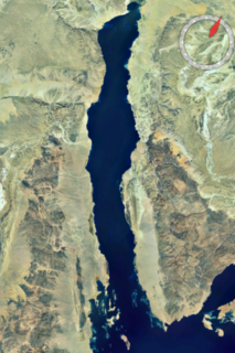
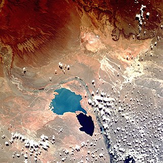
The Gulf of Suez Rift is a continental rift zone that was active between the Late Oligocene and the end of the Miocene. It represented a continuation of the Red Sea Rift until break-up occurred in the middle Miocene, with most of the displacement on the newly developed Red Sea spreading centre being accommodated by the Dead Sea Transform. During its brief post-rift history, the deepest part of the remnant rift topography has been filled by the sea, creating the Gulf of Suez.

Tremp Formation

The Tremp Formation, alternatively described as Tremp Group, is a geological formation in the comarca Pallars Jussà, Lleida, Spain. The formation is restricted to the Tremp or Tremp-Graus Basin, a piggyback foreland basin in the Catalonian Pre-Pyrenees. The formation dates to the Maastrichtian to Thanetian, thus the formation includes the Cretaceous-Paleogene boundary that has been well studied in the area, using paleomagnetism and carbon and oxygen isotopes. The formation comprises several lithologies, from sandstone, conglomerates and shales to marls, siltstones, limestones and lignite and gypsum beds and ranges between 250 and 800 metres in thickness. The Tremp Formation was deposited in a continental to marginally marine fluvial-lacustrine environment characterized by estuarine to deltaic settings.

The Straight Cliffs Formation is a stratigraphic unit in the Kaiparowits Plateau of south central Utah. It is Late Cretaceous in age and contains fluvial, paralic, and marginal marine (shoreline) siliciclastic strata. It is well exposed around the margin of the Kaiparowits Plateau in the Grand Staircase – Escalante National Monument in south central Utah. The formation is named after the Straight Cliffs, a long band of cliffs creating the topographic feature Fiftymile Mountain.

Neuquén Basin

Neuquén Basin is a sedimentary basin covering most of Neuquén Province in Argentina. The basin originated in the Jurassic and developed through alternating continental and marine conditions well into the Tertiary. The basin bounds to the west with the Andean Volcanic Belt, to the southeast with the North Patagonian Massif and to the northeast with the San Rafael Block and to the east with the Sierra Pintada System. The basin covers an area of approximately 120,000 square kilometres (46,000 sq mi). One age of the SALMA classification, the Colloncuran, is defined in the basin, based on the Collón Curá Formation, named after the Collón Curá River, a tributary of the Limay River.

Geology of the Pyrenees

The Pyrenees are a 430-kilometre-long, roughly east–west striking, intracontinental mountain chain that divide France, Spain, and Andorra. The belt has an extended, polycyclic geological evolution dating back to the Precambrian. The chain's present configuration is due to the collision between the microcontinent Iberia and the southwestern promontory of the European Plate. The two continents were approaching each other since the onset of the Upper Cretaceous (Albian/Cenomanian) about 100 million years ago and were consequently colliding during the Paleogene (Eocene/Oligocene) 55 to 25 million years ago. After its uplift, the chain experienced intense erosion and isostatic readjustments. A cross-section through the chain shows an asymmetric flower-like structure with steeper dips on the French side. The Pyrenees are not solely the result of compressional forces, but also show an important sinistral shearing.

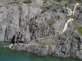
The Génis Unit is a Paleozoic metasedimentary succession of the southern Limousin and belongs geologically to the Variscan basement of the French Massif Central. The unit covers the age range Cambrian/Ordovician till Devonian.

The Angoumian is a geological group restricted to the northern Aquitaine Basin in France. The group consists of two fossiliferous limestone formations deposited during the Turonian.

The Ligérian is a regional geological substage of the Turonian. It designates sediments of the Lower Turonian in western France.

Geology of the Isle of Wight

The geology of the Isle of Wight is dominated by sedimentary rocks of Cretaceous and Paleogene age. This sequence was affected by the late stages of the Alpine Orogeny, forming the Isle of Wight monocline, the cause of the steeply-dipping outcrops of the Chalk Group and overlying Paleogene strata seen at The Needles, Alum Bay and Whitecliff Bay.

The Winchester-East Meon Anticline is one of a series of parallel east-west trending folds in the Cretaceous chalk of Hampshire. It lies at the western end of the South Downs, immediately to the north of the Hampshire Basin and south-east of Salisbury Plain.

The geology of West Sussex in southeast England comprises a succession of sedimentary rocks of Cretaceous age overlain in the south by sediments of Palaeogene age. The sequence of strata from both periods consists of a variety of sandstones, mudstones, siltstones and limestones. These sediments were deposited within the Hampshire and Weald basins. Erosion subsequent to large scale but gentle folding associated with the Alpine Orogeny has resulted in the present outcrop pattern across the county, dominated by the north facing chalk scarp of the South Downs. The bedrock is overlain by a suite of Quaternary deposits of varied origin. Parts of both the bedrock and these superficial deposits have been worked for a variety of minerals for use in construction, industry and agriculture.

The geology of Nigeria formed beginning in the Archean and Proterozoic eons of the Precambrian. The country forms the Nigerian Province and more than half of its surface is igneous and metamorphic crystalline basement rock from the Precambrian. Between 2.9 billion and 500 million years ago, Nigeria was affected by three major orogeny mountain-building events and related igneous intrusions. Following the Pan-African orogeny, in the Cambrian at the time that multi-cellular life proliferated, Nigeria began to experience regional sedimentation and witnessed new igneous intrusions. By the Cretaceous period of the late Mesozoic, massive sedimentation was underway in different basins, due to a large marine transgression. By the Eocene, in the Cenozoic, the region returned to terrestrial conditions.

The geology of Syria includes ancient metamorphic rocks from the Precambrian belonging to the Arabian Craton, as well as numerous marine sedimentary rocks and some erupted basalt up to recent times.

References

Coordinates: 45°28′N0°25′E / 45.467°N 0.417°E / 45.467; 0.417