Massadona, Colorado

Last updated

Massadona is an unincorporated community in Moffat County, in the U.S. state of Colorado. [1]

Contents

History

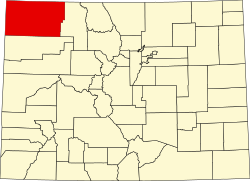
Massadona was founded sometime prior to 1907, and was known as Boxelder. Although the origin of the name Massadona is unknown, it is possible that the original name of Boxelder came from a local creek, which is called Box Elder Creek. The name was changed between 1910 and 1954, possibly to avoid confusion with Box Elder in Adams County. [2]

The post office in Dinosaur serves Massadona addresses. [3]

Climate

According to the Köppen Climate Classification system, Massadona has a cold semi-arid climate, abbreviated "BSk" on climate maps. The hottest temperature recorded in Massadona was 102 °F (38.9 °C) on July 21, 2005, while the coldest temperature recorded was −29 °F (−33.9 °C) on December 22, 1990. [4]

Climate data for Massadona, Colorado, 1991–2020 normals, extremes 1986–2009
MonthJanFebMarAprMayJunJulAugSepOctNovDecYear
Record high °F (°C)56
(13)
62
(17)
77
(25)
81
(27)
95
(35)
96
(36)
102
(39)
100
(38)
93
(34)
82
(28)
68
(20)
62
(17)
102
(39)
Average high °F (°C)33.0
(0.6)
38.9
(3.8)
50.8
(10.4)
59.2
(15.1)
68.7
(20.4)
81.6
(27.6)
88.3
(31.3)
86.0
(30.0)
76.5
(24.7)
62.1
(16.7)
46.7
(8.2)
33.7
(0.9)
60.5
(15.8)
Daily mean °F (°C)22.4
(−5.3)
27.1
(−2.7)
38.3
(3.5)
45.6
(7.6)
55.0
(12.8)
65.7
(18.7)
72.6
(22.6)
70.4
(21.3)
61.4
(16.3)
48.5
(9.2)
35.4
(1.9)
22.8
(−5.1)
47.1
(8.4)
Average low °F (°C)11.8
(−11.2)
15.3
(−9.3)
25.8
(−3.4)
32.0
(0.0)
41.3
(5.2)
49.7
(9.8)
56.9
(13.8)
54.8
(12.7)
46.3
(7.9)
34.9
(1.6)
24.0
(−4.4)
12.0
(−11.1)
33.7
(1.0)
Record low °F (°C)−7
(−22)
−25
(−32)
−8
(−22)
7
(−14)
20
(−7)
28
(−2)
41
(5)
37
(3)
22
(−6)
0
(−18)
−8
(−22)
−29
(−34)
−29
(−34)
Average precipitation inches (mm)1.09
(28)
1.03
(26)
1.25
(32)
1.32
(34)
1.59
(40)
0.85
(22)
0.97
(25)
0.96
(24)
1.56
(40)
1.63
(41)
1.04
(26)
1.08
(27)
14.37
(365)
Average snowfall inches (cm)13.3
(34)
8.1
(21)
4.6
(12)
2.9
(7.4)
1.0
(2.5)
0.0
(0.0)
0.0
(0.0)
0.0
(0.0)
0.0
(0.0)
4.3
(11)
6.9
(18)
10.1
(26)
51.2
(131.9)
Average precipitation days (≥ 0.01 in)7.57.46.68.58.05.74.97.06.76.65.75.680.2
Average snowy days (≥ 0.1 in)6.65.53.12.20.40.00.00.00.01.53.94.828.0
Source 1: NOAA [5]
Source 2: XMACIS2 [4]

Related Research Articles

<span class="mw-page-title-main">Chicken, Alaska</span> Census designated place in Alaska, USA

Chicken is a tiny unincorporated village in Southeast Fairbanks Census Area, Alaska. It is a community founded on gold mining, and is one of the few surviving gold rush towns in Alaska. The population was 12 at the time of the 2020 census, up from 7 in 2010. However, usually year round, there are 17 inhabitants: due to mining, Chicken's population peaks during the summer. It has frequently been noted on lists of unusual place names. There is a cafe with gas station, a small hotel, an RV park, a small general store and a saloon located at Chicken.

<span class="mw-page-title-main">Northglenn, Colorado</span> City in Colorado, United States

The City of Northglenn is a home rule municipality located in Adams and Weld counties, Colorado, United States. Northglenn is a part of the Denver–Aurora–Lakewood, CO Metropolitan Statistical Area. As of the 2020 census the city's population was 38,131. It was built as a master planned community in 1959 by Jordon Perlmutter.

<span class="mw-page-title-main">Stearns, Kentucky</span> Census-designated place in Kentucky, United States

Stearns is an unincorporated community and census-designated place (CDP) in McCreary County, Kentucky, United States. The population was 1,365 at the 2020 census. It was founded by Justus Smith Stearns.

<span class="mw-page-title-main">Steele, North Dakota</span> City in North Dakota, United States

Steele is a city in Kidder County, North Dakota, United States. It is the county seat of Kidder County. The population was 665 at the 2020 census.

<span class="mw-page-title-main">Basin, Wyoming</span> Town in Wyoming, United States

Basin is a town in, and the county seat of, Big Horn County, Wyoming, United States. The population was 1,225 at the 2020 census. The community is located near the center of the Bighorn Basin with the Big Horn River east of the town. Basin's post office, built in 1919, is listed on the National Register of Historic Places.

<span class="mw-page-title-main">Climate of Missouri</span>

Missouri generally has a variety of seasonal humid subtropical climate, with cool winters and long, hot summers. In the southern part of the state, particularly in the Bootheel, the climate borders on a more mild-type humid subtropical climate, and in the northern third, the state transitions into a humid continental climate. Because of its location in the interior United States, Missouri often experiences extremes in temperatures. Lacking either large mountains or oceans nearby to moderate its temperature, its climate is alternately influenced by air from the cold Arctic and the hot and humid Gulf of Mexico.

<span class="mw-page-title-main">Cape Hatteras</span> Cape on the shoreline of Hatteras Island, North Carolina, United States

Cape Hatteras is a cape located at a pronounced bend in Hatteras Island, one of the barrier islands of North Carolina.

<span class="mw-page-title-main">Climate of Virginia</span> Overview of the climate of the U.S. state of Virginia

The climate of Virginia, a state on the east coast of the United States, is considered mild compared to more northern areas of the United States such as New England and the Midwest. Most of Virginia east of the Blue Ridge mountains, the southern part of the Shenandoah Valley, and the Roanoke Valley, has a humid subtropical climate. In the mountainous areas west of the Blue Ridge, the climate is warm-summer humid continental or oceanic climate. Severe weather, in the form of tornadoes, tropical cyclones, and winter storms, impacts the state on a regular basis. Central Virginia received significant snowfall of 20 inches in December 2009.

<span class="mw-page-title-main">Geography of Louisville, Kentucky</span>

Louisville is a city in Jefferson County, in the U.S. state of Kentucky. It is located at the Falls of the Ohio River.

<span class="mw-page-title-main">Boysen State Park</span> Recreation area in Fremont County, Wyoming

Boysen State Park is a public recreation area surrounding the Boysen Reservoir, an impoundment of the north-flowing Wind River, in Fremont County, Wyoming. The state park covers more than 35,000 acres (14,000 ha) at the south end of the Owl Creek Mountains at the mouth of the Wind River Canyon.

<span class="mw-page-title-main">Climate of California</span> Overview of the climate of the U.S. state of California

The climate of California varies widely from hot desert to alpine tundra, depending on latitude, elevation, and proximity to the Pacific Coast. California's coastal regions, the Sierra Nevada foothills, and much of the Central Valley have a Mediterranean climate, with warmer, drier weather in summer and cooler, wetter weather in winter. The influence of the ocean generally moderates temperature extremes, creating warmer winters and substantially cooler summers in coastal areas.

<span class="mw-page-title-main">Gateway, Colorado</span> Unincorporated community in Mesa County, Colorado

Gateway is an unincorporated community and a U.S. Post Office located in Mesa County, Colorado, United States.

<span class="mw-page-title-main">Climate of North Dakota</span>

North Dakota's climate is typical of a continental climate with cold winters and warm-hot summers. The state's location in the Upper Midwest allows it to experience some of the widest variety of weather in the United States, and each of the four seasons has its own distinct characteristics. The eastern half of the state has a humid continental climate with warm to hot, somewhat humid summers and cold, windy winters, while the western half has a semi-arid climate with less precipitation and less humidity but similar temperature profiles. The areas east of the Missouri River get slightly colder winters, while those west of the stream get higher summer daytime temperatures. In general, the diurnal temperature difference is prone to be more significant in the west due to higher elevation and less humidity.

<span class="mw-page-title-main">Young America, Indiana</span> Unincorporated community in Indiana, United States

Young America is an unincorporated community in Deer Creek Township, Cass County, Indiana.

<span class="mw-page-title-main">Geography of Memphis, Tennessee</span>

The City of Memphis is located on the eastern bank of the Mississippi River in the southwest corner of the U.S. state of Tennessee. It is the regional hub for a tri-state area of Arkansas, Mississippi and Tennessee.

<span class="mw-page-title-main">Geography of Nevada</span> Overview of the Geography of Nevada

The landlocked U.S. state of Nevada has a varied geography and is almost entirely within the Basin and Range Province and is broken up by many north–south mountain ranges. Most of these ranges have endorheic valleys between them.

<span class="mw-page-title-main">Scott Lake (Washington)</span>

Scott Lake is a lake in Thurston County, Washington, United States. It is located 3.2 miles (5.1 km) south of the Tumwater city limits, 8.4 miles (13.5 km) south of the Olympia city limits, and 14.1 miles (22.7 km) north of the Centralia city limits. The location for Scott Lake is in Sections 33 and 34, Township 17N, Range 2W, Willamette Meridian.

<span class="mw-page-title-main">Wild Horse, Nevada</span> Unincorporated community in the state of Nevada, United States

Wild Horse is an unincorporated community in Elko County, Nevada, United States. It is located along Nevada State Route 225 just south of Wild Horse Reservoir, from which it derives its name.

Luna is an unincorporated community in southern Marshall County, Minnesota, United States.

South Lincoln is a census-designated place (CDP) within the town of Lincoln, Addison County, Vermont, United States. It was first listed as a CDP prior to the 2020 census.

References

  1. "Massadona". Geographic Names Information System . United States Geological Survey, United States Department of the Interior . Retrieved September 29, 2021.
  2. "TopoView" . Retrieved September 5, 2021.
  3. "United States Zip Codes" . Retrieved September 5, 2021.
  4. 1 2 "xmACIS2". National Oceanic and Atmospheric Administration. Retrieved July 7, 2023.
  5. "U.S. Climate Normals Quick Access – Station: Massadona 3E, CO". National Oceanic and Atmospheric Administration. Retrieved July 7, 2023.

40°15′10″N108°38′25″W / 40.25278°N 108.64028°W / 40.25278; -108.64028