Meridianville, Alabama

Last updated

Meridianville, Alabama
Madison County Alabama Incorporated and Unincorporated areas Meridianville Highlighted.svg
Location in Madison County and the state of Alabama
Coordinates: 34°52′9″N86°34′42″W / 34.86917°N 86.57833°W / 34.86917; -86.57833
Country United States
State Alabama
County Madison
Area
[1]
  Total15.61 sq mi (40.42 km2)
  Land15.56 sq mi (40.29 km2)
  Water0.05 sq mi (0.13 km2)
Elevation
[2]
784 ft (239 m)
Population
 (2020) [3]
  Total8,209
  Density527.7/sq mi (203.74/km2)
Time zone UTC-6 (Central (CST))
  Summer (DST) UTC-5 (CDT)
ZIP code
35759
Area code 256
FIPS code 01-48112
GNIS feature ID2403279 [2]

Meridianville is an unincorporated community and census-designated place (CDP) in Madison County, Alabama, United States, and is included in the Huntsville-Decatur Combined Statistical Area. As of the 2020 census, the population of the CDP was 8,209. [3]

Contents

Geography

Meridianville is located in northern Madison County at 34°52′10″N86°34′42″W / 34.86944°N 86.57833°W / 34.86944; -86.57833 (34.869312, -86.578373). [4] It is north of Huntsville and east of Harvest and is bordered by Hazel Green to the north and Moores Mill to the east. It is the third largest community in Madison County by population after Huntsville and Madison.

According to the U.S. Census Bureau, the Meridianville CDP has a total area of 15.6 square miles (40 km2), of which 15.5 square miles (40 km2) are land and 0.1 square miles (0.26 km2), or 0.31%, are water. [1]

Education

Meridianville is served by the following public schools:

Demographics

Historical population
CensusPop.Note
1880 105
1980 1,403
1990 2,852103.3%
2000 4,11744.4%
2010 6,02146.2%
2020 8,20936.3%
U.S. Decennial Census [5]

Meridianville first appeared on the 1880 U.S. Census as an unincorporated community of 105 residents. It did not appear again on the census for a century (1980), when it was designated a census designated place (CDP).

2000 census

As of the census [6] of 2000, there were 4,117 people, 1,492 households, and 1,250 families living in the community. The population density was 263.0 inhabitants per square mile (101.5/km2). There were 1,565 housing units at an average density of 100.0 per square mile (38.6/km2). The racial makeup of the community was 86.62% White, 9.40% Black or African American, 1.07% Native American, 0.73% Asian, 0.05% Pacific Islander, 0.19% from other races, and 1.94% from two or more races. 0.70% of the population were Hispanic or Latino of any race.

There were 1,492 households, out of which 40.5% had children under the age of 18 living with them, 72.8% were married couples living together, 8.8% had a female householder with no husband present, and 16.2% were non-families. 14.7% of all households were made up of individuals, and 4.6% had someone living alone who was 65 years of age or older. The average household size was 2.76 and the average family size was 3.05.

In the community, the population was spread out, with 27.5% under the age of 18, 6.3% from 18 to 24, 31.4% from 25 to 44, 25.1% from 45 to 64, and 9.6% who were 65 years of age or older. The median age was 38 years. For every 100 females, there were 97.7 males. For every 100 females age 18 and over, there were 96.1 males.

The median income for a household in the community was $54,766, and the median income for a family was $61,367. Males had a median income of $42,274 versus $29,241 for females. The per capita income for the community was $23,626. About 2.9% of families and 4.2% of the population were below the poverty line, including 3.9% of those under age 18 and none of those age 65 or over.

2010 census

As of the census [7] of 2010, there were 6,021 people, 2,248 households, and 1,743 families living in the community. The population density was 262.2 inhabitants per square mile (101.2/km2). There were 2,353 housing units at an average density of 151.8 per square mile (58.6/km2). The racial makeup of the community was 76.3% White, 18.5% Black or African American, .7% Native American, 1.7% Asian, 0.2% Pacific Islander, 0.7% from other races, and 2.0% from two or more races. 2.7% of the population were Hispanic or Latino of any race.

There were 2,248 households, out of which 33.8% had children under the age of 18 living with them, 63.7% were married couples living together, 10.1% had a female householder with no husband present, and 22.5% were non-families. 19.3% of all households were made up of individuals, and 6.3% had someone living alone who was 65 years of age or older. The average household size was 2.68 and the average family size was 3.08.

In the community, the population was spread out, with 25.6% under the age of 18, 6.9% from 18 to 24, 26.5% from 25 to 44, 28.9% from 45 to 64, and 12.0% who were 65 years of age or older. The median age was 38.9 years. For every 100 females, there were 93.4 males. For every 100 females age 18 and over, there were 91.4 males.

The median income for a household in the community was $68,864, and the median income for a family was $76,449. Males had a median income of $55,956 versus $36,100 for females. The per capita income for the community was $26,834. About 2.4% of families and 5.8% of the population were below the poverty line, including 5.8% of those under age 18 and 6.4% of those age 65 or over.

2020 census

Meridianville racial composition [8]
RaceNum.Perc.
White (non-Hispanic)5,11462.3%
Black or African American (non-Hispanic)2,05124.98%
Native American 570.69%
Asian 1311.6%
Pacific Islander 110.13%
Other/Mixed 4956.03%
Hispanic or Latino 3504.26%

As of the 2020 United States census, there were 8,209 people, 2,759 households, and 2,020 families residing in the CDP.

Education

The local school district is Madison County Schools. [9]

Related Research Articles

<span class="mw-page-title-main">Hazel Green, Alabama</span> Census-designated place in Alabama, United States

Hazel Green is an unincorporated community and census-designated place (CDP) in Madison County, Alabama, United States, and is included in the Huntsville-Decatur Combined Statistical Area. As of the 2020 census, the population of the community was 4,105, up from 3,630 at the 2010 census.

<span class="mw-page-title-main">Moores Mill, Alabama</span> Census-designated place in Alabama, United States

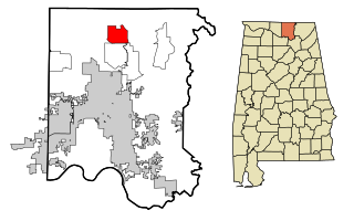
Moores Mill is an unincorporated community and census-designated place (CDP) in Madison County, Alabama, United States, and is included in the Huntsville-Decatur Combined Statistical Area. The population was 6,729 at the 2020 census, up from 5,682 at the 2010 census.

<span class="mw-page-title-main">New Market, Alabama</span> Census-designated place in Alabama, United States

New Market is an unincorporated community and census-designated place (CDP) in Madison County, Alabama, United States, and is included in the Huntsville-Decatur Combined Statistical Area. As of the 2020 census, the population of the CDP was 1,543. Although it was the first area settled in Madison County, the town has never been incorporated.

<span class="mw-page-title-main">Mignon, Alabama</span> CDP in Alabama, United States

Mignon is a census-designated place (CDP) in Talladega County, Alabama, United States. At the 2020 census, the population was 1,186.

<span class="mw-page-title-main">Tsaile, Arizona</span> Census-designated place in Arizona, United States

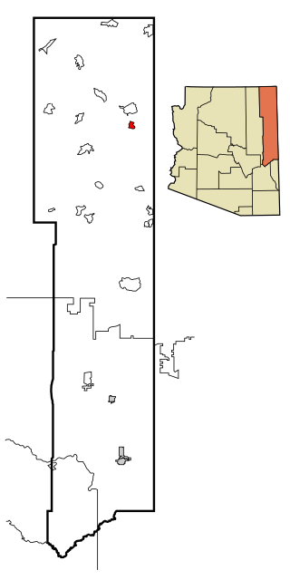
Tsaile is a census-designated place (CDP) in Apache County, Arizona, United States, on the Navajo Nation. The population was 1,205 at the 2010 census.

<span class="mw-page-title-main">Channel Lake, Illinois</span> Census-designated place in Illinois, United States

Channel Lake is an unincorporated community and census-designated place (CDP) in Antioch Township, Lake County, Illinois, United States. Per the 2020 census, the population was 1,581.

<span class="mw-page-title-main">Spokane, Missouri</span> Census-designated place in Missouri, United States

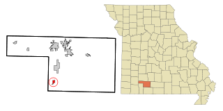
Spokane is a census-designated place in Christian County, Missouri, United States. The population was 177 at the 2010 census. It is part of the Springfield, Missouri, Metropolitan Statistical Area.

<span class="mw-page-title-main">Madison Park, New Jersey</span> Populated place in Middlesex County, New Jersey, US

Madison Park is an unincorporated community and census-designated place (CDP) located within Old Bridge Township, in Middlesex County, in the U.S. state of New Jersey. As of the 2010 United States Census, the CDP's population was 7,144. The name "Madison Park" reflects Old Bridge's original name of "Madison Township" which it had when it was formed on March 2, 1869 from portions of South Amboy Township, until November 5, 1975, when voters approved a referendum changing the township's name to Old Bridge Township.

<span class="mw-page-title-main">Upper Fruitland, New Mexico</span> CDP in New Mexico, United States

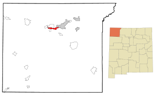
Upper Fruitland is a census-designated place (CDP) in San Juan County, New Mexico, United States. The population was 1,664 at the 2000 census. It is part of the Farmington Metropolitan Statistical Area.

Leeds is a hamlet and census-designated place (CDP) in Greene County, New York, United States. The population was 429 at the 2020 census.

<span class="mw-page-title-main">South Lockport, New York</span> CDP in New York, United States

South Lockport is a hamlet located in the Town of Lockport in Niagara County, New York, United States. The population was 8,234 at the 2010 census. It is part of the Buffalo–Niagara Falls Metropolitan Statistical Area.

<span class="mw-page-title-main">Glenmoor, Ohio</span> Census-designated place in Ohio, United States

Glenmoor is an unincorporated community and census-designated place in southwestern St. Clair Township, Columbiana County, Ohio, United States. The population was 1,829 at the 2020 census. Glenmoor is located in the Salem micropolitan area and the greater Youngstown–Warren area.

<span class="mw-page-title-main">Masury, Ohio</span> Census-designated place in Ohio, United States

Masury is an unincorporated community and census-designated place in eastern Trumbull County, Ohio, United States. The population was 2,001 at the 2020 census. It is part of the Youngstown–Warren metropolitan area.

<span class="mw-page-title-main">South Canal, Ohio</span> Census-designated place in Ohio, United States

South Canal is an unincorporated community and census-designated place in western Newton Township, Trumbull County, Ohio, United States. The population was 1,101 at the 2020 census. It is part of the Youngstown–Warren metropolitan area.

<span class="mw-page-title-main">Pine Ridge, South Dakota</span> CDP in South Dakota, United States

Pine Ridge is a census-designated place (CDP) and the most populous community in Oglala Lakota County, South Dakota, United States. The population was 3,138 at the 2020 census. It is the tribal headquarters of the Oglala Sioux Tribe on the Pine Ridge Indian Reservation.

<span class="mw-page-title-main">Merrifield, Virginia</span> Census-designated place in Virginia, United States

Merrifield is a census-designated place (CDP) in Fairfax County, Virginia, United States. The population was 20,488 at the 2020 census.

<span class="mw-page-title-main">Okauchee Lake, Wisconsin</span> CDP in Wisconsin, United States

Okauchee Lake is a census-designated place (CDP) in Waukesha County, Wisconsin, United States. The population was 5,094 at the 2020 census. Okauchee Lake is located in the town of Oconomowoc.

<span class="mw-page-title-main">Bedford (CDP), New York</span> Census-designated place in New York, United States

Bedford is a hamlet and census-designated place (CDP) located in the town of Bedford in Westchester County, New York, United States. The population was 1,834 at the 2010 census.

<span class="mw-page-title-main">Windsor, Wisconsin</span> Village in Wisconsin, United States

Windsor is a village and former town in Dane County, Wisconsin. The population was 8,754 at the time of the 2020 census. The communities of Lake Windsor, Morrisonville, and Token Creek are located within the village. Windsor voted to incorporate as a village on November 3, 2015; prior to its incorporation, it was a town, and a portion of the town was a census-designated place. Windsor is a part of the Census Bureau's Madison metropolitan statistical area.

<span class="mw-page-title-main">Kapaʻa, Hawaii</span> Census-designated place in Hawaii, United States

Kapaʻa is an unincorporated community and census-designated place (CDP) in Kauaʻi County, Hawaiʻi, United States. It is the most populous town in the island of Kauai, with a population of 11,652 as of the 2020 census, up from 9,471 at the 2000 census.

References

  1. 1 2 "2021 U.S. Gazetteer Files". United States Census Bureau. Retrieved April 6, 2022.
  2. 1 2 U.S. Geological Survey Geographic Names Information System: Meridianville, Alabama
  3. 1 2 "Meridianville CDP, Alabama: 2020 DEC Redistricting Data (PL 94-171)". U.S. Census Bureau. Retrieved April 6, 2022.
  4. "US Gazetteer files: 2010, 2000, and 1990". United States Census Bureau. February 12, 2011. Retrieved April 23, 2011.
  5. "Census of Population and Housing". Census.gov. Retrieved June 4, 2016.
  6. "U.S. Census website". United States Census Bureau . Retrieved January 31, 2008.
  7. "U.S. Census website". United States Census Bureau . Retrieved August 2, 2015.
  8. "Explore Census Data". data.census.gov. Retrieved December 17, 2021.
  9. "2020 CENSUS - SCHOOL DISTRICT REFERENCE MAP: Madison County, AL" (PDF). U.S. Census Bureau . Retrieved August 1, 2022. - Text list