Owens Cross Roads, Alabama

Last updated

Owens Cross Roads, Alabama
OCRflyover.png
Old-Hwy-431-north-al.jpg
Fields of Owens Cross Roads.jpg
Neighborhood Pond.jpg
An Owens Cross Roads Neighborhood.jpg
Cross at Redemption Church.jpg
Clockwise from top:
  • Overlooking Owens Cross Roads US 431
  • Old Highway 431 in the Center of Owens Cross Roads
  • A field in Owens Cross Roads
  • A neighborhood pond
  • A neighborhood street
  • Sunday morning sunrise
Flag of Owens Cross Roads, Alabama.png
Seal of Owens Cross Roads, Alabama.png
Madison County Alabama Incorporated and Unincorporated areas Owens Cross Roads Highlighted 0157504.svg
Location of Owens Cross Roads in Madison County, Alabama
Coordinates: 34°35′10″N86°27′31″W / 34.58611°N 86.45861°W / 34.58611; -86.45861
CountryUnited States
State Alabama
County Madison
Incorporated October 9, 1967 [1]
Government
   Mayor Tony Craig
Area
[2]
  Total7.970 sq mi (20.642 km2)
  Land7.852 sq mi (20.338 km2)
  Water0.118 sq mi (0.306 km2)
Elevation
[3]
584 ft (178 m)
Population
 (2020) [4]
  Total2,594
  Estimate 
(2022) [5]
2,652
  Density334/sq mi (129.1/km2)
Time zone UTC–6 (Central (CST))
  Summer (DST) UTC–5 (CDT)
ZIP Code
35763
Area code(s) 256 and 938
FIPS code 01-57504
GNIS feature ID2407060 [3]
Website owenscrossroadsal.org

Owens Cross Roads is a town in Madison County, Alabama, United States, and is included in the Huntsville-Decatur Combined Statistical Area. It was incorporated on October 9, 1967. [6] The population was 2,594 at the 2020 census. [4] it is home to brazelton cemetery

Contents

History

The area has a history that can be dated back to the early 1800’s. Pioneers had drifted into the area from Tennessee, Virginia, North Carolina, South Carolina and Georgia with names such as Wood, Parker, Craig, Craft, Maples, Carpenter and Brannum, but a gentleman named Thomas J. Owens had migrated from Virginia and was the first to build his family home near an intersection of two roads.

The name Owens Cross Roads was very appropriately chosen since the Owens home was at “the cross roads”. The community grew in size at a steady pace over the years as a large frame business house was erected near the intersection, containing a post office (established 1861 [7] ), general store and blacksmith shop. [8] Owens Cross Roads first appeared on maps in 1850. [7]

Following the Civil War, the population grew as businesses sprang up and a new school was erected to replace the original log schoolhouse. With the turn of the 20th century came new growth to the neighboring towns of Huntsville and Guntersville, making Owens Cross Roads a welcome stop for travelers between the two larger towns. The town relied heavily on cotton cultivation throughout much of its early history, with some crop diversification coming in the 1920s and 1930s. [7]

Incorporation

Owens Cross Roads Police and Volunteer Fire on a scene OCRPublicSafety.jpg
Owens Cross Roads Police and Volunteer Fire on a scene

Incorporated in 1967, the Owens Cross Roads City Hall sits facing Highway 431 South, a busy corridor of modern life. The city proudly boasts of having the first Blue Ribbon School in Madison County, a highly praised Volunteer Fire Department and a Police Department dedicated to serve and protect the citizens of Owens Cross Roads. [8]

Geography

Looking off Green Mountain to the Owens Cross Roads area below. Overlooking Owens Cross Roads, AL from Green Mountain.jpg
Looking off Green Mountain to the Owens Cross Roads area below.

Owens Cross Roads is located at 34°35′10″N86°27′31″W / 34.58611°N 86.45861°W / 34.58611; -86.45861 (34.586071, -86.458561). [9] The city is situated in a broad valley carved by the Flint River. Rugged hills and mountains surround the town, including Green Mountain to the west, and Keel Mountain to the east. Huntsville lies across Green Mountain to the northwest, New Hope lies just to the southeast, and Paint Rock lies across Keel Mountain to the northeast. U.S. Route 431 passes through Owens Cross Roads, connecting the town with Huntsville and Guntersville. Owens Cross Roads met the threshold to become a city in 2020 with the population exceeding 2,000 persons under Alabama law [10]

According to the United States Census Bureau, the city has a total area of 7.970 square miles (20.64 km2), of which 7.852 square miles (20.34 km2) is land and 0.118 square miles (0.31 km2), is water. [2]

Demographics

Historical population
CensusPop.Note
1970 767
1980 8044.8%
1990 695−13.6%
2000 1,12461.7%
2010 1,52135.3%
2020 2,59470.5%
2022 (est.)2,652 [5] 2.2%
U.S. Decennial Census [11]
2020 Census [4]

2020 census

Owens Cross Roads racial composition [12]
RaceNumberPercent
White (non-Hispanic)1,99276.79%
Black or African American (non-Hispanic)2017.75%
Native American 351.35%
Asian 291.12%
Pacific Islander 40.15%
Other/Mixed 2128.17%
Hispanic or Latino 1214.66%

As of the 2020 census, there were 2,594 people, 978 households, and 718 families residing in the town. [13] There were 1,032 housing units.

2010 census

As of the 2010 census, there were 1,521 people, 593 households, and 409 families in the town. The population density was 183 inhabitants per square mile (71/km2). There were 650 housing units at an average density of 78.3 per square mile (30.2/km2). The racial makeup of the town was 91.5% White, 3.6% Black or African American, 1.0% Native American, 0.3% Asian, 0.6% from other races, and 3.0% from two or more races. 2.2% of the population were Hispanic or Latino of any race.

Of the 593 households 30.4% had children under the age of 18 living with them, 53.3% were married couples living together, 10.5% had a female householder with no husband present, and 31.0% were non-families. 27.0% of households were one person and 8.7% were one person aged 65 or older. The average household size was 2.41 and the average family size was 2.91.

The age distribution was 23.1% under the age of 18, 7.8% from 18 to 24, 28.3% from 25 to 44, 23.9% from 45 to 64, and 16.9% 65 or older. The median age was 38.1 years. For every 100 females, there were 97.0 males. For every 100 females age 18 and over, there were 107.0 males.

The median household income was $40,625 and the median family income was $43,750. Males had a median income of $43,889 versus $33,393 for females. The per capita income for the town was $21,542. About 23.6% of families and 31.2% of the population were below the poverty line, including 60.9% of those under age 18 and 6.1% of those age 65 or over.

2000 census

As of the 2000 census, there were 1,124 people, 443 households, and 329 families residing in the town. The population density was 145.8 people per square mile (56.3/km2). There were 482 housing units at an average density of 62.5 per square mile (24.1/km2). The racial makeup of the town was 95.64% White, 0.71% Black or African American, 0.71% Native American, 0.27% Asian, 0.36% from other races, and 2.31% from two or more races. 0.62% of the population were Hispanic or Latino of any race.

There were 443 households out of which 29.8% had children under the age of 18 living with them, 60.0% were married couples living together, 9.9% had a female householder with no husband present, and 25.7% were non-families. 21.9% of all households were made up of individuals and 8.6% had someone living alone who was 65 years of age or older. The average household size was 2.47 and the average family size was 2.88.

In the town the population was spread out with 23.3% under the age of 18, 8.4% from 18 to 24, 29.6% from 25 to 44, 24.7% from 45 to 64, and 14.0% who were 65 years of age or older. The median age was 38 years. For every 100 females there were 95.8 males. For every 100 females age 18 and over, there were 95.0 males.

The median income for a household in the town was $34,856, and the median income for a family was $45,167. Males had a median income of $30,781 versus $22,917 for females. The per capita income for the town was $17,534. About 4.6% of families and 7.1% of the population were below the poverty line, including 8.9% of those under age 18 and 11.8% of those age 65 or over.

Education

The local school district is Madison County Schools. [14]

Notable people

Related Research Articles

<span class="mw-page-title-main">Madison County, Alabama</span> County in Alabama, United States

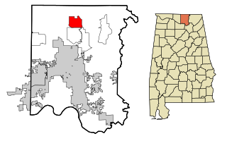
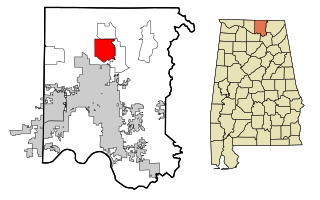
Madison County is located in the north central portion of the U.S. state of Alabama. As of the 2020 Census, the population was 388,153, making it the second-most populous county in Alabama. Its county seat is Huntsville. Since the mid-20th century it has become an area of defense and space research and industry.

<span class="mw-page-title-main">Rosa, Alabama</span> Town in Alabama, United States

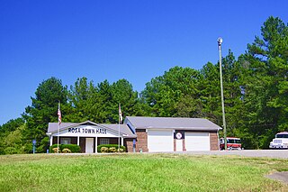
Rosa is a town in Blount County, Alabama, United States. At the 2020 census, the population was 376.

<span class="mw-page-title-main">Arab, Alabama</span> City in Alabama, United States

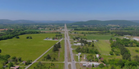
Arab is a city in Marshall County in the northern part of the U.S. state of Alabama, located 10 miles (16 km) from Guntersville Lake and Guntersville Dam, and is included in the Huntsville-Decatur Combined Statistical Area. The population was 8,461 at the 2020 census.

<span class="mw-page-title-main">Good Hope, Alabama</span> City in Alabama, United States

Good Hope is a city in Cullman County, Alabama, United States. As of the 2010 census, the population of the city was 2,264. It incorporated in April 1962.

<span class="mw-page-title-main">Paint Rock, Alabama</span> Town in Alabama, United States

Paint Rock is a town in Jackson County, Alabama, United States, along the Paint Rock River, and is included in the Huntsville-Decatur Combined Statistical Area. It was incorporated in July 1894.

<span class="mw-page-title-main">Woodville, Alabama</span> Town in Alabama, United States

Woodville is a town in Jackson County, Alabama, United States. It was officially established by an act of the Alabama State Legislature on December 13, 1819, one day before Alabama became a state. It was later incorporated on May 12, 1890, but lost its charter in 1897. It reincorporated in 1912. As of the 2010 census, the population of the town is 746, down from 761 in 2000.

<span class="mw-page-title-main">Rogersville, Alabama</span> Town in Alabama, United States

Rogersville is a town in Lauderdale County, Alabama, United States. As of the 2018 census, the population of the town is 1,231, up from 1,199 in 2000.

<span class="mw-page-title-main">Hillsboro, Alabama</span> Town in Alabama, United States

Hillsboro is a town in Lawrence County, Alabama, and is included in the Decatur Metropolitan Area, as well as the Huntsville-Decatur Combined Statistical Area. It was incorporated in 1899. As of the 2010 census, the population of the town is 552, down from its record high of 608 in 2000. Along with North Courtland, it is one of two majority black communities in Lawrence County out of its six populated communities as of 2010.

<span class="mw-page-title-main">North Courtland, Alabama</span> Town in Alabama, United States

North Courtland is a town in Lawrence County, Alabama, United States, and is included in the Decatur Metropolitan Area, as well as the Huntsville-Decatur Combined Statistical Area. It incorporated in 1981. At the 2010 census, the population of the town was 632, down from 799 in 2000. Along with Hillsboro, it is one of two majority black communities in Lawrence County out of its six populated communities as of 2010.

<span class="mw-page-title-main">Ardmore, Alabama</span> Town in Alabama, United States

Ardmore is a town in Limestone County, Alabama, United States, and is included in the Huntsville-Decatur Metro Area. The population was 1,321 at the 2020 census, It borders its sister city Ardmore, Tennessee.

<span class="mw-page-title-main">Lester, Alabama</span> Town in Alabama, United States

Lester is a town in Limestone County, Alabama, United States, and is included in the Huntsville-Decatur Combined Statistical Area. As of the 2010 census, the population of the town is 111, up from 107 in 2000.

<span class="mw-page-title-main">Hazel Green, Alabama</span> Census-designated place in Alabama, United States

Hazel Green is an unincorporated community and census-designated place (CDP) in Madison County, Alabama, United States, and is included in the Huntsville-Decatur Combined Statistical Area. As of the 2020 census, the population of the community was 4,105, up from 3,630 at the 2010 census.

<span class="mw-page-title-main">Meridianville, Alabama</span> Census-designated place in Alabama, United States

Meridianville is an unincorporated community and census-designated place (CDP) in Madison County, Alabama, United States, and is included in the Huntsville-Decatur Combined Statistical Area. As of the 2020 census, the population of the CDP was 8,209.

<span class="mw-page-title-main">Moores Mill, Alabama</span> Census-designated place in Alabama, United States

Moores Mill is an unincorporated community and census-designated place (CDP) in Madison County, Alabama, United States, and is included in the Huntsville-Decatur Combined Statistical Area. The population was 6,729 at the 2020 census, up from 5,682 at the 2010 census.

<span class="mw-page-title-main">New Hope, Alabama</span> City in Alabama, United States

New Hope is a city in Madison County, Alabama, United States, and is included in the Huntsville-Decatur Combined Statistical Area. The population was 2,889 at the 2020 census.

<span class="mw-page-title-main">New Market, Alabama</span> Census-designated place in Alabama, United States

New Market is an unincorporated community and census-designated place (CDP) in Madison County, Alabama, United States, and is included in the Huntsville-Decatur Combined Statistical Area. As of the 2020 census, the population of the CDP was 1,543. Although it was the first area settled in Madison County, the town has never been incorporated.

<span class="mw-page-title-main">Triana, Alabama</span> Town in Alabama, United States

Triana is a town in Madison County, Alabama, United States, and is included in the Huntsville-Decatur, AL Combined Statistical Area. The population was 2,890 at the 2020 census, and was estimated to be 3,961 in 2022.

<span class="mw-page-title-main">Grant, Alabama</span> Town in Alabama, United States

Grant is a town in Marshall County, Alabama, United States. As of the 2020 census, the population of Grant was 1,039, up from 896 at the 2010 census. It is included in the Huntsville-Decatur Combined Statistical Area. The town was incorporated on November 15, 1945, with Delbert Hodges serving as the first mayor.

<span class="mw-page-title-main">Falkville, Alabama</span> Town in Alabama, United States

Falkville is a town in Morgan County, Alabama, United States, and is included in the Decatur Metropolitan Area and Huntsville-Decatur Combined Statistical Area. As of the 2020 census, the population of the town was 1,197.

<span class="mw-page-title-main">Trinity, Alabama</span> Town in Alabama, United States

Trinity is a town in Morgan County, Alabama, United States. It is included in the Decatur Metropolitan Area and the Huntsville-Decatur Combined Statistical Area. As of the 2020 census, the population of the town was 2,526, up from 2,095 in 2010. It was incorporated in 1901.

References

  1. "Municipalities of Alabama Incorporation Dates" (PDF). Alabama League of Municipalities. Retrieved March 11, 2024.
  2. 1 2 "2023 U.S. Gazetteer Files". United States Census Bureau. Retrieved March 11, 2024.
  3. 1 2 U.S. Geological Survey Geographic Names Information System: Owens Cross Roads, Alabama
  4. 1 2 3 "Explore Census Data". United States Census Bureau . Retrieved March 11, 2024.
  5. 1 2 "City and Town Population Totals: 2020–2022". United States Census Bureau. March 11, 2024. Retrieved March 11, 2024.
  6. 1 2 Christopher Maloney, "Owens Cross Roads," Encyclopedia of Alabama, July 1, 2014.
  7. 1 2 3 "Owens Cross Roads".
  8. 1 2 "History of OCR – Owens Cross Roads, Alabama".
  9. "US Gazetteer files: 2010, 2000, and 1990". United States Census Bureau. February 12, 2011. Retrieved April 23, 2011.
  10. "Code of Alabama". Code of Alabama 11-40-6. Alabama Legislature. Retrieved September 15, 2021.
  11. "Census of Population and Housing". United States Census Bureau. Retrieved June 4, 2015.
  12. "Explore Census Data". data.census.gov. Retrieved December 17, 2021.
  13. "US Census Bureau, Table P16: Household Type". United States Census Bureau. Retrieved March 11, 2024.
  14. "2020 CENSUS - SCHOOL DISTRICT REFERENCE MAP: Madison County, AL" (PDF). United States Census Bureau . Retrieved August 1, 2022. - Text list