
Madison County is located in the north central portion of the U.S. state of Alabama. As of the 2020 Census, the population was 388,153, making it the third-most populous county in Alabama. Its county seat is Huntsville. Since the mid-20th century it has become an area of defense and space research and industry.

Huntsville is the most populous city in the U.S. state of Alabama. It is the county seat of Madison County with portions extending into Limestone County and Morgan County. It is located in the Appalachian region of northern Alabama.
Owens Cross Roads is a city in Madison County, Alabama, United States, and is included in the Huntsville-Decatur Combined Statistical Area. It was incorporated in 1967. As of the 2020 census, the population of the city was 2,594. The City has a mayor-council form of government.

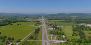
U.S. Route 72 (US 72) is an east–west United States highway that travels for 317.811 miles (511.467 km) from southwestern Tennessee, throughout North Mississippi, North Alabama, and southeastern Tennessee. The highway's western terminus is in Memphis, Tennessee and its eastern terminus is in Chattanooga. It is the only U.S. Highway to begin and end in the same state, yet pass through other states in between. Prior to the U.S. Highway system signage being posted in 1926, the entire route was part of the Lee Highway.
Monte Sano Mountain is a mountain located in Huntsville, Alabama. The name Monte Sano is Spanish for "Mountain of health". The mountain was given its name by Dr. Thomas Fern, who along with his two brothers, founded a small colony on the mountain during an epidemic of yellow fever, malaria, and cholera. The location on the mountain was chosen because of its cool air and medicinal springs.
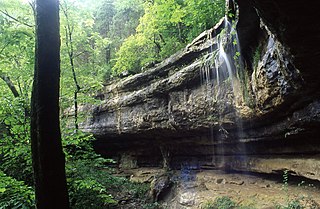
Monte Sano State Park is a public recreation area and mountaintop retreat encompassing 2,140 acres (870 ha) on the eastern portion of the top and slopes of Monte Sano Mountain on the east side of Huntsville, Alabama. The state park has 1930s-era, Civilian Conservation Corps–built rustic cottages, hiking trails and picnic areas with scenic overlooks, and modern campsites. It is managed by the Alabama Department of Conservation and Natural Resources.

A destructive tornado outbreak struck a wide swath of the Southern and Eastern United States as well as Canada on November 15 and 16, 1989. It produced at least 40 tornadoes and caused 30 deaths as a result of two deadly tornadoes. The most devastating event was the Huntsville, Alabama F4 tornado, which killed 21 on the afternoon of November 15. Nine more fatalities occurred at a single elementary school by an F1 tornado on November 16 in Newburgh, New York, although further survey revealed that this might have been a downburst instead. This outbreak also produced the most tornadoes in a single day in New Jersey, later tied on April 1, 2023. Several other significant tornadoes were reported across 15 states.
Hampton Cove is a master-planned housing subdivision located in Big Cove area of Huntsville, Alabama. Situated in the foothills and valleys of North Alabama's Cumberland Plateau, the 2,800-acre (11 km2) Housing lies in the coves between Monte Sano Mountain and Green Mountain to the west, and Keel Mountain to the east.

The Huntsville-Decatur-Albertville, AL Combined Statistical Area is the most populated sub-region of North Alabama, and is the second largest Combined Statistical Area in the State of Alabama after Birmingham. The Huntsville-Decatur-Albertville CSA had a total of 879,315 people in 2022 and ranks 68th in the country.

WHNT-TV is a television station in Huntsville, Alabama, United States, affiliated with CBS. It is owned by Nexstar Media Group alongside Florence-licensed CW owned-and-operated station WHDF. The two stations share studios on Holmes Avenue Northwest in downtown Huntsville; WHNT-TV's transmitter is located on Monte Sano Mountain. The station also operates three news bureaus: Decatur, Sand Mountain (Albertville), and Shoals (Florence).
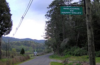
Happy Valley is an unincorporated community in Blount County, Tennessee, near the Great Smoky Mountains National Park. Although it is not a census-designated place, the ZIP Code Tabulation Area for the ZIP Code (37878) that serves Happy Valley had a population of 529 as of the 2000 U.S. Census.

Whitethorn is an unincorporated community in Humboldt County, California, United States. It is located 9.5 miles southwest of Garberville, at an elevation of 1,024 feet, with a population of 817. Whitethorn shares a ZIP Code, 95589, with Shelter Cove, California. It is located along California's Lost Coast.

Walland is an unincorporated community and census-designated place (CDP) in Blount County, Tennessee. Its population was 281 as of the 2020 census. Walland is the site of a post office and is the place name associated with zip code 37886, which covers an area beyond the Walland community.
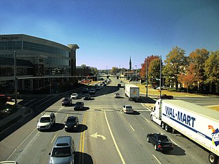
Governors Drive is a major east–west thoroughfare in Huntsville, Alabama. It follows U.S. Route 431 (US-431) in east Huntsville and State Route 53 (SR-53) in west Huntsville. Governors Drive is one of the main entrance points to the city from the east, carrying on average approximately 48,000 vehicles a day across Monte Sano Mountain.

An extensive collection of parks and greenways exists in Huntsville, Alabama for the public's recreational use.

Sherwood is an unincorporated community in Franklin County, Tennessee, United States. It is located along Tennessee State Route 56 13.1 miles (21.1 km) southeast of Winchester, and just north of the Alabama state line. Sherwood has a post office with ZIP code 37376.
Monte Sano Nature Preserve is, at 1,107 acres (448 ha), one of the largest urban nature preserves in the US and is located on Monte Sano Mountain in Huntsville, Alabama. The Land Trust of North Alabama manages the nature preserve and Land Trust volunteers have created 23+ miles of public trails. Residents and visitors alike enjoy the multi-use trails for hiking, biking, running, bird watching, environmental education, and general recreation. The trail system was honored in 2011 by the Department of the Interior as National Recreation Trails making them the first NRT trails in Madison County.
The following is a timeline of the history of the city of Huntsville, Alabama, USA.
Salsbury Cove is an unincorporated village in the town of Bar Harbor, Hancock County, Maine, United States. The community is located along Maine State Route 3, 10.3 miles (16.6 km) southeast of Ellsworth. Salsbury Cove has a post office with ZIP code 04672.


