Mi-Wuk Village, California

Last updated
Mi-Wuk Village
Tuolumne County California Incorporated and Unincorporated areas Mi-Wuk Village Highlighted.svg
Location in Tuolumne County and the state of California
Usa edcp location map.svg
Red pog.svg
Mi-Wuk Village
Location in the United States
Coordinates: 38°3′40″N120°11′15″W / 38.06111°N 120.18750°W / 38.06111; -120.18750
Country Flag of the United States (23px).png  United States
State Flag of California.svg  California
County Tuolumne
Area
[1]
  Total2.784 sq mi (7.210 km2)
  Land2.778 sq mi (7.196 km2)
  Water0.006 sq mi (0.015 km2)  0.20%
Elevation
4,678 ft (1,426 m)
Population
 (2010)
  Total941
  Density340/sq mi (130/km2)
Time zone UTC-8 (Pacific (PST))
  Summer (DST) UTC-7 (PDT)
ZIP code
95346
Area code 209
FIPS code 06-48298
GNIS feature ID0277556

Mi-Wuk Village is a census-designated place (CDP) in Tuolumne County, California, United States. The population was 941 at the 2010 census, down from 1,485 at the 2000 census. It was named after the Miwok Indians by the real estate developer and promoter Harry Hoeffler in 1955. [2] [3] [4]

Contents

Geography

Mi-Wuk Village is located at 38°3′40″N120°11′15″W / 38.06111°N 120.18750°W / 38.06111; -120.18750 (38.061053, -120.187524). [5]

According to the United States Census Bureau, the CDP has a total area of 2.8 square miles (7.2 km2), of which 99.80% is land and 0.20% is water.

Climate

This region experiences warm (but not hot) and dry summers, with no average monthly temperatures above 71.6 °F. According to the Köppen Climate Classification system, Mi-Wuk Village has a warm-summer Mediterranean climate, abbreviated "Csb" on climate maps. [6]

Climate data for Mi-Wuk Village, California
MonthJanFebMarAprMayJunJulAugSepOctNovDecYear
Record high °F (°C)73
(23)
74
(23)
80
(27)
84
(29)
92
(33)
99
(37)
105
(41)
103
(39)
99
(37)
93
(34)
82
(28)
76
(24)
105
(41)
Mean daily maximum °F (°C)48.5
(9.2)
50.8
(10.4)
54.1
(12.3)
59.8
(15.4)
68.8
(20.4)
78.4
(25.8)
87.2
(30.7)
86.6
(30.3)
79.7
(26.5)
69
(21)
55.9
(13.3)
49.2
(9.6)
65.7
(18.7)
Mean daily minimum °F (°C)28.6
(−1.9)
29.1
(−1.6)
30.9
(−0.6)
34.6
(1.4)
42.1
(5.6)
49.3
(9.6)
55.9
(13.3)
55.3
(12.9)
50.1
(10.1)
42.3
(5.7)
34.1
(1.2)
29.3
(−1.5)
40.1
(4.5)
Record low °F (°C)4
(−16)
−2
(−19)
6
(−14)
14
(−10)
22
(−6)
29
(−2)
39
(4)
35
(2)
30
(−1)
17
(−8)
12
(−11)
−3
(−19)
−3
(−19)
Average precipitation inches (cm)9
(23)
7.9
(20)
6.6
(17)
4
(10)
2
(5.1)
0.7
(1.8)
0.1
(0.25)
0.2
(0.51)
0.9
(2.3)
2.6
(6.6)
5.6
(14)
7.6
(19)
47.2
(119.56)
Average snowfall inches (cm)24.8
(63)
23.9
(61)
23.8
(60)
13.8
(35)
1.4
(3.6)
0.1
(0.25)
0
(0)
0
(0)
0
(0)
0.5
(1.3)
8.1
(21)
21
(53)
117.4
(298.15)
Source: Weatherbase [7]

Demographics

2010

The 2010 United States Census [8] reported that Mi-Wuk Village had a population of 941. The population density was 338.0 inhabitants per square mile (130.5/km2). The racial makeup of Mi-Wuk Village was 871 (92.6%) White, 5 (0.5%) African American, 17 (1.8%) Native American, 3 (0.3%) Asian, 0 (0.0%) Pacific Islander, 11 (1.2%) from other races, and 34 (3.6%) from two or more races. Hispanic or Latino of any race were 71 persons (7.5%).

The Census reported that 941 people (100% of the population) lived in households, 0 (0%) lived in non-institutionalized group quarters, and 0 (0%) were institutionalized.

There were 417 households, out of which 96 (23.0%) had children under the age of 18 living in them, 221 (53.0%) were opposite-sex married couples living together, 38 (9.1%) had a female householder with no husband present, 20 (4.8%) had a male householder with no wife present. There were 26 (6.2%) unmarried opposite-sex partnerships, and 6 (1.4%) same-sex married couples or partnerships. 100 households (24.0%) were made up of individuals, and 47 (11.3%) had someone living alone who was 65 years of age or older. The average household size was 2.26. There were 279 families (66.9% of all households); the average family size was 2.68.

The population was spread out, with 160 people (17.0%) under the age of 18, 61 people (6.5%) aged 18 to 24, 175 people (18.6%) aged 25 to 44, 343 people (36.5%) aged 45 to 64, and 202 people (21.5%) who were 65 years of age or older. The median age was 50.9 years. For every 100 females, there were 104.1 males. For every 100 females age 18 and over, there were 97.2 males.

There were 1,159 housing units at an average density of 416.3 per square mile (160.7/km2), of which 321 (77.0%) were owner-occupied, and 96 (23.0%) were occupied by renters. The homeowner vacancy rate was 4.7%; the rental vacancy rate was 11.5%. 706 people (75.0% of the population) lived in owner-occupied housing units and 235 people (25.0%) lived in rental housing units.

2000

As of the census [9] of 2000, there were 1,485 people, 601 households, and 430 families residing in the CDP. The population density was 441.5 inhabitants per square mile (170.5/km2). There were 1,268 housing units at an average density of 377.0 per square mile (145.6/km2). The racial makeup of the CDP was 92.53% White, 0.13% African American, 0.94% Native American, 0.40% Asian, 0.13% Pacific Islander, 1.55% from other races, and 4.31% from two or more races. Hispanic or Latino of any race were 6.33% of the population.

There were 601 households, out of which 28.8% had children under the age of 18 living with them, 61.2% were married couples living together, 6.3% had a female householder with no husband present, and 28.3% were non-families. 22.5% of all households were made up of individuals, and 8.0% had someone living alone who was 65 years of age or older. The average household size was 2.47 and the average family size was 2.86.

In the CDP the population was spread out, with 23.9% under the age of 18, 6.3% from 18 to 24, 20.7% from 25 to 44, 31.5% from 45 to 64, and 17.6% who were 65 years of age or older. The median age was 44 years. For every 100 females, there were 100.4 males. For every 100 females age 18 and over, there were 99.6 males.

The median income for a household in the CDP was $51,925, and the median income for a family was $52,019. Males had a median income of $43,750 versus $26,071 for females. The per capita income for the CDP was $26,209. About 5.9% of families and 8.8% of the population were below the poverty line, including 9.9% of those under age 18 and none of those age 65 or over.

Government

In the California State Legislature, Mi-Wuk Village is in the 8th Senate District , represented by Democrat Angelique Ashby, and the 5th Assembly District , represented by Republican Joe Patterson. [10]

In the United States House of Representatives, Mi-Wuk Village is in California's 5th congressional district , represented by Republican Tom McClintock. [11]

See also

Related Research Articles

<span class="mw-page-title-main">Alpine Village, California</span> Census-designated place in California, United States

Alpine Village is a census-designated place (CDP) in Alpine County, California, United States. The population was 114 at the 2010 census, down from 136 at the 2000 census.

<span class="mw-page-title-main">Vallecito, California</span> Census-designated place in California, United States

Vallecito is a census-designated place (CDP) in Calaveras County, California, United States. The population was 442 at the 2010 census, up from 427 at the 2000 census. The town is registered as California Historical Landmark #273. Nearby is Moaning Cavern, the largest cave chamber in California, which the Miwok Indians used as a burial ground.

<span class="mw-page-title-main">Shingle Springs, California</span> Census-designated place in California, United States

Shingle Springs is a census-designated place (CDP) in El Dorado County, California, United States. The population was 4,432 at the 2010 census, up from 2,643 at the 2000 census. It is located about 40 miles (64 km) from Sacramento in the Gold Country foothills and sits directly on Highway 50. The towns of Coloma and Placerville are less than 15 miles (24 km) away.

<span class="mw-page-title-main">Mayflower Village, California</span> Census-designated place in California, United States

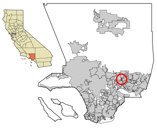
Mayflower Village is a census-designated place (CDP) in the San Gabriel Valley, in Los Angeles County, California, United States. The population was 5,515 at the 2010 census, up from 5,081 at the 2000 census. The ZIP Codes serving the community are 91006, which is served by Arcadia and 91016, which is served by Monrovia.

<span class="mw-page-title-main">Dillon Beach, California</span> Census-designated place in California, United States

Dillon Beach is a census-designated place (CDP) in Marin County, California, United States. It is located 3.25 miles (5.2 km) west of Tomales, at an elevation of 89 ft (27 m). The population was 246 at the 2020 census. Dillon Beach was named after the founder, George Dillon, who settled there in 1858. The area includes a public access beach, as well as a private beach resort, the only private beach in California.

<span class="mw-page-title-main">Tomales, California</span> Census-designated place in California, United States

Tomales is a census-designated place (CDP) on State Route 1 in Marin County, California, United States. The population was 187 at the 2020 census.

<span class="mw-page-title-main">Yosemite Valley, California</span> Census-designated place in California, United States

Yosemite Valley is a census-designated place (CDP) in Mariposa County, California, United States. It consists of the developed area of Yosemite Village and the other areas of the Yosemite Valley in Yosemite National Park. The population was 337 at the 2020 census.

<span class="mw-page-title-main">Sunnyside–Tahoe City, California</span> Census-designated place in California, United States

Sunnyside–Tahoe City is a census-designated place (CDP) in Placer County, California, located on the northwest shore of Lake Tahoe. The population was 1,557 at the 2010 census, down from 1,761 at the 2000 census, and a total area of 3.4 sq mi (8.8 km2), all of it land. It comprises two communities, Sunnyside, and Tahoe City.

<span class="mw-page-title-main">Lincoln Village, California</span> Census-designated place in California, United States

Lincoln Village is a census-designated place (CDP) in San Joaquin County, California, United States. The population was 4,381 at the 2010 census, up from 4,216 at the 2000 census.

<span class="mw-page-title-main">Glen Ellen, California</span> Census designated place in California, United States

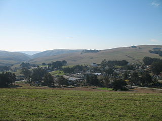
Glen Ellen is a census-designated place (CDP) in Sonoma Valley, Sonoma County, California, United States. The population was 784 at the 2010 census, down from 992 at the 2000 census. Glen Ellen is the location of Jack London State Historic Park, Sonoma Valley Regional Park, and a former home of Hunter S. Thompson.

<span class="mw-page-title-main">Temelec, California</span> Census-designated place in California, United States

Temelec is a census-designated place (CDP) in Sonoma County, California, United States. The population was 1,441 at the 2010 census.

<span class="mw-page-title-main">Jamestown, California</span> Census-designated place in California, United States

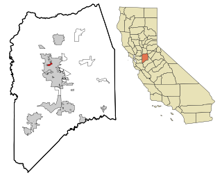
Jamestown is a census-designated place (CDP) in Tuolumne County, California, United States. The population was 3,433 at the 2010 census, up from 3,017 at the 2000 census. Formerly a California Gold Rush town, Jamestown is a California Historical Landmark since March 16, 1949. It is the home of Railtown 1897 State Historic Park and the Sierra Railway, which operates steam passenger trains.

<span class="mw-page-title-main">Zephyrhills South, Florida</span> CDP in Florida, United States

Zephyrhills South is a census-designated place (CDP) in Pasco County, Florida, United States. The population was 4,435 at the 2000 census.

<span class="mw-page-title-main">Maugansville, Maryland</span> CDP in Maryland, United States

Maugansville is a census-designated place (CDP) in Washington County, Maryland, United States. The population was 2,295 at the 2000 census.

<span class="mw-page-title-main">Lakeland Village, California</span> Census-designated place in California, United States

Lakeland Village is a census-designated place (CDP) in Riverside County, California, United States. The population was 11,541 at the 2010 census, more than double the 5,626 reported at the 2000 census.

Red Butte is a census-designated place (CDP) in Natrona County, Wyoming, United States. It is part of the Casper, Wyoming Metropolitan Statistical Area. The population was 1,430 at the 2020 census.

Buena Vista is a census-designated place in Amador County, California. It lies at an elevation of 295 feet. It is located 4 miles (6.4 km) south-southeast of Ione, at 38°17′40″N120°54′48″W. The community is in ZIP code 95640 and area code 209. The population was 429 at the 2010 census.

Valley Ford is an unincorporated community and census-designated place (CDP) in western Sonoma County, California, United States. It is located on State Route 1 north of San Francisco. Like all of Sonoma County, Valley Ford is included in both the San Francisco Bay Area and the Redwood Empire.

Salmon Creek is an unincorporated community settlement and census-designated place (CDP) in Sonoma County, California, U.S. It is located on the Pacific coast about 90 minutes drive north of San Francisco, between the towns of Jenner and Bodega Bay, California. The population was 86 at the 2010 census.

Sierra Village is a census-designated place (CDP) in Tuolumne County, California. It is located roughly 1½ miles northeast of Mi-Wuk Village on State Route 108. Sierra Village sits at an elevation of 4,787 feet (1,459 m). The 2010 United States census reported Sierra Village's population was 456.

References

  1. "2010 Census Gazetteer Files - Places - California". United States Census Bureau . Retrieved March 26, 2015.
  2. Erwin Gustav Gudde (1969). California Place Names. U. of California Press. p. 51. Named in 1955 after the nearby Miwok Indian village.
  3. Robert I. Alotta (1994). Signposts and Settlers. Bonus Books. p. 347. ISBN   978-1-56625-028-3. the Mi-Wuk or Miwok Indians, who had their reservation about 10 miles from town. The name was selected by Harry Hoeffler, who developed the community in 1955 after consulting with Chief Fuller of the Miwok tribe.
  4. The Pony Express. Vol. 29–31. N.H. Robotham. 1962. p. 94. Harry Hoeffler, ardent promoter of Mi-Wuk Village, who operates real estate offices in San Mateo and Los Altos, is a real Lion, attending regular meetings at all places.
  5. "US Gazetteer files: 2010, 2000, and 1990". United States Census Bureau. 2011-02-12. Retrieved 2011-04-23.
  6. Climate Summary for Mi-Wuk Village, California
  7. Mi Wuk Village, California Travel Weather Averages (Weatherbase) http://www.weatherbase.com/weather/weather.php3?s=796140&cityname=Mi-Wuk-Village-California-United-States-of-America
  8. "2010 Census Interactive Population Search: CA - Mi-Wuk Village CDP". U.S. Census Bureau. Archived from the original on July 15, 2014. Retrieved July 12, 2014.
  9. "U.S. Census website". United States Census Bureau . Retrieved 2008-01-31.
  10. "Statewide Database". Regents of the University of California. Archived from the original on February 1, 2015. Retrieved March 26, 2015.
  11. "California's 5th Congressional District - Representatives & District Map". Civic Impulse, LLC. Retrieved May 28, 2023.