Soulsbyville, California

Last updated

Soulsbyville
Landscape of Soulsbyville, California.jpg
Landscape view of Soulsbyville
Tuolumne County California Incorporated and Unincorporated areas Soulsbyville Highlighted.svg
Location in Tuolumne County and the state of California
Usa edcp location map.svg
Red pog.svg
Soulsbyville
Location in the United States
Coordinates: 37°59′42″N120°15′37″W / 37.99500°N 120.26028°W / 37.99500; -120.26028
Country Flag of the United States.svg  United States
State Flag of California.svg  California
County Tuolumne
Area
[1]
  Total3.016 sq mi (7.812 km2)
  Land3.010 sq mi (7.796 km2)
  Water0.006 sq mi (0.016 km2)  0.20%
Elevation
2,930 ft (893 m)
Population
 (2010)
  Total2,215
  Density730/sq mi (280/km2)
Time zone UTC-8 (Pacific (PST))
  Summer (DST) UTC-7 (PDT)
ZIP code
95372
Area code 209
FIPS code 06-72772
GNIS feature ID1659818
Reference no.420 [2]

Soulsbyville is an unincorporated census-designated place in Tuolumne County, California. The population was 2,215 at the time of the 2010 census, up from 1,729 at the time of the 2000 census. Formerly a California Gold Rush town, Soulsbyville is now registered as a California Historical Landmark. [2]

Contents

Geography

Soulsbyville is located at 37°59′42″N120°15′37″W / 37.99500°N 120.26028°W / 37.99500; -120.26028 (37.994999, -120.260258). [3]

According to the United States Census Bureau, the community has a total area of 3.0 square miles (7.8 km2), 99.80% of it land and 0.20% water.

Demographics

2010

The 2010 United States Census [4] reported that Soulsbyville had a population of 2,215. The population density was 734.3 inhabitants per square mile (283.5/km2). The racial makeup of Soulsbyville was 2,038 (92.0%) White, 3 (0.1%) African American, 41 (1.9%) Native American, 13 (0.6%) Asian, 2 (0.1%) Pacific Islander, 38 (1.7%) from other races, and 80 (3.6%) from two or more races. Hispanic or Latino of any race were 206 persons (9.3%).

The Census reported that 2,215 people (100% of the population) lived in households, 0 (0%) lived in non-institutionalized group quarters, and 0 (0%) were institutionalized.

There were 871 households, of which 257 (29.5%) had children under the age of 18 living in them, 488 (56.0%) were opposite-sex married couples living together, 72 (8.3%) had a female householder with no husband present, 41 (4.7%) had a male householder with no wife present. There were 49 (5.6%) unmarried opposite-sex partnerships, and 4 (0.5%) same-sex married couples or partnerships. 200 households (23.0%) were made up of individuals, and 82 (9.4%) had someone living alone who was 65 years of age or older. The average household size was 2.54. There were 601 families (69.0% of all households); the average family size was 3.01.

502 people (22.7%) were under the age of 18, 163 people (7.4%) aged 18 to 24, 490 people (22.1%) aged 25 to 44, 710 people (32.1%) aged 45 to 64, and 350 people (15.8%) who were 65 years of age or older. The median age was 42.9 years. For every 100 females, there were 101.4 males. For every 100 females age 18 and over, there were 97.6 males.

There were 959 housing units at an average density of 317.9 per square mile (122.7/km2), of which 673 (77.3%) were owner-occupied, and 198 (22.7%) were occupied by renters. The homeowner vacancy rate was 3.0%; the rental vacancy rate was 2.4%. 1,673 people (75.5% of the population) lived in owner-occupied housing units and 542 people (24.5%) lived in rental housing units.

2000

At the 2000 census, [5] there were 1,729 people, 674 households and 485 families residing in the community. The population density was 568.5 inhabitants per square mile (219.5/km2). There were 725 housing units at an average density of 238.4 per square mile (92.0/km2). The racial makeup of the community was 92.19% White, 2.20% Native American, 0.35% Asian, 0.12% Pacific Islander, 2.95% from other races, and 2.20% from two or more races. Hispanic or Latino of any race were 7.98% of the population.

There were 674 households, of which 31.2% had children under the age of 18 living with them, 58.8% were married couples living together, 9.2% had a female householder with no husband present, and 28.0% were non-families. 21.8% of all households were made up of individuals, and 9.8% had someone living alone who was 65 years of age or older. The average household size was 2.57 and the average family size was 3.01.

26.5% of the population were under the age of 18, 6.7% from 18 to 24, 24.8% from 25 to 44, 25.3% from 45 to 64, and 16.7% who were 65 years of age or older. The median age was 41 years. For every 100 females, there were 102.2 males. For every 100 females age 18 and over, there were 94.2 males.

The median household income was $42,500 and the median family income was $45,625. Males had a median income of $34,516 compared with $18,906 for females. The per capita income for the community was $18,514. About 11.7% of families and 15.6% of the population were below the poverty line, including 25.3% of those under age 18 and none of those age 65 or over.

History

Soulsbyville is named after Ben Soulsby, who resided in the area during the California Gold Rush. Soulsby discovered gold, and the mine and gold mill (and town, and school and ridge and ditch) named after him was near the intersection of Community Drive and Soulsbyville Road. [6]

Government

In the California State Legislature, Soulsbyville is in the 8th Senate District , represented by Democrat Angelique Ashby, and the 5th Assembly District , represented by Republican Joe Patterson. [7]

In the United States House of Representatives, Soulsbyville is in California's 4th congressional district , represented by Democrat Mike Thompson. [8]

California Historical Landmark

Soulsbyville is a California Historical Landmark. [9] California Historical Landmark number 420 reads:

NO. 420 SOULSBYVILLE - Site of the famous Soulsby Mine (discovered by Benjamin Soulsby), Soulsbyville is the first community in Tuolumne County to be founded (1855) entirely upon the operation of a lode mine. First to work the mine were hard rock miners from Cornwall, England, the first group of 499 Cornishmen arrived in 1858 [10]

See also

Related Research Articles

<span class="mw-page-title-main">Tuolumne County, California</span> County in California, United States

<span class="mw-page-title-main">Seeley, California</span> Census-designated place in California, United States

Seeley is a census-designated place (CDP) in Imperial County, California. Seeley is located 7.5 miles (12 km) west of El Centro. The population was 1,823 at the 2010 census, up from 1,624 in 2000. It is part of the El Centro Metropolitan Area.

<span class="mw-page-title-main">Temelec, California</span> Census-designated place in California, United States

Temelec is a census-designated place (CDP) in Sonoma County, California, United States. The population was 1,441 at the 2010 census.

<span class="mw-page-title-main">Empire, California</span> Census-designated place in California, United States

Empire is a census-designated place (CDP) in Stanislaus County, California, United States. The population was 4,189 at the 2010 census, up from 3,903 at the 2000 census. It is part of the Modesto Metropolitan Statistical Area. Influenced by the Mexican culture, Empire is agriculturally active, and is home to the new Empire Community Park.

<span class="mw-page-title-main">Chinese Camp, California</span> Census-designated place in California, United States

Chinese Camp is a census-designated place (CDP) in Tuolumne County, California, United States. The population was 126 at the 2010 census, down from 146 at the 2000 census. It lies in the grassy foothills of the Sierra Nevada near the southern end of California's Gold Country.

<span class="mw-page-title-main">Groveland-Big Oak Flat, California</span> Unincorporated community in California, United States

Groveland-Big Oak Flat is an unincorporated community and former census-designated place (CDP) in Tuolumne County, California, United States. The population was 3,388 at the 2000 census. This CDP included the communities of Groveland, Big Oak Flat and Pine Mountain Lake (PML).

<span class="mw-page-title-main">Jamestown, California</span> Census-designated place in California, United States

Jamestown is a census-designated place (CDP) in Tuolumne County, California, United States. The population was 3,433 at the 2010 census, up from 3,017 at the 2000 census. Formerly a California Gold Rush town, Jamestown is a California Historical Landmark since March 16, 1949. It is the home of Railtown 1897 State Historic Park and the Sierra Railway, which operates steam passenger trains.

<span class="mw-page-title-main">Sonora, California</span> City in California, United States

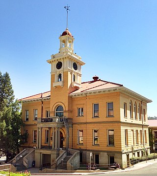
Sonora is the county seat of Tuolumne County, California, United States. Founded during the California Gold Rush by Mexican miners from Sonora, the city population was 4,994 during the 2020 Census, an increase of 91 from the 4,903 counted during the 2010 Census.

<span class="mw-page-title-main">Tuolumne City, California</span> Census-designated place in California, United States

Tuolumne City is an unincorporated town in Tuolumne County, California. A census-designated place (CDP) officially known as Tuolumne also encompasses the town. The population of the CDP was 1,779 at the 2010 census, down from 1,865 at the 2000 census.

<span class="mw-page-title-main">Twain Harte, California</span> Census-designated place in California, United States

Twain Harte is a census-designated place (CDP) in Tuolumne County, California, United States. The population was 2,226 at the 2010 census, down from 2,586 at the 2000 census. Its name is derived from the last names of two famous authors who lived in California, Mark Twain and Bret Harte.

<span class="mw-page-title-main">Matherville, Illinois</span> Village in Illinois, United States

Matherville is a village in Mercer County, Illinois, United States. The population was 707 at the 2020 census.

<span class="mw-page-title-main">Middletown, Iowa</span> City in Iowa, United States

Middletown is a city in Des Moines County, Iowa, United States. The population was 363 at the time of the 2020 census. It is part of the Burlington, IA–IL Micropolitan Statistical Area.

<span class="mw-page-title-main">Lakewood Club, Michigan</span> Village in Michigan, United States

Lakewood Club is a village in Dalton Township of Muskegon County in the U.S. state of Michigan. The population was 1,291 at the 2010 census.

<span class="mw-page-title-main">Deepwater, Missouri</span> City in Missouri, United States

Deepwater is a city in Henry County, Missouri, United States. The population was 433 at the 2010 census.

<span class="mw-page-title-main">Twin Valley, Minnesota</span> City in Minnesota, United States

Twin Valley is a city in Norman County, Minnesota, United States, along the Wild Rice River. The population was 723 at the 2020 census.

<span class="mw-page-title-main">Concord Township, Butler County, Pennsylvania</span> Township in Pennsylvania, United States

Concord Township is a township in Butler County, Pennsylvania, United States. The population was 1,411 at the 2020 census.

<span class="mw-page-title-main">Gastonville, Pennsylvania</span> Census-designated place in Pennsylvania, United States

Gastonville is a census-designated place (CDP) in Washington County, Pennsylvania, United States. The population was 2,818 at the 2010 census.

<span class="mw-page-title-main">Marvin, South Dakota</span> Town in South Dakota, United States

Marvin is a town in Grant County, South Dakota, United States. The population was 19 at the 2020 census.

<span class="mw-page-title-main">Tuttletown, California</span> Census-designated place in California, United States

Tuttletown is a census-designated place (CDP) in Tuolumne County, California. It is located on State Route 49 near the gold rush community of Columbia. Tuttletown sits at an elevation of 1,047 feet (319 m). The 2010 United States census reported Tuttletown's population was 668.

Strawberry is an unincorporated community and a census-designated place (CDP) in Tuolumne County, California. Strawberry is located on California State Route 108 10 miles (16 km) northeast of Long Barn. Strawberry has a post office with ZIP code 95375, which opened in 1949. Strawberry sits at an elevation of 5,325 feet (1,623 m). The 2010 United States census reported Strawberry's population was 125.

References

  1. "2010 Census Gazetteer Files - Places - California". United States Census Bureau . Retrieved March 26, 2015.
  2. 1 2 "Soulsbyville". Office of Historic Preservation, California State Parks. Retrieved October 18, 2012.
  3. "US Gazetteer files: 2010, 2000, and 1990". United States Census Bureau. February 12, 2011. Retrieved April 23, 2011.
  4. "2010 Census Interactive Population Search: CA - Soulsbyville CDP". U.S. Census Bureau. Archived from the original on July 15, 2014. Retrieved July 12, 2014.
  5. "U.S. Census website". United States Census Bureau . Retrieved January 31, 2008.
  6. "Soulsbyville - Soulsbyville, CA - E Clampus Vitus Historical Markers on Waymarking.com". www.waymarking.com. Retrieved June 14, 2020.
  7. "Statewide Database". Regents of the University of California . Retrieved March 26, 2015.
  8. "California's 4th Congressional District - Representatives & District Map". Civic Impulse, LLC. Retrieved September 28, 2014.
  9. California Parks, California Historical Landmark
  10. californiahistoricallandmarks.com Landmarks chl-420