Mid Bedfordshire District

Last updated

Mid Bedfordshire
BedfordshireMid.png
Shown within Bedfordshire non-metropolitan county
Area
  1974124,423 acres (503.52 km2) [1]
Population
  197394,750 [1]
  1992110,110 [2]
  2007118,200
History
  Created1974
  Abolished2009
  Succeeded by Central Bedfordshire
StatusNon-metropolitan district
ONS code09UC
GovernmentMid Bedfordshire District Council
Mid Beds logo.png
Subdivisions
  Type Civil parishes

Mid Bedfordshire was a local government district in Bedfordshire, England, from 1974 to 2009.

Contents

Creation

The district was formed on 1 April 1974 as part of a general reorganisation of local authorities in England and Wales carried out under the Local Government Act 1972. Mid Bedfordshire was formed by the amalgamation of five districts: [1]

The new council continued to use the former offices of Ampthill Rural District Council and Biggleswade Rural District Council until 2006, when a new combined office was built at Priory House, Chicksands for £15 million. [3] [4]

Civil parishes

Former offices of Mid Bedfordshire District Council at 12 Dunstable Street, Ampthill 12 Dunstable Street, Ampthill (October 2023).jpg
Former offices of Mid Bedfordshire District Council at 12 Dunstable Street, Ampthill

The district comprised the following civil parishes: [5]

Elections and political control

The first election to Mid Bedfordshire District Council took place on 7 June 1973, with the 49 councillors elected forming a shadow authority until 1 April 1974. [1] Following ward boundary changes, the number of councillors was increased to 53 in 1979. [6] Elections for the whole council were then held in 1979 and every four years thereafter. In 2003 the wards were again redrawn, with the size of the council remaining at 53. [5] The final election took place in 2007, with councillors staying in office until the abolition of the council in 2009.

The first council elected had a large majority of independent councillors. [7] Gains by the Conservatives in 1976 meant that the council was under no control, although independents remained the largest group. [8] In 1979 Conservatives gained a majority, which they held for sixteen years. [9] In 1995 there was a large swing against the unpopular government of John Major, and the Labour Party gained 17 seats to achieve parity with the Conservatives. The council also included Liberal Democrats and Independents. [10] In 1999 the Conservatives regained control, which they held until the council's abolition. [11]

YearConservativeLabourLiberal/
Liberal Democrat
IndependentGreen PartyControl
1973 [7] 1713870Independent
1976 [8] 1931260No overall control
1979 [9] 3610630Conservative gain from NOC
1983 [12] 2670200Conservative hold
1987 [13] 422360Conservative hold
1991 [14] 403370Conservative hold
1995 [10] 2121560No overall control
1999 [11] 347660Conservative gain from NOC
2003 [15] 381950Conservative hold
2007 [16] 3801131Conservative hold

† New ward boundaries

Abolition

In 2006 the Department for Communities and Local Government considered reorganising Bedfordshire's administrative structure as part of the 2009 structural changes to local government in England. On 6 March 2008 it was announced that Mid Bedfordshire would merge with the neighbouring district of South Bedfordshire to form a new unitary authority called Central Bedfordshire. The new council was formed on 1 April 2009 although its initial members were not elected until 4 June 2009. [17]

Related Research Articles

<span class="mw-page-title-main">South Bedfordshire</span> Former local government district in England

South Bedfordshire was a local government district in Bedfordshire, in the East of England, from 1974 to 2009. Its main towns were Dunstable, Houghton Regis and Leighton Buzzard.

Salisbury was a local government district in Wiltshire, England from 1974 to 2009. Its main urban area was the city of Salisbury.

<span class="mw-page-title-main">Old Warden</span> Human settlement in England

Old Warden is a village and civil parish in the Central Bedfordshire district of the county of Bedfordshire, England, about 6.5 miles (10 km) south-east of the county town of Bedford.

<span class="mw-page-title-main">History of Bedfordshire</span> History of Bedfordshire County in England

Bedfordshire is an English ceremonial county which lies between approximately 25 miles and 55 miles north of central London.

<span class="mw-page-title-main">Civil parishes in Bedfordshire</span> List of places

A civil parish is a country subdivision, forming the lowest unit of local government in England. There are 125 civil parishes in the ceremonial county of Bedfordshire, most of the county being parished: Luton is completely unparished; Central Bedfordshire is entirely parished. At the 2001 census, there were 312,301 people living in the 125 parishes, which accounted for 55.2 per cent of the county's population.

<span class="mw-page-title-main">Mid Bedfordshire (UK Parliament constituency)</span> Parliamentary constituency in the United Kingdom, 1918 onwards

Mid Bedfordshire is a constituency represented in the House of Commons of the UK Parliament by Alistair Strathern of the Labour Party since a 2023 by-election.

<span class="mw-page-title-main">Bedford Borough Council</span>

Bedford Borough Council is the local authority of the Borough of Bedford in Bedfordshire, England. It is a unitary authority, having the powers of a non-metropolitan county and district council combined. The executive of the council is the directly elected mayor of Bedford. It is a member of the East of England Local Government Association.

<span class="mw-page-title-main">Broom, Bedfordshire</span> Human settlement in England

Broom is a small village in the Central Bedfordshire district of the county of Bedfordshire, England about 8.5 miles (14 km) south-east of the county town of Bedford.

<span class="mw-page-title-main">Chicksands</span> Human settlement in England

Chicksands is a village and former civil parish, now in the parish of Campton and Chicksands in the Central Bedfordshire district of Bedfordshire, England. The village is on the River Flit and close to its parish village of Campton and the town of Shefford.

Biggleswade was a rural district in Bedfordshire, England from 1894 to 1974. As initially created the district entirely surrounded but did not include Biggleswade, which was an urban district in its own right. In 1927 the parish of Sandy, which bordered Biggleswade, also became an urban district, leaving an island of two urban districts surrounded by the rural district.

<span class="mw-page-title-main">Northill</span> Human settlement in England

Northill is a village and civil parish in the Central Bedfordshire district of the county of Bedfordshire, England about 6.5 miles (10 km) southeast of the county town of Bedford.

<span class="mw-page-title-main">Stanford, Bedfordshire</span> Human settlement in England

Stanford is a hamlet in the civil parish of Southill, in the Central Bedfordshire district of the ceremonial county of Bedfordshire, England. It is about 8.5 miles (14 km) south-east of the county town of Bedford. In 1870–72 it had a population of 385.

<span class="mw-page-title-main">1997 United Kingdom local elections</span>

The 1997 United Kingdom local elections took place on Thursday 1 May 1997 in England, and Wednesday 21 May 1997 in Northern Ireland. Elections took place for all of the English country councils, some English unitary authorities and all of the Northern Ireland districts. The local elections were held on the same day as the 1997 general election.

<span class="mw-page-title-main">Central Bedfordshire</span> District in England

Central Bedfordshire is a unitary authority area in the ceremonial county of Bedfordshire, England. It was created in 2009.

<span class="mw-page-title-main">Central Bedfordshire Council</span>

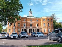
Central Bedfordshire Council is the local authority for the Central Bedfordshire unitary authority area in the ceremonial county of Bedfordshire, England. It was created in 2009 covering the area of the former Mid Bedfordshire and South Bedfordshire districts, and also took over the functions of the abolished Bedfordshire County Council in that area. The council is based at Chicksands.

<span class="mw-page-title-main">2011 Central Bedfordshire Council election</span>

The 2011 Central Bedfordshire Council electionfor the Central Bedfordshire Council were held on 5 May 2011, along with other United Kingdom local elections. The whole council was up for election following boundary changes, with each successful candidate serving a four-year term of office, expiring in 2015.

The first election to Mid Bedfordshire District Council was held on 7 June 1973, with the 49 councillors elected forming a shadow authority until 1 April 1974. Mid Bedfordshire District was formed on 1 April 1974 as part of a general reorganisation of local authorities in England and Wales carried out under the Local Government Act 1972. The district was formed by the amalgamation of five districts:

<span class="mw-page-title-main">Dorset Council (UK)</span> Local authority in England

Dorset Council is a unitary local authority for the district of Dorset, encompassing almost all of the county of the same name (Dorset) except for the district of Bournemouth, Christchurch and Poole. Created in April 2019, the council was formed when the county moved from a two-tier county council and district council system to a one-tier system, with the county divided into two districts administered by two independent unitary authorities.

The town of Ampthill in Bedfordshire, England was administered as a Local Government District from 1893 to 1894 and an Urban District from 1894 to 1974.

References

  1. 1 2 3 4 Local government in England and Wales: A Guide to the New System. London: HMSO. 1974. p. 30. ISBN   0117508470.
  2. OPCS Key Population and Statistics 1992
  3. Priory House, Chicksands, Bedfordshire Archives, retrieved 6 August 2021
  4. "Moving story". The Comet. Archant. 20 July 2006. Retrieved 2 April 2022. The building opens to the public on Monday, August 7.
  5. 1 2 "The District of Mid Bedfordshire (Electoral Changes) Order 2001". Office of Public Sector Information. 2001. Retrieved 17 March 2009.
  6. "District level Authority Results.xlsx", www.electionscentre.co.uk, The Elections Centre, Plymouth University, retrieved 15 May 2017
  7. 1 2 "Final poll result may lie with Independents". The Times . 8 June 1973.
  8. 1 2 "Heavy Labour losses in district polls". The Times . 8 May 1976.
  9. 1 2 Whitaker's Almanack 1980. London: Joseph Whitaker. 1980. ISBN   085021114X.
  10. 1 2 "Complete list of results from Thursday's council elections". The Times . 6 May 1995. p. 10.
  11. 1 2 "How Britain voted: Council Election Results". The Independent . 8 May 1999. p. 12.
  12. "How votes were cast in local government elections". The Times . 7 May 1983. p. 4.
  13. "Results in Thursday's local elections". The Times . 9 May 1987.
  14. "Complete round-up of results from Thursday's local council elections". The Times . 4 May 1991.
  15. "English councils: Non-metropolitan districts". The Times . 3 May 2003. p. 47.
  16. "Results: Election 2007". The Times . 5 May 2007. p. 83.
  17. "Unitary solution confirmed for Bedfordshire – New flagship unitary councils approved for Cheshire", www.communities.gov.uk, Department for Communities and Local Government, 22 November 2008, archived from the original on 22 November 2008

52°08′09″N0°28′05″W / 52.13583°N 0.46806°W / 52.13583; -0.46806