
Flitwick is a town and civil parish in Central Bedfordshire, England. It is mentioned in the Domesday Book of 1086 as "a hamlet on the River Flitt". The spelling Flytwyk appears in 1381.

Linslade is a town in the civil parish of Leighton-Linslade, in the Central Bedfordshire unitary authority area of Bedfordshire, England. It borders the town of Leighton Buzzard. Linslade was transferred from Buckinghamshire in 1965. Before then, it was a separate urban district. It remained a part of the Diocese of Oxford until 2008 when it joined Leighton Buzzard in the Diocese of St Albans.
Bromham is a village and civil parish in the Borough of Bedford in Bedfordshire, England, situated around 3 miles (4.8 km) west of Bedford town centre.

Aspley Guise is a village and civil parish in the west of Central Bedfordshire, England. In addition to the village of Aspley Guise itself, the civil parish also includes part of the town of Woburn Sands, the rest of which is in the City of Milton Keynes in Buckinghamshire. Together with Woburn Sands and Aspley Heath, it forms part of the Milton Keynes urban area. It is centred 6 miles (9.7 km) east southeast of Central Milton Keynes and 1 mile (1.6 km) south of the M1 junction 13. It has its own railway station on the Marston Vale Line, and an historic centre with 29 listed buildings.

Harlington is a village and civil parish located in Bedfordshire, England, near the M1 motorway. The nearest town is Flitwick about 3 miles (4.8 km) to the north.

Turvey is a village and civil parish on the River Great Ouse in the Borough of Bedford, Bedfordshire, England, about 7 miles (11 km) west of Bedford town centre. The village is on the A428 road between Bedford and Northampton, close to the border with Buckinghamshire. The 2011 Census recorded the parish's population as 1,225.

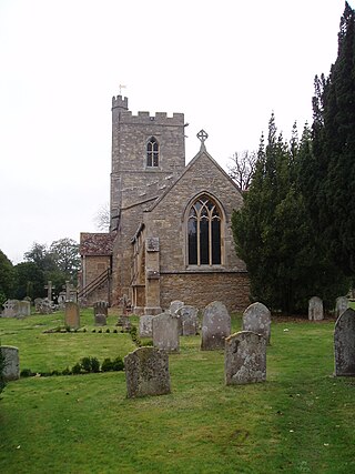
Houghton Regis is a market town and civil parish in the Central Bedfordshire district of Bedfordshire, England.

Milton Ernest is a village and civil parish in Bedfordshire, England, about 5 miles (8.0 km) north of Bedford itself. It had a population of 754 in 2001. This had risen to 761 according to the 2011 census. The village is situated on the east bank of the River Great Ouse, and is the site of Milton Ernest Hall, which was used as the United States Eighth Air Force's support command headquarters in the Second World War.

Caddington is a village and civil parish in the Central Bedfordshire district of Bedfordshire, England.

Barton-le-Clay is a large village and a civil parish in the Central Bedfordshire district of Bedfordshire, England, bordering Hertfordshire. The village has existed since at least 1066 and is mentioned in the Domesday Book.

Silsoe is a village and civil parish in Bedfordshire, England. The village used to be on the main A6 road but a bypass around the village was opened in 1981 at a cost of £1.6m.
Little Witley is a village and civil parish in the Malvern Hills District in the county of Worcestershire, England.

Cople is a village and civil parish in the English county of Bedfordshire. The name Cople is derived from the phrase Cock Pool, a place where chickens were kept, that was mentioned in the Domesday Book.
Riseley is a village and civil parish located in North Bedfordshire, England. The village name has had alternative spellings in the past such as Rislau, Riseleg, Riselai and Risely, however all these spellings are considered archaic. It has a population of 1,284 according to the 2001 census, increasing to 1,286 at the 2011 Census, and is near the villages of Bletsoe, Sharnbrook, Swineshead, Pertenhall, Keysoe, Thurleigh and Melchbourne. The nearest town to Riseley is Rushden in the neighbouring county of Northamptonshire, approximately 8 miles away to the north west. The county town of Bedford is approximately 9 miles to the South of Riseley. The village has one watercourse, which is a tributary of the River Ouse, flowing through it known locally as the 'Brook' around which in medieval times the village was built.

Upper Sundon is a village located in the Central Bedfordshire district of Bedfordshire, England.

Sisland, historically Sislanda, is a very small village, manor and parish in the county of Norfolk, England, about a mile west of Loddon. In the 2001 census, the population was 44 in 16 households. The parish covers an area of 1.90 km2 (0.73 sq mi), and is approximately 9.3 miles (15.0 km) southeast of Norwich and 12.7 miles (20.4 km) west of Great Yarmouth. For the purposes of local government, it falls within the district of South Norfolk, however Sisland does have its own Parish Council. The village contains only one heritage-listed building, that being St Mary's Church, which is Grade II*.

Wrestlingworth is a village and former civil parish, now in the parish of Wrestlingworth and Cockayne Hatley, in the Central Bedfordshire district of the ceremonial county of Bedfordshire, England about 13 miles (21 km) east of the county town of Bedford. The 2011 census gives the population of the village proper as 591. The hamlet of Water End is to the south of the village. The population of Wrestlingworth and Cockayne Hatley civil parish in the 2011 census is shown as 744.

Husborne Crawley is a small village and civil parish in Bedfordshire, England, located close to Junction 13 of the M1 motorway. The village touches the borders of the Woburn Abbey estate on one side, and the village of Aspley Guise on the other. The meaning of the Husborne element of the towns name is "warrior stream" and the Crawley element means "crow clearing". It appears as Hussheburn Crawele, in 1421.
Southill is a rural village and civil parish in the Central Bedfordshire district of the county of Bedfordshire, England; about 8 miles (13 km) south-east of the county town of Bedford.

The Church of All Saints, Houghton Regis, Bedfordshire, is a medieval Grade I listed building. Characterised by flint and clunch checker work on the exterior, the church dates predominantly from the 13th and 14th centuries, with 15th century additions. All Saints' serves as the Parish Church for Houghton Regis, the parish including the town, parts of North Dunstable, Bidwell West, Thorn, and Linmere, as well as the hamlet of Sewell.

