
Luton is a town, borough and unitary authority situated in Bedfordshire, south east England, but in the East of England region for administrative purposes. It has a population of 213,052 (mid-2019 est.) and is one of the most populous towns without city status in the United Kingdom. It is also the most populous town in Bedfordshire. The town is situated on the River Lea, about 30 miles (50 km) north-northwest of London. The town's foundation dates to the sixth century as a Saxon outpost on the River Lea, from which Luton derives its name. Luton is recorded in the Domesday Book as Loitone and Lintone and one of the largest churches in Bedfordshire, St Mary's Church, was built in the 12th century. There are local museums which explore Luton's history in Wardown Park and Stockwood Park.

Bedfordshire is a ceremonial county in the East of England. The county is adminstered by three unitary authorities: Borough of Bedford, Central Bedfordshire, and Borough of Luton, after the county council was abolished in 2009
Hanging Houghton is a small village in West Northamptonshire in England. It is on the A508 road between Brixworth and Lamport, in the civil parish of Lamport.

Toddington is a large village and civil parish in the county of Bedfordshire, England. It is situated 5 miles north-north-west of Luton, 4 miles (6 km) north of Dunstable, 6 miles (10 km) south-west of Woburn, and 35 miles north-north-west of London on the B5120 and B579. It is 0.5 miles from Junction 12 of the M1 motorway and lends its name to the nearby motorway service station. The hamlet of Fancott also forms part of the Toddington civil parish.

Houghton Regis is an industrial town and civil parish in Bedfordshire, East of England.

Caddington is a village and civil parish in the Central Bedfordshire district of Bedfordshire, England. It is between the Luton/Dunstable urban area, and Hertfordshire.

Chalgrave is a civil parish in the Central Bedfordshire district of Bedfordshire, England. The hamlets of Tebworth and Wingfield are in the west of the parish, with the church and manor in the east. Nearby places are Toddington, Chalton, Houghton Regis, and Hockliffe. Before 1929, the parish also included part of the village of Hockliffe.
Lewsey is a suburb of Luton, England. Situated in the north-west of the town, the area is roughly bounded by Leagrave High Street to the north, Dunstable Road to the south, Poynters Road to the west, and the M1 to the east.
Bidwell is a hamlet located next to Houghton Regis in Bedfordshire, England.

Totternhoe is a village and civil parish in the Manshead hundred of the county of Bedfordshire, England.
This article is about the History of Luton, a large town located in the south of Bedfordshire, England.

The Leighton Buzzard Light Railway (LBLR) is a light railway in Leighton Buzzard in Bedfordshire, England. It operates on 2 ft narrow-gauge track and is just under 3 miles (4.8 km) long. The line was built after the First World War to serve sand quarries north of the town. In the late 1960s the quarries switched to road transport and the railway was taken over by volunteers, who now run the line as a heritage railway.

Dunstable is a market town and civil parish in Bedfordshire, England, east of the Chiltern Hills, 30 miles north of London. There are several steep chalk escarpments, most noticeable when approaching Dunstable from the north. Dunstable is the third largest town in Bedfordshire and along with Houghton Regis forms the westernmost part of the Luton/Dunstable Urban Area.
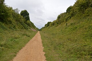
Sewell Cutting is a 3.6 hectare nature reserve at Sewell in Houghton Regis in Bedfordshire. It is owned by Central Bedfordshire Council and managed by the Wildlife Trust for Bedfordshire, Cambridgeshire and Northamptonshire.

Slaughterbridge, Treague and Camelford Station are three adjoining settlements in north Cornwall, England. They straddle the boundary of Forrabury and Minster and Lanteglos by Camelford civil parishes just over a mile (2 km) north-west of the market town of Camelford.
Lower Caldecote is a hamlet in the civil parish of Northill and part of the Central Bedfordshire district of Bedfordshire, England. The county town of Bedford is 7.5 miles (12 km) to the west.
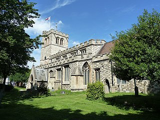
The Church of All Saints formerly The Church of St. Michael is a Church of England parish church in Houghton Regis in the English county of Bedfordshire. It is a Grade I listed building.
Maiden Bower is an Iron Age hillfort near Dunstable in Bedfordshire, England. The site, which also has traces of a Neolithic causewayed enclosure, is a scheduled monument.
