
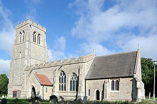
Campton is a village and former civil parish, now in the parish of Campton and Chicksands, in the Central Bedfordshire district of Bedfordshire, England. It is about 9 miles (14 km) south of Bedford, and is about 9 miles (14 km) north-west from Letchworth and sits on a tributary of the River Ivel. It is just to the west of Shefford. The 13th century Church of All Saints is in the centre of the village. In 1961 the parish had a population of 358.

Wootton is a large village and civil parish located to the south-west of Bedford, in the north of Bedfordshire, England. The parish also includes the hamlets of Hall End, Keeley Green and Wootton Green.
Bolnhurst is a small village and former civil parish, now in the parish of Bolnhurst and Keysoe, in the Borough of Bedford, Bedfordshire, England. The village is about 6 miles (9.7 km) north-northeast of Bedford town centre and about 6 miles (10 km) west of St Neots. In 1931 the parish had a population of 162.

Chicksands is a village and former civil parish, now in the parish of Campton and Chicksands in the Central Bedfordshire district of Bedfordshire, England. The village is on the River Flit and close to its parish village of Campton and the town of Shefford.

Carlton is a village and former civil parish, now in the parish of Carlton and Chellington, in the Bedford district, in the ceremonial county of Bedfordshire, England. The River Great Ouse runs just to the north of the village. Nearby places are Chellington, Harrold, Pavenham, Turvey, Lavendon and Odell. In 1931 the parish had a population of 340.

Ampthill was a rural district in Bedfordshire, England from 1894 to 1974. It entirely surrounded but did not include the urban district of Ampthill.

Souldrop is a village and former civil parish, now in the parish of Knotting and Souldrop, in the Bedford district, in the ceremonial county of Bedfordshire, England, located near the border with Northamptonshire. Nearby places are, Sharnbrook, Podington, Odell, Melchbourne, Yelden, Knotting, and Newton Bromswold and Rushden over the border in Northamptonshire. In 1931 the parish had a population of 161. On 1 April 1934 the parish was abolished and merged with Knotting to form "Knotting and Souldrop".

Chellington is a village and former civil parish, now in the parish of Carlton and Chellington, in the Bedford district, in the ceremonial county of Bedfordshire, England, situated approximately 7 miles (11 km) north-west of Bedford town centre. In 1931 the parish had a population of 78.

Dean or Over Dene is a former civil parish, now in the parish of Dean and Shelton, in the Bedford district, in the ceremonial county of Bedfordshire, England. It contained Lower Dean and Upper Dean. In 1931 the parish had a population of 277.

Higham Gobion is a village and former civil parish, now in the parish of Shillington, in the Central Bedfordshire district, in the ceremonial county of Bedfordshire, England. It is located between the villages of Shillington and Barton-le-Clay. In 1961 the parish had a population of 28. On 1 April 1984 the parish was abolished and merged with Shillington. It was in the hundred of Flitt.

Husborne Crawley is a small village and civil parish in Bedfordshire, England, located close to Junction 13 of the M1 motorway. The village touches the borders of the Woburn Abbey estate on one side, and the village of Aspley Guise on the other. The meaning of the Husborne element of the towns name is "warrior stream" and the Crawley element means "crow clearing". It appears as Hussheburn Crawele, in 1421.

Goldington is an area of Bedford and electoral ward in the unparished area of Bedford, in the Bedford district, in the ceremonial county of Bedfordshire, England. It encompasses much of the historic village and parish of Goldington that was merged with Bedford in 1934, although some parts of the old village are within the neighbouring Newnham ward. It also includes two modern estates that are part of Renhold parish.

Knotting is a village and former civil parish, now in the parish of Knotting and Souldrop, in the Bedford district, in the ceremonial county of Bedfordshire, located near the border with Northamptonshire. Nearby places are, Sharnbrook, Podington, Odell, Melchbourne, Yelden, Newton Bromswold, Souldrop and Rushden over the border in Northamptonshire. In 1931 the parish had a population of 114. On 1 April 1934 the parish was abolished to form "Knotting and Souldrop".

Ousden is a village and civil parish in the West Suffolk district of Suffolk in eastern England. It is located around six miles west of Bury St Edmunds and 72 miles north of London, and as of 2011, its population is 266. The village has an Anglican church of St Peter's and a chapel in the cemetery dedicated to St Barnabas.

Upper Gravenhurst is a village and former civil parish, now in the parish of Gravenhurst, in the Central Bedfordshire district of the ceremonial county of Bedfordshire, England. In 1881 the parish had a population of 354. On 24 March 1888 the parish was abolished and merged with Lower Gravenhurst to form "Gravenhurst".

Salford is a village and former civil parish, now in the parish of Hulcote and Salford, in the Central Bedfordshire district, in the ceremonial county of Bedfordshire, England. It is located near the large new town of Milton Keynes and the M1 motorway. In 1931 the parish had a population of 133. On 1 April 1933, the parish was merged with Hulcote to form "Hulcote and Salford".
Keysoe is a village and former civil parish, now in the parish of Bolnhurst and Keysoe, in the Bedford district, in the ceremonial county of Bedfordshire, England. In 1931 the parish had a population of 432. On 1 April 1934 the parish was abolished to form "Bolnhurst and Keysoe".

Melchbourne is a village and former civil parish, now in the parish of Melchbourne and Yielden, in the Bedford district, in the ceremonial county of Bedfordshire, England. In 1931 the parish had a population of 160. On 1 April 1934 the parish was abolished to form "Melchbourne and Yelden".

Shelton is a village and former civil parish, now in the parish of Dean and Shelton, in the Bedford district, in the ceremonial county of Bedfordshire, England. In 1931 the parish had a population of 101. On 1 April 1934 the parish was abolished and merged with Dean to form "Dean and Shelton".

Thurleigh is a village and civil parish in the Borough of Bedford, north Bedfordshire, England, situated around 5 miles (8.0 km) north of Bedford town centre.

