Mirrormont, Washington

Last updated
Mirrormont, Washington
King County Washington Incorporated and Unincorporated areas Mirrormont Highlighted.svg
Location of Mirrormont, Washington
Coordinates: 47°28′4″N122°0′33″W / 47.46778°N 122.00917°W / 47.46778; -122.00917 Coordinates: 47°28′4″N122°0′33″W / 47.46778°N 122.00917°W / 47.46778; -122.00917
CountryUnited States
State Washington
County King
Area
  Total10.41 sq mi (26.97 km2)
  Land10.37 sq mi (26.86 km2)
  Water0.04 sq mi (0.11 km2)
Elevation
700 ft (200 m)
Population
 (2020) [1]
  Total3,858
  Density353/sq mi (136.2/km2)
Time zone UTC-8 (Pacific (PST))
  Summer (DST) UTC-7 (PDT)
FIPS code 53-46215 [2]
GNIS feature ID1867621 [3]

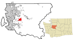
Mirrormont is a census-designated place (CDP) in King County, Washington, United States, south of Issaquah. The population was 3,858 at the 2020 census. [1] Within the last decade, the area has seen a shift in development as larger homes have been constructed in Cedar Grove, the Highlands at Tiger Mountain and Mirrormont.

Contents

Geography

Mirrormont is located in central King County at 47°28′4″N122°0′33″W / 47.46778°N 122.00917°W / 47.46778; -122.00917 (47.467871, -122.009209). [4] It is bordered to the west by East Renton Highlands and to the south by Hobart. Part of Tiger Mountain occupies the northeast portion of the CDP. Washington State Route 18 runs along the southeast edge of the CDP, leading northeast 6 miles (10 km) to Interstate 90 near Snoqualmie and southwest 17 miles (27 km) to Auburn.

According to the United States Census Bureau, the Mirrormont CDP has a total area of 10.4 square miles (27.0 km2), of which 10.4 square miles (26.9 km2) are land and 0.04 square miles (0.1 km2), or 0.42%, are water.

Demographics

Historical population
CensusPop.
1990 2,360
2000 3,80461.2%
2010 3,659−3.8%
2020 3,8585.4%
U.S. Decennial Census [5]
2020 Census [1]

As of the census [2] of 2000, there were 3,804 people, 1,330 households, and 1,110 families residing in the CDP. The population density was 367.3 people per square mile (141.8/km2). There were 1,365 housing units at an average density of 131.8/sq mi (50.9/km2). The racial makeup of the CDP was 94.03% White, 0.45% African American, 0.58% Native American, 1.37% Asian, 0.13% Pacific Islander, 0.81% from other races, and 2.63% from two or more races. Hispanic or Latino of any race were 1.68% of the population.

There were 1,330 households, out of which 39.4% had children under the age of 18 living with them, 76.6% were married couples living together, 4.0% had a female householder with no husband present, and 16.5% were non-families. 12.2% of all households were made up of individuals, and 2.7% had someone living alone who was 65 years of age or older. The average household size was 2.81 and the average family size was 3.05.

In the CDP the population was spread out, with 26.9% under the age of 18, 4.8% from 18 to 24, 27.9% from 25 to 44, 32.5% from 45 to 64, and 7.8% who were 65 years of age or older. The median age was 41 years. For every 100 females there were 103.7 males. For every 100 females age 18 and over, there were 100.8 males.

The median income for a household in the CDP was $87,945, and the median income for a family was $90,413. Males had a median income of $70,365 versus $38,929 for females. The per capita income for the CDP was $35,200. About 3.1% of families and 5.7% of the population were below the poverty line, including 6.3% of those under age 18 and 4.5% of those age 65 or over.

Schools

District: Issaquah School District 411 (which includes the majority of Mirrormont) [6]

Schools: Maple Hills Elementary, Maywood Middle School, Liberty Senior High School

A portion of Mirrormont is in the Tahoma School District. [6]

Related Research Articles

Three Oaks, Florida Census-designated place in Florida, United States

Three Oaks is a census-designated place (CDP) in Lee County, Florida, United States. The population was 3,592 at the 2010 census, up from 2,255 at the 2000 census. It is part of the Cape Coral-Fort Myers, Florida Metropolitan Statistical Area.

Northwest Ithaca is a census-designated place (CDP) in Tompkins County, New York, United States. The population was 1,115 at the 2000 census.

Ames Lake, Washington Census-designated place in Washington, United States

Ames Lake is an unincorporated community and census-designated place (CDP) in King County, Washington, United States. The population was 1,486 at the 2010 census.

East Renton Highlands, Washington Census-designated place in Washington, United States

East Renton Highlands is a census-designated place (CDP) in King County, Washington, United States, located between Issaquah and Renton. The population was 11,937 at the 2020 census.

Hobart, Washington Census-designated place in Washington, United States

Hobart is an unincorporated community and census-designated place (CDP) in King County, Washington, United States. The population was 6,221 at the 2010 census.

Lake Morton-Berrydale, Washington Census-designated place in Washington, United States

Lake Morton-Berrydale is a census-designated place (CDP) in King County, Washington, United States. The population was 10,474 at the 2020 census.

Lakeland North, Washington Census-designated place in Washington, United States

Lakeland North is a census-designated place (CDP) in King County, Washington, United States. The population was 12,942 at the 2010 census. Part of the community was annexed into neighboring Auburn in 2008.

Lakeland South, Washington Census-designated place in Washington, United States

Lakeland South is a census-designated place (CDP) in King County, Washington, United States. The population was 11,574 at the 2010 census.

Union Hill-Novelty Hill, Washington Census-designated place in Washington, United States

Union Hill-Novelty Hill is a census-designated place (CDP) in King County, Washington, United States. The area was first recognized by the Census Bureau in the 2000 census. The population was 18,805 at the 2010 census.

Suquamish, Washington Census-designated place in Washington, United States

Suquamish is a census-designated place (CDP) in Kitsap County, Washington, United States. The population was 4,140 at the 2010 census. Comprising the Port Madison Indian Reservation, it is the burial site of Chief Seattle and the site of the Suquamish tribe winter longhouse known as Old Man House.

Tracyton, Washington Census-designated place in Washington, United States

Tracyton is a census-designated place (CDP) in Kitsap County, Washington, United States. Its population was 5,233 at the 2010 census. It was named for 19th century Secretary of the Navy Benjamin F. Tracy.

Elk Plain, Washington CDP in Washington, United States

Elk Plain is a census-designated place (CDP) in Pierce County, Washington, United States. The population was 14,205 at the 2010 census.

Frederickson, Washington CDP in Washington, United States

Frederickson is a census-designated place (CDP) in Pierce County, Washington, United States. The population was 24,906 at the 2020 census.

Prairie Ridge, Washington CDP in Washington, United States

Prairie Ridge is a census-designated place (CDP) in Pierce County, Washington, United States. The population was 12,288 at the 2020 census.

Waller, Washington CDP in Washington, United States

Waller is a census-designated place (CDP) in Pierce County, Washington, United States. The population was 9,200 at the 2000 census.

High Bridge, Washington CDP in Washington, United States

High Bridge is a census-designated place (CDP) in Snohomish County, Washington, United States. The population was 2,994 at the 2010 census. High Bridge includes the Echo Lake community and the former Echo Lake CDP, which was superseded by the larger High Bridge CDP in 2010.

Martha Lake, Washington CDP in Washington, United States

Martha Lake is a census-designated place (CDP) in Snohomish County, Washington, United States. The population was 21,129 at the 2020 census. It lies west of Mill Creek and northeast of Lynnwood, near the lake of the same name.

Lake Stickney, Washington CDP in Washington, United States

Lake Stickney is a census-designated place (CDP) in Snohomish County, Washington, United States. The population was 7,777 at the 2010 census. The CDP was known as Paine Field-Lake Stickney prior to 2010. The new Lake Stickney CDP no longer contains the Paine Field airport.

Silver Firs, Washington CDP in Washington, United States

Silver Firs is a census-designated place (CDP) in Snohomish County, Washington, United States. The population was 20,891 at the 2010 census. It lies northeast of the city of Mill Creek. Silver Firs is one of two CDPs that were created out of the former Seattle Hill-Silver Firs CDP in 2010, the other being Eastmont.

Bangor Base, Washington Census-designated place in Washington, United States

Bangor Base is a census-designated place (CDP) in Kitsap County, Washington, within U.S. Naval Base Kitsap on the Kitsap Peninsula. Its population was 6,054 at the 2010 census.

References

  1. 1 2 3 "2020 Census Redistricting Data (Public Law 94-171) Summary File". American FactFinder. United States Census Bureau . Retrieved May 13, 2022.
  2. 1 2 "U.S. Census website". United States Census Bureau . Retrieved January 31, 2008.
  3. "Mirrormont". Geographic Names Information System . United States Geological Survey.
  4. "US Gazetteer files: 2010, 2000, and 1990". United States Census Bureau. February 12, 2011. Retrieved April 23, 2011.
  5. "Census of Population and Housing". Census.gov. Retrieved June 4, 2016.
  6. 1 2 U.S. Census Bureau Geography Division (December 21, 2020). 2020 Census – School District Reference Map: King County, WA (PDF) (Map). 1:80,000. U.S. Census Bureau. p. 2. Retrieved August 3, 2022.