White Center, Washington

Last updated

White Center, Washington
White Center - Delridge.jpg
King County Washington Incorporated and Unincorporated areas White Center Highlighted.svg
Location of White Center, Washington
Coordinates: 47°30′27″N122°20′51″W / 47.50750°N 122.34750°W / 47.50750; -122.34750
CountryUnited States
State Washington
County King
Area
[1]
  Total2.25 sq mi (5.83 km2)
  Land2.24 sq mi (5.81 km2)
  Water0.008 sq mi (0.02 km2)
Elevation
381 ft (116 m)
Population
 (2020)
  Total16,631
  Density7,400/sq mi (2,900/km2)
Time zone UTC-8 (Pacific (PST))
  Summer (DST) UTC-7 (PDT)
ZIP codes
98106, 98146, 98168
Area code 206
FIPS code 53-78225 [2]
GNIS feature ID1512801 [3]

White Center is a census-designated place (CDP) in King County, Washington, United States. It lies between West Seattle and Burien. The population was 16,631 at the 2020 census. [4]

Contents

White Center is sometimes referred to by the nickname "Rat City" due to the historical presence of a military Relocation and Training Center during World War II. [5] The Rat City Rollergirls are a Seattle roller derby team that began training in White Center.

Geography

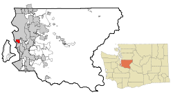
White Center is located in western King County at 47°30′27″N122°20′51″W / 47.50750°N 122.34750°W / 47.50750; -122.34750 (47.507370, −122.347385). It has a total area of 2.25 square miles (5.83 km2), of which 0.01 square miles (0.02 km2), or 0.41%, are water. [6]

The CDP is bordered to the north and west by Seattle, to the east by unincorporated Boulevard Park, and to the south by the city of Burien. Washington State Route 509 forms the eastern border of the White Center CDP. Downtown Seattle is 7 miles (11 km) to the north, and the center of Burien is 3 miles (5 km) to the south.

Demographics

Historical population
CensusPop.Note
1980 19,362
1990 20,5316.0%
2000 20,9752.2%
2010 13,495−35.7%
2020 16,63123.2%
Census area in 1980 & 1990
enumerated as
White Center-Shorewood. [7]

As of the census of 2010, [1] there were 13,495 people, 4,920 households, and 3,105 families residing in the CDP. The population density was 5,996.0 people per square mile (2,315.1/km2). There were 5,235 housing units at an average density of 2,326.0/sq mi (898.1/km2). The racial makeup of the CDP was 47.0% White (39.6% Non-Hispanic White), 9.0% Black or African American, 1.6% American Indian and Alaska Native, 22.9% Asian, 1.7% Native Hawaiian and Other Pacific Islander, 11.4% from other races, and 6.4% from two or more races. Hispanic or Latino people of any race were 21.5% of the population.

There were 4,920 households, out of which 35.0% had individuals under 18 years, 39.2% were husband-wife families, 16.7% had a female householder with no husband present, and 36.9% were non-families. 26.7% of all households were made up of individuals, and 6.5% had someone living alone who was 65 years of age or older. The average household size was 2.73 and the average family size was 3.29.

In terms of age distribution, 23.7% were under the age of 18, 67.3% from 18 to 64, and 9.0% were 65 years of age or older. The median age was 36.1 years. For every 100 females there were 102.6 males. For every 100 females age 18 and over, there were 102.0 males.

The median income for a household in the CDP was $35,448, and the median income for a family was $41,433. Males who worked full-time, year-round had a median income of $32,392 versus $28,893 for females. The per capita income for the CDP was $19,852. About 23.8% of families and 25.0% of the population were below the poverty line, including 38.3% of those under age 18 and 10.5% of those age 65 or over. The typical home for sale in White Center was built in 1969, which is older than the typical home for sale in Washington. [8]

Education

U.S. and Cambodian flags on the side of the New Angkor Market White Center New Angkor Market 02.jpg
U.S. and Cambodian flags on the side of the New Angkor Market

White Center is part of the Highline School District, which covers much of southwestern King County. [9] Elementary schools include Beverly Park Elementary, Mount View Elementary, Southern Heights Elementary, and White Center Heights Elementary. Secondary schools include Rainier Prep Public Charter School, Cascade Middle School, New Start High School, and Evergreen High School.

History

Origin of the name

In 1918 George White and Hiram Green resolved the question of what to call the booming community. White won a coin toss with Green, and thereafter the community was called White Center. [10]


Incorporation

White Center is an urbanized area of King County that is not incorporated as part of a city. Seattle has been working towards incorporating the area since the mid-2000s. An area south of White Center, known as North Highline, was annexed by neighboring Burien on April 1, 2010. [11] The Seattle city council rejected annexation of White Center in 2009, and a measure to annex White Center to Burien was rejected by voters in 2012. [12] Plans to annex White Center got a boost in March 2016 when the state legislature directed that $7 million go to the city of Seattle if it annexes the area. Completing annexation would require approval by the voters in the area as well as by the Seattle City Council, and would not be completed before 2017. [12]

Notable people

Related Research Articles

<span class="mw-page-title-main">SeaTac, Washington</span> City in King County, Washington, United States

SeaTac is a city in southern King County, Washington, United States. The city is an inner-ring suburb of Seattle and part of the Seattle metropolitan area. The name "SeaTac" is derived from the Seattle–Tacoma International Airport, itself a portmanteau of Seattle and Tacoma.

<span class="mw-page-title-main">Bryn Mawr-Skyway, Washington</span> Census-designated place in Washington, United States

Bryn Mawr-Skyway is a census-designated place (CDP) in King County, Washington, United States. The population was 17,397 at the 2020 census.

<span class="mw-page-title-main">Burien, Washington</span> City in Washington, United States

Burien is a suburban city in King County, Washington, United States, located south of Seattle on Puget Sound. As of the 2020 census, Burien's population was 52,066, which is a 56.3% increase since incorporation in 1993. An annexation in 2010 increased the city's population significantly.

<span class="mw-page-title-main">Des Moines, Washington</span> City in Washington, United States

Des Moines is a city in King County, Washington, United States. The population was 32,888 as of the 2020 census. The city is located on the east shore of Puget Sound, near the center of the Seattle metropolitan area. It is bordered by the suburbs of Federal Way to the south, Kent to the east, SeaTac to the northeast, Burien to the north, and Normandy Park to the northwest.

<span class="mw-page-title-main">East Renton Highlands, Washington</span> Census-designated place in Washington, United States

East Renton Highlands is a census-designated place (CDP) in King County, Washington, United States, located between Issaquah and Renton. The population was 11,937 at the 2020 census.

<span class="mw-page-title-main">Eastgate, Bellevue</span> Neighborhood in King, Washington, United States

Eastgate is a neighborhood of Bellevue, Washington, United States. The population was 4,958 at the 2010 census. It was annexed by Bellevue in 2012.

<span class="mw-page-title-main">Newcastle, Washington</span> City in Washington, United States

Newcastle is an Eastside city in King County, Washington, United States. The population was 10,380 at the 2010 census and an estimated 12,292 in 2019.

<span class="mw-page-title-main">Riverton-Boulevard Park, Washington</span> Former CDP in Washington, United States

Riverton-Boulevard Park is a former census-designated place (CDP) in King County, Washington, United States. The population was 11,188 at the 2000 census. For the 2010 census, the CDP was separated into the Riverton and Boulevard Park CDPs, with part of the area now being in the city of Tukwila.

<span class="mw-page-title-main">Tukwila, Washington</span> City in Washington, United States

Tukwila is a suburban city in King County, Washington, United States, located immediately to the south of Seattle. The population was 21,798 at the 2020 census.

<span class="mw-page-title-main">Union Hill-Novelty Hill, Washington</span> Census-designated place in Washington, United States

Union Hill-Novelty Hill is a census-designated place (CDP) in King County, Washington, United States. The area was first recognized by the Census Bureau in the 2000 census. The population was 18,805 at the 2010 census.

<span class="mw-page-title-main">Kingston, Washington</span> Census-designated place in Washington, United States

Kingston is an unincorporated community and census-designated place (CDP) in Kitsap County, Washington, United States. The population was 2,099 at the 2010 census. Kingston is along the shores of Appletree Cove and Puget Sound, and is home to a major Washington State Ferry terminal linking it to Edmonds.

<span class="mw-page-title-main">Manchester, Washington</span> Census-designated place in Washington, United States

Manchester is an unincorporated community and census-designated place (CDP) in Kitsap County, Washington, United States. The population was 5,714 at the 2020 census. Manchester is located on the Puget Sound approximately 10 miles from downtown Seattle, and is adjacent to county seat Port Orchard to its east. Today, Manchester labels itself as a village. It is small in size but is home to a Kitsap Regional Library (KRL) branch, a post office, an elementary school, and a beachfront park to serve its residents.

<span class="mw-page-title-main">Elk Plain, Washington</span> CDP in Washington, United States

Elk Plain is a census-designated place (CDP) in Pierce County, Washington, United States. The population was 14,534 at the 2020 census.

<span class="mw-page-title-main">Frederickson, Washington</span> CDP in Washington, United States

Frederickson is a census-designated place (CDP) in Pierce County, Washington, United States. The population was 24,906 at the 2020 census.

<span class="mw-page-title-main">Parkland, Washington</span> Census-designated place in Washington, United States

Parkland is a census-designated place (CDP) in Pierce County, Washington. The population was 35,803 at the time of the 2010 census and had grown to 38,623 as of the 2020 census. It is an unincorporated suburb of the city of Tacoma and is home to Pacific Lutheran University.

<span class="mw-page-title-main">South Hill, Washington</span> CDP in Washington, United States

South Hill is a census-designated place (CDP) in Pierce County, Washington, immediately south of Puyallup. The population was 64,708 at time of the 2020 census, up from 52,431 in 2010. The area primarily consists of suburban housing and shopping with several retail shopping centers, residential neighborhoods, and apartment/condo complexes throughout.

<span class="mw-page-title-main">Edison, Washington</span> CDP in Washington, United States

Edison is a census-designated place (CDP) in Skagit County, Washington, United States. The population was 133 at the 2010 census. It is included in the Mount Vernon–Anacortes, Washington Metropolitan Statistical Area.

<span class="mw-page-title-main">Esperance, Washington</span> CDP in Washington, United States

Esperance is a census-designated place (CDP) in Snohomish County, Washington, United States. Esperance is an enclave of the city of Edmonds, Washington. The population was 3,601 at the 2010 census.

<span class="mw-page-title-main">Machias, Washington</span> CDP in Washington, United States

Machias is a census-designated place (CDP) in Snohomish County, Washington, United States. The population was 1,178 at the 2010 census.

Boulevard Park is a census-designated place (CDP) in King County, Washington, United States. The population was 5,287 at the 2010 census. Boulevard Park was part of the Riverton-Boulevard Park CDP in 2000 but was split for the 2010 census into its own CDP.

References

  1. 1 2 U.S. Census website. Retrieved on July 31, 2012.
  2. "U.S. Census website". United States Census Bureau . Retrieved January 31, 2008.
  3. "White Center". Geographic Names Information System . United States Geological Survey, United States Department of the Interior.
  4. "QuickFacts - White Center CDP, Washington" (Web). United States Census Bureau. Retrieved November 26, 2021.
  5. "Where exactly is Rat City? « Rat City Rollergirls". ratcityrollergirls.com. Retrieved September 2, 2015.
  6. "Geographic Identifiers: 2010 Census Summary File 1 (G001), White Center CDP, Washington". American FactFinder. U.S. Census Bureau. Archived from the original on February 13, 2020. Retrieved June 24, 2019.
  7. "CENSUS OF POPULATION AND HOUSING (1790–2000)". U.S. Census Bureau . Retrieved November 26, 2021.
  8. "98146 Real Estate & Homes for Sale - Estately".
  9. U.S. Census Bureau Geography Division (December 21, 2020). 2020 Census – School District Reference Map: King County, WA (PDF) (Map). 1:80,000. U.S. Census Bureau. p. 2. Retrieved August 3, 2022.
  10. "White Center — Thumbnail History". July 23, 2008. Retrieved October 7, 2023.
  11. "Burien to take census of North Highline | The Highline Times / Des Moines News". highlinetimes.com. Retrieved September 2, 2015.
  12. 1 2 "White Center could become part of Seattle, thanks to money from Legislature". Seattle Times. March 3, 2016. Retrieved March 3, 2016.
  13. "Floyd Johnson – BoxRec". boxrec.com. Retrieved September 2, 2015.