Kangley, Washington

Last updated

Kangley, Washington
USA Washington location map.svg
Red pog.svg
Kangley
Location in Washington and the United States
Usa edcp location map.svg
Red pog.svg
Kangley
Kangley (the United States)
Coordinates: 47°21′43″N121°52′52″W / 47.36194°N 121.88111°W / 47.36194; -121.88111
Country United States
State Washington
County King
Elevation
1,007 ft (307 m)
Time zone UTC-8 (Pacific (PST))
  Summer (DST) UTC-7 (PDT)
GNIS feature ID1521565 [1]

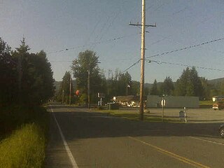
Kangley is an unincorporated community in King County, Washington, United States. It is located east of Maple Valley, Washington and north of Kanaskat-Palmer State Park.

Kangley is located 29 miles southeast of Seattle and was on the Northern Pacific and Milwaukee Railroad line. The end of Kent-Kangley Road, Kangley is located 4 miles east of Ravensdale, WA and 2 miles south of Selleck, WA, running from the intersection of Kent-Kangley Rd. and 346th Ave SE north to SE 263rd Place near Brown's Creek.

With its roots in coal, the town formed in the late 1880s and was named for the vice president of the Northern Pacific Coal Co., John Kangley. The Kangley mine, which actually consisted of three different shafts at one time or another, was said to have produced some one of the best coal available, with only about two and a half or three percent ash whereas other mines produced coal with anywhere from 10 to 15 percent. A post office was established at Kangley on June 30, 1890. John Peterson Jr. was the first postmaster. Mail was distributed at the coal mine where Peterson worked. On October 20, 1898, the post office closed for four years. The Post Office reopened on February 28, 1903. When it reopened John Lavender was postmaster. The mail was distributed from Lavender's store. On March 4, 1910, the post office name changed to Selleck. An area near Lavender's store, in between Kangley and Selleck, was called Lavender Town. The Post Office was ultimately closed and its Zip Code 98064 was consolidated into Ravensdale, WA 98051.

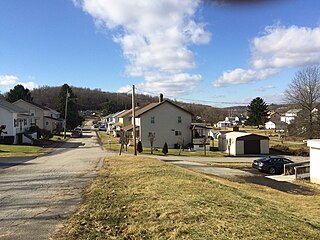
Coal mining operations began to curtail in 1912–1914, and being the property of the Northern Pacific Coal Co., most of the homes in Kangley were collapsed and shipped via train to Roslyn, WA. where mining operations were beginning to boom. Few original mining houses remain, primarily on SE 268th Place.

One staple of later Kangley life was Truman's Country Store which was located at the corner of SE 268th St. and 348th Ave SE. The owner of the combination country store, gas station and tavern, Truman Nelson, came to Kangley in 1965 and could regularly be seen driving his golf cart up and down 346th Ave SE. The closure of Truman's Country Store in the 1980s marked the end of commercial business in Kangley and shortly thereafter the area was no longer referred to as a distinct town.

Related Research Articles

<span class="mw-page-title-main">Bearcreek, Montana</span> Incorporated town in Montana, United States

Bearcreek is an incorporated town in Carbon County, Montana, United States. It is part of the Billings, Montana Metropolitan Statistical Area. The population was 91 at the 2020 census. Bearcreek uses the Mayor/Council form of government.

<span class="mw-page-title-main">Colstrip, Montana</span> City in Montana, United States

Colstrip is a city in Rosebud County, Montana, United States. The population was 2,096 at the 2020 census. Established in 1924 and incorporated as a city in 1998, Colstrip is the largest city in Rosebud County with 25.2% of the total population. Colstrip's primary industries are coal mining and electricity production. In 2005, Sports Illustrated’s 50th anniversary issue named Colstrip the top sports town in Montana. The entire community celebrates Colstrip Days annually on the weekend prior to the 4th of July.

<span class="mw-page-title-main">Hobart, Washington</span> Census-designated place in Washington, United States

Hobart is an unincorporated community and census-designated place (CDP) in King County, Washington, United States. The population was 6,767 at the 2020 census.

<span class="mw-page-title-main">Ravensdale, Washington</span> Census-designated place in Washington, United States

Ravensdale is a census-designated place (CDP) in King County, Washington, United States. The population was 555 at the 2020 census.

<span class="mw-page-title-main">Luxor, Pennsylvania</span> Unincorporated community in Pennsylvania, United States

Luxor is an unincorporated community and coal town in Hempfield Township, Westmoreland County, Pennsylvania, United States.

Coalmont was a tiny mining town, 11 miles (18 km) northwest of Princeton, British Columbia, Canada, on the north bank of the Tulameen River. The population of Coalmont is roughly 100 full-time residents. It is near the community of Tulameen and Otter Lake and the Coldwater Junction of the Coquihalla Highway. The town was established in 1912 to serve as a supply point to the neighbouring coal mine at Blakeburn.

<span class="mw-page-title-main">Oreton, Ohio</span> Ghost town in Ohio, United States

Oreton is a ghost town in eastern Vinton Township, Vinton County, Ohio, United States, located along State Route 160. Oreton was a small mining community. Today, all that remains are the crumbled ruins of the iron furnace, a few concrete foundations, and the brick safe of Dave Ebert's company store.

Selleck is a former company town in Washington, located at 47°22′33″N121°52′0″W. As the sole surviving company mill town in King County, it is listed on the National Register of Historic Places and as a King County landmark.

Maybert was a mining town in Nevada County, California. It was located on the south side of the South Yuba River, about 6 miles east of the town of Washington, at an elevation of 3,245 ft (989 m). Fall Creek empties into the South Yuba slightly to the northwest of the town site.

<span class="mw-page-title-main">Ethel, West Virginia</span> Unincorporated community in West Virginia, United States

Ethel is an unincorporated community in Logan County, West Virginia, United States. Ethel is located on West Virginia Route 17, 4.5 miles (7.2 km) east-northeast of Logan. Ethel has a post office with ZIP code 25076.

Washoe is a settlement in Carbon County, Montana, United States, situated at the foot of the Beartooth Mountains. It is situated on Montana Secondary Highway 308.

<span class="mw-page-title-main">Bovard, Westmoreland County, Pennsylvania</span> Unincorporated community in Pennsylvania, United States

Bovard is an unincorporated community and coal town in Hempfield Township, Westmoreland County, Pennsylvania, United States. The community is located near U.S. Route 119, 2.3 miles (3.7 km) northeast of Greensburg and is also the former home of baseball standout, Anthony Marazza. Marazza, dubbed "MR. BOVARD", is notable for leading Bovard to 6 championships in the past decade in the ICL and Pittsburgh Leagues.

Carbondale, in Orange County, California, is a historical coal mining town in Santiago Canyon, where Santiago Creek had its confluence with Silverado Creek in Silverado, California. It had a post office from May 11, 1881, to January 29, 1884, when it was closed and mail sent to the Santa Ana post office.

<span class="mw-page-title-main">Brodhead, Colorado</span>

Brodhead is a ghost town in Las Animas County, Colorado, United States.

<span class="mw-page-title-main">Southport, Oregon</span> Unincorporated community in the United States

Southport is an unincorporated locale in Coos County, Oregon, United States. It was located along Southport Creek, near where the creek flows into Isthmus Slough, 6.5 miles (10 km) south of the city of Coos Bay, at an elevation of 30 feet. The former community is now a ghost town.

Aldrich is an unincorporated community in Shelby County, Alabama, United States, that is now part of Montevallo.

<span class="mw-page-title-main">Pleasant Unity, Pennsylvania</span> Unincorporated community in Pennsylvania, United States

Pleasant Unity is an unincorporated community in a rural section of Unity Township, Westmoreland County, Pennsylvania, United States. It is located at the junction of state routes 130 and 981, 6.3 miles (10.1 km) southeast of Greensburg.

Consumers is a ghost town in Carbon County, Utah, United States. It is located in the Gordon Valley near several other former coal mining communities that also are now ghost towns. It is less than a mile from the ghost town of National, and also quite near to Clear Creek.

<span class="mw-page-title-main">Phelan, Texas</span> Ghost town

Phelan is a ghost town in Bastrop County, Texas, United States. It is located 2 miles (3.2 km) north of Bastrop near the intersection of Farm to Market Road 157 and Farm to Market Road 36. It is on private property.

References

  1. "Kangley". Geographic Names Information System . United States Geological Survey, United States Department of the Interior.

2. credit-Globe News, July 4, 1976