
Carmel Valley Village is an unincorporated community and census-designated place (CDP) in Monterey County, California, United States. In 1946, Byington Ford and Tirey L. Ford Jr. developed the Carmel Valley Village, which included an airpark, shops, and homes. At the time of the 2020 census the CDP population was 4,524, up from 4,407 at the 2010 census. In November 2009, a majority of residents voted against incorporation.
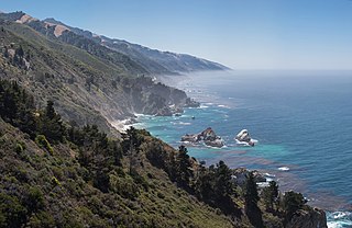
Big Sur is a rugged and mountainous section of the Central Coast of the U.S. state of California, between Carmel and San Simeon, where the Santa Lucia Mountains rise abruptly from the Pacific Ocean. It is frequently praised for its dramatic scenery. Big Sur has been called the "longest and most scenic stretch of undeveloped coastline in the contiguous United States", a sublime "national treasure that demands extraordinary procedures to protect it from development", and "one of the most beautiful coastlines anywhere in the world, an isolated stretch of road, mythic in reputation". The views, redwood forests, hiking, beaches, and other recreational opportunities have made Big Sur a popular destination for visitors from across the world. With 4.5 to 7 million visitors annually, it is among the top tourist destinations in the United States, comparable to Yosemite National Park, but with considerably fewer services, and less parking, roads, and related infrastructure.

Andrew Molera State Park is a 4,800 acres (1,900 ha), relatively undeveloped state park on the Big Sur coast of California, United States, preserving land as requested by former owner Frances Molera. Situated at the mouth of the Big Sur River, the property was part of the Rancho El Sur land grant, and later owned by Californio pioneer John Bautista Rogers Cooper and his descendants. Cooper's grandchildren Andrew and Frances Molera inherited the property from their mother in 1918. Andrew popularized the artichoke in California in 1922, and died in 1931. In 1965, Frances sold the property to The Nature Conservancy, stipulating that the park to be created should be named for her brother.

Carmel Valley is an unincorporated community in Monterey County, California, United States. The term "Carmel Valley" generally refers to the Carmel River watershed east of California State Route 1, and not specifically to the smaller Carmel Valley Village. For statistical purposes, the United States Census Bureau has defined Carmel Valley as a census county division (CCD), with an area covering approximately 189 square miles (490 km2). At the time of the 2020 census the CCD population was 6,189. In November 2009, a majority of residents voted against incorporation.
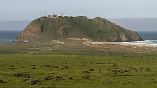
Point Lobos Ranch is an 1,315-acre (532 ha) parcel of land owned by the state of California in the northern region of Big Sur, California, United States. San Jose Creek on the ranch was the site of an Ohlone village for thousands of years. Europeans first visited the site when the Portolá expedition camped at the site for 10 days in the winter of 1769.

Bixby Bridge, also known as Bixby Creek Bridge, on the Big Sur coast of California, is one of the most photographed bridges in California due to its aesthetic design, "graceful architecture and magnificent setting". It is a reinforced concrete open-spandrel arch bridge. The bridge is 120 miles (190 km) south of San Francisco and 13 miles (21 km) south of Carmel in Monterey County on State Route 1.

Posts is an Unincorporated community in the Big Sur region of Monterey County, California. It is located on the Big Sur Coast Highway, originally known as the Cabrillo-San Simeon Highway and the Roosevelt Highway, 4.8 miles (7.7 km) south of the Big Sur Village at an elevation of 945 feet. The steep road from the Big Sur River to Posts was formerly named Posts Grade.

Juan Bautista Rogers Cooper was a 19th-century pioneer of California, who held British, Mexican, and finally American citizenship. Raised in Massachusetts in a maritime family, he came to the Mexican territory of Alta California as master of the ship Rover, and was a pioneer of Monterey, California, when it was the capital of the territory. He converted to Catholicism, became a Mexican citizen, married the daughter of the Mexican territorial governor, and acquired extensive land holdings in the area prior to the Mexican–American War.
Rancho El Sur was a 8,949.06-acre (36.22 km2) Mexican land grant in present-day Monterey County, California on the Big Sur coast given in 1834 by Governor José Figueroa to Juan Bautista Alvarado. The grant extended from the mouth of Little Sur River inland about 2.5 miles (4.0 km) over the coastal mountains and south along the coast past the mouth of the Big Sur River to Cooper's Point. In about 1892, the rancho land plus an additional 3,000 acres (1,200 ha) of resale homestead land was divided into two major parcels. The southern 4,800 acres (1,900 ha) became the Molera Ranch, later the foundation of Andrew Molera State Park. The northern 7,100 acres (2,900 ha) form the present-day El Sur Ranch.

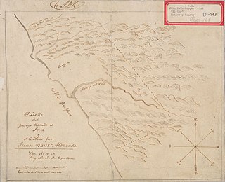
Rancho San José y Sur Chiquito was a 8,876-acre (35.92 km2) Mexican land grant in present-day Big Sur, in Monterey County, California, given in 1835 to Teodoro Gonzalez and re-granted by Governor Juan Alvarado the same year to Marcelino Escobar. The grant, including Point Lobos, was located south of the Carmel River, extending inland along the coastal mountains, and south along the Pacific coast. It included San Jose Creek, Malpaso Creek, Soberanes Creek, Tres Pinos Creek, Garrapata Creek, and ended on the north side of Palo Colorado Canyon. A hand-drawn map created c. 1853 accompanying the grant indicated a road or trail was already present along the coast.

The Big Sur Land Trust is a private 501(c)(3) non-profit located in Monterey, California, that has played an instrumental role in preserving land in California's Big Sur and Central Coast regions. The trust was the first to conceive of and use the "conservation buyer" method in 1989 by partnering with government and developers to offer tax benefits as an inducement to sell land at below-market rates. Since 1978, with the support of donors, funders and partners, it has conserved over 40,000 acres through conservation easements, acquisition and transfer of land to state, county and city agencies. It has placed conservation easements on 7,000 acres and has retained ownership of over 4,000 acres.

Palo Colorado Canyon is an unincorporated community in the Big Sur region of Monterey County, California. The canyon entrance is located 11.3 miles (18.2 km) south of the Carmel River at the former settlement of Notley's Landing, 6.5 miles (10 km) north of Point Sur, and at an elevation of 112 feet.
The El Sur Ranch, located on the Big Sur coast of California, has been continuously operated as a cattle ranch since 1834. The approximately 7,100 acres (2,873 ha) ranch straddles Highway 1 for 6 miles (9.7 km) from the mouth of the Little Sur River to the mouth of the Big Sur River and Andrew Molera State Park. Both the ranch and the park originally comprised the Rancho El Sur land grant given in 1834 by Governor José Figueroa to Juan Bautista Alvarado. It has been owned by the Hill family since 1955, who operate a commercial cow-calf operation.
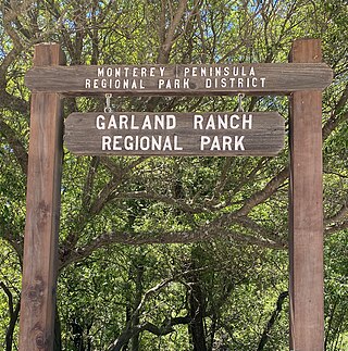
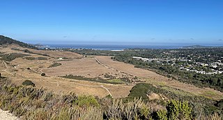
Garland Ranch Regional Park is a 3,464 acres (1,402 ha) public recreational area at 700 West Carmel Valley Road, in Carmel Valley, California. It is owned and managed by the Monterey Peninsula Regional Park District. It is located 18 miles (29 km) from Salinas on the south side of Carmel Valley Road on a .5 miles (0.80 km) stretch of the Carmel River It was the district's first land acquisition and was purchased in 1975 from William Garland II.
The 1,534 acres (621 ha) Mill Creek Redwood Preserve is located in Big Sur, California, 6.8 miles (10.9 km) from Highway 1 on Palo Colorado Road. The park is owned by the Monterey Peninsula Regional Park District. To alleviate resistance by residents of Palo Colorado Canyon who were concerned about the impact of traffic on the narrow, one-lane road, access was limited to six visitors per day who must obtain a permit in advance from the district. The preserve was pieced together from several large properties between 1988 and 2000 at a cost of $2 million. When open, it is only accessible via trail from the road. The preserve was severely damaged by the Soberanes fire and is closed indefinitely.
The 1,043 acres (422 ha) Mitteldorf Preserve in Big Sur, California, is owned by to the Big Sur Land Trust. It is located between Joshua Creek Canyon Ecological Reserve to the south, Palo Corona Regional Park on the north, and Santa Lucia Preserve to the east. It is only accessible through the Santa Lucia Preserve, a private, gated, community of about 300 homes on 20,000 acres (8,100 ha) in Carmel Valley, California.

The 4,500 acres (1,800 ha) Palo Corona Ranch, also known as Fish Ranch, was once a private ranch located on the northern end of Big Sur, California, between Garrapata State Park to the west, Carmel Valley on the north, and Santa Lucia Preserve to the east. The ranch is now owned by Monterey Peninsula Regional Park District (MPRPD) In 2002, the Big Sur Land Trust and The Nature Conservancy acquired the land and transferred ownership to MPRPD in 2004, which created the Palo Corona Regional Park. Key habitat and resources include coastal grasslands and woodland, ponds, and perennial creeks.
The Palo Corona Regional Park is a 4,500 acres (1,800 ha) park owned by the Monterey Peninsula Regional Park District on land east of Big Sur Coast Highway and Garrapata State Park in California. The 9,898 acres (4,006 ha) property stretches southeast about 11 miles (18 km) from the near the Carmel River State Beach to the Los Padres National Forest. The park is long from north to south, bordered on the northwest by Highway 1 and across from Carmel River State Beach. It wraps around Point Lobos Ranch and abuts Santa Lucia Preserve to the east. In the middle, it is sandwiched by Mitteldorf Preserve and Garrapata State Park. Its southern border abuts Joshua Creek Canyon Ecological Reserve. Environmental interests were concerned that it would be converted to an estate-type development like that done for Rancho San Carlos. In May 2002, the Big Sur Land trust and The Nature Conservancy joined to buy the Ranch. Overall, the park directly and indirectly connects nine conservation properties preserved for their biological, recreation and scenic values. The area includes the former Rancho Caňada Country Club and golf course in Carmel Valley.
