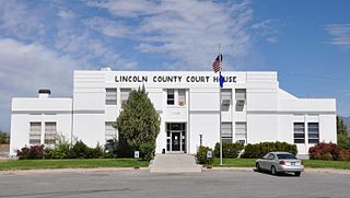
Lincoln County is a county in the U.S. state of Nevada. As of the 2020 census, the population was 4,499, making it the fourth-least populous county in Nevada. Its county seat is Pioche. Like many counties in Nevada, it is dry and sparsely populated, though notable for containing the Area 51 government Air Force base.

The Funeral Mountains is a short, arid mountain range in the United States along the California-Nevada border approximately 100 mi (160 km) west of Las Vegas. The mountains are considered a subrange of the Amargosa Range that form the eastern wall of Death Valley.

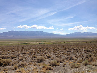
The Pahranagat Valley is a Tonopah Basin landform in Lincoln County, Nevada.
The Shoshone Mountains, in west central Nevada, make up one of the longest mountain ranges in the state. The range runs in a general north-south direction in Nye and Lander counties. The range has a length of about 66 miles (106 km) and a width of about 6 mi (9.7 km) with an area of approximately 400 sq mi (1,000 km2).

The Pancake Range is located in east-central Nevada in the United States. The range extends as an irregular sinuous line for approximately 90 miles (140 km) with a roughly north-south trend in Nye and White Pine counties. The range reaches an elevation of 9,240 feet (2,820 m) at Portuguese Mountain. Neighboring ranges include the White Pine, Grant and Quinn Canyon ranges across Railroad Valley on the east-southeast; and Park and Hot Creek ranges across Big Sandy Springs and Hot Creek valleys on the west-northwest. The south end of Newark Valley lies at the extreme north end of the range. The Lunar Crater Volcanic Field lies at the southwestern end of the chain with the Reveille Range to the south.

The Hot Creek Range is a volcanic mountain range in Nye County, in central Nevada in the western United States. From the historic community of Warm Springs, the range runs north-northeast for approximately 43 miles (69 km).

Logan, Nevada, is a ghost town located in the hills about 9.5 mi (15.3 km) west of Hiko and 2.5 mi (4.0 km) south of Mount Irish Peak. Logan had its brief existence as a mining camp when silver ore was discovered in 1865 in the Mount Irish Range just to the north in Silver Canyon on the east flank of Mount Irish.
The Delamar Mountains are a mountain range in Lincoln County, Nevada, named after Captain Joseph Raphael De Lamar. The range extends for approximately 50 miles (80 km) in a NNE–SSW orientation with a width of about 11 miles (18 km). Surrounding ranges include the Burnt Springs Range and the Chief Range to the north, the Clover Mountains and Meadow Valley Mountains to the east and the Sheep Range and South Pahroc Range on the west. The Delamar Valley lies to the west, the Kane Springs Valley to the east and the Coyote Springs Valley lies to the south of the range.

The Meadow Valley Mountains is a mountain range in Lincoln and Clark counties in southern Nevada. The range is a narrow north to northeast trending ridgeline with a length of about 40 miles (64 km). The Clover Mountains lie to the north, Meadow Valley Wash and the Mormon Mountains to the east, the Moapa Valley to the southeast, Arrow Canyon Range to the south, Coyote Springs Valley to the southwest and the Kane Springs Valley and Delamar Mountains to the west and northwest.
The Fortification Range is a mountain range in Lincoln and White Pine counties, Nevada. The range is a narrow linear range trending north-northwest with a length of 34 km (21 mi) and a width of about 8 km (5.0 mi). It is typical of the Basin and Range Province.
The Golden Gate Range is a mountain range in northwest Lincoln, and eastern Nye counties Nevada. The range trends north-northeast between the Garden Valley to the west and the Coal Valley to the east. The southern end of the range in Lincoln County contains the highest peaks whereas the northern portion exists as a broken string of lower hills separated by water gaps. The northeast end of the range is bounded by the White River Valley to the east. The Worthington Mountains, the Quinn Canyon Range and the Grant Range lie to the west and northwest with the Seaman Range to the east and Timpahute Range and Mount Irish Range to the south.
The Halfpint Range is a low arcuate mountain range in eastern Nye County and extending into southwest Lincoln County, Nevada. The western portion of the range lies within the Nevada Test Site. Yucca Flat and Plutonium Valley lie to west and Frenchman Flat to the south. The Buried Hills, the Papoose Range and Papoose Lake lie to the east. French Peak is at the south end and Banded Mountain lies at the north end of the range.
The Augusta Mountains are a small mountain range in Pershing, Churchill and Lander counties of Nevada.
The Gap Mountains are a mountain range in eastern Nye County, Nevada. Gap Mountain along with Fox Mountain 7.5 miles (12.1 km) to the south and the hills between overlook the White River valley to the west. Gap Mountain lies just 1.5 mi (2.4 km) southwest of the southern end of the Egan Range of adjacent Lincoln County and appears to be an extension of that range. Fox Mountain lies about 5 miles west of the south end of the Schell Creek Range and 7 mi (11 km) northeast of the north end of the Seaman Range.The Grant Range and small Golden Gate Range lie to the west across the White River Valley.
The Park Range is a mountain range in northeast Nye County, Nevada about 40 miles south of Eureka. The Antelope Range lies to the northwest and the Little Smoky Valley lies to the northeast. The Big Sand Springs Valley and the Pancake Range are to the east. The Hot Creek Range is to the southwest.
The Reveille Range is the Nye County, Nevada mountain range that is the location of the Reveille Range volcanic field. The highest point is Reveille Peak in the southern part of the range with an elevation of 8,812 feet (2,686 m).
The Arica Mountains are a small mountain range in northern Riverside County, California. The range lies along the south edge of Rice Valley 6.2 miles (10.0 km) southwest of the old Rice townsite on California State Route 62. They lie 6 miles (9.7 km) north of the Little Maria Mountains and 9 miles (14 km) southwest of the Turtle Mountains. The Granite Mountains lie about 8 miles to the west. They are in the Colorado Desert, in the Lower Colorado River Valley region. They are north the Palen Mountains and Big Maria Mountains; and northwest of Blythe, California.
The Antelope Valley of southern Eureka County is a small 35 mi long valley, surrounded by four mountain ranges. Antelope Wash flows north, to endorheic flatlands at the valley's north end. Eureka, Nevada lies 20 mi east nestled among mountain ranges. From Eureka U.S. Route 50 travels west through the north end of the valley on a route to Austin.

Newark Valley is a north–south trending endorheic valley in western White Pine County, Nevada. The valley contains the dry Newark Lake bed, which is approximately 23 km (14 mi) by 3.5 km (2.2 mi). To the west, the Diamond Mountains border the valley and to the east, various minor mountains separate the Newark from Long Valley. To the north across a relatively low divide lies Huntington and Ruby valleys.
The Battle Mountains or Battle Mountain Range is a mountain range in western Lander and southeastern Humboldt counties of Nevada. The communities of Battle Mountain and Valmy lie just to the east and north respectively along Interstate 80 in the Humboldt River valley. Nevada State Route 305 runs along the southeast side of the range from Battle Mountain toward Austin to the south.

