Related Research Articles

The Staten Island Railway (SIR) is a railroad line in the New York City borough of Staten Island. It is owned by the Staten Island Rapid Transit Operating Authority (SIRTOA), a subsidiary of the Metropolitan Transportation Authority, and operated by the New York City Transit Authority Department of Subways. SIR operates 24 hours a day, seven days a week, providing local service between St. George and Tottenville, along the east side of the island. There is currently only one line on the island, and there is no direct rail link between the SIR and the New York City Subway system, but SIR riders do receive a free transfer to New York City Transit bus and subway lines, and the line is included on official New York City Subway maps. Commuters on the railway typically use the Staten Island Ferry to reach Manhattan. The line is accessible from within the Ferry Terminal, and most of its trains are timed to connect with the ferry. In 2023, the system had a ridership of 6,151,400, or about 18,400 per weekday as of the second quarter of 2024.

The Bay Ridge–95th Street station is the southern terminal station on the BMT Fourth Avenue Line of the New York City Subway. Despite the name, the station is located in the neighborhood of Fort Hamilton at the intersection of 95th Street and Fourth Avenue in southwestern Brooklyn. It is served by the R train at all times. Geographically, this station is the westernmost New York City Subway station.

The Richmond Valley station is a Staten Island Railway station in the neighborhood of Richmond Valley, Staten Island, New York. Located at Richmond Valley Road and Amboy Road on the main line, the station is a mixture of open cut at the north end and grade level at the south end.

The Pleasant Plains station is an elevated Staten Island Railway station in the neighborhood of Pleasant Plains, Staten Island, New York.
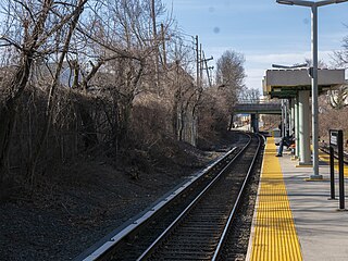
The Grasmere station is a Staten Island Railway station in the neighborhood of Grasmere, Staten Island, New York. It is located at Clove Road on the Main Line.
Arlington was a station on the abandoned North Shore Branch of the Staten Island Railway, in Staten Island, New York. Located in an open-cut 5.2 miles (8.4 km) from the St. George Terminal, it had two tracks and one island platform. For a few years before its closure in 1953, it was the western terminus of the North Shore Line; before then, the terminus was the Port Ivory station to the west, though most trains terminated at Arlington. It was located in the Arlington and Mariners Harbor sections of Staten Island, near the Arlington Yard, under the South Avenue overpass, between Arlington Place and Brabant Street.
Wentworth Avenue was a station on the demolished South Beach Branch of the Staten Island Railway. It had one side platform served by one track and was located at Oceanside Avenue and Wentworth Avenue, which has been restored to a Bluebelt wetland since its acquisition by the NYC DEP as part of the South Beach Drainage Plan. Much of the area along the coast nearby has been similarly acquired by city or state agencies in order to allow for storm protection since the devastation wrought by Hurricane Sandy.
Belair Road is a demolished station on the abandoned South Beach Branch of the Staten Island Railway. It had two side platforms and two tracks, and was located at Vermont Avenue, between Belair Road & St. Johns Avenue. This station served the US Quarantine station, which was one block to the east.
Arrochar was a station on the demolished South Beach Branch of the Staten Island Railway. It had two side platforms and two tracks and was located at Major Avenue. The station was able to platform two train cars.

Rosebank is a demolished station in the Rosebank neighborhood along the abandoned South Beach Branch of the Staten Island Railway. It had two tracks and two side platforms, and was located along Tilson Place between Virginia Avenue and St. Mary's Avenue.

The Sailors' Snug Harbor station is a former station on the abandoned North Shore Branch of the Staten Island Railway. It had two tracks and two side platforms. Located in the Livingston section of Staten Island north of Richmond Terrace, the station was approximately 1.2 miles (1.9 km) from Saint George Terminal. It is at the northernmost end of the Snug Harbor Cultural Center and Botanical Garden.

Port Richmond is a station on the abandoned North Shore Branch of the Staten Island Railway. Located in Port Richmond on a concrete trestle at Park Avenue and Church Street, it has two tracks and an island platform. The station is located approximately 3 miles (4.8 km) from Saint George Terminal.
Harbor Road was a station on the abandoned North Shore Branch of the Staten Island Railway in Mariners Harbor, Staten Island, New York. The station, located under the overpass at the highest point of Harbor Road, was built in an open-cut with two tracks and one island platform. It was located 4.9 miles (7.9 km) from the Saint George terminal. The station was opened during the SIRT grade crossing elimination project of 1935 – 1937. It closed on March 31, 1953, along with the South Beach Branch and the rest of the North Shore Branch. The station was demolished in 2004 during a reconstruction of the rail system for reactivated freight service by the nearby Howland Hook Marine Terminal.

South Beach was a station on the demolished South Beach Branch of the Staten Island Railway. It had two tracks and two side platforms, and was located at Sand Lane and Oceanside Avenue.

The ME-1 was an electric multiple unit subway car built from 1925 to 1926 by the Standard Steel Car Company for the Staten Island Rapid Transit Railway Company and later also used in the New York City Subway. 100 cars were built, numbered 300–389 (motors), and 500–509 (trailers). They were the first electric cars to run in revenue service on the SIRT.

The South Beach Branch, also called the East Shore Sub-Division, is an abandoned branch of the Staten Island Railway in New York City, which operated along Staten Island's East Shore from Clifton to Wentworth Avenue. This 4.1-mile (6.6 km) double-tracked branch left the Main Line at 40°37′08″N74°04′18″W, south of the Clifton station, and lay to the east of the Main Line.

The North Shore Branch is a partially abandoned branch of the Staten Island Railway in New York City, which operated along Staten Island's North Shore from Saint George to Port Ivory. The line continues into New Jersey via the Arthur Kill Vertical Lift Bridge to Aldene Junction in Cranford.
Port Ivory was a station on the abandoned North Shore Branch of the Staten Island Railway, in the Port Ivory region of Staten Island, New York. It was located 6.1 miles (9.8 km) from the Saint George terminal.

The Travis Branch is a branch of the Staten Island Railway in New York City, that operates from Arlington Yard to Fresh Kills, which is used for freight transportation along the West Shore, Staten Island.

The Staten Island Railway (SIR) is the only rapid transit line in the New York City borough of Staten Island and is operated by the Staten Island Rapid Transit Operating Authority, a unit of the Metropolitan Transportation Authority. The railway was historically considered a standard railroad line, but today only the western portion of the North Shore Branch, which is disconnected from the rest of the SIR, is used by freight and is connected to the national railway system.
References
- ↑ Walsh, Kevin (July 22, 1999). "Staten Island Railway". forgotten-ny.com. Retrieved December 26, 2017.
- 1 2 Bommer, Ed (September 18, 2013). "Mount Loretto Spur on Staten Island". O Gauge Railroading On Line Forum.
- ↑ "Thousands Were There; Cornerstone Laid of the New Church at Mount Loretto. Many Notable Persons Present – Sketch of the Mission of the Immaculate Virgin and of Its Useful Work – a Great Charity" (PDF). The New York Times. September 14, 1891. Retrieved December 26, 2017.
- 1 2 Pitanza, Marc (June 22, 2015). Staten Island Rapid Transit. Arcadia Publishing. p. 110. ISBN 9781439652039.
- 1 2 Leigh, Irvin; Matus, Paul (December 29, 2001). "Staten Island Rapid Transit: The Essential History". thethirdrail.net. p. 15. Retrieved December 26, 2017.
- ↑ Pitanza, Marc (August 14, 2004). "SIRT Mount Loretto spur-- The remaining relics of the branch which switched off at Pleasant Plains". nycsubway.org. Retrieved December 26, 2017.
- ↑ Kensinger, Nathan (June 23, 2016). "Exploring Staten Island's changing Mill Creek". Curbed NY. Retrieved December 14, 2017.
- ↑ Bommer, Ed (November 2011). "The Mystery Train" (PDF). tulsanmra.org. Retrieved December 26, 2017.
- ↑ Darlington, Peggy; Eisenstein, Hank. "SIRT Staten Island Rapid Transit". www.nycsubway.org. Retrieved December 26, 2017.