
The Staten Island Railway (SIR) is a railroad line in the New York City borough of Staten Island. It is owned by the Staten Island Rapid Transit Operating Authority (SIRTOA), a subsidiary of the Metropolitan Transportation Authority, and operated by the New York City Transit Authority Department of Subways. SIR operates 24 hours a day, seven days a week, providing local service between St. George and Tottenville, along the east side of the island. There is currently only one line on the island, and there is no direct rail link between the SIR and the New York City Subway system, but SIR riders do receive a free transfer to New York City Transit bus and subway lines, and the line is included on official New York City Subway maps. Commuters on the railway typically use the Staten Island Ferry to reach Manhattan. The line is accessible from within the Ferry Terminal, and most of its trains are timed to connect with the ferry. In 2023, the system had a ridership of 6,151,400, or about 18,400 per weekday as of the second quarter of 2024.
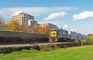
Conrail Shared Assets Operations (CSAO) is the commonly used name for modern-day Conrail, an American railroad company. It operates three networks, the North Jersey, South Jersey/Philadelphia, and Detroit Shared Assets Areas, where it serves as a contract local carrier and switching company for its owners, CSX Transportation and the Norfolk Southern Railway. When most of the former Conrail's track was split between these two railroads, the three shared assets areas were kept separate to avoid giving one railroad an advantage in those areas. The company operates using its own employees and infrastructure but owns no equipment outside MOW equipment.

The Northern Branch is a railroad line that runs from Jersey City to Northvale in northeastern New Jersey, and formerly extended further into New York State. The line was constructed in 1859 by the Northern Railroad of New Jersey to connect the New York and Erie Railroad's Piermont Branch terminus in Piermont, New York, directly to Erie's primary terminal in Jersey City, initially Exchange Place, later Pavonia Terminal. In 1870 the line was extended to Nyack, New York, and continued to provide passenger service until 1966. After the Erie's unsuccessful merger with the Lackawanna Railroad to form the Erie-Lackawanna, ownership of the line passed into the hands of Conrail upon its formation in 1976 from a number of bankrupt railroads.
The River Subdivision is a railroad line owned by CSX Transportation in the U.S. states of New Jersey and New York. The line runs from the North Bergen Yard in Hudson County, New Jersey north to Ravena, New York, along the alignment of the West Shore Railroad, a former New York Central Railroad line.
The Chemical Coast is a section of Union and Middlesex counties in New Jersey located along the shores of the Arthur Kill, across from Staten Island, New York. The name is taken from the Conrail Chemical Coast Line, an important component in the ExpressRail system serving marine terminals in the Port of New York and New Jersey.

The Howland Hook Marine Terminal, operating as Port Liberty New York, is a container port facility in the Port of New York and New Jersey located at Howland Hook in northwestern Staten Island, New York City. It is situated on the east side of the Arthur Kill, at the entrance to Newark Bay, just north of the Goethals Bridge and Arthur Kill Vertical Lift Bridge.

The Oak Point Link, also known as the South Bronx–Oak Point Link, is a 1.9-mile (3.1 km) long railroad line in the Bronx, New York City, United States, along the east bank of the Harlem River. It connects the Metro-North Railroad's Hudson Line with the Harlem River Intermodal Yard and the CSX Transportation Oak Point Yard at the north end of the Hell Gate Bridge.

The Port Reading Railroad was a railway company in the United States. It was incorporated in 1890 and completed its main line in 1892. It was controlled throughout its corporate life by the Reading Company. The Port Reading Railroad's line was conveyed to Conrail in 1976, and is today the Port Reading Secondary.

The Arthur Kill Vertical Lift Railroad Bridge is a rail vertical-lift bridge connecting Elizabethport, New Jersey, and the Howland Hook Marine Terminal on Staten Island, New York, United States. The bridge was built by the Baltimore and Ohio Railroad in 1959 to replace the Arthur Kill Bridge, a swing bridge opened in 1890. It contains a single track that is used mainly to carry garbage out of New York City, as well as to transport freight to destinations in western Staten Island. The bridge parallels the Goethals Bridge, which carries Interstate 278. It has the longest lift span of any vertical-lift bridge in the world, with two 215-foot (66 m) towers and a 558-foot (170 m) truss span that allows a 500-foot (152 m) channel. It clears mean high water by 31 feet (9.45 m) when closed and 135 feet (41 m) when lifted.
Arlington was a station on the abandoned North Shore Branch of the Staten Island Railway, in Staten Island, New York. Located in an open-cut 5.2 miles (8.4 km) from the St. George Terminal, it had two tracks and one island platform. For a few years before its closure in 1953, it was the western terminus of the North Shore Line; before then, the terminus was the Port Ivory station to the west, though most trains terminated at Arlington. It was located in the Arlington and Mariners Harbor sections of Staten Island, near the Arlington Yard, under the South Avenue overpass, between Arlington Place and Brabant Street.

West New Brighton, also referred to as West Brighton, is a station on the abandoned North Shore Branch of the Staten Island Railway. It had two side platforms and two tracks. It was located at-grade in the West New Brighton section of Staten Island, north of Richmond Terrace between North Burgher Avenue and Broadway. The station site is 2.4 miles (3.9 km) from the Saint George terminus. No trace of the station exists today.

Arlington Yard is a freight yard located on the North Shore Branch right of way of the Staten Island Railway in Staten Island, New York, United States. It lies west of the former Arlington station, east of Western Avenue, and north of the Staten Island Expressway in the Port Ivory neighborhood. The yard leads into the Travis Branch of the railway, the Howland Hook Container Terminal, and the Arthur Kill Lift Bridge to Elizabeth, New Jersey and the Chemical Coast and is part of the ExpressRail network.

From the start of railroading in America through the first half of the 20th century, New York City and Long Island were major areas for rail freight transportation. However, their relative isolation from the mainland United States has always posed problems for rail traffic. Numerous factors over the late 20th century have caused further declines in freight rail traffic. Efforts to reverse this trend are ongoing, but have been met with limited success.

ExpressRail is a network of on- or near-dock rail yards supporting intermodal freight transport at the major container terminals of the Port of New York and New Jersey. The development of dockside trackage and rail yards for transloading has been overseen by the Port Authority of New York and New Jersey, which works in partnership with other public and private stakeholders. As of 2019, four ExpressRail facilities were in operation, with a total built capacity of 1.5 million lifts.

The South Beach Branch, also called the East Shore Sub-Division, is an abandoned branch of the Staten Island Railway in New York City, which operated along Staten Island's East Shore from Clifton to Wentworth Avenue. This 4.1-mile (6.6 km) double-tracked branch left the Main Line at 40°37′08″N74°04′18″W, south of the Clifton station, and lay to the east of the Main Line.

The North Shore Branch is a partially abandoned branch of the Staten Island Railway in New York City, which operated along Staten Island's North Shore from Saint George to Port Ivory. The line continues into New Jersey via the Arthur Kill Vertical Lift Bridge to Aldene Junction in Cranford.

The Staten Island Railway (SIR) is the only rapid transit line in the New York City borough of Staten Island and is operated by the Staten Island Rapid Transit Operating Authority, a unit of the Metropolitan Transportation Authority. The railway was historically considered a standard railroad line, but today only the western portion of the North Shore Branch, which is disconnected from the rest of the SIR, is used by freight and is connected to the national railway system.

Cedar Hill Yard is a classification yard located in New Haven, North Haven and Hamden, Connecticut, United States. It was built by the New York, New Haven and Hartford Railroad in the early 1890s in and around New Haven's Cedar Hill neighborhood, which gave the yard its name. Electrical catenary for electric locomotives was added to the yard in 1915. To handle increasing traffic as a result of World War I, the yard was greatly expanded between 1917 and 1920 with additional construction along both sides of the Quinnipiac River. The construction project added two humps where railroad cars were sorted into trains by gravity. The yard was further modernized in the 1920s, becoming one of the busiest railroad yards in the United States, and the most important yard in the entire New Haven Railroad system.
The Baltimore and New York Railway was a railroad line built by the Baltimore and Ohio Railroad (B&O) from Cranford, New Jersey, to the western side of the Arthur Kill Bridge in New Jersey, connecting with the North Shore Branch of Staten Island Rapid Transit. The line was built to provide the B&O access to a terminal in New York City, in Staten Island. Today, the line is used by CSX Transportation for freight trains.

