Mount St John, Queensland

Last updated

Map all coordinates using: OpenStreetMap  
Download coordinates as: KML
Mount St John
Townsville,  Queensland
Mt St John Queensland.jpg
Webb Drive, Mt St John
Australia Queensland location map.svg
Red pog.svg
Mount St John
Coordinates 19°14′55″S146°44′27″E / 19.2486°S 146.7408°E / -19.2486; 146.7408 (Mount St John (centre of suburb)) Coordinates: 19°14′55″S146°44′27″E / 19.2486°S 146.7408°E / -19.2486; 146.7408 (Mount St John (centre of suburb))
Population62 (2016 census) [1]
 • Density10.00/km2 (25.9/sq mi)
Postcode(s) 4818
Area6.2 km2 (2.4 sq mi)
Time zone AEST (UTC+10:00)
Location
LGA(s) City of Townsville
State electorate(s) Townsville
Federal division(s) Herbert
Suburbs around Mount St John:
Bohle Town Common Garbutt
Bohle Mount St John Garbutt
Bohle Mount Louisa Garbutt

Mount St John is an industrial suburb of Townsville in the City of Townsville, Queensland, Australia. [2] In the 2016 census Mount St John had a population of 62 people. [1]

Contents

Geography

The land is flat with the mountain Mount St John in the south-east of the locality ( 19°15′23″S146°44′34″E / 19.2564°S 146.7428°E / -19.2564; 146.7428 (Mount St John) ) at a height of 26 metres (85 ft) above sea level. [3] [4]

The land use is predominantly industrial with the eastern corner of the suburb () being part of the Townsville International Airport (which is mostly in neighbouring Garbutt). There is no access from Mount St John into the airport. [4]

There is no residential subdivision within the locality, but there is the Coral Coast Tourist Park at 547 Ingham Road ( 19°15′43″S146°44′54″E / 19.2619°S 146.7484°E / -19.2619; 146.7484 (Coral Coast Tourist Park) ). [4] [5]

History

Mount St John is situated in the traditional Wulgurukaba Aboriginal country. [6]

The suburb was named after St John Robinson who founded zoological gardens in the area. [2]

The top of the mountain Mount St John was the site of the Mount St John Anti-Aircraft Battery during World War II. In 2016 the battery's remains were incorporated as a feature of the landscaped garden of a private residence. [7]

In the 2016 census Mount St John had a population of 62 people. [1]

Heritage listings

Mount St John has a number of heritage-listed sites, including:

Education

North Trade Training Centre is a technical college of TAFE Queensland at 763-773 Ingham Road ( 19°15′37″S146°43′39″E / 19.2603°S 146.7276°E / -19.2603; 146.7276 (North Trade Training Centre) ). [9]

There are no schools in the suburb. The nearest schools are Garbutt State School in neighbouring Garbutt to the east and Bohlevale State School in Burdell to the west. The nearest secondary school is Heatley State College in Heatley to the south. [4]

Facilities

Mount St John Wastewater Treatment Plant is a sewage treatment plant in Mount St John Road ( 19°15′15″S146°44′37″E / 19.2541°S 146.7436°E / -19.2541; 146.7436 (Mount St John wastewater treatment plant) ). [9] It is operated by the Townsville City Council. It processes 16,000 kilolitres (570,000 cu ft) of waste water each day and operates continuously through the year. It services the suburbs of Kirwan, the Upper Ross River area, the Northern Beaches, and parts of Garbutt and Currajong. The treated water is then used to irrigate the Rowes Bay golf course or is discharged into Snaggy Creek, a tributary of the Bohle River. [10]

Related Research Articles

Magnetic Island Island off the coast of Queensland, Australia

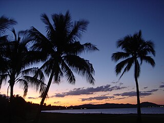
Magnetic Island is an island 8 kilometres (5 mi) offshore from the city of Townsville, Queensland, Australia. This 52 km2 (20.1 sq mi) mountainous island in Cleveland Bay has effectively become a suburb of Townsville, with 2,335 permanent residents. The island is accessible from Townsville Breakwater to Nelly Bay Harbour by ferry. There is a large 39.5 km2 (15.3 sq mi) National Park and bird sanctuary and walking tracks can be taken between the populated bays and to a number of tourist destinations such as the World War II forts.

Garbutt, Queensland Suburb of Townsville, Queensland, Australia

Garbutt is a suburb of Townsville in the City of Townsville, Queensland, Australia. In the 2016 census Garbutt had a population of 2,396 people.

Aitkenvale, Queensland Suburb of Townsville, Queensland, Australia

Aitkenvale is a suburb of Townsville in the City of Townsville, Queensland, Australia. In the 2016 census, Aitkenvale had a population of 4,790 people.

Mount Louisa, Queensland Suburb of Townsville, Queensland, Australia

Mount Louisa is a residential suburb in the City of Townsville, Queensland, Australia. The suburb contains the mountain Mount Louisa. In the 2016 census, Mount Louisa had a population of 8,825 people.

RAAF Base Townsville

RAAF Base Townsville is a Royal Australian Air Force (RAAF) air base located in Garbutt, 2 nautical miles west of Townsville in Queensland, Australia. It is the headquarters for No. 1 Wing Australian Air Force Cadets and, along with Lavarack Barracks, establishes Townsville as a key military centre. The base's airfield is shared with the Townsville Airport.

Douglas, Queensland Suburb of Townsville, Queensland, Australia

Douglas is a suburb of Townsville in the City of Townsville, Queensland, Australia. In the 2016 census, Douglas had a population of 7,744 people.

Nelly Bay, Queensland Suburb of Magnetic Island, Queensland, Australia

Nelly Bay is a town on Magnetic Island and a suburb of the City of Townsville, Queensland, Australia. In the 2016 census, Nelly Bay had a population of 1,196 people. A tourism hub on the island, it is especially significant as the site of the ferry terminal, which links it to Townsville.

Wulguru is an outer southern suburb of Townsville in the City of Townsville, Queensland, Australia. In the 2016 census, Wulguru had a population of 4,570 people.

Stuart is a rural coastal suburb in the City of Townsville, Queensland, Australia. In the 2016 census, Stuart had a population of 1,386 people.

Belgian Gardens, Queensland Suburb of Townsville, Queensland, Australia

Belgian Gardens is an inner coastal suburb of Townsville in the City of Townsville, Queensland, Australia. In the 2016 census Belgian Gardens had a population of 2,069 people.

South Townsville, Queensland Suburb of Townsville, Queensland, Australia

South Townsville is a coastal suburb of Townsville in the City of Townsville, Queensland, Australia. In the 2016 census, South Townsville had a population of 2,353 people.

Rowes Bay, Queensland Suburb of Townsville, Queensland, Australia

Rowes Bay is a suburb of Townsville in the City of Townsville, Queensland, Australia. In the 2016 census, Rowes Bay had a population of 573 people.

Bushland Beach, Queensland Suburb of Townsville, Queensland, Australia

Bushland Beach is a coastal suburb in the northern beaches area of Townsville in the City of Townsville, Queensland, Australia. In the 2016 census Bushland Beach had a population of 6,181 people.

Townsville City, Queensland Suburb of Townsville, Queensland, Australia

Townsville City is a coastal suburb at the centre of the City of Townsville, Queensland, Australia. In the 2016 census, the suburb of Townsville City had a population of 2,910 people.

Cape Cleveland, Queensland Suburb of Townsville, Queensland, Australia

Cape Cleveland is a rural locality in the City of Townsville, Queensland, Australia. In the 2016 census Cape Cleveland had a population of 155 people.

The Black River is a river located in North Queensland, Australia.

Mount St John Anti-Aircraft Battery Historic site in Queensland, Australia

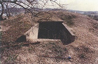
Mount St John Anti-Aircraft Battery is a heritage-listed fortification at 43 Toll Street, Mount St John, City of Townsville, Queensland, Australia. It was built between February and April 1942. It is also known as Y Station, 16 Heavy Anti-Aircraft Battery and No. 2 Station, Gun Station 393. It was added to the Queensland Heritage Register on 26 November 1999.

Town Common, Queensland Suburb of Townsville, Queensland, Australia

Town Common is a coastal suburb of Townsville in the City of Townsville, Queensland, Australia. In the 2016 census, Town Common had a population of 71 people.

Bohle, Queensland Suburb of Townsville, Queensland, Australia

Bohle is a northern suburb in the City of Townsville, Queensland, Australia. In the 2016 census, Bohle had a population of 85 people.

Heatley, Queensland Suburb of Townsville, Queensland, Australia

Heatley is a suburb in the City of Townsville, Queensland, Australia. In the 2016 census, Heatley had a population of 4,038 people.

References

  1. 1 2 3 Australian Bureau of Statistics (27 June 2017). "Mount St John (SSC)". 2016 Census QuickStats. Retrieved 20 October 2018. OOjs UI icon edit-ltr-progressive.svg
  2. 1 2 "Mount St John – suburb in City of Townsville (entry 44612)". Queensland Place Names. Queensland Government . Retrieved 29 December 2020.
  3. "Mount St John – mountain in City of Townsville (entry 32096)". Queensland Place Names. Queensland Government . Retrieved 29 December 2020.
  4. 1 2 3 4 "Queensland Globe". State of Queensland . Retrieved 19 January 2021.
  5. "Coral Coast Tourist Park". www.coralcoastpark.com.au. Archived from the original on 28 November 2020. Retrieved 19 January 2021.
  6. "Traditional Landowners - History and Heritage". Archived from the original on 27 March 2020. Retrieved 25 June 2020.
  7. "Y Station, 16 Heavy Anti-Aircraft Battery (entry 602084)". Queensland Heritage Register . Queensland Heritage Council. Retrieved 1 August 2014.
  8. "Y Station, 16 Heavy Anti-Aircraft Battery (entry 602084)". Queensland Heritage Register . Queensland Heritage Council. Retrieved 16 July 2013.
  9. 1 2 "Landmark Areas - Queensland". Queensland Open Data. Queensland Government. 18 November 2020. Archived from the original on 21 November 2020. Retrieved 21 October 2020.
  10. "Mount St John Wastewater Treatment Plant" (PDF). Townsville City Council . Archived (PDF) from the original on 5 April 2020. Retrieved 19 January 2021.