Mountain House, San Joaquin County, California

Last updated

Mountain House
10889945225 dcdae75ce8 c moutain house high (cropped).jpg
USA California location map.svg
Red pog.svg
Mountain House
Position in California.
Coordinates: 37°46′26″N121°32′39″W / 37.77389°N 121.54417°W / 37.77389; -121.54417
CountryUnited States
StateCalifornia
County San Joaquin
Government
   State senator Susan Eggman (D)
   Assemblymember Carlos Villapudua (D)
   U. S. rep. Josh Harder (D) [1]
Area
[2]
  Total3.192 sq mi (8.268 km2)
  Land3.192 sq mi (8.268 km2)
  Water0 sq mi (0 km2)  0%
Elevation
[3]
82 ft (25 m)
Population
  Total24,499
Time zone UTC−8 (Pacific Time Zone)
  Summer (DST) UTC−7 (PDT)
ZIP codes
95391
Area code 209
FIPS code 06-49582
GNIS feature IDs 1888888, 2628761
Website Official website
[3]

Mountain House is a planned community and census-designated place in San Joaquin County, California, United States. [4]

Contents

History

In 1849, Thomas Goodall erected a blue denim cloth tent to serve as a midway stopover for gold miners headed from San Francisco to the Sierra Nevada foothills via Altamont Pass. Goodall eventually built an adobe house at the eastern edge of the Diablo Range hills, calling it The Mountain House. Simon Zimmerman later acquired the stop and it became known as Zimmerman's Mountain House and became a well-known way station stop on the way to Stockton. The last remaining settlement buildings were leveled in 1940. [5]

In November 1994, the San Joaquin County Board of Supervisors officially approved the new community of Mountain House. In 1996, the master plan was approved. In August 2000, many of the documents controlling the development and growth of Mountain House were adopted and approved by the San Joaquin Board of Supervisors acting as the Mountain House Board of Directors. [6]

Mountain House was projected to be a small full-fledged city developed over a 30-year period by the Master Developer Trimark Communities. [7] The community covers 4,784 acres (1,936 ha) in San Joaquin County. The town was planned for 12 distinct neighborhoods including 10 family neighborhoods and two age-restricted neighborhoods, each organized around a center containing a neighborhood park, a K-8 school, and a small commercial area.

Construction began in 2001, but growth slowed down to about 50 permits per year because of the Great Recession in 2008. Development started again with increasing building permits and small land development projects in 2010 and 2011 and has continued at a high rate.

As of today, Mountain House includes the established villages of Wicklund, Bethany, Altamont, Questa, Hansen, Cordes, and College Park. Some 15,000 households or approximately 45,000–50,000 people are anticipated when Mountain House is fully completed. [8]

Milestones

Financial downturn

In November 2008, The New York Times reported that Mountain House was the "most underwater community in America" – the ZIP code with the highest amount of negative equity on its homes. [16] With home values decreasing across the nation, Mountain House was described as the worst-hit, with 90% of its homes worth less than the amount their owners owe in mortgages. [16] The average homeowner in Mountain House was reported to be $122,000 in debt. [16] Many local businesses in the 95391 ZIP code were closing because the homeowners were cutting back on their spending. [16]

CalPERS, an agency that manages pensions for California public employees, invested heavily in Mountain House beginning in 2005, purchasing approximately 9,000 residential lots from Shea Homes. By May 2010, the $1.12 billion investment by CalPERS had been reduced to 18% of that figure: $200 million. [17] Even though home values had dropped significantly, CalPERS determined that they would hold on to the investment, counting on a recovery of the housing market. [17]

Economic recovery

An uptick in economic performance at Mountain House was noted in September 2011 by Big Builder, a trade magazine of major land and housing development published by Hanley-Wood. [18]

Acknowledging the New York Times 2008 article that branded Mountain House as the most underwater community in America, the article chronicled a grassroots commitment by residents to keep their neighborhoods looking well-kept by mowing neglected lawns of homes in foreclosure, short sales or abandoned.

This community spirit helped persuade CalPERS to hold onto its Mountain House investment, despite the drawbacks of a 1994-vintage land plan, termed "out of sync with the realities of the post-housing crash world".[ This quote needs a citation ] Helping to balance the challenges of the land plan was the level of established infrastructure and homebuyers motivated by affordable pricing, proximity to job centers and traditional neighborhoods.

In April 2012, Big Builder again reported on the community, noting more robust first-quarter sales, new lot offers, and flexibility for semi-finished and raw land in future development. [19]

Geography

Mountain House lies on the foothills of the Diablo Range, and close to the Altamont Pass which is over 1,000 feet (300 m) in elevation. It is on the border of Alameda and Contra Costa counties. [20] According to the United States Census Bureau, the CDP covers an area of 3.2 square miles (8.3 km2), all of it land. The census definition of the area may not precisely correspond to local understanding of the area with the same name. The community is bisected by Mountain House Creek. [21] Mountain House Creek originates south of the Altamont Pass and Interstate 580, flowing northeasterly along and crossing under the interstate, then along Grant Line Road to the intersection with Mountain House Road at the historic Alameda County Mountain House. [22] The creek continues northeasterly through the residential communities of Mountain House before emptying into the Old River, a distributary of the San Joaquin River.

Climate

Climate data for Tracy Pumping Plant (1991–2020 normals, extremes 1955–present)
MonthJanFebMarAprMayJunJulAugSepOctNovDecYear
Record high °F (°C)74
(23)
77
(25)
88
(31)
97
(36)
107
(42)
112
(44)
112
(44)
111
(44)
112
(44)
102
(39)
85
(29)
74
(23)
112
(44)
Mean daily maximum °F (°C)56.3
(13.5)
61.9
(16.6)
67.4
(19.7)
73.2
(22.9)
80.2
(26.8)
88.1
(31.2)
93.3
(34.1)
92.5
(33.6)
88.8
(31.6)
79.1
(26.2)
65.6
(18.7)
56.6
(13.7)
75.2
(24.0)
Daily mean °F (°C)48.4
(9.1)
52.8
(11.6)
57.2
(14.0)
61.7
(16.5)
67.7
(19.8)
73.7
(23.2)
77.6
(25.3)
77.2
(25.1)
74.5
(23.6)
66.8
(19.3)
55.9
(13.3)
48.5
(9.2)
63.5
(17.5)
Mean daily minimum °F (°C)40.5
(4.7)
43.7
(6.5)
47.0
(8.3)
50.2
(10.1)
55.2
(12.9)
59.4
(15.2)
61.9
(16.6)
61.9
(16.6)
60.2
(15.7)
54.5
(12.5)
46.1
(7.8)
40.3
(4.6)
51.7
(10.9)
Record low °F (°C)18
(−8)
23
(−5)
25
(−4)
29
(−2)
34
(1)
37
(3)
44
(7)
42
(6)
40
(4)
30
(−1)
24
(−4)
17
(−8)
17
(−8)
Average precipitation inches (mm)2.51
(64)
2.32
(59)
1.60
(41)
0.84
(21)
0.52
(13)
0.13
(3.3)
0.00
(0.00)
0.01
(0.25)
0.08
(2.0)
0.67
(17)
1.32
(34)
2.37
(60)
12.37
(314)
Average snowfall inches (cm)0.0
(0.0)
0.0
(0.0)
0.0
(0.0)
0.0
(0.0)
0.0
(0.0)
0.0
(0.0)
0.0
(0.0)
0.0
(0.0)
0.0
(0.0)
0.0
(0.0)
0.0
(0.0)
0.0
(0.0)
0.0
(0.0)
Average precipitation days (≥ 0.01 in)12.99.68.44.82.70.90.00.30.52.56.711.861.1
Average snowy days (≥ 0.1 in)0.00.00.00.00.00.00.00.00.00.00.00.00.0
Source: NOAA [23] [24]

Demographics

The 2010 Census reported that Mountain House had a population of 9,675. The 2020 Census reported that Mountain House had a population of 24,499, an increase of 153% over the decade.

In 2020, 42% of the population was age 18 or younger and 6% were above age 65.

In 2020, Mountain House grew increasingly diverse with a population that is now 54.6% Asian, 18.7% Non-Hispanic White, 13% Hispanic and 7.3% black, and 9.5% two or more races; 45% of the population have a bachelor's degree or higher.

There were 5,948 households in 2020 and the median household income was $154,347.

Government

The Mountain House Community Services District (MHCSD) is the local government and is governed since 2008 by 5 elected board members who live in the community (similar to the city council) and a general manager (similar to the city manager.) Before 2008, the MHCSD was governed by the San Joaquin County Supervisors.

The MHCSD has 18 primary powers which include providing police (current contract with San Joaquin Sheriffs), fire (current contract with French Camp Fire), library services, water, sewer, garbage (current contract with West Valley Disposal), public recreation, road maintenance, street lights, graffiti abatement, CC&R (Master Restrictions) enforcement, telecommunication services, converting utilities to underground, transportation services, flood control protection, wildlife habitat mitigation, pest and weed abatement, and dissemination of information. [25] Unlike incorporated cities, the MHCSD does not have power over land use or economic development.

The general manager is Steve Pinkerton, who was hired in August 2019. [26]

Education

Students in Mountain House are served by the Lammersville Joint Unified School District. [27]

Mountain House Elementary School is a K–8 school in unincorporated Alameda County, run by the independent Mountain House Elementary School District. [28]

Mountain House High School opened in 2014. [29]

The south campus of the San Joaquin Delta College opened in 2020, and is located in the College Park Village of Mountain House. [30]

Media

Mountain House Matters is a monthly publication about Mountain House, its people and activities.[ citation needed ]

The Tracy Press is a weekly newspaper that covers Tracy and Mountain House.

Infrastructure

Transportation

Public transportation

The nearest railway station is in Tracy, operated by Altamont Corridor Express (ACE). Livermore Amador Valley Transit Authority provides bus service to Hacienda Business Park and the Dublin/Pleasanton BART station. [31] San Joaquin RTD provides van service to the Tracy Transit Center. [32]

Major highways

Interstate 205 serves as the closest major highway to Mountain House, which runs just south of the community and is connected via an interchange at Mountain House Parkway (exit 2).

Related Research Articles

<span class="mw-page-title-main">Sacramento County, California</span> County in California, United States

Sacramento County is a county located in the U.S. state of California. As of the 2020 census, the population was 1,585,055. Its county seat is Sacramento, which has been the state capital of California since 1854.

<span class="mw-page-title-main">Alameda County, California</span> County in California, United States

Alameda County is a county located in the U.S. state of California. As of the 2020 census, the population was 1,682,353, making it the 7th-most populous county in the state and 21st most populous nationally. The county seat is Oakland. Alameda County is in the San Francisco Bay Area, occupying much of the East Bay region.

<span class="mw-page-title-main">Kern County, California</span> County in California, United States

Kern County is a county located in the U.S. state of California. As of the 2020 census, the population was 909,235. Its county seat is Bakersfield.

<span class="mw-page-title-main">San Bernardino County, California</span> County in southern California, United States

San Bernardino County, officially the County of San Bernardino, is a county located in the southern portion of the U.S. state of California, and is located within the Inland Empire area. As of the 2020 U.S. Census, the population was 2,181,654, making it the fifth-most populous county in California and the 14th-most populous in the United States. The county seat is San Bernardino.

<span class="mw-page-title-main">Madera County, California</span> County in California, United States

Madera County, officially the County of Madera, is located at the geographic center of the U.S. state of California. It features a varied landscape, encompassing the eastern San Joaquin Valley and the central Sierra Nevada, with Madera serving as the county seat. Established in 1893 from part of Fresno County, Madera County reported a population of 156,255 in the 2020 census.

<span class="mw-page-title-main">San Joaquin County, California</span> County in California, United States

San Joaquin County, officially the County of San Joaquin, is a county located in the U.S. state of California. As of the 2020 census, the population was 779,233. The county seat is Stockton.

<span class="mw-page-title-main">San Mateo County, California</span> County in California, United States

San Mateo County, officially the County of San Mateo, is a county located in the U.S. state of California. As of the 2020 census, the population was 764,442. Redwood City is the county seat, and the third most populated city following Daly City and San Mateo. San Mateo County is included in the San Francisco–Oakland–Berkeley, CA MSA, Silicon Valley, and is part of the San Francisco Bay Area, the nine counties bordering San Francisco Bay. It covers most of the San Francisco Peninsula. San Francisco International Airport is located in the northeastern area of the county and is approximately 7 miles (11 km) south of the city and county limits of San Francisco, even though the airport itself is assigned a San Francisco postal address. The county's built-up areas are mostly suburban, and are home to many corporate campuses.

<span class="mw-page-title-main">Stanislaus County, California</span> County in California, United States

Stanislaus County is a county located in the San Joaquin Valley of the U.S. state of California. As of 2023, its estimated population is 564,404. The county seat is Modesto.

<span class="mw-page-title-main">Stockton, California</span> City in California, U.S.

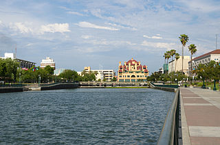
Stockton is a city in and the county seat of San Joaquin County in the Central Valley of the U.S. state of California. Stockton is the most populous city in the county, the 11th-most populous city in California and the 58th-most populous city in the United States. Stockton's population in 2020 was 320,804. It was named an All-America City in 1999, 2004, 2015, and again in 2017 and 2018. The city is located on the San Joaquin River in the northern San Joaquin Valley. It lies at the southeastern corner of a large inland river delta that isolates it from other nearby cities such as Sacramento and those of the San Francisco Bay Area.

<span class="mw-page-title-main">Brentwood, California</span> City in California, United States

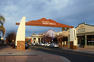
Brentwood is a city in Contra Costa County, California, United States. It is located in the East Bay region of the San Francisco Bay Area. The population is 66,854 as of 2022, an increase of 287% from 23,302 at the 2000 census.

<span class="mw-page-title-main">Lathrop, California</span> City in the United States

Lathrop is a city located 10 miles (16 km) south of Stockton in San Joaquin County, California, United States. The 2020 census reported that Lathrop's population was 28,701. The city is located in Northern California at the intersection of Interstate 5 and California State Route 120, in the San Joaquin Valley.

<span class="mw-page-title-main">Tracy, California</span> City in California, United States

Tracy is the second most populated city in San Joaquin County, California, United States. The population was 93,000 at the 2020 census. Tracy is located inside a geographic triangle formed by Interstate 205 on the north side of the city, Interstate 5 to the east, and Interstate 580 to the southwest.

<span class="mw-page-title-main">Interstate 205 (California)</span> Interstate highway in California

Interstate 205 (I-205) is an east–west auxiliary Interstate Highway in the San Joaquin Valley in Northern California. It runs from I-5 west to I-580. Along with those highways, I-205 forms the north side of a triangle around the city of Tracy. The route provides access from the San Francisco Bay Area to the northern San Joaquin Valley.

Otay Mesa is a community in the southern exclave of the city of San Diego, just north of the U.S.–Mexico border.

Lammersville Unified School District is a school district in Mountain House, California and serves the area of Mountain House and rural Tracy.

<span class="mw-page-title-main">Mountain House, Alameda County, California</span> Unincorporated community in California, United States

Mountain House was a historic waystop for forty-niners halfway from San Francisco to the Sierra Nevada gold country. Today it is an unincorporated community in Alameda County, California, United States. It is located 12 miles (19 km) east-northeast of Livermore, and 6 miles (9.7 km) east of the Altamont Pass, historically the Livermore Pass, at an altitude of 207 feet (63 m), between the California Aqueduct and the Delta-Mendota Canal. San Joaquin County's Mountain House borrowed the name of the historic Mountain House and is located two miles (3 km) to the northeast further downstream on Mountain House Creek.

River Islands at Lathrop is a planned community on a 4,800-acre site in the Sacramento-San Joaquin River Delta in Lathrop, California, United States. As of 2018, approximately 800 homes of the first-phase of 4,284 houses had been built.

Lammersville Unified School district (LUSD) is a pre-kindergarten through twelfth grade unified school district in Mountain House, California, which serves the area west of Tracy and parts of Alameda County. The district was created when majority of voters in the Lammersville and Mountain House area passed a measure to separate from Tracy Unified School District in a special election on June 8, 2010. It became an independent school district on July 1, 2011.

<span class="mw-page-title-main">Valley Link</span> Proposed commuter rail service in northern California

Valley Link is a proposed 26-mile-long (42 km) commuter rail service in Northern California, which seeks to connect the rapid transit Bay Area Rapid Transit (BART) system in the San Francisco Bay Area with the northern San Joaquin Valley via the Tri-Valley region. Since 1997, BART's Blue Line's eastern terminus is at Dublin/Pleasanton station on the border of Dublin and Pleasanton. Valley Link seeks to extend rail service east from here into the northern San Joaquin Valley over Altamont Pass and to help alleviate traffic congestion and reducing greenhouse gas emissions on Interstate 580 (I-580). The project resulted from various failed proposals to extend the Blue Line east to Livermore.

<span class="mw-page-title-main">Empire Tract</span> Island in California

The Empire Tract is an island in the Sacramento–San Joaquin River Delta in San Joaquin County, California, United States. It has been used for agriculture since the 1800s; in the early 20th century it was used to plant potatoes, and United States president Herbert Hoover operated a beet farm there. In the 1960s, natural gas deposits were discovered beneath the island. In 1936, it was connected to the mainland by the Eight Mile Road Bridge, across King Island. As with many islands in the Delta, the Empire Tract has experienced considerable subsidence, and is well below sea level.

References

  1. "California's 9th Congressional District - Representatives & District Map". Civic Impulse, LLC. Retrieved October 7, 2014.
  2. "2010 Census U.S. Gazetteer Files – Places – California". United States Census Bureau.
  3. 1 2 "Mountain House Census Designated Place". Geographic Names Information System . United States Geological Survey, United States Department of the Interior.
  4. 1 2 "Mountain House CDP QuickFacts". United States Census Bureau.
  5. History of Tracy, California with Biographical Sketches. Los Angeles: Historic Record Company. 1923.
  6. King, John. "This California city was started from scratch 20 years ago. Here's how it turned out". San Francisco Chronicle. Retrieved March 8, 2024.
  7. Brinkley, Leslie (August 5, 2004). "New Bay Area Suburb". ABC 7 News. Archived from the original on October 30, 2004. Retrieved August 5, 2004.
  8. "Chapter 3: Land Use". Mountain House Master Plan. pp. 3.2 and 3.12. Retrieved April 7, 2013.
  9. Johnson, Zachary K (September 26, 2007). "Delta College to extend south". Recordnet.com. Local Media Group, Inc. Retrieved January 13, 2016.
  10. Streitfeld, David (November 11, 2008). "A Town Drowns in Debt as Home Values Plunge". The New York Times. ISSN   0362-4331 . Retrieved July 19, 2022.
  11. "Letter to Mountain House community" (PDF). Mountain House Community Services District. Archived from the original (PDF) on June 17, 2015. Retrieved June 17, 2015.
  12. Stevens, Matt (June 18, 2015). "Master-planned community at risk of losing all water within days". Los Angeles Times .
  13. Mountain, House (September 25, 2018). "Mountain House breaks ground on town hall complex". Tracy Press.
  14. "'Lots of things happening': San Joaquin County community opens large retail center". KCRA. January 13, 2022. Retrieved November 22, 2022.
  15. "'Mountain House voters make it clear: SJ County getting 8th City'". Manteca Bulletin. March 6, 2024. Retrieved March 6, 2024.
  16. 1 2 3 4 Streitfeld, David (November 10, 2008). "A Town Drowns in Debt as Home Values Plunge". The New York Times. Retrieved August 3, 2011.
  17. 1 2 Kasler, Dale (May 6, 2010). "Fund Held Underwater: CalPERS to wait for Mountain House rebound: City hardest hit in nation by real estate slump". The Modesto Bee. Archived from the original on March 20, 2012. Retrieved August 3, 2011.
  18. McManus, John; Yaussi, Sarah (September 2011). "Mountain House? living proof that it's possible to rebuild the American Dream out of the stuff of nightmares". Big Builder. Retrieved April 7, 2013.
  19. Caulfied, John (April 19, 2012). "Long Climb Pays Off for Builders at NoCal's Mountain House". BUILDER Online. Washington, D.C.: Hanley Wood Media. Retrieved April 7, 2013.
  20. Wyatt, Dennis (May 15, 2021). "Mountain House didn't exist 20 years ago, today it is bigger than City of Ripon". Manteca/Ripon Bulletin. Retrieved February 27, 2022.
  21. "Mountain House Creek". Geographic Names Information System . United States Geological Survey, United States Department of the Interior.
  22. "Mountain House". Geographic Names Information System . United States Geological Survey, United States Department of the Interior.
  23. "NOWData - NOAA Online Weather Data". National Oceanic and Atmospheric Administration. Retrieved March 22, 2024.
  24. "Summary of Monthly Normals 1991-2020". National Oceanic and Atmospheric Administration. Retrieved March 22, 2024.
  25. "Five elected in first race for Mountain House board", Stockton Record, November 5, 2008
  26. "Board of Directors | Mountain House Community Services District - Mountain House, California". Archived from the original on March 5, 2021. Retrieved March 6, 2021.
  27. "Voters approve Lammersville school unification". Tracy press. June 8, 2010. Retrieved June 8, 2010.
  28. "Welcome to Mountain House Elementary School | Mountain House Elementary School District". www.mtnhouse.k12.ca.us. Retrieved August 8, 2019.
  29. Young, Kevin (February 24, 2011). "Mountain House inches toward high school". Tracy press. Retrieved February 24, 2011.
  30. Lafferty, Justin (August 17, 2009). "Delta College in Mountain House". Tracy press. Retrieved August 17, 2009.
  31. "Mountain House commuters have transportation option", The Record (Stockton), February 4, 2006
  32. "Tracer map" (PDF). Archived from the original (PDF) on August 9, 2017. Retrieved August 8, 2017.

Official website