Mpofu Nature Reserve

Last updated

Mpofu Nature Reserve
South Africa Eastern Cape relief location map.svg
Red pog.svg
Location within Eastern Cape
Location Eastern Cape, South Africa
Nearest city Balfour
Coordinates 32°37′16″S26°35′28″E / 32.621°S 26.591°E / -32.621; 26.591 [1]
Area7,500 ha (19,000 acres)
Governing body Eastern Cape Parks
www.ecparks.co.za/parks-reserves/mpofu/index.html

Mpofu Nature Reserve is a nature reserve in the Amatole district of the Eastern Cape Province, South Africa that is managed by Eastern Cape Parks.

Contents

Mpofu is situated roughly 25 km (16 miles) northwest of Fort Beaufort and 20 km (12 miles) west of Balfour. It lies on the escarpment and lower valleys of the Katberg Mountains and covers 7,500 ha (19,000 acres) with altitudes varying from 550 to 1,384 metres (1,804 to 4,541 ft). The reserve was established in 1985 from land purchased from families who were descended from the 1820 settlers.

Geography and Climate

Mpofu occupies the valleys and escarpments between the Katberg and Amatole mountain ranges. Some areas of the reserve are on steep terrain as a result. The reserve experiences its rainy season between November and March and summers are hot and humid. Autumn and winter are mainly dry and cool, and snowfalls occasionally occur on the surrounding mountain ranges. The nature reserve, like the rest of the Eastern Cape, is a malaria-free zone. [2]

Vegetation

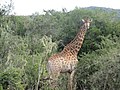
The vegetation of the reserve comprises Grassland, Forest, and Albany Thicket biomes. Many species of flora found in these biomes are endemic to South Africa. Bush encroachment by Acacia karoo is currently a threat to the biodiversity of Mpofu nature reserve.

Wildlife

There is a large variety of mammals found in the reserve including the endangered White Rhino. Other species include Burchell's zebra, Giraffe, Bushbuck, African Buffalo, Eland, and Black-backed jackal. The bird life is also diverse, and there are many insect and reptile species found in the reserve.

[3]

Activities

The reserve hosts several hiking and walking trails, including the Katberg hiking trail. There is also bird watching, educational tours and game drives available. Nearby attractions include the mountain village, Hogsback, and Khoisan rock art in Waylands. [4]

Mountain Passes

There are three passes which traverse between the Mpofu Nature reserve and the Fort Fordyce Nature Reserves:

Blinkwater Pass

The Blinkwater Pass is a 19 kilometre gravel pass which goes northward up the Amathola escarpment across the reserve. The entrance to this pass is free, however, there are gated control points. This is the longest of the three local passes that traverse the Mpofu and Fort Fordyce Nature Reserves. [5]

Fullers Hoek Pass

Fuller's Hoek Pass lies off the R67 northwest of Fort Beaufort within the Fort Fordyce Nature Reserve. It is 8 km in length and has many curves and bends. The road passes rare afromontane forest. Snow often falls in this area during the winter. [6]

Bosnek Pass

The Bosnek pass is a 9 km gravel pass. The altitude variance is 418 metres and the summit is at a height of 1121 metres. The road is engineered with a 1:8 gradient. The road is subject to washaways and corrugation. [7]

Mythology

The Blinkwater Monster is said to visit the reserve regularly. The Blinkwater Monster refers to a fossil of Pareiasaurus serridens, a mammal-like reptile, which was named and discovered by Andrew Geddes Bain, a geologist and palaeontologist who discovered many fossils in the areas surrounding the reserve. He was awarded £200 by the British government in 1845 for his research. [8]

See also

Notes

  1. "Mpofu Game Reserve Provincial Nature Reserve". protectedplanet.net. Archived from the original on 3 June 2012. Retrieved 24 September 2011.
  2. "Mpofu Nature Reserve Eastern Cape Province, South Africa". Archived from the original on 8 July 2007. Retrieved 15 January 2018.[ title missing ]
  3. Tony Pinchuck, Barbara McCrea, Donald Reid. South Africa. Rough Guides, 2002. pg 409-410
  4. "Mpofu Nature Reserve, Eastern Cape". www.sa-venues.com. Retrieved 15 January 2018.
  5. "Blinkwater Pass (MR0644) - Mountain Passes South Africa". www.mountainpassessouthafrica.co.za. Retrieved 15 January 2018.
  6. "Fuller's Hoek Pass in Fort Beaufort, Eastern Cape". www.sa-venues.com. Retrieved 15 January 2018.
  7. "Bosnek (P0646) - Mountain Passes South Africa". mountainpassessouthafrica.co.za. Retrieved 17 January 2018.
  8. "Latest News! 21st July, 2016 - Mountain Passes South Africa". www.mountainpassessouthafrica.co.za. Retrieved 15 January 2018.

Related Research Articles

<span class="mw-page-title-main">Andrew Geddes Bain</span>

Andrew Geddes Bain, was a South African geologist, road engineer, palaeontologist and explorer.

<span class="mw-page-title-main">Drakensberg</span> Mountain range in South Africa

The Drakensberg is the eastern portion of the Great Escarpment, which encloses the central Southern African plateau. The Great Escarpment reaches its greatest elevation – 2,000 to 3,482 metres within the border region of South Africa and Lesotho.

<span class="mw-page-title-main">Ithala Game Reserve</span>

Ithala Game Reserve is situated in 290 km2 of rugged, mountainous thornveld, about 400 km north of Durban, in northern KwaZulu-Natal, South Africa. It is one of the youngest game parks in South Africa. The altitude varies from 400 m along the Phongolo River to 1,450 m along the Ngotshe Mountain escarpment. The reserve consequently encompasses a great variation of terrain, from densely vegetated river valleys and lowveld to sourveld, high-lying grassland plateaus, mountain ridges and cliff faces.

<span class="mw-page-title-main">Karoo</span> Semi-desert region in South Africa

The Karoo is a semi-desert natural region of South Africa. No exact definition of what constitutes the Karoo is available, so its extent is also not precisely defined. The Karoo is partly defined by its topography, geology and climate, and above all, its low rainfall, arid air, cloudless skies, and extremes of heat and cold. The Karoo also hosted a well-preserved ecosystem hundreds of million years ago which is now represented by many fossils.

Harrismith is a large town in the Free State province of South Africa. It was named for Sir Harry Smith, a 19th-century British governor and high commissioner of the Cape Colony. It is situated by the Wilge River, alongside the N3 highway, about midway between Johannesburg, about 275 km to the north-west, and Durban to the southeast. The town is located at the junction of the N5 highway, which continues westward towards the provincial capital Bloemfontein, some 340 km to the south-west. This important crossroads in South Africa's land trade routes is surrounded by mesas and buttes. It is located at the base of one of these called Platberg.

<span class="mw-page-title-main">Knysna–Amatole montane forests</span> Ecoregion of the tropical and subtropical moist broadleaf forests biome in South Africa

The Knysna–Amatole montane forests ecoregion, of the tropical and subtropical moist broadleaf forests biome, is in South Africa. It covers an Afromontane area of 3,100 square kilometres (1,200 sq mi) in the Eastern Cape and Western Cape provinces.

<span class="mw-page-title-main">Amathole Mountains</span> Mountain range in South Africa

Amatola, Amatole or Amathole are a range of densely forested mountains, situated in the Eastern Cape province of South Africa. The word Amathole means ‘calves’ in Xhosa, and Amathole District Municipality, which lies to the south, is named after these mountains.

<span class="mw-page-title-main">Karoo National Park</span> Wildlife reserve in the Great Karoo area of the Western Cape, South Africa near Beaufort West

The Karoo National Park is a wildlife reserve in the Great Karoo area of the Western Cape, South Africa near Beaufort West. This semi-desert area covers an area of 750 square kilometres (290 sq mi). The Nuweveld portion of the Great Escarpment runs through the Park. It is therefore partly in the Lower Karoo, at about 850 m above sea level, and partly in the Upper Karoo at over 1300 m altitude.

<span class="mw-page-title-main">Hottentots Holland Mountains</span> Mountain range in the Western Cape, South Africa.

The Hottentots Holland Mountains are part of the Cape Fold Belt in the Western Cape, South Africa. The mountain range forms a barrier between the Cape Town metropolitan area and the southern Overberg coast.

<span class="mw-page-title-main">Wildlife of Zimbabwe</span> Native fauna and flora of Zimbabwe

The wildlife of Zimbabwe occurs foremost in remote or rugged terrain, in national parks and private wildlife ranches, in miombo woodlands and thorny acacia or kopje. The prominent wild fauna includes African buffalo, African bush elephant, black rhinoceros, southern giraffe, African leopard, lion, plains zebra, and several antelope species.

Eastern Cape Parks are the national parks, marine protected areas, nature reserves and other nature conservation areas in the Eastern Cape province of South Africa. Eastern Cape Parks and Tourism Agency (ECPTA) is the governmental organisation responsible for maintaining wilderness areas and public nature reserves in the Eastern Cape, based in East London.

The Hluleka Nature Reserve is a nature reserve in Eastern Cape Province, South Africa that is managed by Eastern Cape Parks, it is about 90 km to the south-east of Mthatha, and 30 kilometres south of Port St Johns. The size of the reserve is 772 ha

The QwaQwa National Park is part of the Golden Gate Highlands National Park and the Maloti-Drakensberg Park and comprises the former Bantustan (homeland) of QwaQwa. It is approximately 60 km from Harrismith on the Golden Gate Road (R712) and formed an integral part of the Highlands Treasure Route.

<span class="mw-page-title-main">Mkhambathi Nature Reserve</span> Coastal nature reserve at Lusikisiki in the Eastern Cape, South Africa

Mkhambathi Nature Reserve is a protected area at Lusikisiki in the Eastern Cape, South Africa. It is 7,720 hectares, with the Pondoland Marine Protected Area off its coastal edge. The reserve is located in the Pondoland Centre of Plant Endemism and the greater Maputaland–Pondoland–Albany Hotspot, and is covered in open grassland, dotted with patches of indigenous forest, swamp forests and flanked by the forested ravines of the Msikaba and Mtentu rivers.

Tshukudu Private Game Reserve, is situated next to the Kruger Park, near Hoedspruit, Limpopo province, South Africa. The name "Tshukudu" means "rhino" in Sotho. Tshukudu has been a family owned reserve since 1980.

<span class="mw-page-title-main">Kat River</span> River in the Eastern Cape, South Africa

The Kat River is a tributary of the Great Fish River, that drains the southern slopes of the Winterberg in the Eastern Cape Province, South Africa.

<span class="mw-page-title-main">Philip Herd Nature Reserve</span> Nature reserve in South Africa

Philip Herd Nature Reserve is a nature reserve within the UNESCO Vhembe Biosphere Reserve in the Vhembe District of Limpopo Province, South Africa. The reserve is located east of the town of Musina on the Limpopo River which forms the border between South Africa and Zimbabwe. It covers an area of 12,000 hectares (Ha), of which 6,616.42 Ha is a declared protected area in terms of South Africa's National Environmental Management Act: Protected Areas Act of 2003. The reserve conserves a critically biodiverse area of Limpopo Ridge Bushveld and 1.5% of the Nzhelele River catchment, which forms part of the Limpopo Water Management Area (WMA) established in terms of South Africa's National Water Act of 1998. The reserve operates under the brand name, The Herd Reserve.

Kap River Nature Reserve is a nature reserve that lies between the confluence of the Kap River and the southern bank of the Great Fish River near Port Alfred. Neighbouring it is the Great Fish River Mouth Wetland Nature Reserve.

References