
Plettenberg Bay, nicknamed Plett, is the primary town of the Bitou Local Municipality in the Western Cape Province of South Africa. As of the census of 2001, there were 29,149 population. It was originally named Bahia Formosa by early Portuguese explorers and lies on South Africa's Garden Route 210 km from Port Elizabeth and about 600 km from Cape Town.

Knysna is a town with 76,150 inhabitants in the Western Cape province of South Africa. It is one of the destinations on the loosely defined Garden Route tourist route. It is situated 60 kilometres east of the city of George on the N2 highway, and 33 kilometres west of the Plettenberg Bay on the same road.
The Garden Route is a 300-kilometre (190 mi) stretch of the south-eastern coast of South Africa which extends from Witsand in the Western Cape to the border of Tsitsikamma Storms River in the Eastern Cape. The name comes from the verdant and ecologically diverse vegetation encountered here and the numerous estuaries and lakes dotted along the coast. It includes towns such as Witsand, Heidelberg, Riversdale, Stilbaai, Albertinia, Gouritsmond, Knysna, Plettenberg Bay, Mossel Bay, Oudtshoorn, Great Brak River, Little Brak River, Wilderness, Sedgefield and Nature's Valley; with George, the Garden Route's largest city and main administrative centre.

The N2 is a national route in South Africa that runs from Cape Town through George, Gqeberha, East London, Mthatha, Port Shepstone and Durban to Ermelo. It is the main highway along the Indian Ocean coast of the country. Its current length of 2,255 kilometres (1,401 mi) makes it the longest numbered route in South Africa.

George is the second largest city in the Western Cape province of South Africa. The city is a popular holiday and conference centre, as well as the administrative and commercial hub and the seat of the Garden Route District Municipality. It is named after the British Monarch George III.
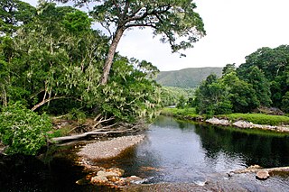
The Knysna–Amatole montane forests ecoregion, of the tropical and subtropical moist broadleaf forests biome, is in South Africa. It covers an Afromontane area of 3,100 square kilometres (1,200 sq mi) in the Eastern Cape and Western Cape provinces.
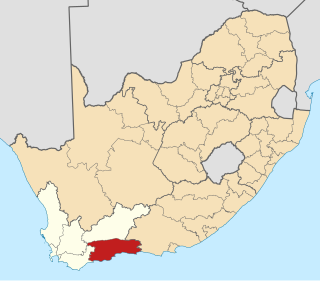
The Garden Route District Municipality, formerly known as the Eden District Municipality, is a district municipality located in the Western Cape province of South Africa. Its municipality code is DC4.

The Tsitsikamma National Park is a protected area on the Garden Route, Western Cape and Eastern Cape, South Africa. It is a coastal reserve well known for its indigenous forests, dramatic coastline, and the Otter Trail. On 6 March 2009 it was amalgamated with the Wilderness National Park and various other areas of land to form the Garden Route National Park.
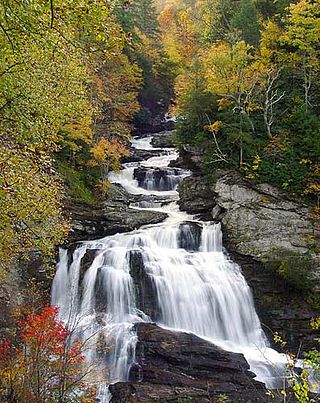
The Nantahala National Forest is the largest of the four national forests in North Carolina, lying in the mountains and valleys of western North Carolina. The Nantahala is the second wettest region in the country, after the Pacific Northwest. Due to its environmental importance and historical ties with the Cherokee, the forest was officially established on January 29, 1920, by President Woodrow Wilson. The word "Nantahala" is a Cherokee derived, meaning "Land of the Noonday Sun." In some spots, the sun reaches the floors of the deep gorges of the forest only when it is high overhead at midday. This was part of the homeland of the historic Cherokee and their indigenous ancestors, who have occupied the region for thousands of years. The Nantahala River runs through it.

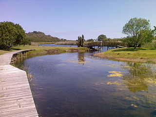
Nature's Valley is a holiday resort and small village on the Garden Route along the southern Cape coast of South Africa. Nature's Valley lies between the Salt River, the foothills of the Tsitsikamma Mountains, the Indian Ocean and the Groot River lagoon. Nature's Valley has a balmy climate and is surrounded by the de Vasselot Nature Reserve which is part of the Tsitsikamma Park, and in turn part of the Garden Route National Park.

The Tsitsikamma mountains form an east-west mountain range located in the Garden Route region of the southern South African coast in the Western Cape and Eastern Cape provinces. Tsitsikamma means 'place of much water' in the Khoekhoe language.
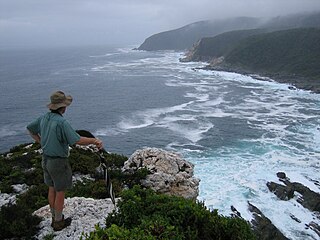
The Otter Trail is a hiking trail along the Garden Route coast of South Africa and is named for the Cape clawless otter which occurs in this region. This trail is widely regarded as one of the finest in the world and stretches from Storms River Mouth in the east to Nature's Valley in the west, is 26 km long as the crow flies and 44 km as the hiker walks. Walking the trail takes 5 days, and the 4 nights are spent in comfortable huts with superb views. The route is located entirely within the Tsitsikamma National Park, which protects an 80 km long strip of coastal mountains, forest and beaches.
Eastern Cape Parks are the national parks, marine protected areas, nature reserves and other nature conservation areas in the Eastern Cape province of South Africa. Eastern Cape Parks and Tourism Agency (ECPTA) is the governmental organisation responsible for maintaining wilderness areas and public nature reserves in the Eastern Cape, based in East London.
Wilderness National Park, also called the Wilderness Section, is located around the seaside town of Wilderness between the larger towns of George and Knysna, in the Western Cape. It is a protected area of South Africa forming part of the Garden Route National Park.

The Bloukrans River is a short river located in the Tsitsikamma region of the Garden Route, South Africa. It is located on the border between the Western Cape and Eastern Cape provinces. The river mouth is located east of Nature's Valley, the Bloukrans Bridge spans the river near the mouth and the Bloukrans Pass is close by. The river originates near Peak Formosa in the Plettenberg Bay region.

Touws River is a small railway town of 8,126 people in the Western Cape province of South Africa. It is located on the river of the same name, about 160 kilometres (100 mi) north-east of Cape Town. The Touwsrivier CPV Solar Project is located just outside of the town and supplies 50 MW to the national electrical grid.

Southern Afrotemperate Forest is a kind of tall, shady, multilayered indigenous South African forest. This is the main forest-type in the south-western part of South Africa, naturally extending from the Cape Peninsula in the west, as far as Port Elizabeth in the east. In this range, it usually occurs in small forest pockets, surrounded by fynbos vegetation.

The Salt River aka Soutrivier of the Garden Route arises in the Tsitsikamma Mountains between Knysna and Port Elizabeth in South Africa, and mouths into the Indian Ocean just west of Nature's Valley.

Seven Passes Road is the oldest direct road link between George and Knysna in Western Cape, South Africa. The road which traverses seven passes was engineered by Thomas Charles John Bain and Adam de Smidt. It was completed around 1883 and is situated just south of the Outeniqua Mountains.


