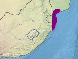
This ecoregion covers globally all the humid subtropical climate zones of Africa (the latter being located almost exclusively in South Africa), an area of 274,136km2 (105,845sqmi). It forms a broad coastal strip extending from the extreme south of Mozambique and north-east of Mpumalanga to the east of Eastern Cape Province in South Africa, including the Wild Coast. It also includes eastern Swaziland and borders southern and eastern Lesotho. It consists of three regions more or less biologically close but each with its own characteristics. Maputaland (also known as Tongaland) refers to the southern part of Mozambique, Swaziland and northern KwaZulu-Natal, Pondoland includes central and southern KwaZulu-Natal, and Albany is the eastern part of Eastern Cape.[2]
The terrain in this region is complex, providing a great diversity of landscapes with varied reliefs. It encompasses the southeast of the Great Escarpment and down to the edge of the Indian Ocean. As a result, this ecoregion includes much of the Drakensberg range, especially in the south and centre of the area. One of the best-watered areas in South Africa, a large part of the area receives on average between 750 and 1,000mm (30 and 39in) per year and the Kwazulu-Natal coasts as well as parts of the Drakensberg exceed the annual 1,000mm (39in).[3] The northern part of the area consists mainly of medium and lowland plains with areas of ancient sand dunes, while the southern part has more rugged terrain with many cliffs cut by multiple streams. Inland, there are several ranges of mountain which include Sneeuberge, Winterberg, Amathole Mountains, Ngeli Range, Lebombo Mountains and Ngoye Range.[4]
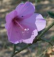
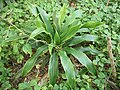
The Maputaland-Pondoland-Albany area supports a very high biodiversity, both animal and plant. With nearly 8100 vascular plants species and 2000 endemic plant species, it is the second richest area in Africa in terms of plant diversity, after the Cape Floristic Region. The Albany region also has a great diversity of succulent plants, notably arborescent plants, differing from the leafy succulent species of the Karoo desert. The vegetation cover is mainly composed of forests, shrubland, bushveld and meadows. About 80% of the remaining forests of South Africa occur in this region, and nearly 600 species of trees are represented here, the highest diversity of any temperate forest in the world. Among the large number of plants in this ecoregion, about 1900 are endemic.[4] There is also an endemic family, that of Rhynchocalycaceae, which has only one species: Rhynchocalyx lawsonioides. Many plants present in this hotspot were subsequently widely used as ornamental or medicinal plants; examples include Strelitzia reginae and nicolai, Clivia miniata, Kniphofia or the extremely rare Sandersonia aurantiaca. Aloe ferox is widely used for its sap with healing properties.
Although the hotspot was originally envisaged as referring to the wide diversity of vascular plant species, the pattern of plant endemism is matched by numerous endemic vertebrates. The degree of endemism among plants in this hotspot is 23.5% whereas the degree of endemism among vertebrates is 5.1% and near-endemism 4.9%. If the area of the hotspot was redefined as the "Greater Maputaland-Pondoland-Albany" area, an increase of 73%, to include the Great Escarpment area, the vertebrate endemism would total 146 species (19 freshwater fishes, 29 amphibians, 75 reptiles, 15 birds and 8 mammals), a figure 135% higher than the 62 vertebrate species for the MPA as presently defined.[5]
Most of the endemic vertebrates in the ecoregion inhabit the forests and grasslands, and many have niche habitat requirements such as rocky outcrops or marshy areas within these larger biomes; the Sloggett's vlei rat and the Natal red rock hare are quite widespread in the area while the woodbush legless skink and the robust golden mole have narrower habitat requirements.[6]
A White Rhino emerging from a mud bath in Hluhluwe-Umfolozi Reserve
Animal diversity is lower, with fairly low endemism. 194 species of mammals are counted there, of which only 4 are endemic: Red bush squirrel (Paraxerus palliates), four-toed elephant shrew (Petrodromus tetradactylus), narrow-headed golden mole (Amblysomus marleyi) and the giant golden mole (Chrysospalax trevelyani). However, there are many notable species: antelopes, felines, primates, rhinos, which are not endemic but very representative of protected areas, particularly in Maputaland.[7] This is particularly the case of the southern subspecies of the White rhinoceros (Ceratotherium simum simum) which was once widely distributed in southern and eastern Africa and which almost disappeared due to the horn trade; yet it is with a dozen individuals placed in the Hluhluwe–Imfolozi Park that the population experienced an extraordinary surge: today it has nearly 12,000 individuals spread over several reserves including outside South Africa. There are also several species of forest antelope such as the Zanzibar Suni (Neotragus moschatus) or the blue duiker (Philantomba monticola).
There are 540 bird species in this hotspot. If none is endemic, it appears that many southern African forest species are present in this region, and that some are almost endemic to this hotspot, such as the Cape parrot for example. Others are found only in this region in South Africa but their distribution extends beyond into the coastal forests of eastern Africa.[8]
Of 209 species of reptiles 30 are endemic. This hotspot is the home of at least 7 species of dwarf chameleons of the genus Bradypodion whose distribution is very small. There is also an endemic genus containing a single species: the Natal black snake (Macrelaps microlepidotus). Other endemic species include the Natal hinge-back tortoise (Kinixys natalensis), a turtle unique to the Lembobo Mountains, the very rare Albany viper (Bitis albanica) confined to Algoa Bay (Eastern Cape), and a species of lizard: the Tasman's cordyle (Cordylus tasmani). There are also 72 species of amphibians, 11 of which are unique to this region, including an endemic monospecific genus including the Boneberg frog (Natalobatrachus bonebergi). There are other endangered species: Hogsback frog (Anhydrophryne rattrayi), Afrixalus spinifrons, Hyperolius pickersgilli, as well as a recently discovered species, Breviceps sopranus, which emits a very high-pitched croak.
Among the other groups of the animal kingdom we can note the 73 species of freshwater fish with 22 endemic. A species of shark, the Paragaleus leucolomatus, is only known from a single specimen caught in Kosi Bay (natural reserve, coord. -26.895129,32.825546) south of Maputo. Among the species of invertebrates we find in particular the very primitive Onychophora, which resemble worms with legs and velvety skin. In the moist forest floors lives a species of giant earthworm (Microchaetus vernoni) that can reach 2.6m in length. There is also a species of flightless dung beetle: Circellium bacchus, whose range is concentrated only in the Addo Elephant National Park (where specific signs indicate that it has priority over vehicles in the thoroughfares)[9] and surrounding areas.[10]
Maputaland– Natural region in South Africa in northern KwaZulu-Natal
EmaMpondweni, also known as Pondoland– natural region of South Africa, formerly occupied by the Pondo Kingdom and Pondo peoplePages displaying wikidata descriptions as a fallback
Albany, South Africa– region in the Eastern Cape named after the capital of New York StatePages displaying wikidata descriptions as a fallback
A biodiversity hotspot is a biogeographic region with significant levels of biodiversity that is threatened by human habitation. Norman Myers wrote about the concept in two articles in The Environmentalist in 1988 and 1990, after which the concept was revised following thorough analysis by Myers and others into “Hotspots: Earth’s Biologically Richest and Most Endangered Terrestrial Ecoregions” and a paper published in the journal Nature, both in 2000.
The Maputaland-Pondoland bushland and thickets is one of the ecoregions of South Africa. It consists of the montane shrubland biome.
The Kwazulu-Cape coastal forest mosaic is a subtropical moist broadleaf forest ecoregion of South Africa. It covers an area of 17,800 square kilometers (6,900 sq mi) in South Africa's Eastern Cape and KwaZulu-Natal provinces.
The Maputaland coastal forest mosaic is a subtropical moist broadleaf forest ecoregion on the Indian Ocean coast of Southern Africa. It covers an area of 29,961 square kilometres (11,568 sq mi) in southern Mozambique, Eswatini, and the KwaZulu-Natal Province of South Africa. Mozambique's capital Maputo lies within the ecoregion.
The Cape Floral Region is a floristic region located near the southern tip of South Africa. It is the only floristic region of the Cape Floristic Kingdom, and includes only one floristic province, known as the Cape Floristic Province.
Pondoland or Mpondoland, is a natural region on the South African shores of the Indian Ocean. It is located in the coastal belt of the Eastern Cape province. Its territory is the former Mpondo Kingdom of the Mpondo people.
Mkhambathi Nature Reserve is a protected area at Lusikisiki in the Eastern Cape, South Africa. It is 7,720 hectares, with the Pondoland Marine Protected Area off its coastal edge. The reserve is located in the Pondoland Centre of Plant Endemism and the greater Maputaland–Pondoland–Albany Hotspot, and is covered in open grassland, dotted with patches of indigenous forest, swamp forests and flanked by the forested ravines of the Msikaba and Mtentu rivers.
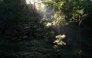
Areas of forest which grow in KwaZulu-Natal, South Africa mostly on south facing slopes in higher rainfall areas, and along the humid coastal areas. Different types of forest can be identified by their species composition which depends mostly on the altitude, latitude and substrate in which they grow. South facing slopes are favourable for the development of forest as they are more shaded, and therefore cooler and retain more moisture than the northern slopes. The extra moisture on the south slopes is not only favoured by forest trees, but also helps to prevent or subdue wildfires. Fires can also be blocked by cliff faces and rocks or boulders on these slopes, and by streams or rivers at the base of the slopes. The coastal regions are conducive to forest formation, because of high rainfall and humidity which are favoured by forest trees and also help to prevent or subdue fires. The rivers of the coastal areas are also broader than further inland, which may often prevent fires from spreading long distances, and fires generally burn uphill and therefore more often away from areas at low altitude.
A Centre of Endemism is an area in which the ranges of restricted-range species overlap, or a localised area which has a high occurrence of endemics. Centres of endemism may overlap with biodiversity hotspots which are biogeographic regions characterized both by high levels of plant endemism and by serious levels of habitat loss. The exact delineation of centres of endemism is difficult and some overlap with one another. Centres of endemism are high conservation priority areas.
The Pondoland Centre of Plant Endemism is situated in the coastal region overlapping the provinces of KwaZulu-Natal and the Eastern Cape in South Africa. It is named after Pondoland and falls within the Maputaland-Pondoland-Albany Hotspot. The region consists of grassy plateaus incised by forested ravines and gorges. The main substrate in the area is Natal Group Sandstone, which was formed by sediments laid down about 500 million years ago in a rift underlying the eastern Agulhas Sea in the ancient continent of Gondwana. The region is about 18,800 hectares in extent, and lies along the coastline stretching about 15 kilometres inland with a maximum altitude of about 400 to 500 metres above sea level. The region is essentially a transition zone between sub-tropical and temperate climates.
Isoglossa woodii, commonly known as buckweed, is a monocarpic shrub of the family Acanthaceae, growing up to 4 m tall. It grows in colonies in coastal forest areas of KwaZulu-Natal and marginally into Eastern Cape, South Africa.
Millettia grandis is a species of plant in the family Fabaceae from South Africa. It is commonly called umzimbeet which is a name derived from the isiZulu name umSimbithwa.
Deinbollia oblongifolia is a shrub or small tree in the family Sapindaceae. It is commonly known as the dune soap-berry and is found in coastal vegetation from the Eastern Cape of South Africa, through KwaZulu-Natal to southern Mozambique and Eswatini. It is named after Peter Vogelius Deinboll (1783–1876), a Danish botanist and plant collector.
Maputaland is a natural region of Southern Africa. It is located in the northern part of the province of KwaZulu-Natal, South Africa between Eswatini and the coast. In a wider sense it may also include the southernmost region of Mozambique. The bird routes and coral reefs off the coast are major tourist attractions.
Southern African Sand Forest is a sand forest, or a subtropical forest plant community of the tropical and subtropical dry broadleaf forests biome. It grows on ancient sand dunes in northern KwaZulu-Natal and southern Mozambique. In South Africa these forests are known simply as Sand Forest, while in Mozambique they are known as Licuati Forest. The Southern African sand forest is part of the Maputaland coastal forest mosaic ecoregion.
The Albany Centre of Plant Endemism is situated in the coastal region of South Africa at the eastern end of the Eastern Cape Province. It is named after the district of Albany and falls within the Maputaland-Pondoland-Albany Hotspot. It is notable for its biodiversity and unique, endemic flora and fauna.
The Maputaland Centre of Plant Endemism is situated in the coastal region of South Africa in the northern part of the province of KwaZulu-Natal, and also includes the southernmost part of Mozambique. It forms part of the Maputaland-Pondoland-Albany Hotspot. It is notable for its biodiversity and unique, endemic flora and fauna.
The Indian Ocean coastal belt is one of the nine recognised biomes of South Africa. They are described in terms of their vegetation and climatic variations.
The Biodiversity of South Africa is the variety of living organisms within the boundaries of South Africa and its exclusive economic zone. South Africa is a region of high biodiversity in the terrestrial and marine realms. The country is ranked sixth out of the world's seventeen megadiverse countries, and is rated among the top 10 for plant species diversity and third for marine endemism.
↑ Stuart, Chris; Stuart, Tilde (2007). Field guide to mammals of southern Africa (4ed.). Cape Town: Struik. ISBN978-1-77007-404-0.
↑ Sinclair, Ian; Arlott, Norman; Hayman, Peter; Sasol Industries, eds. (2011). Sasol birds of southern Africa: the region's most comprehensively illustrated guide (4th ed., fully rev. and updateded.). Cape Town: Struik Nature. ISBN978-1-77007-925-0.
↑ Gouyou Beauchamps, Pierre (January–February 2012). "Wild Coast - Les bijoux de la Côte Sauvage". Terre sauvage (in French). No.1201. pp.70–79. Caution: Dung beetles have right of way
This page is based on this Wikipedia article Text is available under the CC BY-SA 4.0 license; additional terms may apply. Images, videos and audio are available under their respective licenses.