The Neches River begins in Van Zandt County west of Rhine Lake and flows for 416 miles (669 km) through the piney woods of east Texas, defining the boundaries of 14 counties on its way to its mouth on Sabine Lake near the Rainbow Bridge. Two major reservoirs, Lake Palestine and B. A. Steinhagen Reservoir are located on the Neches. The Angelina River is a major tributary with its confluence at the north of Lake B. A. Steinhagen. Tributaries to the south include Village Creek and Pine Island Bayou, draining much of the Big Thicket region, both joining the Neches a few miles north of Beaumont. Towns and cities located along the river including Tyler, Lufkin, and Silsbee, although significant portions of the Neches River are undeveloped and flow through protected natural lands. In contrast, the lower 40 miles of the river are a major shipping channel, highly industrialized, with a number of cities and towns concentrated in the area including Beaumont, Vidor, Port Neches, Nederland, Groves, and Port Arthur.

Knysna is a town with 76,150 inhabitants in the Western Cape province of South Africa. It is one of the destinations on the loosely defined Garden Route tourist route. It is situated 60 kilometres east of the city of George on the N2 highway, and 33 kilometres west of the Plettenberg Bay on the same road.

Ezemvelo KZN Wildlife is a governmental organisation responsible for maintaining wildlife conservation areas and biodiversity in KwaZulu-Natal Province, South Africa. Their headquarters is in Queen Elizabeth Park situated on the northern slopes of Pietermaritzburg, the KwaZulu-Natal provincial capital. Prior to 1994, it was known as the Natal Parks Board.
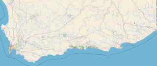
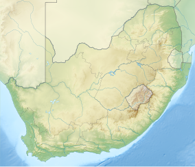
The Garden Route is a 300-kilometre (190 mi) stretch of the south-eastern coast of South Africa which extends from Witsand in the Western Cape to the border of Tsitsikamma Storms River in the Eastern Cape. The name comes from the verdant and ecologically diverse vegetation encountered here and the numerous estuaries and lakes dotted along the coast. It includes towns such as Witsand, Heidelberg, Riversdale, Stilbaai, Albertinia, Gouritsmond, Knysna, Plettenberg Bay, Mossel Bay, Oudtshoorn, Great Brak River, Little Brak River, Wilderness, Sedgefield and Nature's Valley; with George, the Garden Route's largest city and main administrative centre.

The Tsitsikamma National Park is a protected area on the Garden Route, Western Cape and Eastern Cape, South Africa. It is a coastal reserve well known for its indigenous forests, dramatic coastline, and the Otter Trail. On 6 March 2009 it was amalgamated with the Wilderness National Park and various other areas of land to form the Garden Route National Park.
The Obabika River Provincial Park is a provincial park in Ontario, Canada, straddling across the boundaries of the Sudbury, Nipissing, and Timiskaming Districts. While it is named after and includes the Obabika River, the bulk of the park extends north of Obabika Lake to the eastern boundary of Lady Evelyn-Smoothwater Provincial Park.

According to the California Protected Areas Database (CPAD), in the state of California, United States, there are over 14,000 inventoried protected areas administered by public agencies and non-profits. In addition, there are private conservation areas and other easements. They include almost one-third of California's scenic coastline, including coastal wetlands, estuaries, beaches, and dune systems. The California State Parks system alone has 270 units and covers 1.3 million acres (5,300 km2), with over 280 miles (450 km) of coastline, 625 miles (1,006 km) of lake and river frontage, nearly 18,000 campsites, and 3,000 miles (5,000 km) of hiking, biking, and equestrian trails.
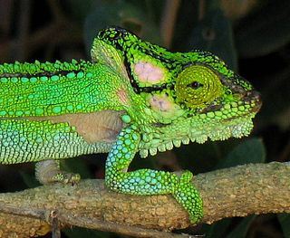
The Knysna dwarf chameleon is a species of dwarf chameleon in the Bradypodion genus that is endemic to South Africa. It is a forest dweller, found only in a limited range in the afromontane forests near Knysna, South Africa, and in certain surrounding areas.
Eastern Cape Parks are the national parks, marine protected areas, nature reserves and other nature conservation areas in the Eastern Cape province of South Africa. Eastern Cape Parks and Tourism Agency (ECPTA) is the governmental organisation responsible for maintaining wilderness areas and public nature reserves in the Eastern Cape, based in East London.
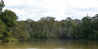
The Garden Route National Park is a national park in the Garden Route region of the Western Cape and Eastern Cape provinces in South Africa. It is a coastal reserve well known for its indigenous forests, dramatic coastline, and the Otter Trail. It was established on 6 March 2009 by amalgamating the existing Tsitsikamma and Wilderness National Parks, the Knysna National Lake Area, and various other areas of state-owned land.

Malolotja National Park covers 18,000 hectares of mountain wilderness on Eswatini's northwestern border with South Africa. The park includes Ngwenya Mountain, Eswatini's second highest mountain, and Malolotja Falls which drop 89 metres (292 ft), the highest in Eswatini. Habitats include short grassland to thick riverine scrub, bushveld and Afromontane forest.

Douala-Edéa National Park, formerly known as Douala-Edéa Wildlife Reserve, is a national park in the Littoral Region of Cameroon.

White Lake Grasslands Protected Area is a conservation site located in the Regional District of Okanagan-Similkameen of British Columbia, Canada. It was established on April 18, 2001 by an order-in-council under the Environment and Land Use Act to protect the semi-arid grassland and pine forest ecosystem west of Vaseux Lake.

The protected areas of North Carolina cover roughly 3.8 million acres, making up 11% of the total land in the state. 86.5% of this protected land is publicly owned and is managed by different federal and state level authorities and receive varying levels of protection. Some areas are managed as wilderness while others are operated with acceptable commercial exploitation. The remainder of the land is privately owned, but willingly entered into conservation easement management agreements, or are owned by various nonprofit conservation groups such as the National Audubon Society and The Nature Conservancy. North Carolina contains 1 National Park, and various other federally owned protected land including 2 National Seashores, 5 National Forests, 12 Wildlife Refuges, and the southern half of the Blue Ridge Parkway. North Carolina has an extensive state park system of 42 open units, 35 of which are state parks, 4 that are recreation areas, and 3 staffed state natural areas, along with other designated units managed by the North Carolina Department of Natural and Cultural Resources.
The Kwelera Nature Reserve is a coastal dune forest reserve in the Wild Coast region of the Eastern Cape, South Africa. Access to the reserve is through the adjacent Kwelera National Botanical Garden, where the reserve now serves as the natural portion of the garden. The reserve stretches from the Kwelera River on the eastern side, to the Gqunube River (Gonubie) at the western end of the reserve. It is a park in the greater East London Coast Nature Reserve.

The Kopka River is a river in northwestern Ontario, Canada. It forms at the height-of-land west of Lake Nipigon, flowing through rugged wilderness of Ontario's northern boreal forest, and drains into Wabinosh Lake.