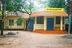
Muhamma

Last updated

Muhamma
Town
Muhamma grama panchayath.jpg
Muhamma Panchayaath Office
India Kerala location map.svg
Red pog.svg
Muhamma
Location in Kerala, India
Coordinates: 9°35′0″N76°21′0″E / 9.58333°N 76.35000°E / 9.58333; 76.35000 Coordinates: 9°35′0″N76°21′0″E / 9.58333°N 76.35000°E / 9.58333; 76.35000
CountryFlag of India.svg  India
State Kerala
District Alappuzha
Government
  Type Panchayath
  BodyMuhamma grama panchayath
Population
 (2001)
  Total24,513
Languages
  Official Malayalam, English
Time zone UTC+5:30 (IST)
PIN
688525 [1]
Vehicle registration KL-04, KL-32 [2]
Lok Sabha constituency Alappuzha
Vidhan Sabha constituency [3] Cherthala

Muhamma is a census town in Cherthala Taluk in Alappuzha district in the Indian state of Kerala. [4] It is home to Cheerappanchira kalari, where Lord Ayyappa of Sabarimala had his training in the martial arts. Cheerappanchira is an Ezhava ancestral home in Muhamma. Muhamma was the village where the Communist Party of India (Marxist) leader P. Krishna Pillai died after sustaining a snake-bite. Pathiramanal island, one of the scenic spots in vembanad lake is a part of Muhamma Panchyath.Muhamma boat jetty offers ferry services to Kumarakom and Alappuzha. Pathiramnal island can be accessed by private owned boats and also by government operated water transport.

Contents

Demographics

As of 2001 India census, [5] Muhamma had a population of 24,518. Males constitute 48% of the population and females 52%. Muhamma has an average literacy rate of 85%, higher than the national average of 59.5%: male literacy is 88%, and female literacy is 83%. In Muhamma, 10% of the population is under 6 years of age.

YearMaleFemaleTotal PopulationChangeReligion (%)
HinduMuslimChristianSikhsBuddhistJainOther religions and persuasionsReligion not stated
2001 [6] 118301268824518-89.114.066.820.000.000.000.000.00
2011 [7] 1255313308258615.48%89.033.876.730.000.000.000.010.36

Geography

Muhamma is a small village in Alappuzha. Pathiramanal is a small island and tourist attraction in Muhamma. Kanjikkuzhi, Mannanchery and Thanneermukkom are neighbouring villages of Muhamma.

Transport

Government ferry is available to Kumarakom, Cheepunkal and Maniaparampu

Ferry Services from Muhamma
DestinationDepartureRouteComments
Kumarakom5:45, 6:30, 7:15, 8:15, 9:00, 10:00,
11:00, 11:45, 13:00, 13:45, 14:45,
15:30, 16:30, 17:15, 18:15, 19:00
Across Vempanad Lake2 wheelers can be carried

Disclaimer: Depend on operating conditions

Maniaparambu11:00Cheepunkal[11:30]
Pathiramanal IslandSpecial(on-Demand)Tourists can book special boat
Contact Muhamma Station:9400050331

Related Research Articles

Alappuzha district District in Kerala, India

Alappuzha district, is one of the 14 districts in the Indian state of Kerala. It was formed as Alleppey district on 17 August 1957, the name of the district being changed to Alappuzha in 1990, and is the smallest district of Kerala. Alleppey town, the district headquarters, was renamed Alappuzha in 2012, even though the anglicised name is still commonly used to describe the town as well as the district.

Pala, Kerala Town in Kerala, India

Pala is a town and a municipality in Kottayam district of Kerala, India. It is the headquarters of the Meenachil taluk and the Pala Revenue Division.

Kokkamangalam Village in Kerala, India

Kokkamangalam also known as Gokkamangalam is a village in Alappuzha district of Kerala state, south India. It is situated in between Cochin and Kumarakom and on the western shore of Vembanad Lake, 5 km east of the town of Cherthala, which has the nearest railway station.

Kumarakom Tourist village in Kerala, India

Kumarakom is a popular tourism destination located near the city of Kottayam, in Kerala, India, famous for its backwater tourism. It is set in the backdrop of the Vembanad Lake, the largest lake in the state of Kerala.

Vaikom Municipality in Kerala, India

Vaikom, IPA: [ʋɐjkːɐm], is a municipal town and a capital town of Vaikom Taluk, situated in the northwest of Kottayam district in the state of Kerala, India. The town is also noted for its role in the Indian independence movement for being the venue of Vaikom Satyagraham, a civil rights movement aimed at securing freedom of movement for all sections of society through the public roads leading to the Vaikom Shiva Temple.

Vembanad Lake in Kerala, India

Vembanad is the longest lake in India, as well as the largest lake in the state of Kerala. With an area of 2033 square kilometers and a maximum length of 96.5 km, it is the second largest Ramsar site in India only after the Sunderbans in West Bengal. Spanning several districts in the state of Kerala, it is known as Vembanadu Lake in Kottayam, Vaikom, Changanassery, Punnamada Lake in Alappuzha, Punnappra, Kuttanadu and Kochi Lake in Kochi. Several groups of small islands including Vypin, Mulavukad, Maradu, Udayamperoor, Vallarpadam, Willingdon Island are located in the Kochi Lake portion. Kochi Port is built around the Willingdon Island and the Vallarpadam island.

Ambalappuzha Town in Kerala, India

Ambalappuzha is a small town in the Alappuzha district of Kerala state, India. It is located 14 km (8.7 mi) south of Alappuzha which is the district headquarters.

Pathiramanal Island in Kerala, India

Pathiramanal is a small island inMuhamma panchayat of Alappuzha district. The name Pathiramanal means 'midnight sand'. The scenic beauty of both sides of the lake as well as that of the island is mind blowing. It is home to many rare varieties of migratory birds from different parts of the world.

Tirur Municipality in Kerala, India

Tirur is a Municipality in Malappuram district in the Indian state of Kerala spread over an area of 16.55 square kilometres (6.39 sq mi). It is one of the business centers of Malappuram district and is situated 26 kilometres (16 mi) west of Malappuram and 52.5 kilometres (32.6 mi) south of Kozhikode, on the Shoranur–Mangalore section under Southern Railway. Tirur is also a major regional trading centre for fish and betel leaf and has an average elevation of 2 metres.

Kayamkulam Town in Kerala, India

Kayamkulam is a town and municipality in the Onattukara region of Alappuzha district in Kerala. It is the second biggest town in Alappuzha district. It is located on the western coast of India, and was an ancient maritime trading center. One of the largest thermal power plants in Kerala, the Rajiv Gandhi Combined Cycle Power Plant run by the NTPC, is situated at Haripad. Kayamkulam is part of the Karthikappally tehsil. Krishnapuram Palace is located nearby.

Alappuzha City in Kerala, India

Alappuzha or Alleppey is the administrative headquarters of Alappuzha district in state of Kerala, India. The Backwaters of Alappuzha are one of the most popular tourist attractions in India which attracts millions of domestic and international tourists.

Kottayam City in Kerala, India

Kottayam, IPA: [koːʈːɐjɐm] is a city in the Indian state of Kerala. Flanked by the Western Ghats on the east and the Vembanad Lake and paddy fields of Kuttanad on the west, Kottayam is a place that is known for extraordinary qualities. It is the district headquarters of Kottayam district, located in south-west Kerala. Kottayam is located in the basin of the Meenachil River at an average elevation of 3 metres (9.8 ft) above sea level, and has a moderate climate. It is located approximately 155 kilometres (96 mi) north of the state capital Thiruvananthapuram.

Arookutty is a census town in Alappuzha district in the state of Kerala, India.

Chittur-Thathamangalam Municipality in Kerala, India

Chittur-Tattamangalam is a green town in Palakkad district of Kerala State, India. It is the headquarters of Chittur taluk, 13 km (8.1 mi) away from Palakkad towards the south-east, on the banks of Kannadipuzha, a major headstream of Bharathapuzha, the second longest river in Kerala. It was once part of the erstwhile Kingdom of Cochin.

Kokkothamangalam is a census town in Alappuzha district in the Indian state of Kerala.

Ramankary is a village in the Kuttanad region of India. It is 9 km away from Changanacherry town and 17 km from Alappuzha city. It is one of the villages in Alapuzha on the bank of the Manimala River with picturesque vast paddy fields.

Pandanad Village in Kerala, India

Pandanadu is a village in Chengannur taluk in Alappuzha district, in Kerala, India. According to the 2001 Indian census, Pandanad has a population of 12,466 people.

Kodamthuruth is a village in Alappuzha district in the Indian state of Kerala. It is a panchayat, which comes under the Aroor Assembly constituency.

Vechoor Village in Kerala, India

Vechoor is a village in Vaikom taluk, Kottayam district in the state of Kerala, India. Vechoor is a short drive away from one of Kerala's tourist destinations, Kumarakom. The Vechur Cow breed of cattle is named after this village.

Kanjikuzhi is a census town and Panchayat in Alappuzha district of Kerala State, India. Kanjikuzhi is located 16 km (9.9 mi) north of District headquarters Alappuzha and 7 km (4.3 mi) south of Cherthala.

References

  1. "Welcome to the Indiapost Website". Archived from the original on 20 May 2012. Retrieved 16 December 2008.
  2. http://www.keralamvd.gov.in/index.php?option=com_content&task=view&id=121&Itemid=5
  3. "CEO Kerala :: Alappuzha".
  4. "മുഹമ്മ ഗ്രാമപഞ്ചായത്ത് (Muhamma Grama Panchayat) » മുഹമ്മ". Archived from the original on 9 October 2011. Retrieved 11 July 2011.
  5. "Census of India 2001: Data from the 2001 Census, including cities, villages and towns (Provisional)". Census Commission of India. Archived from the original on 16 June 2004. Retrieved 1 November 2008.
  6. Census India 2001.
  7. Census India 2011.